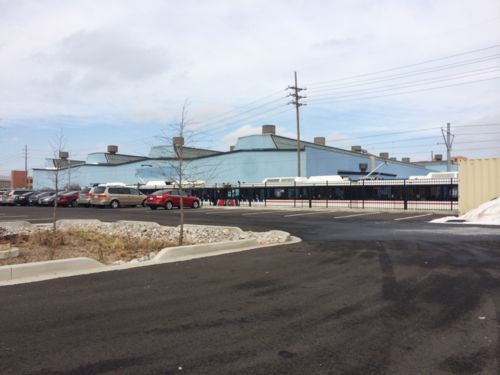
Yesterday I decided to use a gift card I had for Crate & Barrel. We’d had warmer weather and rain to help clear away the snow. Unfortunately I encountered a problem as I approached The Boulevard.
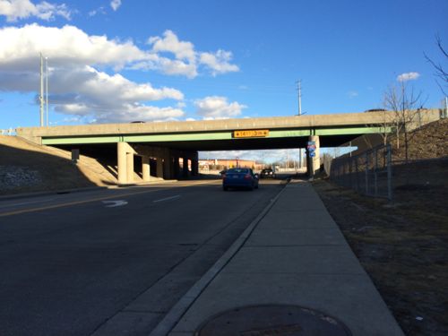
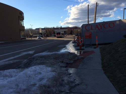
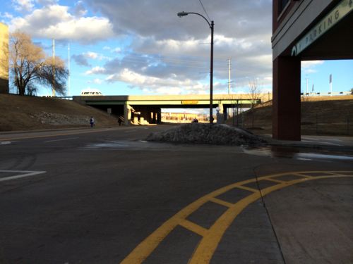
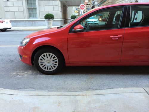
As I got to The Boulevard I found a massive pile of snow blocking the wheelchair ramp. 3:42pm on Monday January 13, 2014. High temp yesterday was 55 degrees.I had to turn around and go back to the MetroLink station to cross to the other side.I briefly thought I wouldn’t be ab;e to get through, I crossed mid-block. Crate & Barrel is on the left.After I made my purchase I got a pc of the other side of the snow pile blocking the most direct route.
The Boulevard is owned by developer Pace Properties. Here’s how they market the development:
In the heart of St. Louis is a lifestyle destination unlike any other. The Boulevard – Saint Louis is a vibrant village with a unique blend of upscale retail, fine dining, and luxury residences. Home to retailers and restaurants such as Soft Surroundings, Loft, Crate & Barrel, P.F. Chang’s China Bistro and Maggiano’s Little Italy, The Boulevard is the premier lifestyle development in the St. Louis metropolitan area. Take a stroll down the shops of Main Street and sit back and relax on the patio of our restaurants. (The Boulevard)
“Vibrant village” huh? Right…. I shouldn’t be surprised since their “visit us” page gives driving directions, no mention of public transit.
As I was checking out at Crate & Barrel the clerk asked me how may day was going, I said “Great, but I had a hard time getting here.” I showed her the first picture above. She was shocked so she called the store manager over. I showed the manager the same picture and she said she’d talk to Pace Properties.
UPDATE: Response from Pace Properties received 1/14/14 @ 2:45pm:
Steve:
As property manager of The Boulevard Saint Louis, I am sorry to hear about your recent experience. Pace Properties takes accessibility issues very seriously. For example, at the Brentwood Square Shopping Center we recently did a large, and costly, project overlaying the parking lot and replacing the handicap ramps in front of each store to ensure that we had ADA compliant paths. Unfortunately, the mound of snow that restricted your path adjacent to The Boulevard was pushed there by the county when they were clearing Galleria Parkway. We do not have any surfaces in that vicinity that would necessitate snow clearing due to the covered garage – with the exception of the small entrance/exit to the garage and the sidewalk. I have spoken with our snow removal vendor and they have been instructed to clear future obstructions from the ADA accessible ramp.
Thanks for contacting us regarding this issue. We appreciate visitor feedback and hope that we can make your next visit a more enjoyable experience.
For 9+ years now I’ve written thousands of posts advocating for a better St. Louis. I know that getting developers to just meet the minimum requirements of our local building & zoning codes, the minimum guidelines of the American’s with Disabilities Act of 1990, etc. will not create great public & private spaces. That will, at best, make sure development won’t harm the public by collapse and not infringe the civil rights of the disabled.
To create great spaces it takes everyone (citizens, developers, business owners, architects, civil engineers, etc) looking at a site and thinking “what would make this great?” not, “what’s the least we can get away with?” We need a process in St. Louis to examine developments with respect to pedestrian access. If we did we’d see better connected projects — and more pedestrians. Let’s take Gravois Plaza as an example.
The old Gravois Plaza was razed and a new development built on the site, in December 2004 I wrote:
I’m in this area 2-3 times per week and I have always seen pedestrians taking this unfriendly route. I guess one could take the attitude that people are walking anyway so what is the big deal. However, the message to people is clear – if you don’t have a car we really don’t give a shit about you. Sure, we don’t mind if you walk here to spend your money but don’t expect us to go out of our way to do anything for you.
In the meantime the parking lot is way too big and has so few trees it is almost comical. How is it TIF financing can be used to finance a project that is closed to the neighborhood to the West & North, is anti-pedestrian and is mostly paving? Our city must not have any codes requiring a connection to the neighborhood, pedestrian access and even something so basic as a reasonable level of landscaping.
The old Gravois Plaza, for all its faults, was more accessible to neighbors to the North. People could enter at Potomac & Gustine and enter the courtyard space. So while the new Gravois Plaza is cleaner and features a nice Shop-N-Save store it is less pedestrian-friendly than the old Gravois Plaza.
So what would I have done you ask? Well, I would have destroyed the wall along Gustine and connected the development to the neighborhood by regrading the site. To achieve a true connection to the surrounding neighborhoods I would have divided the site back into separate blocks divided by public streets. Hydraulic Street, the South entrance along Gravois, would be cut through all the way North to Potomac Street. Oleatha & Miami streets would be cut though between Gustine on the West to Bamberger on the East. This, of course, is completely counter to conventional thinking about shopping areas.
With all these new streets plenty of on-street parking could have been provided. Several small parking lots could be provided as necessary. Arguably, less total parking could have been provided as you’d have more people willing to walk from the adjacent neighborhoods. Ideally, some new housing would have been provided above some of the retail stores. Big Box stores like the Shop-N-Save have been integrated into more urban shopping areas in other cities – it takes a willingness on the part of the city to show developers & retailers the way. The smaller stores would easily fit within a new street-grid development.
A substantial amount of money was spend rebuilding Gravois Plaza but the area is not really a part of the city. It is a suburban shopping center imposed upon the city. This could have been so much more.
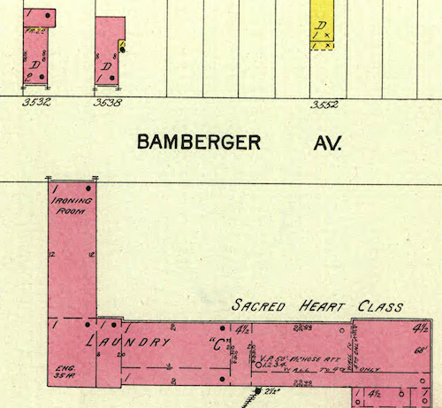
I now know the site never had cross streets, the Sisters of the Good Shepherd convent was built on 11 acres in 1895.
A 1903 Sanborn map shows the convent pre-dated much of the housing. Click image to view on the UM Digital LibraryWe can see the east wing extended all the way to the property line at Bamberger Ave., more connection than the two iterations of Gravois Plaza since
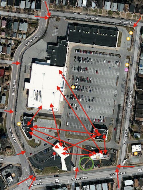
The original Gravois Plaza, built in 1971, didn’t consider pedestrians from the surrounding neighbors or via bus on Gravois. Thirty years later the same mistake was repeated when the site was cleared and rebuilt. In 2001/2002 we knew better but with no formal policy on pedestrian access the new project got financial help to take place.
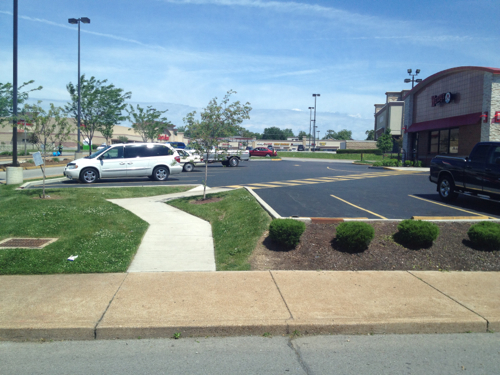
A pedestrian policy would require an analysis of pedestrian access points and a pedestrian circulation plan. Of the five buildings on the site of the convent only one, the Wendy’s built in 2010, connects to the sidewalk. None connect to each other.
The ADA route from the public sidewalk to the suburban-style Wendy’s
Some people, those who champion the lowest common denominator, seem to think everyone drives everywhere. They’ll point to awful anti-pedestrian areas and say “See, I told you nobody walks here.” They ignore the path worn in the grass of pedestrians finding their way to their destinations. People walk, especially to buy groceries, even if the environment isn’t designed for walking.
We live in a city where many use public transit and walk daily, why not design new development to accommodate them as well as the motorist?
The red arrows are how pedestrians access the site and needed internal connections. The green circle is the walkway to Wendy’s. Original image: Apple Maps, click to view in Google Maps.
It starts when a site is targeted for development. It might be an old industrial site or a place that’s been vacant for decades, so no pedestrian traffic exists. But the point of new development is to attract people — to jobs and retail services. Some will walk.
Questions to ask at the start:
What direction(s) will pedestrians come from to reach the site? Can we anticipate more pedestrisns at some arrival points versus others?
Will the site have more than one building when fully built out? How will each be reached from outside the site and from each other?
Can we make the design pleasant enough that people walk to the site rather than drive, allowing for a reduction in the amount of surface parking needed?
Can we arrange the building(s) so those who arrive via car to park and walk from store to store?
Can planter areas next to the pedestrian route(s) be used to catch & retain storm runoff?
It costs little, does no harm, to ask these questions at the earliest stages of a project. Asked later and the answer is likely to costly to make changes. Never asking them risks a ADA discrimination complaint.
We can build better developments that are welcoming to everyone, and don’t need a new government incentives to be razed and replaced 10-30 years later!
Cortex is a district created by a collaboration of numerous research institutions, self-described as:
Founded in 2002, Cortex is mid-America’s premiere hub for bioscience and technology research, development and commercialization, anchoring St. Louis’ growing ecosystem of innovative startups and established companies. Providing state-of-the-art facilities to support the nation’s most promising technological advances, Cortex offers custom lab and office space, proximity to world-class research institutions, a highly-trained tech workforce, access to venture capital…all surrounded by amenity-rich urban neighborhoods.
Cortex is conveniently located next to I-64 and easily accessible via private or public transportation. The area is home to some of St. Louis’ most exciting attractions and neighborhoods. In addition to being neighbors with other leading science and technology companies, you are within easy reach of Forest Park, which is larger than New York’s Central Park, the St. Louis Science Center, the St. Louis Zoo, The Muny and many other cultural and entertainment centers. Midtown is also home to charming sidewalk cafes, galleries, antique shops, boutiques and pubs. The area has been described as a little European, a little New York, and totally St. Louis.
For a while now Cortex has been working to add a new transit station along the existing MetroLink light rail line. I don’t know if it has been given the green light, but it has been studied at great length. Here are some quotes from a June 2013 ULI Technical Assistance Panel Report:
By placing the station as close to Boyle as possible, riders would be welcomed to the District by the Commons, thereby creating an impressive and distinctive park-like ‘front door’ to the District. The station would be also easily visible from Boyle, making way-finding easier and promoting future ridership by virtue of its visibility to auto traffic.
While the station should be placed close to Boyle, the Panel still felt strongly that the station should be accessible to pedestrians and bicyclists via entrances at Boyle and Sarah, providing riders with two options for ingress/egress. Directional signage should also be placed on and highly visible from both streets to assist passengers with finding the station entrance. (p5)
Of immediate note was the current state of the streets and pedestrian experience in the District. There is a significant amount of overgrowth in the area, particularly along sidewalks, which leaves visitors with a sense that the area is largely ignored or abandoned. To truly operate as a District, care should be taken to maintain the sidewalks and streetscapes throughout the area, not just those in the immediate vicinity of current or complete development. (p10)
With the station nearing reality and additional businesses planning to bring innovation and employees to the District, the members of Cortex are faced with another opportunity to come together once again to solve a need. In this instance, the challenge is parking in the District. By creating a parking district or ownership/management entity consisting of the five Cortex members, a more thoughtful and comprehensive strategy can be put in place which will address future parking needs, create a unified parking solution that is in keeping with the design and operational principles of the District, and help determine the most advantageous pricing strategy that will meet the needs of the consumer, fund the parking entity, and ultimately provide for a system of parking that is successful and sustainable. (p12)
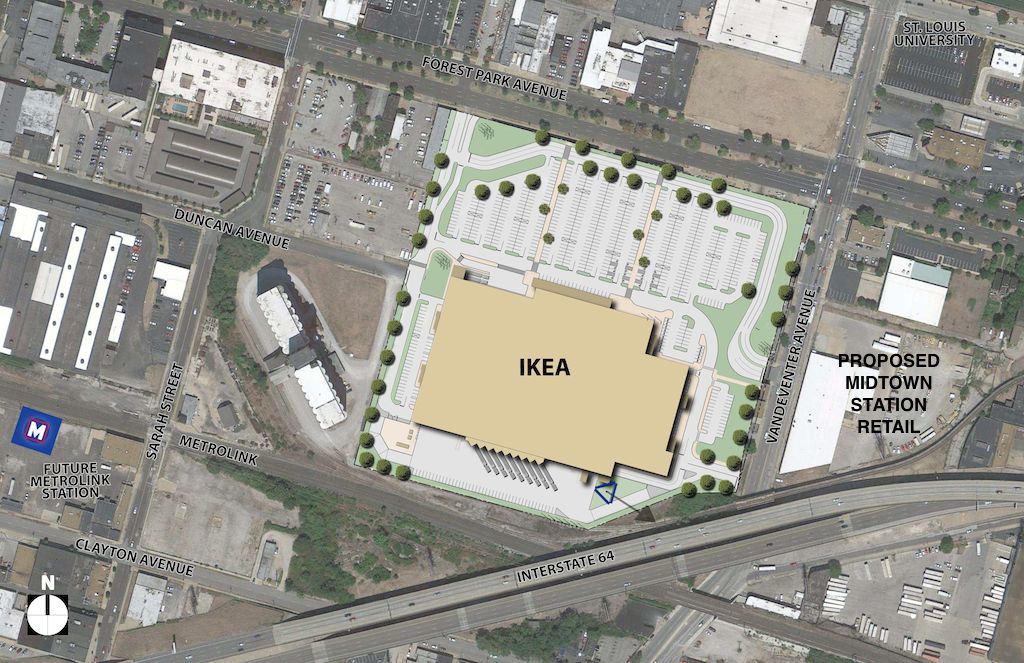
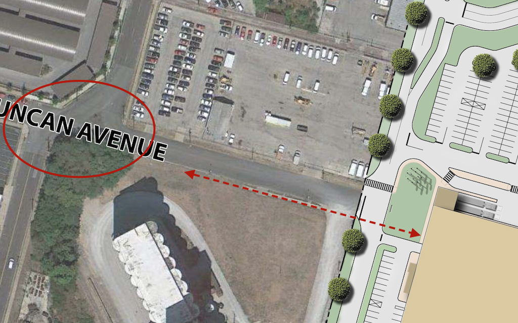
The report also talks about Cortex’s plan to make Duncan Ave a pedestrian-oriented street. I know from personal experience it’ll need a lot of work to get to that point. Cutting off Duncan before it reaches Vandeventer isn’t a good idea, though IKEA could be used a nice terminus.
However, St. Louis has more than two decades of experience with light rail stations surrounded by anything but good transit-oriented development (TOD). Now’s the opportunity to change. I’ve yet to see any evidence, ULI study included, that anyone has looked at the route(s) pedestrians would take to get to/from this proposed station and all the building sites within the district.
Are there barriers to pedestrian circulation within the district? (hint, yes)
Is the pedestrian network sized and designed to handle expected foot traffic at build out? (no)
Does the existing pedestrian network have ADA-compliance issues? (Big YES)
Does the existing pedestrian network encourage transit use and/or walking? (no)
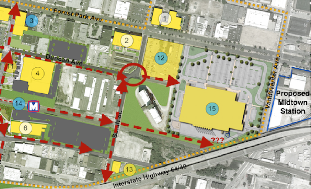
How will pedestrians get from the proposed MetroLink station to the proposed Midtown Station retail development across Vandeventer? (see below)
With these asked and identified new work can be built to reduce problems, not create new ones, and gradually improve the area. Let’s take a look at some specifics:
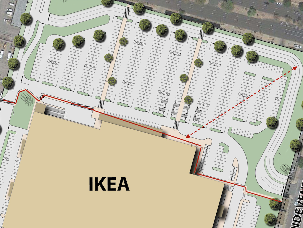
Proposed site plan for the IKEA, I marked the area to the east to indicate the proposed retail development. Click image to view larger version.Looking east from in front of the grain silo toward the future IKEA. A sidewalk exists currently.Current site plan doesn’t show pedestrian access from the south side of Duncan Ave., intersection at Sarah needs to be addressed to connect IKEA to MetroLink. Click image to view larger version.For pedestrians going from MetroLink or other locations to Midtown Station is means taking a convoluted route in front of IKEA. For SLU students arriving at the corner of Forest Park & Vandeventer they’ll likely cut through the parking lot rather than use the ADA accessible routes. Click image to view larger version.
IKEA’s Reed Lyons told me they tried different configurations, including pushing the building out to the corner so it would be more urban. I believe him, but this is the “show-me” state so I’d like to see these rejected configurations. It’s like in school when you had complicated math problems — you had to show your work.
I also want to explore the width of Forest Park and Vandeventer. Both have a parking lane, roughly 10ft wide, that will become useless since there isn’t a reason to park on the street. Will this lane but used to direct traffic into the IKEA or can we do curb bulbs or other treatments to reduce the width of the roadway? There’s no reason to leave unused paving.
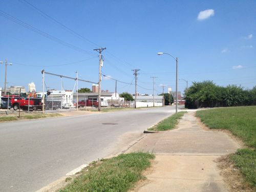
I do have one idea on how to get pedestrians from the proposed MetroLink to Vandeventer and the proposed Midtown Station retail project — a pedestrian route next to the tracks.
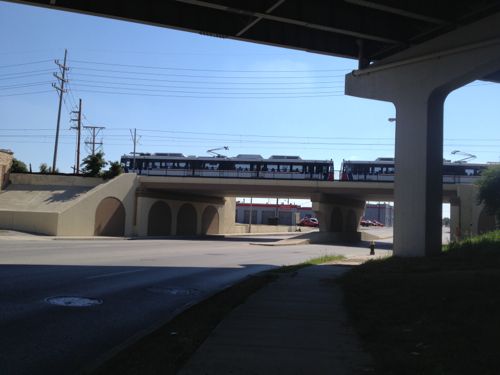
Overview of pedestrian routes that need examination. A direct path next to the track down to Vandeventer could help increase the walkability of the area, serving as another way for SLU students to reach a light rail station. Click image to view a larger version.MetroLink train crossing over Vandeventer. A pedestrian path next to the tracks is not unlike the bike/ped peth in St. Clair County, click for information.
I’m excited about IKEA and realize it and Cortex have a lot of potential for St. Louis and the region. I also know just plopping in a light rail station doesn’t automatically create a vibrant & walkable neighborhood/district. Planning today will pay off in the long run.
Not every crosswalk point in the city is marked with paint. Ninth Street at St. Charles St was such an example, a well-used point that was unmarked. Hotel guests cross here to reach the parking garage. But unmarked crossing points can inadvertently get blocked by motorists.
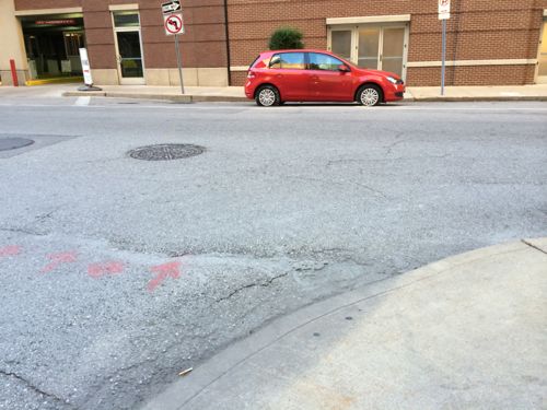
November 4th a VW Golf is parked blocking the ramp to cross 9th at St. Charles St.As seen from the opposite corner
The lane where the Golf is parked is has been marked as no parking for a long time, not sure why. On the morning of December 4th I met with traffic commissioner Steve Runde to discuss allowing parking on 9th, mentioning a crosswalk designation would be nice. The following morning it was already done!
By December 5th the crosswalk had been painted.
Should the crosswalk get blocked now it’ll be easier to get parking enforcement to issue a ticket. Once the parking meters get installed on 9th I’ll do another post.
Thanks to Steve Runde for listening and responding!
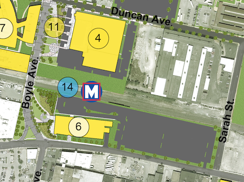
The newly completed BJC @ The Commons is an example of what not to build next to a proposed light rail station.
Looking west through new surface parking lotMetroLink train heads eastBJS @ The Commons (6) is adjacent to the proposed transit station (14)The industrial building that was razed filled the site, including being built up to the Clayton Ave sidewalkBJC @ The Commons is set back in office park fashion, even though the grass is green this isn’t an environment designed to attract pedestrians.
All brand new, from scratch. Totally wrong. Transit passengers see little but parking, why exit and walk? On Clayton Ave pedestrians don’t have a sense of enclosure — the building it too far back from the narrow sidewalk.
Unfortunately the people planning the CORTEX area don’t understand pedestrian behavior and how to create a vibrant transit-oriented environment. Office park next to tracks doesn’t cut it.
AARP Livibility Index
The Livability Index scores neighborhoods and communities across the U.S. for the services and amenities that impact your life the most
Built St. Louis
historic architecture of St. Louis, Missouri – mourning the losses, celebrating the survivors.
Geo St. Louis
a guide to geospatial data about the City of St. Louis