Home » Walkability » Recent Articles:

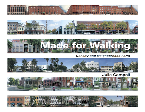
Reading: Made for Walking by Julie Campoli

Every so often I get a book to review that I keep repeating “Yes!” as I go through it, Made for Walking is that sort of book:

Landscape architect and urban designer Julie Campoli challenges our current notions of space and distance and helps us learn to appreciate and cultivate proximity. In this book, developed as a follow-up to Visualizing Density (2007, co-authored with aerial photographer Alex S. MacLean), she illustrates urban neighborhoods throughout North America with hundreds of street-level photographs.

Researchers delving into the question of how urban form affects travel behavior identify specific characteristics of place that boost walking and transit use while reducing VMT. In the 1990s some pinpointed diversity (of land uses), density, and design as the key elements of the built environment that, in specific spatial patterns, enable alternative transportation. After a decade of successive studies on the topic, these “three Ds” were joined by two others deemed equally important—distance to transit and destination accessibility—and together they are now known as the “five Ds.” Added to the list is another key player: parking.

This book should be required reading for everyone involved in neighborhoods, development, transit in the St. Louis region – especially St. Louis aldermen. Camponi articulates why it is beneficial to change land use patterns, accompanied by hundreds of images to make her points.

Cover of Made for Walking: Density and Neighborhood Form by Julie Camponi. Click image for the publisher's page
Cover of Made for Walking: Density and Neighborhood Form by Julie Camponi. Click image for the publisher’s page with free chapter download

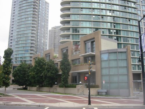
One example I recognized immediately, the Coal Harbour area of Vancouver BC. Here the sidewalks in an area of new high rise buildings are pleasant because smaller-scale buildings front onto them, defining them.

ABOVE: The Coal Harbor area of Vancouver in 2003
ABOVE: The Coal Harbour area of Vancouver in 2003. Click image to view neighborhood in Google Maps.

Here is the chapter list:

  • Everything is somewhere else
  • Five Ds and a P
  • Neighborhood Form
  • Twelve places made for walking
  • Low-carbon neighborhoods
  • The shape of things to come
  • Good bones

Highly recommended!

— Steve Patterson


Walking From Hotel To Restaurant

In September 2010 I posted about the disconnect between a hotel and restaurant in Joplin (see Driving Next Door For Dinner) where I said the design made it difficult if someone wanted to walk next door for dinner after they checked into their room. Last week this hypothetical situation became reality in Amarillo Texas.

I was in Amarillo TX for the funeral of an 80 year old uncle, seven of us were staying in the same Holiday Inn Express. After the service some went back to the hotel to rest, my brother and I to check in. Three other relatives were going to come over to the hotel and the ten of us would walk together to the Texas Roadhouse restaurant, conveniently located right in front. This proved easier said than done.

ABOVE: Aerial view with the Holiday Inn Express on bottom facing the back of the Texas Roadhouse on top
ABOVE: Aerial view with the Holiday Inn Express on bottom facing the back of the Texas Roadhouse on top. Click image to view in Google Maps.

In my family I’m younger than all my cousins — by up to 19 years. Still, I’m the only one that walks with a cane. Our aunts and uncles are now in their 70s and 80s — one aunt will be 90 in a few months. Our group of ten was seven cousins, two aunts & an uncle. An aunt & uncle, both in their 80s,  require help to walk steady on level ground. Especially to cross an obstacle course like the one we encountered.

ABOVE: This was the barrier we had to cross twice.
ABOVE: This was the barrier we had to cross twice. The Holiday Inn is on the left, Texas Roadhouse on the right.

I suppose the three of us could’ve gotten in a car to drive from one side of the divider (above) to the other side, but that shouldn’t be necessary. The point where we crossed going to dinner the step down from the sidewalk to the grass was taller than most curbs. Returning to the hotel we found a spot that wasn’t so bad.  I suppose we could’ve walked around this barrier but that would’ve put us in a busy drive and meant walking a greater distance, a problem for all three of us.

We’ve built so much in every city like this that requires a car to get anywhere, even next door. I hope to live long enough to see the day when this is no longer the norm.

— Steve Patterson


Icy Sidewalks Hard To Navigate In Power Chair

Winter weather has arrived, my first post-stroke winter without a car. I can bundle up to deal with cold temperatures, but modest snow can leave me stranded at home or looking for alternate routes.

ABOiVE: Our recent light snow made this stretch of sidewalk along Olive nearly impassable.

I frequently take the sidewalk along Olive (above) from 16th to 14th to reach transit options. I passed over the ice you see but it was very rough, not easy on my power chair. If we’d have had more snow I couldn’t have gotten through this way.

I’ll learn which sidewalks get cleared and which do not, altering my route to avoid problem areas.

— Steve Patterson


Crossing Kingshighway

In June I did a post about being unable to active a pedestrian signal at Kingshighway & Devonshire (see Pedestrian Signal Activation Button Beyond Reach).  That button got relocated after I pointed out the absurd location. Last week I used the next crossing to the north, at  Kingshighway & Sutherland.  Yes, you guessed it, another pedestrian button not reachable from the sidewalk.

ABOVE: Why bother putting a button at all if it can't be reached?
ABOVE: Why bother putting a button at all if it can’t be reached?
ABvOVE: A woman waited on the other side of Kingshighway also waiting for the walk signal to come on.

I eventually wheeled into the grass to press the button because it didn’t seem like it would change without doing so. Even after pressing the button it took many minutes to give the  ok to cross the street.

A week earlier I spotted another problem button from the #11 (Chippewa) MetroBus.

ABOVE: The 2nd button to cross Chippewa is located in an impossible to reach location.

The Chippewa button I emailed in to the Streets Dept while I was still on the bus. I’m notifying the city of the problem at Sutherland via this post. To be fair, many intersections are great for pedestrians.But we tend not to remember that which works like it should, we remember those that give us fits.

Eventually I hope to gather volunteers and do a pedestrian audit of an area — signals, crosswalks, ramps, etc.  In the meantime I’ll catch them one at a time as I go about my daily life in various parts of St. Louis.

— Steve Patterson


Mercedes Drivers: Stop At The Stop Line, Yield To Pedestrians In Crosswalk

I often think drivers need to be retested to understand basics of the road like you stop behind the stop line or yield to pedestrians in the crosswalk. But retesting everyone would be a huge undertaking so based on two experiences at 11th & Washington Ave I say first retest drivers of silver Mercedes cars.

ABOVE: A NB motorist technically ran the light by stopping past the stop line. July 2012
ABOVE: A NB motorist technically ran the light by stopping past the stop line. July 22, 2012 @ 11:08am
ABOVE: He continued NB once he had a green light

As I crossed 11th I had to go around his car, the ADA ramps are located at the right edge of the crosswalk. I gave him a dirty look and rather than put his car in reverse and back up, he smiled, laughed and flipped me off when he got a green light.

Then last week and unbelievable situation, just as I was entering the crosswalk (with the appropriate crosswalk signal) a Mercedes stops in front of me blocking me from crossing 11th. The driver hadn’t seen me because she was looking to the west for a break in traffic so she could turn right onto Washington Ave.

ABOVE: Just as I enter the crosswalk this driver stops in front of me.
ABOVE: Just as I enter the crosswalk this driver stops in front of me. December 13th @ 7:07pm

I began speaking loudly and she looked around and noticed me. Startled she lowered her passenger window and asked if I hit her car. No, I replied but I’d like to cross the street while the walk signal is on. “Cause if you hit my car it’ll be the last time you do!” Seriously, a woman in a  Mercedes just threatened a disabled guy in a wheelchair!

ABOVE: She finally makes her right turn as she yells obscenities at me.

I was furious both times but this last time I was threatened. I was going to call the police but two blocks closer to home I saw two police officers get in their patrol car. I pull up and explain what happened. I show them the pics and one cop says she knows who the woman is, they’ll pay her a visit.

That night I emailed Director of Streets, Todd Waelterman, asking the one spot be changed to a no right turn on red. He’s concerned about traffic flow, I’m concerned about crossing the street safely. In the meantime motorists, especially those of you that drive silver Mercedes: The stop line exists for a reason — you’re supposed to stop at that line or proceed to make a right turn on red when clear. Clear means no traffic but also no pedestrians trying to cross. Got it?

— Steve Patterson


Advertisement


[custom-facebook-feed]

Archives

Categories

Advertisement


Subscribe