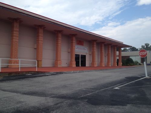
Construction workers are busy building a new child care center near the Wellston MetroLink station:
The Wellston Developmental Child Care Center is a key component of the Wellston Sustainable Neighborhood Initiative Masterplan. Located adjacent to a Metrolink Light Rail Sytstem (with which it will share parking) as well as being in close proximity to the Metropolitan Enterprise Center (a new job training center) will allow the Development Center to attain the goals of providing early childhood education in a depressed neighborhood, preparing children for the K-12 system, and providing day care assistance for parents training for new jobs.
The 14,650 SF building is oriented primarily on an E-W axis maximizing orientation for energy efficiency and daylighting. The building footprint had been placed on the site to minimize driveway length and take advantage of the adjacent public parking. Stormwater from the site will be handled by a series of micro-detention areas integrated with native landscaping. The program includes public, administrative, infant/toddler, classrooms and support spaces. (Hellmuth + Bicknese Architects)
I’ve requested the site plan & Wellston masterplan from the architects & county economic council, neither have been received.
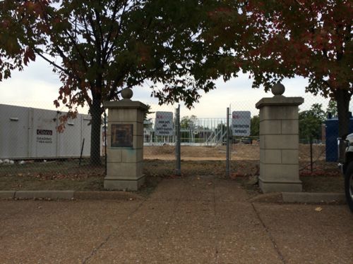
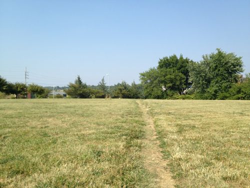
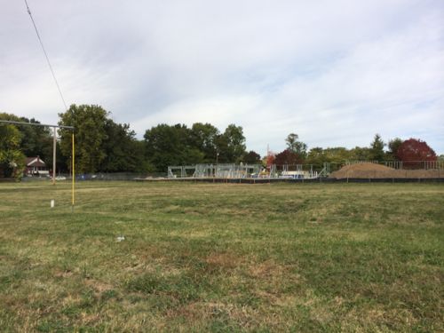
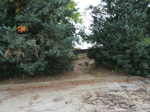
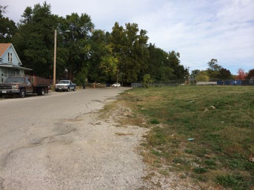
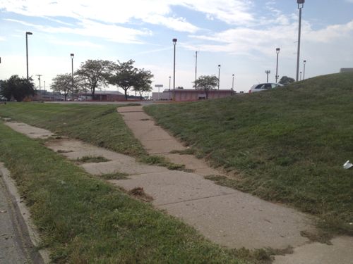
Construction of the building in Powell Park, seen from the far end of the station’s park-n-ride lotLast year Powell Park was just a field that area residents cut through to reach the bus & train. Click image for post.The long used shortcut is now blockedFrom the parking lot we see the point where the shortcut comes through the greenery
The shortcut was the most direct path for pedestrians to reach public transit. It wasn’t even paved, but since 1993 it was heavily used. However, I support building on the field — especially facilities that’ll benefit the community.
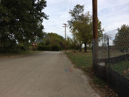
How will pedestrians now reach the station?
Rather than cut through the field to the right, pedestrians must now walk along Werley AveJust past the construction fence is the west edge of the large station parking lot.Turning east we see the parking lot, the station is at the bottom of the hill. The stop for the #94 MetroBus is on the left
The new child care center will use the existing parking, rather than have a separate parking lot. Still, the parking lot remains a divider between train, bus, residents, and new child care center. It’s possible pedestrian routes will be constructed in the parking lot to connect these elements. Without pedestrian connections the new construction is just transit-ajacent, not transit-oriented.
Once I see an actual site plan I’ll post an update.
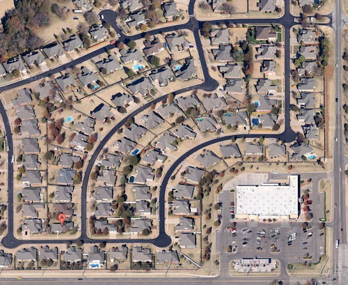
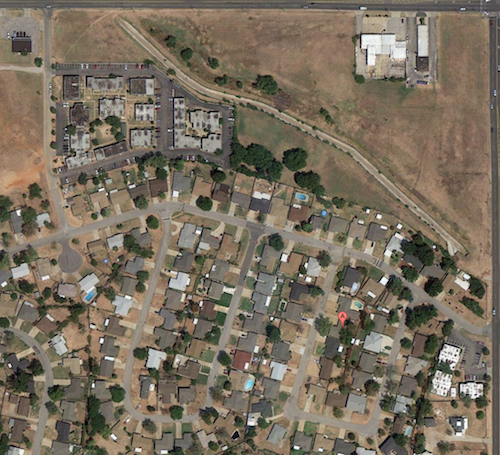
Today cul-de-sac subdivisions are designed exclusively for the automobile. For example, my brother’s gated subdivision in Oklahoma City has internal sidewalks that don’t lead you outside the gates. A major grocery store occupies one corner on the outside, but you need a car to get there.
My brother’s house “A” is so close to a large grocery store, but you can’t walk there. One of the two gates is in the upper right corner. Source: Google maps
My parents built a new custom home in 1965-66, moving in just months before I was born. I was told the streets of the new subdivision in the former farm field were still getting paved as our house was being built. Unlike where my brother lives now, we could at least reach a convenience store from a street connected to our subdivision. Had more commercial been built on land set aside by the developers we would’ve had many more options.
I grew up in a 1960s subdivision that lacked sidewalks, but there was a small store I could walk/bike to (upper left), and room for more commercial development that has never materialized.
However, many in the St. Louis region grew up in a 1950s subdivision that planned for walking, with sidewalks and a shopping center connected to the housing. I posted yesterday about the Carrollton subdivision decimated for runway expansion at Lambert International Airport, today is a look at the thought and planning that went into it.
The following is from page 547 of the 1970 book This is Our Saint Louis by Harry M. Hagen:
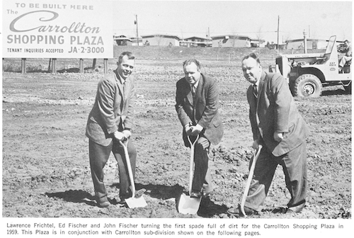
Ground breaking for the Carrollton Shopping Plaza in 1959, click image for map
When “Johnny Came Marching Home” at the close of World War II, he found one thing to his advantage, prosperity and jobs, and one disadvantage, a tremendous shortage of housing. For many returning GI’s and their prides, their first home was a rented room or shared quarters with their in-laws.
The building industry, stopped by the priorities of war, was turned loose, and developers looked to the suburbs for the land they needed to build homes. There was land, lots of land, and many home builders built square little box-like homes marching in soldierly fashion down square little streets. These houses sold as fast as they could be completed since young marrieds and young families were desperate for adequate housing.
With the convenience of the automobile, no location in St. Louis County was too distant. Sub-division after sub-division sprung up and was quickly populated.
Out of this building frenzy, one team emerged with a visionary approach to suburbia. Ed and John Fischer, along with brother-in-law Lawrence Frichtel added a dimension to home building that won national acclaim for their firm, Fischer and Frichtel. Instead of building several blocks of homes in in regimented manner, they built a community.
The firm amassed a large tract of land in northwest St. Louis County and in 1956 opened Carrolton, a planned community with gently curving streets, cup-de-sacs and open space. Instead of one or two home models, they offered a variety so that every other home would not look the same. They did not utilize every square foot for homes –they planned areas for churches, schools and parks that were built and used as the population grew. To make the community as self-sufficient as possible, they constructed a small shopping center so that necessities of living could be purchased within walking distance. And to complete their community, they built a swimming pool and a large recreation building, bringing free-time activities practically to the front door of residents.
Carrollton had a mixture of award-winning homes–and it was a community that offered residents more than any other single housing development in the area at that time. It was planned to make living in the suburbs enjoyable for the entire family — and its departure from the conventional set the standards followed by other developers.
Fisher and Frichtel was probably the number one home-building firm of the post-war era — and the reason for its success was simply that it gave the grass-cutting, snow-shoveling, house-painting, leaf-burning, tree-pruning public a product that was both excellent in quality and different in setting. The firm has been recognized and published in every major magazine and newspaper relating to homes, neighborhoods and conventional living throughout the country. Unquestionably, these men and their organization represent and give tribute to the great spirit of St. Louis.
Self-sustaining? Walking distance to necessities? Yes, single-family homes on cul-de-sacs can be walkable. Well, at least they tried in 1956.
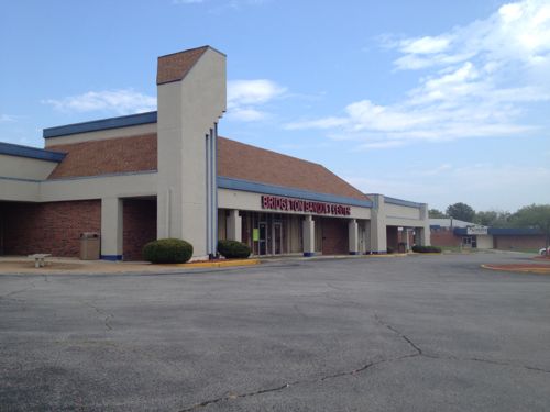
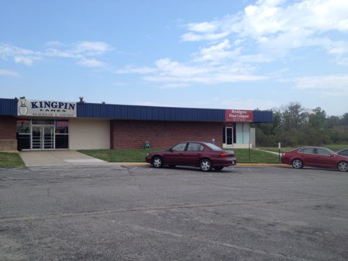
The original Carrollton Shopping Plaza has had face lifts since the early 60s and the neighborhood it served is now vacantThis bowling alley & retail space (now a pizza parlor) was built at the same time as the original Carrollton Shopping PlazaA couple of years later a Schnucks grocery store was added to the shopping centerThe sidewalks connecting the houses to the commercial remain. Though not ideal, or ADA-compliant, this was way better than most subdivisions of the 1950sIn 2005 Schnucks closed the Carrollton store and opened a bigger store on St. Charles Rock Rd at Lindbergh
However, decade after decade since Carrollton was platted, subdivisions have gotten progressively more hostile to pedestrians. I’m not sure how this happened, my guess is each subsequent generation got used to their environment and eventually only grandpa remembered walking to the store for milk.
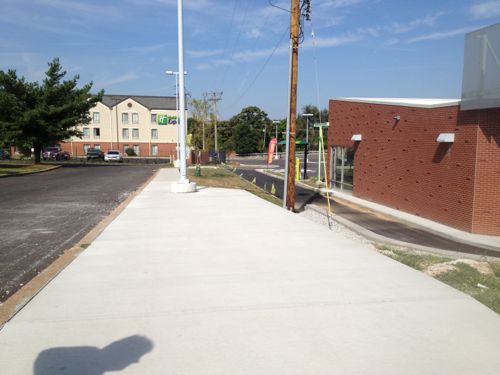
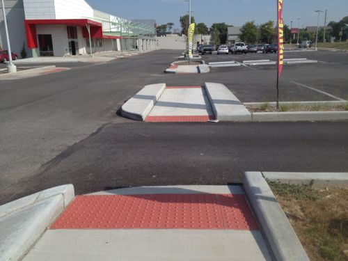
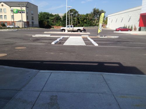
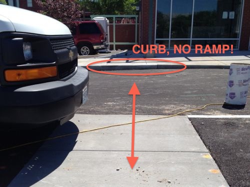
One of two newly created ADA access routes into Jefferson Commons, this is the south one.From this access route you can see the front of the newly constructed outlot building with two tenant spaces.Turning to the north at the bottom of the route you can see pedestrian access was given considerable thought.View from the new outlot building toward the ADA access routeBut approaching the building it was clear to me during construction in May one detail was overlooked, but I wanted to wait to see just in case something was planned. Last month the problem remained.
UIC/Greenstreet Properties did a great job and, as required by the ADA, provided a non-drivewalk access route from each public transit stop. Shopping centers must do so, whereas stand-alone properties can provide access through a driveway. Yet an important detail for compliance was overlooked. It may have been shown on the drawings but overlooked during construction, or left off the drawings by mistake.
I’ve not seen any crossing paint here, drawing that in on construction plans can greatly reduce a design or construction error. I’ll be sending this to my contacts at the companies responsible and to city officials.
Jefferson Avenue is a 5+ mile north-south arterial road in south, central, and north St. Louis (map). Along this stretch the road has 4-6 travel lanes, a center turn lane, and sometimes 2 parking lanes. What’s pretty consistent is the public right-of-way and curb to curb widths are excessively wide.
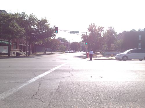
A female pedestrian makes her way across Jefferson at Russell
Here are some examples of the right-of-way width in locations you might be familiar:
Jefferson @ Russell: 120 feet
Lindell @ Euclid: 100 feet
Kingshighway @ Delmar: 100 feet
Grand @ Hardford: 80 feet
Chouteau @ Mississippi: 80 feet
Manchester @ Taylor: 70 feet
The above figures are from Sanborn Maps, mostly from 1909. Again, these are the public right-of-way (PROW), which includes the road and sidewalks. In an urban context this is measured from the face of a building to the face of the building on the opposite side. The road & sidewalk widths can vary within the PROW.
At Russell, Jefferson has a wider PROW than streets like Grand, Lindell, and yes — Kingshighway! This partly explains why Jefferson doesn’t have the same “feel” as South Grand. The wider the curb to curb, the faster traffic travels. The faster the traffic, the fewer the pedestrians. Fewer pedestrians & faster traffic means businesses will focus on customers in cars, not pedestrians. This reality conflicts with adjacent neighborhoods that seek a more urban environment, like McKinley Heights whose code required Family Dollar to build more urban than usual.
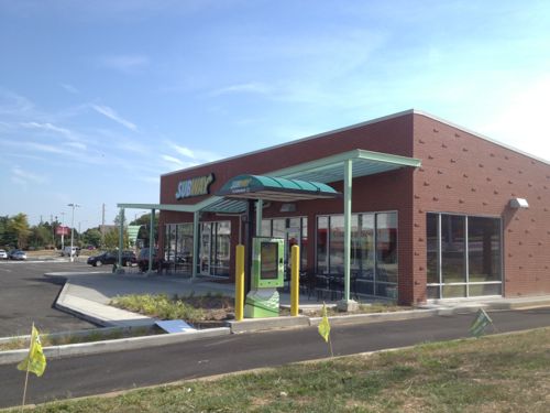
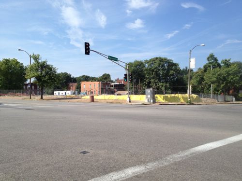
Construction of the new SouthSide Early Childhood Center is underway on the SE corner
Jefferson passes by many neighborhoods and political wards, with different ones on the east & west sides. With schools & residents on both sides crossing the street is important. Some intersections have pedestrian signals, others, like Russell, do not. The east side is the McKinley Heights neighborhood & 7th Ward while the west side is the Fox Park neighborhood and the 6th ward, such fragmentation makes it challenging to get projects done.
Hopefully enough residents from both neighborhoods can convince Phyllis Young (7) and Christine Ingrassia (6) to take a closer look at Jefferson Ave.
I’d like to see the following in the short-term:
Stripe Jefferson to just 4 travel lanes end to end
Include a solid white outside line separating the right travel lane from the parking lane as MoDOT did on Gravois
Add pedestrian signals with countdown timers at existing signalized intersections currently lacking pedestrian signals
Stripe crosswalks in the more visible “Continental” pattern
In the longer term I’d like to see:
A detailed corridor study looking at all transportation modes (car, bike, transit, pedestrian), development patterns & potential, etc
A charrette to look at designing a new streetscape.
In the coming weeks & months I’ll post more about problems & solutions for Jefferson Ave.
As a disabled person, my independence is very important. I assume no matter the disability. independence is important. Thus it isn’t a surprise to me to see it mentioned in mission a statement:
Yet their website illustrates auto-centric thinking, not independence:
The Society is located at the southeast corner of Brentwood Blvd. and Manchester Road. The corner of Brentwood and Manchester is approximately 2 miles south of the Galleria shopping mall. The Society’s facility is approximately 12 miles west of downtown St. Louis.
There are signs visible from all four directions at that corner indicating the “Society For The Blind Building”, with all addresses (8764 – 8798) of occupants of the building below the name. The Society’s entry is clearly marked above the main entrance.
There are reserved parking places in front of the main entrance, as well as handicapped parking next to the building.
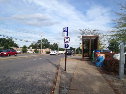
Where’s the information from public transit? I often encounter blind & visually impaired riders on transit.
The eastbound #57 MetroBus stops directly in front of their building on the SE corner of Manchester & Brentwood
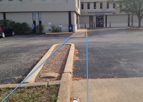
It would help their independence if the Society made a slight modification to provide an pedestrian access route separate from the auto driveway. It would be fairly straightforward:
Blue lines mark the ideal path an ADA access route would take
As you can see from the image above, building a pedestrian route would be a fairly simple proposition for them. I sent them a message a couple of days ago suggesting this. I’ll keep you posted if anything happens.
AARP Livibility Index
The Livability Index scores neighborhoods and communities across the U.S. for the services and amenities that impact your life the most
Built St. Louis
historic architecture of St. Louis, Missouri – mourning the losses, celebrating the survivors.
Geo St. Louis
a guide to geospatial data about the City of St. Louis