Home » Accessibility » Recent Articles:

Rethinking Interstate 64 (aka U.S. 40) In Midtown St. Louis, Between Compton & Grand

August 15, 2022 Accessibility, Featured, Midtown, Planning & Design, Transportation, Walkability Comments Off on Rethinking Interstate 64 (aka U.S. 40) In Midtown St. Louis, Between Compton & Grand

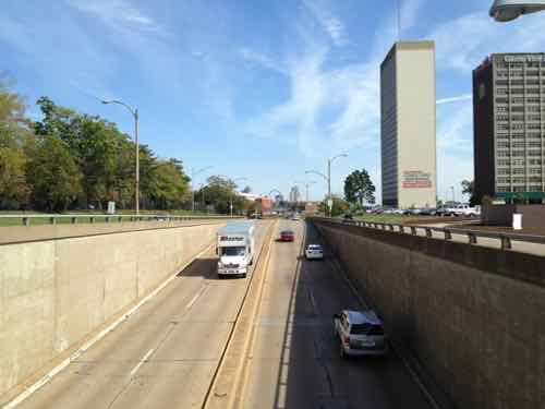
Regular readers know I have a strong dislike of the interstate highways that were forced through existing dense urban neighborhoods, destroying social networks and dividing neighborhoods. So it’s no surprise I’ve thought about I-64 in Midtown St. Louis for decades.
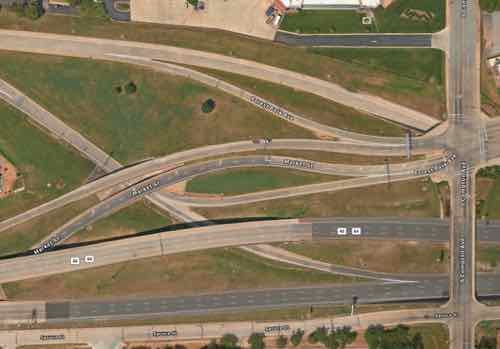
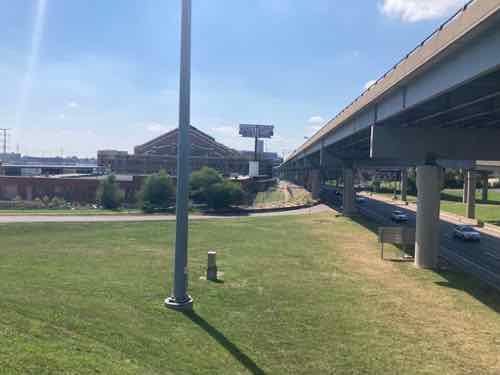
Aerial of the vast area immediately west of Compton. Source: Apple Maps. Click image to view area in Google Maps.

It was August 2021 when I learned MoDOT would be undertaking the huge task of rethinking the stretch of I-64 between Jefferson and Kingshighway.  Nine months later, in May 2022, the Future 64 planning project finally went public:

The I-64 Corridor between Kingshighway and Jefferson is an essential route for homes, schools, and businesses. The Missouri Department of Transportation (MoDOT) is working with the community to determine the future of the corridor in terms of needs and desired outcomes. Before MoDOT makes any improvements to the corridor corridor, it will evaluate the existing conditions of roadways, interchanges, surface streets, and bicycle/pedestrian access.   

The method the department is using is formally known as a Planning and Environmental Linkages study or PEL. This PEL study will look at the potential impact future projects will have on the environment, the community, and connectivity in the area. MoDOT is conducting the PEL now so when funding is identified for corridor projects, construction can begin sooner.

The PEL study for the I-64 central corridor is called: Future64: Community. Transportation. Together. The title reflects the importance of public engagement and community involvement in this process. As a result, this study will incorporate ongoing engagement that is equitable and inclusive to help ensure that a wide range and extensive number of voices are heard, and that equity is the focus of proposed solutions. (MoDOT/Future64)

Typically MoDOT doesn’t take the time to rethink, they just replace what was there. Example: the South Broadway bridge over I-44 downtown being replaced without any pedestrian sidewalk (see This Is Our Chance To Reconnect Two Neighborhoods Long Separated By Highways).

So this planning effort is an important milestone.

After the project went public some immediately began posting their ideas, but I’m a little slower in both my analysis and presentation.  Now, a year after I began thinking about specifics, I’m ready to share what I’ve come up with — and why.

First we need to look back at what the area looked like pre-interstate. In February 1909 if you were heading west on Market and reached Jefferson the main road bent to the left but became Laclede. Market west of Jefferson was a minor residential street. Between Beaumont & Leffingwell the road split again, with Laclede continuing ahead and Manchester off to the left. To repeat: Market briefly became Laclede, which split off to Manchester at a diagonal. Yes, Manchester used to run at a diagonal heading through what later became known as Mill Creek Valley toward downtown.
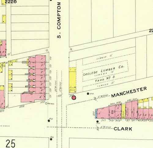
From the February 1909 Sanborn map we see Manchester, not Market, intersecting with Compton. Click image to see the full page view on the University of Missouri digital library website.

Go ahead, look at a map and visually draw a line between Manchester & Vandeventer and Compton & Market. Because of the many rail lines Manchester wouldn’t have been a straight line, it would have bent to the north of them. My point is a century ago streets continued uninterrupted, but highways/interstates (and industrialization) radically altered the landscape to make life easier for those behind the wheel of those noisy new horseless carriages (shaking cane). It’s possible the Manchester  connection was severed prior to the highway but I didn’t want to further delay this post while searching the Post-Dispatch archives for the answer.

It’s a given that I-64/U.S. 40 will not be removed, or buried in a big dig. What is happening now will determine how it looks and functions for the next 50-70 years. Next we need to list and look at what I see as the problems to solve by changing how the highway and interchanges are currently configured.

  • Large amount of land used, wasted
  • Pedestrian & bicycle navigation of area is challenging, nearly impossible, the local street network decimated
  • Driving the area is also challenging, with awkward & confusing on/off ramps
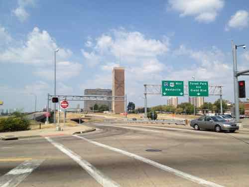
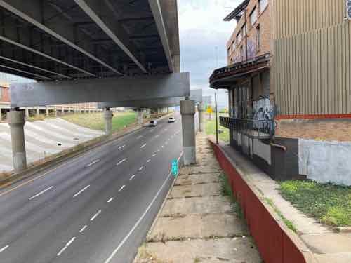
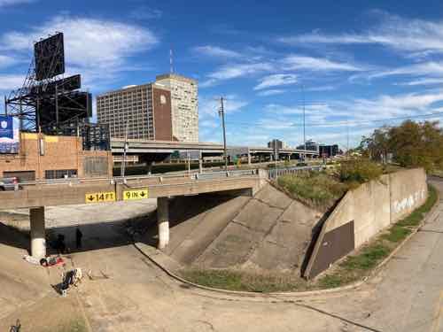
Looking west northwest from Compton & Spruce…if only I had a drone to get video/aerial photos
The Grand exit from eastbound I-64 may have made since in the 1950s/60s but not today
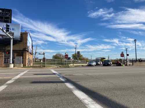
After a right right turn back drivers that exited eastbound I-64 are facing west at Grand

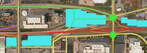
Okay, here’s my proposed solution.

Below I’ll look at this in two sections. Click image to view larger version.

Key:

  • Yellow: existing streets
  • Green: new or revised streets
  • Red: interstate
  • Purple: existing ramp
  • Orange: new on/off ramps
  • Light blue:

Let’s start on the left/west side.
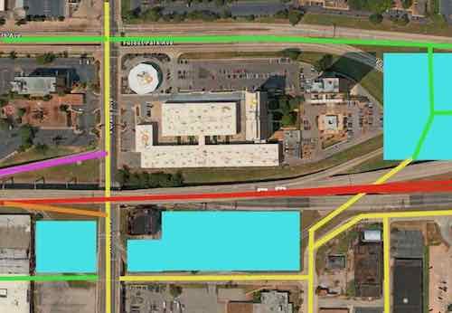
The biggest change from the left is the awkward existing Grand exit from eastbound I-64 has been replaced by a more conventional ramp. Drivers would be going up as they exited, but that would help them slow down. With the current ramp gone the building right at Grand & I-64 could be incorporated into a new development on reclaimed land. I’d also bring Forest Park Ave up to grade at Grand for a more conventional intersection.
The new exit would come up to Grand, the light could be moved. If the elevated section is completely replaced it would make this easier. The new eastbound exit would be similar to the one at 14th — just up instead of down.
Removing the current exit would free up a lot of land that can be used for new construction near the Grand MetroLink station and the heavily used #70 Grand MetroBus.
With Forest Park ducking under Grand the intersection on top is awkward for drivers, bicyclists, and pedestrians. As with Forest Park & Kingshighway, this intersection needs to be at grade and conventional.

Ok, lets move down to the big area to the east.
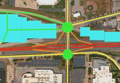
It makes sense to continue to allow interstate drivers in both directions an exit in this area. but it can be accomplished in a far more compact manner.  Specifics below.

The two green circles are roundabouts. Market Street could continue into the center of the newly developed area. Ideally 5+ story building would be built as a terminus to the view when heading west on Market. A new north-south connection through the new development would allow access to Spruce Street and the other parts south of I-64. The eastbound lanes of I-64 would need to be shifted north to give room for the on/off ramps at roundabout at Compton & Spruce. The westbound lanes of I-64 can shift south to free up land for development.

I’m not a traffic/civil engineer so I might not have sufficient room for say acceleration/deceleration on on/off ramps or some other detail, but I think this accomplishes the job of fixing the current problems. It gives more room for development, and increases connections for all modes of travel.

I’d love to see the new development include a variety of residential price points from low income to top market rates, parking available at a rate of less than one space per dwelling unit. It shouldn’t all be expensive housing geared toward college students. Other uses include office, retail, small manufacturing, perhaps business incubator space, etc.

I don’t know that I’ll live long enough to see any changes, but hopefully these ideas will be helpful to the process.

— Steve Patterson
 

MetroLink Escalators “Temporarily Closed” For Years

April 18, 2022 Accessibility, Downtown, Featured, Public Transit, Transportation Comments Off on MetroLink Escalators “Temporarily Closed” For Years

Escalators are great, very helpful to those who find stairs difficult.  However, like elevators, they’re expensive to install and maintain. Escalators exposed to the elements are even more challenging to keep in operation.

When our original light rail line opened in 1993 two stations were located within an old freight tunnel under the central business district (CBD). The Convention Center and 8th & Pine stations were designed with stairs, elevators, and escalators. Because the tunnel is narrow the tracks are in the center, the passenger platforms are on both sides — one per direction of travel, east or west. This meant a total of four elevators and four pairs of escalators — all exposed to elements to a degree.

When the Shrewsbury (Blue) expansion line opened in 2006 its three underground stations had stairs, elevators/ramps — no escalators.

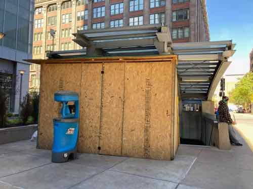
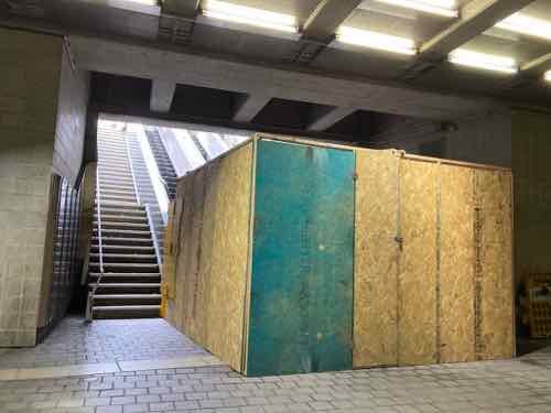
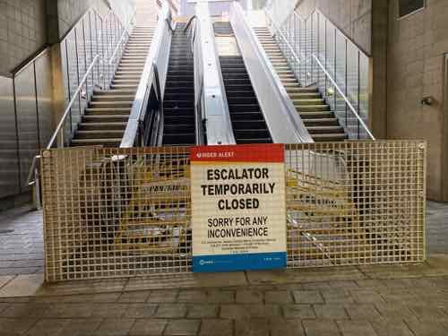
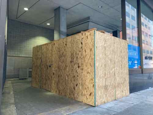
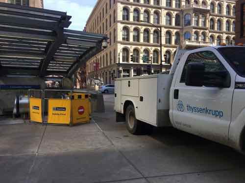
In 2018 & 2019 I’d frequently see ThyssenKrupp maintenance people working on the Convention Center escalators, or at least their service truck on the public sidewalk near the westbound entrance/exit. April 1, 2019
Here’s the same location on November 2, 2020
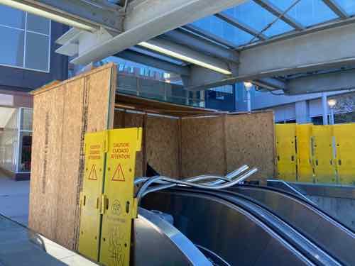
Another view, with parts visible. November 2, 2020
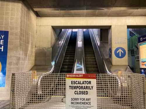
View from the platform level. November 2, 2020
The big plywood barricade has been gone for quite a while, but the escalators remain out of service. March 7, 2022
The eastbound escalators at 8th & Pine have been a similar story. Note access to the elevator is on the right, back — between the escalators and stair. April 21, 2021.
The street entrance of the eastbound 8th & Pine station after the plywood construction barricade was constructed, steps & elevator are accessible. March 1, 2022

I search all Metro press releases from 2019 through the present, only one mentioned escalators in the subject/summary.

From May 3, 2021:

Rehabilitation work on the westbound escalator at the 8th & Pine MetroLink Station in downtown St. Louis begins on Tuesday, May 4. During this project, the station’s westbound elevator will remain in service, however, the accessible pathway to the westbound side of the 8th & Pine Station (near Pine Street) will have to be closed temporarily.

MetroLink riders who are traveling to or from the 8th & Pine Station and use a wheelchair or mobility device may need to make adjustments to their commute, as it will be necessary for riders to use stairs (located near Chestnut Street) when entering or departing the westbound side of the 8th & Pine Station.

The escalator rehabilitation work is expected to take approximately three months to complete. (Source: Metro)

The above press release was issued a week after I followed up with Metro again since I hadn’t received any specifics from my inquiry on December 28, 2020. Receipt of my original inquiry was acknowledged but I never received anything. Just the one press release, above.

Since I use my power wheelchair when using transit why do I care if the escalators aren’t working?

Well, it looks bad to have something temporarily non-functional for days, weeks, months..years.

What do I hope to accomplish with this post?  I want all the escalators either in good working condition — or I want them removed and replaced with fixed stairs (I can’t speak to concerns of those who have a hard time with stairs). It obviously won’t happen quickly, but steady progress needs to be demonstrated.

It looks very bad for visitors to see out of service signs, but it’s even worse when returning visitors say “oh yeah they were out the last two years I’ve visited.”

— Steve Patterson


8th Street Walkway Needed To Fill Missing 110’ Connectivity Gap

March 14, 2022 Accessibility, Featured, North City, Walkability Comments Off on 8th Street Walkway Needed To Fill Missing 110’ Connectivity Gap

When cold water flats and tenements were cleared just north of downtown for St. Louis’ first high-rise public housing project, Cochran Gardens, several blocks of 8th Street were erased from the grid. Six decades later 8th Street was rebuilt* when the mixed-income Cambridge Heights apartments & townhouses replaced Cochran Gardens’ towers.

* 110 feet of 8th Street wasn’t replaced!

This short missing piece is a connectivity problem for those of us who live here. Later, when Cass Ave over I-44 (aka I-70) was raised as part of the Stan Musial Veterans Memorial Bridge project 7th Street got disconnected from Cass Ave. So now neither 7th or 8th connect to Cass. Getting to/from the bus at Cass Ave & Broadway is likely the primary reason for needing access here, it would also be nice when we go to Shady Jack’s or walk/roll up Broadway.

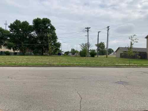
A little bit of the original 8th Street exists south of Cass Ave, but it quickly ends at an alley. Jersey barriers exist to keep drivers from going straight ahead.
From the broken sidewalk on the east side of 8th you can see a clear route to 8th Street 100 feet further south. The west side of 8th, unfortunately, has no sidewalk.
In the field you can see beyond Dickson Street to 8th Street
At the public sidewalk you can look south along 8th Street to downtown. 8th Street is the center of Cambridge Heights.

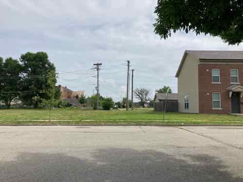
Motorists use the alley south of Cass to get to/from Cass Ave, but pedestrians often walk though vacant land where 110 feet of 8th street should be. As you’ll see, putting in street, curbs, drainage, etc would be challenging & costly — all that’s needed is a 110 foot long sidewalk and a couple of curb ramps.

Looking toward Cass Ave from the SW corner of 8th & Dickson streets.
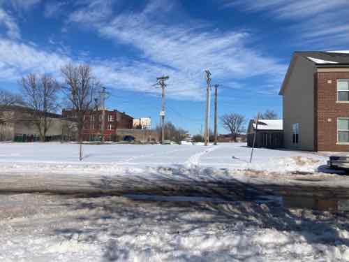
The same view after a recent snowfall. Two desire lines where people walked are clear. A community center is visible on the left, but no good way to get there directly.

This is needed because going between the neighborhood and Cass Ave is challenging as a pedestrian. I’ve thought so for the 3+ years I’ve lived here. I’ve also seen a woman at least 15 years my senior (so 70+) walking though the grass with a cane. The trail through the snow earlier this year was also a clue.

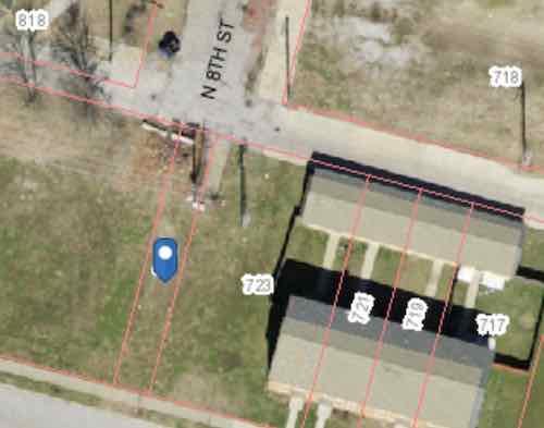
You might be thinking this land is vacant do it can be developed for more housing. Let’s take a look at the property lines.

The blue dot marks a 15 foot wide parcel owned by the St. Louis Housing Authority (725 Dickson Street). They also own the land from here to 9th Street. 723 Dickson Street is 64.26 feet wide, includes the 22 foot wide end of 3 townhouses.

My assumption is the 15 foot wide parcel known as 725 Dickson (map) is there to prevent anyone building over utilities, like sewer, under the old 8th Street. The end row house has a lot of extra land beyond their fence. Basically there’s more than enough width to create a generous pedestrian path. There are some obstacles near the alley.

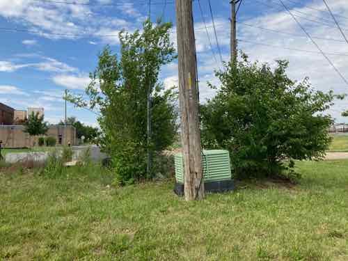
From the alley you can see a little bit of concrete and some useless chain link. And an electric utility pole.
From the lot you can see the pole and an electrical box (transformer?). There are also wires to help keep the pole upright on the private land side.

There’s room to fit a 5′ wide walkway at the alley to then toward 8th & Dickson streets, we just need to figure out property lines, utilities, easements, etc. City mowers have a hard time during the summer keeping the back area cut — a private home owner would get a violation letter from the city for such conditions. The elevation is slightly higher at the alley than south at Dickson Street.

The need exists, much of the land is owned by the housing authority. Cost wouldn’t be that substantial. I’d love to see fruit trees planed on both sides of a walkway so the public can access free fruit.

— Steve Patterson
 

Last Mile to Cahokia Mounds Is Impossible For Pedestrians

September 27, 2021 Accessibility, Featured, Metro East, Walkability Comments Off on Last Mile to Cahokia Mounds Is Impossible For Pedestrians

I’ve working on my bucket list in the last two years living with stage IV kidney cancer. Right after Memorial Day I was able to visit Milwaukee, my very first time in Wisconsin. I’m also working on items closer to home that I can safely do during a pandemic. To help me I pulled the 2013 book 100 Things To Do In Saint Louis Before You Die off my bookshelf.  One of several books written or co-authored by my longtime friend Amanda Doyle.

Well, I don’t see myself being able to physically sled down Art Hill, or use a paddle boat in Forest Park. Hmm, visit Cahokia Mounds? I’ve always wanted to see it, it’s likely the only additional  World Heritage site I’ll be able to visit — I’ve been to Independence Hall & many Frank Lloyd Wright buildings, including Fallingwater.

Embarrassingly in my 31+ years living in St. Louis I must admit I’ve never once visited Cahokia Mounds, a World Heritage site only a 15-minute drive into Illinois from St. Louis. Like so many places I thought I could go  &  things I could do in the future, until I became disabled a month before my 41st birthday. I had lived here less than 18 years before I had a massive stroke, meaning I couldn’t walk around the large Cahokia Mounds site. My power wheelchair allows me to “walk” around places like the Missouri Botanical Gardens.

In case you’re unfamiliar with Cahokia Mounds:

The remains of the most sophisticated prehistoric native civilization north of Mexico are preserved at Cahokia Mounds State Historic Site. Within the 2,200-acre tract, located a few miles west of Collinsville, Illinois, lie the archaeological remnants of the central section of the ancient settlement that is today known as Cahokia. (Cahokia Mounds Museum Society)

The fastest way there is for me and my husband to just drive there. But, I couldn’t see much because I can’t walk far. I also have a manual wheelchair we can put in the trunk, but he’d have to push me or I use my right foot and right hand to propel myself. One of us would get worn out.

I’ve traveled to five different states using transit and my power wheelchair so I should be able to go less than 10 miles. So I looked. Yes, I can roll 8/10 of a mile to the Convention Center MetroLink light rail station, take the train east to the Emerson Park station, and then catch the #18 Madison County bus northbound to Fairmont Ave at Collinsville Rd. Then it’s just a mile west along Collinsville Rd to the entrance to Cahokia Mounds State Historic Site (map).

A mile isn’t an issue at all, a week ago I rolled almost 5 miles home from Siteman Cancer Center. Yes, returning home on MetroLink would’ve been considerably faster but I got to see a lot of stuff along my route. I’m on disability so I’m usually not in a hurry. So what’s the problem?

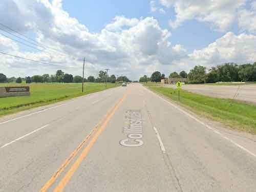
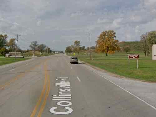
The problem is Collinsville Road is a high-speed (45mph) 4-lane roadway with zero pedestrian infrastructure. None. No pedestrian signals or crosswalks at the signalized intersection near the bus stop. A few businesses near the intersection have a public sidewalk but they’re not connected to each other. Most of the mile distance is just a very tiny shoulder and a ditch. If I were somehow to make it I’d need to cross Collinsville Rd. Opposite the entrance to Cahokia Mounds is a pedestrian sign, but trying to cross 4 lanes of high-speed traffic is a death wish.

Approaching Cahokia Mounds from the east you see it on the left. On the right is a pedestrian crossing ahead sign, next to the ditch.
Further up as you get close to the entrance the road splits so there’s a center turn lane. On the right is a Cahokia Mounds sign pointing drivers left. The driveway to the right has a culvert under it so any water in the ditch can continue to flow.

My thoughts turned to contacting someone to bug them about this. But who? Most of the north side of Collinsville Rd is in Namioki Township, Madison County. Part of the south side of Collinsville Rd & Cahokia Mounds are in Collinsville, St. Clair County. Yes, most of Collinsville is in Madison County, but this part is in St. Clair County. And finally  the the intersection of Collinsville Rd & Fairmont Ave/Black Lane is State Park Place, an unincorporated community in both Madison & St  Clair Counties. Maddening fragmentation!

I suppose an able-bodied person could navigate this last mile, but I doubt anyone would.  Back at State Park Place there’s business on both sides of Collinsville Rd, including a Mexican restaurant on each side. I read somewhere a while ago that one is among the best Mexican restaurants in the Metro East.

My first task will be to contact Cahokia Mounds to see if they have any power wheelchairs/scooters for rent, their website doesn’t mention accessibility at all. I’ll also contact the Highway Dept at each county, though it might take state and/or federal funds to get anything built. I just want to get things…rolling.

Steve Patterson


St. Louis County Moved Mandatory Beg Button After I Complained About Not Being Able To Reach It

September 10, 2020 Accessibility, Featured, Planning & Design, St. Louis County, Walkability Comments Off on St. Louis County Moved Mandatory Beg Button After I Complained About Not Being Able To Reach It

Buttons used to activate pedestrian signals are derisively called “beg buttons.”

These buttons have long been decried and criticized by advocates for walking, anyway. The buttons’ purpose is less to keep people safe than to reinforce the primacy of cars on the street by forcing people who want to cross a street to “beg” for a walk signal. (California Streetsblog)

In the City of St. Louis many buttons don’t do anything, a walk signal is displayed even if you don’t press it. In June I encountered an intersection in St. Louis County where it was mandatory to press a button to get a walk signal across one street, but not the perpendicular street from the same corner.

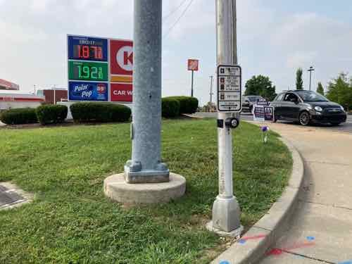
On June 3rd I was at the southeast corner of Hanley & Dale Ave, wanting to cross Hanley — but using a wheelchair I couldn’t get to the button.
Looking west across Hanley.

Crossing Dale Ave doesn’t require pressing the beg button, it activates the walk signal in conjunction with the traffic lights. However, if you don’t press the button you’ll never get a walk signal to cross Hanley. Even when Dale traffic gets a green light you’ve got a don’t walk unless you pressed the beg button. Without a walk signal westbound Dale motorists turning left onto southbound Hanley wouldn’t expect to see any pedestrians crossing the street. On June 3rd I had to cross, in my power wheelchair, even though I didn’t have a walk signal.

Thankfully left-turning motorists yielded to me.  I later shared my frustration on Facebook, Instagram, and Twitter.

A friend & reader suggested I call St. Louis County. Though this is in the municipality of Richmond Heights, Hanley is maintained by St. Louis County — a fact she knew. I’m not a fan of making voice calls but I did find a compliant form on their Department of Transportation website. A day or 2 later I got a phone call from a county engineer. I emailed him the photos I took rather than call him back. A few weeks later I got an email saying it had been moved.

Yesterday I went out to the nearby  Trader Joe’s  and another store so I went to this intersection to see the change. I’d suggested the button(s) not be used, just switch to a walk signal timed with the light. So I figured the beg button would still be mandatory, I just wanted to see if I could reach it.

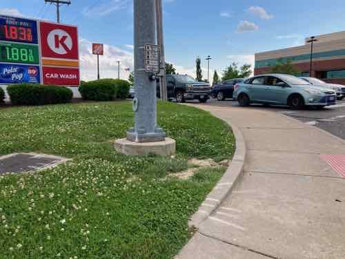
A pole was added to hold the two beg buttons — one mandatory and the other completely useless.
Now looking west across Hanley.

No telling how many years this was like this. It amazes me how often I see situations where someone wasn’t thinking about disabled pedestrians. There are likely many more examples out there.

— Steve Patterson
 

Advertisement


[custom-facebook-feed]

Archives

Categories

Advertisement


Subscribe