I considered using today’s topic for a Sunday Poll but decided it was too technical to get a good response. My original plan was to ask for the ideal clear width next to the pull side of a door.
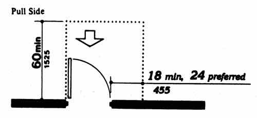
ADA diagram
Here’s the text description of the above diagram:
Plan view drawing showing the clear floor space adjacent to a hinged door. Door swings out into the clear floor space. An arrow indicates a forward approach to the door on the pull side.
Clear floor space is shown with a dotted line. The clear floor space extends 60 inches minimum from the door (closed position). The clear floor space width is the door width plus 18 inches minimum (24 preferred). A minimum of 18 inches clear space (24 inches preferred) is provided adjacent to the edge of the door (latch side) on the pull side.
My thought is many, likely the architects, would’ve selected 18″ instead of options like 0″, 6″ 12″, or 24″. This is because the bare minimum number (18″) has become so well known, the preferred/ideal of 24″ gets lost. The 18″ minimum is just that — a minimum — not ideal. Less than 18″ and many wheelchair users are unable to open the door. With the m,minimum of 18″ I find myself having to rub against the baseboard/wall to get into position to open the door.
Why bring this up? The architect/designer of the hotel we stayed at in Oklahoma City was confused. The Days Inn at 122nd & I-35 is an older hotel that later added another 2-story building in what was originally an oversized parking lot.
Both entrances to the newer building containing their rooms for the disabled had zero to the side of the pull side of the door. Really?
Our room also wasn’t as ADA-compliant as you might expect for a disabled room: the bathroom door handle was a knob rather than a lever. The shower wasn’t roll-in as listed — it was a standard shower base. I was able to use it ok but others I know wouldn’t be able to shower. I’ve submitted a complaint to Days Inn about the design.
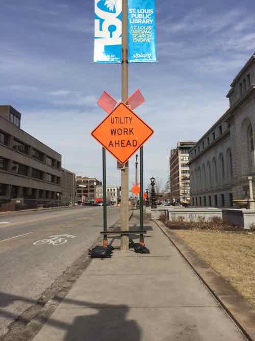
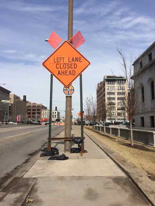
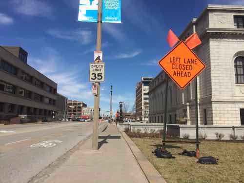
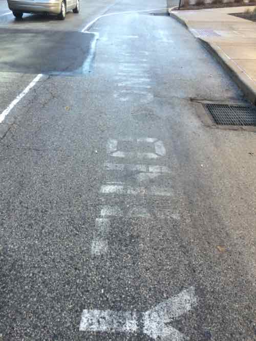
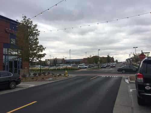
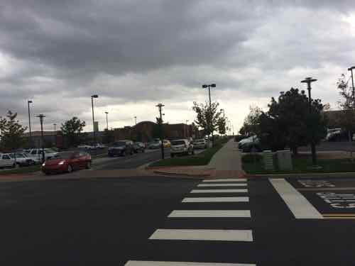
Recently, while taking 14th Street, I noticed construction signs limiting the width of the too-narrow public sidewalk — the East side between Olive & Locust — adjacent to the main library.
Looking North from Olive you see the first sign on the sidewalk. Behind it is another on the sidewalk and a third in the grass to the right of the sidewalk.This is the 2nd sign on the sidewalk, a bus stop served by five MetroBus routes is just beyond
I posted one image to Facebook & Twitter with the caption: “14th street sidewalk almost completely blocked by temp road sign #ADA” A response on Twitter suggested I tweet this to the CSB (aka Citizens Service Bureau). Instead I emailed two people at the Streets Dept, copying two from the Office on the Disabled. Streets quickly identified the culprit — hired contractor Intren — working for Ameren.
The two signs on the sidewalk were reduced to one on the grass.The 3rd sign that was always on the grass –likely because they didn’t want to cover/block the fire hydrant.
Temporary signs are a necessity, but so is the sidewalk next to the main library used by 5 MetroBus routes. The sidewalk is too narrow for the pedestrian volume but the historic library landscaping and the street width prevents it from being widened. Once again, people unaware/unconcerned about pedestrians.
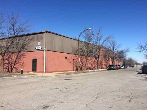
We can all agree St. Louis must retain existing employers and attract new ones. Unfortunately, St. Louis has a habit of forgetting about urban design along the way. Let’s take a look two examples; one within the proposed 100 acres site for the National Geospatial-Intelligence Agency and one to the immediate West.
First is a warehouse currently occupied by Faultless Healthcare Linen.
This warehouse, built in 1991, will be razed if the National Geospatial-Intelligence Agency picks the city site over three others in the region.This small building from 1899 helps hide the awful warehouse behind it.
I remember when this was built in 1991 — I’d just moved to Old North St. Louis and passed it daily on Jefferson. One street was closed, the rest are faced with blank concrete block walls.
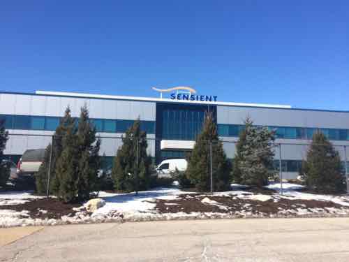
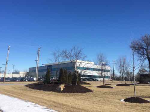
The next example is Pharmaceutical company Sensient Colors Inc., their 30-acre campus at 2515 N. Jefferson is to the West of the potential National Geospatial-Intelligence Agency site.
The newest Sensient building was built in 2004 faces Jefferson but no entrance here, no public sidewalks even.Looking NE from Elliot Ave between N. Market & Benton. The company has removed many public sidewalks from the public-right-of-way adjacent to their facility.
Never heard of Sensient? I hadn’t either, but you’ve likely seen their products — on your plate.
Most of the world’s largest food and beverage manufacturers use Sensient colors and flavors to make their household brand-name food and beverage products. (St. Louis Business Journal)
Now, the demand for natural colors is suddenly outpacing demand for synthetics, and Sensient, which makes both, is responding. It has sophisticated technology it won’t explain (it does mention doing “supercritical CO2 extraction”) to pull the coloring agents from botanicals. It has a Fusion Precise Natural Color system that lets customers specify not just a particular color, but also a subtle shade of that color. And it has a head start: 60 years’ experience with natural colors. (St. Louis Magazine)
I get it, they have trade secrets. Still, in a city people do walk to work — especially from public transit. I believe we can retain/attract employers without turning our city into a suburban office park.
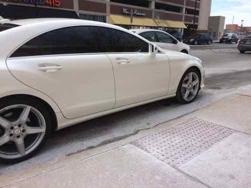
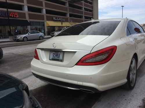
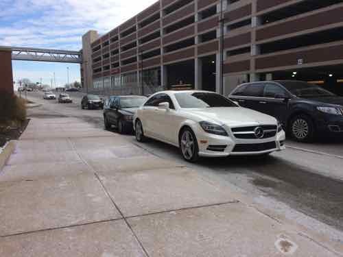
Since I started this blog more than a decade ago pedestrian access & walkability have been a regular theme — especially since I became disabled 7 years ago. Friday I encountered a car parked blocking a ramp. Being a car guy I tend to mention the make of car — it was a Pontiac that blocked a ramp on one of my first outings to the store in a wheelchair in 2008. The car on Friday happened to be a Mercedes.
I said “Mercedes owner blocked a crosswalk I needed at Richmond Hts MetroLink station” on Facebook & Twitter. Click to view on Facebook.I posted this picture of the rear vanity license plate “SCHMUK” on Twitter and in the comments on Facebook, click to view on Twitter.No license plate displayed on the front — as required by Missouri law. No snow or ice — just salt residue
I’m posting this to start a civil discussion about the physical design of the area and how pedestrian amenities are easily ignored.
These three images, above, were taken at 12:11-12:12pm on Friday afternoon, it was 43 °F just before noon. Like everyone, I make mistakes. When I do I admit as much.
Here’s what I got wrong:
The ramp isn’t for a crosswalk, it’s for a passenger loading zone.
It’s near the Brentwood MetroLink Station, not the Richmond Heights MetroLink Station — that’s located one station Eastbound on the Blue Line, which opened in 2006.
Very little discussion on Twitter, but Facebook erupted. Here’s some comments that remained as of yesterday (users deleted others):
Comments from a 23 year-old saying he’s the owner:
Thanks facebookers. This is actually my vehicle. I assure you that it was a clearly marked parking space and a car was actually parked behind me as you can see. The curbs are not marked yellow or anything. I apologize but it says nothing about not parking in that space. My plates are hilarious I know. Thanks dan for telling me about the post! Lets find something new to complain about now!
[After I said I contacted the police] “Omg. Like they don’t have more important stuff to worry about. Sorry you had an inconvenience. Again. The writing on the pavement was still covered in snow and ice.. Also why isn’t the other car being put on a blast? Because it was not a Mercedes!”
Only tacky people use front license plates. Duh.
God my car is beautiful though isn’t it?!
I have apologized multiple times. No clear signs. No curb markers. No lines within the area. Also the other car hasn’t been called out. Just mine. I’m over the whole situation.
From his friends:
I find this city to be wasting more and more time on pointless endeavors that literally amount to nothing more than pessimistic chatter.
Go fight a war, go feed the homeless, save a child refugee…no chance of you becoming something of use to the world because you will all still be on facebook making a fool out of yourselves and the right of freedom of speech. No wonder this city is in turmoil… people being shot over petty crimes and people bitching about where cars are parked on a social media site during their off time. #sillyfirstworldproblems My finger tips were cut off a month ago. THAT is a problem. …get a life.
It’s the principle. I also am annoyed that my friend who is a very kind, successful individual who doesn’t deserve internet slander or harassment was being targeted as som e sort of criminal. It is as I said before petty, a waste of time, and pathetic.
You guys are clearly uneducated morons! Had any of you spent as much time trying to be successful as you do running your mouths and posting stupid stuff on fb, you too could have nice things. Maybe then you wouldn’t have to run your mouth and judge ppl just to fill you free time it looks like a perfectly fine place to park to me!
Wow! Pretty sure anyone who can afford a Mercedes can most definitely read! So you’re a wannabe photographer, I wouldn’t quit your day job just yet. Parking sucks all over stl & I’m sure that loading zone was so clear thru the ice that even you missed it! You even said so. I am truly nowhere near wealthy & even I have more to do in life than to be so dang petty over something so minimal! Josh is a wonderful person, I’ve known him his whole life! But you all see a Mercedes & automatically go to rich jerk….stereotype much! Sorry, I just think it’s ridiculous to waste this much time of your day venting about something when it would’ve taken 5 extra seconds to walk around the car a foot! They’re not going to give you a Jay walking ticket if there’s obviously a vehicle blocking what you THOUGHT was a crosswalk. Get a life…one where you have a legitimate reason to bash someone, for more than having money bcuz your attitude says that’s all your pissed about. Love ya Josh, glad you could handle this with the class you did, sorry, couldn’t shut my mouth when it’s about my adopted brother!
Wow. I know my friend would never intentionally try to hurt anyone or do wrong, as I’ve known him for eight years. Mistakes happen, and whether or not he parked incorrectly, I don’t think it warrants such persecution. He didn’t get a ticket, did he? Leave the law up to the police, not the Internet.
I love that the fact you’re driving a Mercedes is what is really pissing people off, [redacted]. If you were driving a POS (that’s Piece Of Shit, for you flipping idiots out there), no one would have even posted about this as that shit happens all the time! Find something else to be pissed about people. #youarethespoiledone.
How about using your anger to get the city to install signs on poles that would clearly state Loading zone. Not paint a street that would be covered with salt residue. do something useful instead of petty with your time.
His Dad removed his comments, but the one from his mom remains:
My son has apologized, he is a very caring and loving young man and has always obeyed the law, once again, we apologize for all the inconvenience. Loving Mother
One of his so-called apologies was this internet meme:
Some may consider this an apology, I do not.
Another comment from the thread — from a personal friend:
I understand that it does not alway occur to people that parking in front of the sidewalk ramp prevents someone using a wheelchair from crossing the street– it is a concept that most folks have the luxury of not thinking about. The benefit of this thread is that it has had the potential to increase awareness (for those open to having their awareness increased). However, I don’t think “sorry you are poor” and related sorry-not-sorry apologies count as a sincere apology and referring to “inconvenience” is patronizing.
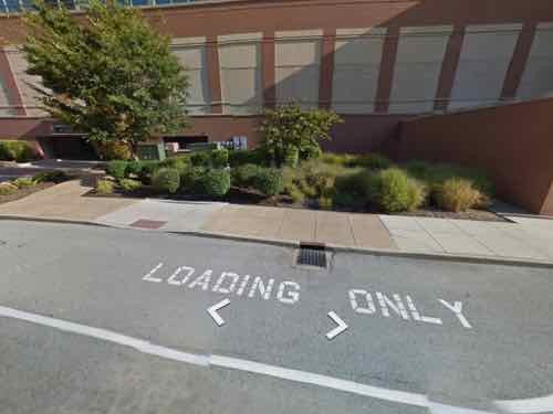
Friday I wanted to verify what another commenter had said — that it was clearly a loading zone on Google Maps. The aerial was too dark but the August 2012 Street View was clear, I shared the following screen shot in the thread.
In the comments I was accused of photoshopping the words LOADING ONLY even though I included a link to see it on Google — click to view. I couldn’t photoshop the above, much less hack Google.
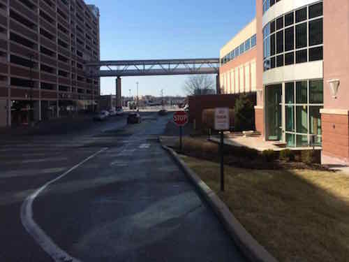
We were out that way Sunday afternoon so I drove through to check it out from a motorists prospective.
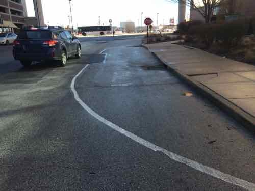
Right off Hanley you see a loading only zone with a solid white line and a sign. He was parked further West, let’s see how it looks.Again, a solid white line that curves back to the curb is a good clue this isn’t for driving or parking. The text is faded and no sign is posted like the previous spot. The ramp is very visible,A close up of the fading text, but the solid white line and ramp are pretty clear.
This entire development is poorly designed — it doesn’t work well for both motorists and pedestrians. After the I-64 rebuild Musick Memorial Dr became a public street, it’s how you get to Westbound Eager Rd from Hanley. From the various comments I got the view that everything East of I-270 is “the city”, with what the rest of us know as the city being downtown. St. Louis has no responsibility for Musick Memorial Dr — that falls to either the developer or City of Brentwood.
If only there was a massive parking garage where he could’ve parked.
I’m a huge fan of Retrofitting Suburbia, the redevelopment of formerly auto-centric suburban retail sites. In late September, while on my honeymoon, I got to see three different examples in the Denver area. Two site once had traditional enclosed malls, the third was previously an airport. We started with the oldest and finished with the newest.
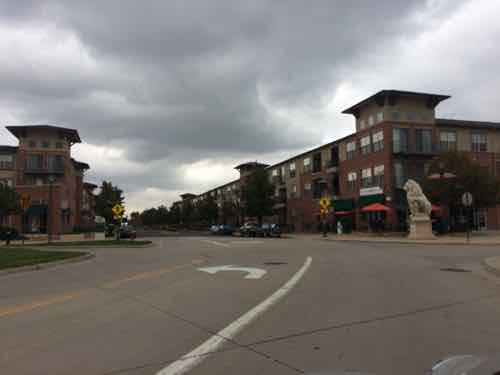
Englewood, CO
In June 2000 the CityCenter Englewood project opened, replacing Cinderella City mall that had opened just 32 years earlier:
The mall was completed and officially opened for business on 7 March 1968 and once held the distinction of being the largest covered shopping center west of the Mississippi River. It featured four sections: Rose Mall, Gold Mall, Shamrock Mall and Cinder Alley. In addition, the Center Court area was known as the Blue Mall. It was demolished in 1999. (Wikipedia)
Englewood was founded in the 19th Century but largely developed in the Post-WWII era. Like many post-war suburbs, it lacked a downtown. By the 1980s newer malls had eclipsed Cinderella City. In the late 1990s they saw the replacement of the mall and the coming of light rail as an opportunity to build a downtown:
CityCenter Englewood replaced Cinderella City with a transit-oriented development (TOD). This TOD is a pedestrian-friendly, mixed-use concept that includes retail, entertainment, residential, office, civic and open space elements with a transit focal point. The former Foley’s building was renovated into the new Englewood Civic Center, which houses the City Hall offices, the Library, Municipal Court, and the Museum of Outdoor Arts. The Civic Center was the first feature of CityCenter Englewood to open when it made its debut in June 2000.
The Civic Center creates the cornerstone of the redevelopment of Cinderella City that includes Wal-Mart, Trammell Crow apartments with first floor retail, Office Depot, the Sports Authority, IHOP, Qdoba, and other retail and commercial businesses, second floor office with first floor retail, an RTD light rail station, and a Bally’s Fitness Center. (City of Englewood)
You can see a current aerial here, and a 1991 aerial here. In the Southwest corner of the site an anchor store building was retained, as was part of the structured parking. The adjacent street grid was brought through the site. Apartments were added nearest the new light rail station, big box stores added to the east end of the site. All connected by a grid of streets and sidewalks.
The former anchor store that remained is nope the Englewood Civic CenterThe light rail station is to the left, the Walmart down the road to the right. Yes, a Walmart is across the street from a large 3-story apartment building that has street-level retail.
Not bad for an early example of such a project. We saw people walking as we drove through, others can be seen in Google Street View.
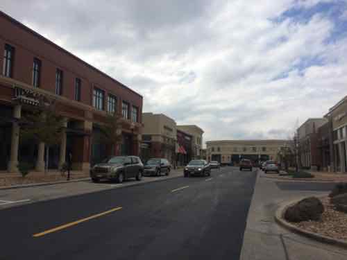
Lakewood, CO
The Villa Italia mall opened two years before Cinderella City, in 1966. By the 1990s Lakewood officials saw both malls dying off, they didn’t want a vacant mall in their city.
A referendum was held in 1997, which authorized “urban renewal” to redevelop Villa Italia into a more conventional downtown district, something that the post-war suburb had never had.
In 1998, Lakewood entered into a joint venture with Denver-based Continuum Development. Continuum purchased the land beneath the mall from the Bonfils-Stanton Foundation in September 1999 and acquired the buildings and ground leases from Equitable in early 2001. The site was rezoned (from that of an enclosed shopping center to a mixed-use development) and the redevelopment plan put in motion.
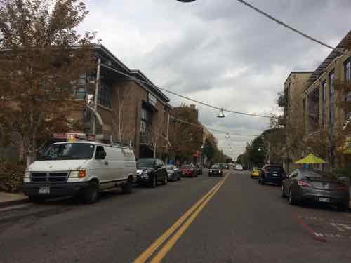
Villa Italia closed in July 2001, demolition began the following January. Belmar opened in 2004. Like CityCenter Englewood, streets were cut through the site. Not private driveways, public streets with public sidewalks. The pedestrian grid was as equally important as the vehicular grid, not an afterthought.
You can view an old aerial here and a current one here.
A new street at BelmarThe new buildings have a variety of uses and architectural stylesIt too has big boxes, this is the side view of Target.
A former anchor department store building was kept, it’s now a Dick’s Sporting Goods store. New housing is on the perimeter of the site, surrounding the retail core.
Stapleton
When Denver decided to build a new airport east of the developed region the question became what to do with the old airport.
b
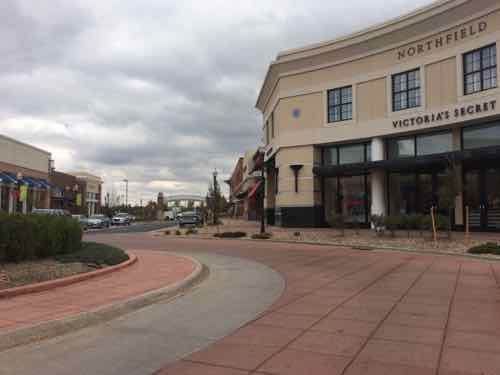
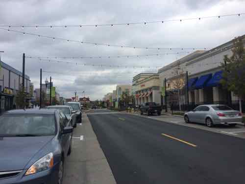
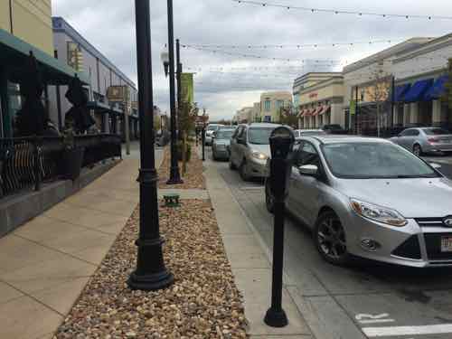
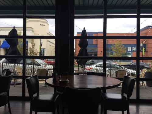
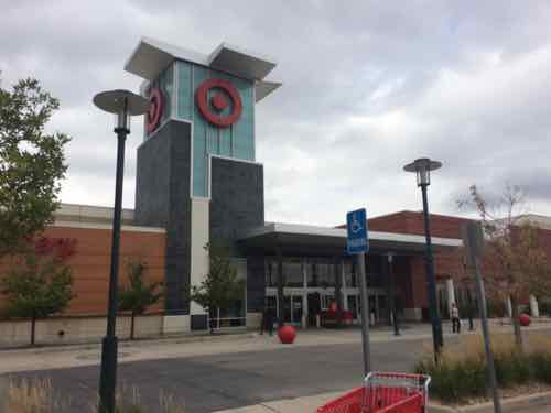
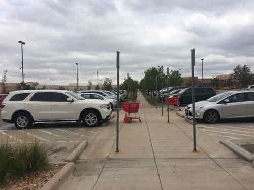
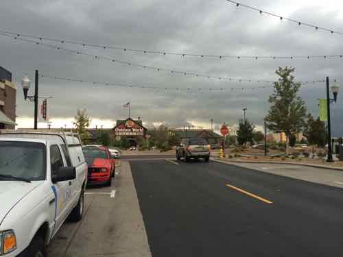
A wide variety of new housing is part of Stapleton, including single family homes, apartments, townhouses, etcAn internal street in the center of the main retail area called The Shops at Northfield StapletonAnother viewAnother street in the core of the retail area, note the on-street parkingDespite plenty of free parking on the perimeter, to park in the center requires payment. The silver Ford Focus was our rental for 3 days of our 7-day honeymoonLooking out at the street from our lunch tableJust beyond the center you can see big box stores and large parking lots.Like the two previous examples, pedestrian connectivity was planned from the start to connect everything together.The urban-ish area on the left, big box to the right. All walkable & drivable.Another view from the retail center looking toward the big boxes on the perimeter.Target is among the many big box stores at StapletonLooking out from Target, their walkway connects to the Stapleton pedestrian network beyond Target’s parking lot.The street where we parked terminated in a Bass Pro Shops store, also connected to the sidewalk system
The overall site is massive, as you might expect from a former airport. It has many residential neighborhoods, distinct retail areas, and a business park.
Final thoughts
All three are variations on the New Urbanist/Retrofitting Suburbia theme. While I wouldn’t want to live at any of the three I know someone like me, who uses a wheelchair often, can get to businesses at each development on a sidewalk network. All three remain very car friendly, I drove to all three. Providing the option to walk doesn’t make them less appealing to motorists. Some pedestrians probably arrived by car but decide to explore on foot rather than drive from store to store.
AARP Livibility Index
The Livability Index scores neighborhoods and communities across the U.S. for the services and amenities that impact your life the most
Built St. Louis
historic architecture of St. Louis, Missouri – mourning the losses, celebrating the survivors.
Geo St. Louis
a guide to geospatial data about the City of St. Louis