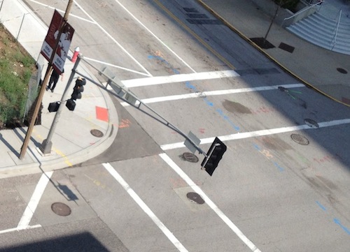
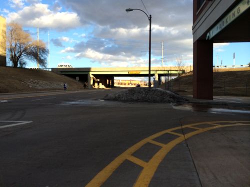
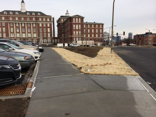
In July 2013 I noticed the perimeter of BPV wasn’t ADA-compliant. The single ramp is pointed sorta across Walnut, no ramp for crossing Broadway. This needs a “blended corner” due to high volumes of pedestrians on game days
On January 19th I noticed this corner looks a bit different:
The entire corner was busted out so it could be redone, hopefully correctly this time.
I’m not sure who screwed up originally but the fixes aren’t cheap. This is just another example of pedestrian work done poorly/incorrectly in St. Louis, with almost no oversight.
Eventually I hope the owners, contractors, architects, and engineers on these projects will learn how to do things right, or at least hire someone that does, to make sure they’ve got it right before the concrete is poured.
Yesterday I decided to use a gift card I had for Crate & Barrel. We’d had warmer weather and rain to help clear away the snow. Unfortunately I encountered a problem as I approached The Boulevard.
As I got to The Boulevard I found a massive pile of snow blocking the wheelchair ramp. 3:42pm on Monday January 13, 2014. High temp yesterday was 55 degrees.I had to turn around and go back to the MetroLink station to cross to the other side.I briefly thought I wouldn’t be ab;e to get through, I crossed mid-block. Crate & Barrel is on the left.After I made my purchase I got a pc of the other side of the snow pile blocking the most direct route.
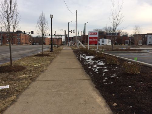
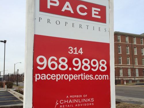
The Boulevard is owned by developer Pace Properties. Here’s how they market the development:
In the heart of St. Louis is a lifestyle destination unlike any other. The Boulevard – Saint Louis is a vibrant village with a unique blend of upscale retail, fine dining, and luxury residences. Home to retailers and restaurants such as Soft Surroundings, Loft, Crate & Barrel, P.F. Chang’s China Bistro and Maggiano’s Little Italy, The Boulevard is the premier lifestyle development in the St. Louis metropolitan area. Take a stroll down the shops of Main Street and sit back and relax on the patio of our restaurants. (The Boulevard)
“Vibrant village” huh? Right…. I shouldn’t be surprised since their “visit us” page gives driving directions, no mention of public transit.
As I was checking out at Crate & Barrel the clerk asked me how may day was going, I said “Great, but I had a hard time getting here.” I showed her the first picture above. She was shocked so she called the store manager over. I showed the manager the same picture and she said she’d talk to Pace Properties.
UPDATE: Response from Pace Properties received 1/14/14 @ 2:45pm:
Steve:
As property manager of The Boulevard Saint Louis, I am sorry to hear about your recent experience. Pace Properties takes accessibility issues very seriously. For example, at the Brentwood Square Shopping Center we recently did a large, and costly, project overlaying the parking lot and replacing the handicap ramps in front of each store to ensure that we had ADA compliant paths. Unfortunately, the mound of snow that restricted your path adjacent to The Boulevard was pushed there by the county when they were clearing Galleria Parkway. We do not have any surfaces in that vicinity that would necessitate snow clearing due to the covered garage – with the exception of the small entrance/exit to the garage and the sidewalk. I have spoken with our snow removal vendor and they have been instructed to clear future obstructions from the ADA accessible ramp.
Thanks for contacting us regarding this issue. We appreciate visitor feedback and hope that we can make your next visit a more enjoyable experience.
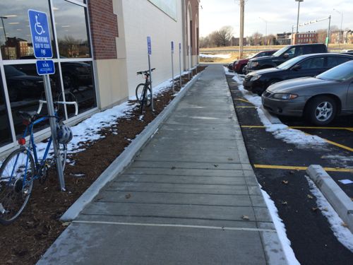
Late last month I posted about a blatant ADA violation at Fields Foods, which remains at this time. At the grand opening I noticed one thing they got right that most get wrong: detachable warnings.
The sidewalk leading to the disabled parking correctly lacks the truncated domes used as detachable warnings by the visually impaired. Bike racks are expected soon.
They got it right by not including detachable warnings? Yes, too often their use is misunderstood by architects & civil engineers:
Detectable warning surfaces consist of small truncated domes built in or applied to a walking surface that are detectable underfoot. On pedestrian access routes, detectable warning surfaces indicate the boundary between a pedestrian route and a vehicular route where there is a flush rather than a curbed connection for pedestrians who are blind or have low vision. The proposed guidelines require detectable warning surfaces to be installed on newly constructed and altered curb ramps and blended transitions at pedestrian street crossings. (Access Board)
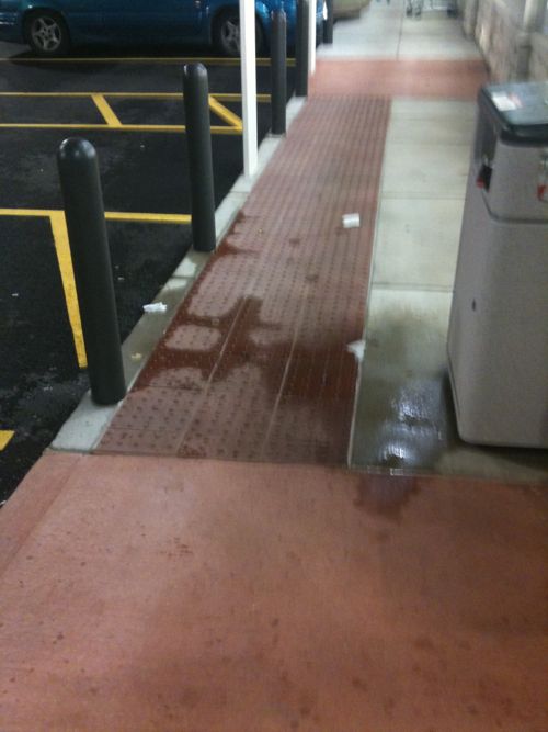
The “at pedestrian street crossings” part is what’s often overlooked, resulting in detectable warnings being used far too often. Here’s two recent examples:
The Walgreens across the parking lot did it all wrong by placing detachable warnings in front of the disabled parking spaces.Nearby Jefferson Commons also overdid the detectable warnings
You’re probably thinking, “So what?” These are used by the visually impaired to locate street crossings. They feel the truncated domes through their shoes to know the direction to walk to cross the street. The last two examples above are overkill.
Clearly there’s lots of confusion out there:
Q: Regarding detectable warnings, you use the word “street.” What about parking lots? And are drive islands [that separate driveways in parking garages or other parking lot structures] considered streets? I’ve also used them when trash enclosures are behind the sidewalk, at drive-thru lanes, and in parking lots where there’s a row of handicap parking spaces with zero-inch curbs. I place them at all places where you could get hit by a car.
A: There’s a reason for stating “street,” and that is to prevent overuse. Detectable warnings are for actual street crossings, with the small exception of commercial driveways with traffic control devices. (Public Works magazine)
These truncated domes aren’t cheap, or free to install. Developers are paying extra to create confusing environments for the visually impaired. Developers, architects, engineers, plan reviewers, etc. need to pay attention to this issue. Ideally they’d have an ADA/pedestrian expert on their design team to avoid these mistakes.
For 9+ years now I’ve written thousands of posts advocating for a better St. Louis. I know that getting developers to just meet the minimum requirements of our local building & zoning codes, the minimum guidelines of the American’s with Disabilities Act of 1990, etc. will not create great public & private spaces. That will, at best, make sure development won’t harm the public by collapse and not infringe the civil rights of the disabled.
To create great spaces it takes everyone (citizens, developers, business owners, architects, civil engineers, etc) looking at a site and thinking “what would make this great?” not, “what’s the least we can get away with?” We need a process in St. Louis to examine developments with respect to pedestrian access. If we did we’d see better connected projects — and more pedestrians. Let’s take Gravois Plaza as an example.
The old Gravois Plaza was razed and a new development built on the site, in December 2004 I wrote:
I’m in this area 2-3 times per week and I have always seen pedestrians taking this unfriendly route. I guess one could take the attitude that people are walking anyway so what is the big deal. However, the message to people is clear – if you don’t have a car we really don’t give a shit about you. Sure, we don’t mind if you walk here to spend your money but don’t expect us to go out of our way to do anything for you.
In the meantime the parking lot is way too big and has so few trees it is almost comical. How is it TIF financing can be used to finance a project that is closed to the neighborhood to the West & North, is anti-pedestrian and is mostly paving? Our city must not have any codes requiring a connection to the neighborhood, pedestrian access and even something so basic as a reasonable level of landscaping.
The old Gravois Plaza, for all its faults, was more accessible to neighbors to the North. People could enter at Potomac & Gustine and enter the courtyard space. So while the new Gravois Plaza is cleaner and features a nice Shop-N-Save store it is less pedestrian-friendly than the old Gravois Plaza.
So what would I have done you ask? Well, I would have destroyed the wall along Gustine and connected the development to the neighborhood by regrading the site. To achieve a true connection to the surrounding neighborhoods I would have divided the site back into separate blocks divided by public streets. Hydraulic Street, the South entrance along Gravois, would be cut through all the way North to Potomac Street. Oleatha & Miami streets would be cut though between Gustine on the West to Bamberger on the East. This, of course, is completely counter to conventional thinking about shopping areas.
With all these new streets plenty of on-street parking could have been provided. Several small parking lots could be provided as necessary. Arguably, less total parking could have been provided as you’d have more people willing to walk from the adjacent neighborhoods. Ideally, some new housing would have been provided above some of the retail stores. Big Box stores like the Shop-N-Save have been integrated into more urban shopping areas in other cities – it takes a willingness on the part of the city to show developers & retailers the way. The smaller stores would easily fit within a new street-grid development.
A substantial amount of money was spend rebuilding Gravois Plaza but the area is not really a part of the city. It is a suburban shopping center imposed upon the city. This could have been so much more.
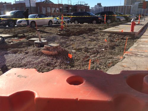
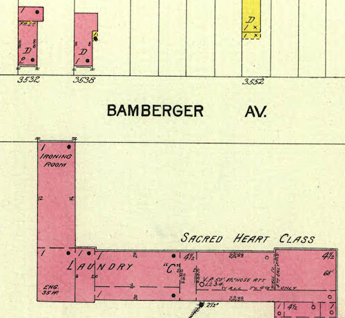
I now know the site never had cross streets, the Sisters of the Good Shepherd convent was built on 11 acres in 1895.
A 1903 Sanborn map shows the convent pre-dated much of the housing. Click image to view on the UM Digital LibraryWe can see the east wing extended all the way to the property line at Bamberger Ave., more connection than the two iterations of Gravois Plaza since
The original Gravois Plaza, built in 1971, didn’t consider pedestrians from the surrounding neighbors or via bus on Gravois. Thirty years later the same mistake was repeated when the site was cleared and rebuilt. In 2001/2002 we knew better but with no formal policy on pedestrian access the new project got financial help to take place.
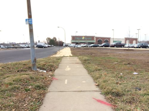
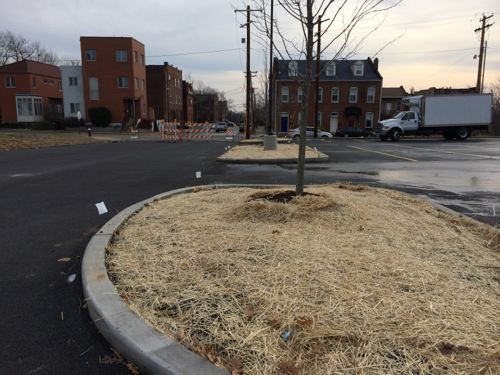
A pedestrian policy would require an analysis of pedestrian access points and a pedestrian circulation plan. Of the five buildings on the site of the convent only one, the Wendy’s built in 2010, connects to the sidewalk. None connect to each other.
The ADA route from the public sidewalk to the suburban-style Wendy’s
Some people, those who champion the lowest common denominator, seem to think everyone drives everywhere. They’ll point to awful anti-pedestrian areas and say “See, I told you nobody walks here.” They ignore the path worn in the grass of pedestrians finding their way to their destinations. People walk, especially to buy groceries, even if the environment isn’t designed for walking.
We live in a city where many use public transit and walk daily, why not design new development to accommodate them as well as the motorist?
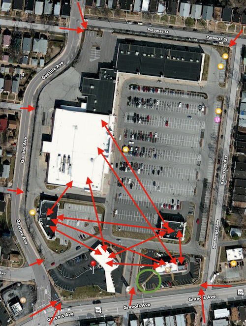
The red arrows are how pedestrians access the site and needed internal connections. The green circle is the walkway to Wendy’s. Original image: Apple Maps, click to view in Google Maps.
It starts when a site is targeted for development. It might be an old industrial site or a place that’s been vacant for decades, so no pedestrian traffic exists. But the point of new development is to attract people — to jobs and retail services. Some will walk.
Questions to ask at the start:
What direction(s) will pedestrians come from to reach the site? Can we anticipate more pedestrisns at some arrival points versus others?
Will the site have more than one building when fully built out? How will each be reached from outside the site and from each other?
Can we make the design pleasant enough that people walk to the site rather than drive, allowing for a reduction in the amount of surface parking needed?
Can we arrange the building(s) so those who arrive via car to park and walk from store to store?
Can planter areas next to the pedestrian route(s) be used to catch & retain storm runoff?
It costs little, does no harm, to ask these questions at the earliest stages of a project. Asked later and the answer is likely to costly to make changes. Never asking them risks a ADA discrimination complaint.
We can build better developments that are welcoming to everyone, and don’t need a new government incentives to be razed and replaced 10-30 years later!
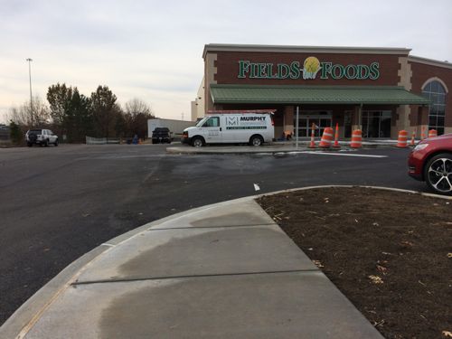
In early November I visited the site of a new grocery store opening on January 4th, Fields Foods. I was disappointed with respect to pedestrian access:
I’m very glad to see the store nearing completion. It’ll provide needed jobs, though jobs may be lost elsewhere as people change where they buy groceries. Sadly, it doesn’t appear any consideration to the many who will arrive daily on foot, some pushing strollers, and even the occasional wheelchair user. <snip>
Hopefully, somehow, I’ll be proven wrong when the grocery store opens January 4th.
I visited again last Thursday, and with the site work done I can say it isn’t what I expected: it’s both better and worse!
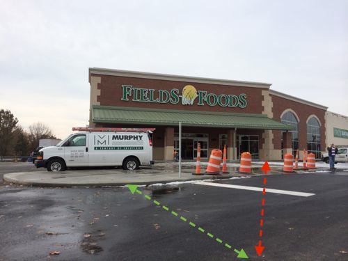
A new walkway connects to the public sidewalk along Lafayete, something I didn’t see on my prior site visit. Could I have been wrong, is this a proper ADA-compliant access route?Unfortunately this walkway is only for the able-bodied because at the end there isn’t a curb ramp, nor one across the drivewayThe non-ADA walkway seen from the driveway looking back toward 14th & LafayetteThe green line represents what would be a logical point for a crosswalk, the red line is the route wheelchair users, like myself, will be forced to use after entering via the main automobile drive, formerly 14th Street. This is a major conflict with cars.The sidewalk remains from when 14th was a public street. Pedestrians entering via 14th will have to walk in the grass since the sidewalk wasn’t continued. A BSI employee confirmed the concrete work was complete, the rest of this area will be grass or plantings.Anyone thinking about pedestrian access would’ve connected to the 14th & Lafayette intersection.The able-bodied not pushing a stroller or walking with a small child, and approaching from the west, will likely cut through the parking lot (right) rather than use the walkway where the red sign is located.As I previously noted, no provisions are provided for pedestrians to the east. St. Louis has or will be vacating Soulard St between 13th and the former 14thThe ADA also requires a pedestrian route between buildings within the same development, which wasn’t considered here at all. Another building(s) is planned for the land bounded by Lafayete, 13th, Soulard (former), and 14th (former).Not sure who’s a fault for the failure to comply with the spirit and letter of the ADA: owner, architect, contractor?Or perhaps the master developer is to blame? My guess is a combination of all of these as well as the City of St. Louis. Pace is the developer behind the proposed Midtown Station and served as IKEA’s commercial broker
Last Thursday I contacted several St. Louis officials to alert them to the issues I discovered. I suggested they withhold the occupancy permit until the walkway is retrofitted to be ADA-compliant with a curb ramp, crosswalk, and curb ramp on the building side. Providing pedestrian access not accessible to all is a very clear ADA violation. I gave my card to the BSI employee I talked to last week, he said he’d give it to the owner. I’ve not heard back from anyone.
It would’ve been fairly easy to design & build this to be highly accessible/walkable from all directions, new construction shouldn’t need to be retrofitted. When the city is vacating public streets pedestrian access from that direction should be provided.
The parties involved in the project are collectively incompetent with respect to pedestrian access. The ADA is more than grab bars in the bathroom. I’ll be there on January 4th to see if the situation is improved.
— Steve Patterson
UPDATE 12/23/2013 @ 9:45am — I just talked with Fields Foods owner Chris Goodson, he said workers are correcting the situation. The sidewalk shown wasn’t part of the original design, it was added after the fact after my November post.
AARP Livibility Index
The Livability Index scores neighborhoods and communities across the U.S. for the services and amenities that impact your life the most
Built St. Louis
historic architecture of St. Louis, Missouri – mourning the losses, celebrating the survivors.
Geo St. Louis
a guide to geospatial data about the City of St. Louis