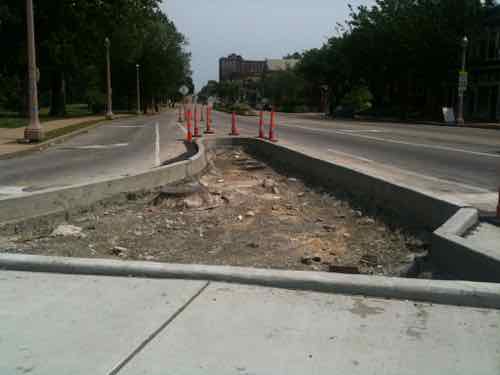
A few years ago a few blocks of South Grand underwent a road diet:
In 2009, South Grand Boulevard was selected as one of four Great Streets Initiative pilot projects in the St. Louis region. Since 2006, East-West Gateway Council of Governments (EWG) has been helping communities in the St. Louis region expand the way they think about streets. Local leaders and citizens are encouraged to think beyond the curb to understand how transportation decisions affect the total built environment.
EWG recognizes the importance of streets as community resources and through the St. Louis Great Streets Initiative intends to make them more than just a conduit for cars. Great Streets in St. Louis will emphasize all modes of travel, especially walking. Great Streets will address and reconsider the auto- centric approach that has dominated design over the years in order to transform these streets into great community resources.
Considering how street design choices affect the pedestrian realm and abutting land uses is central to the St. Louis Great Streets Initiative. Connecting communities requires more than just installing a sidewalk along the edge of a busy street. It requires the careful and intentional creation of an environment that suits walking, bicycling and transit. It requires taming traffic in a way that still allows for mobility, but at speeds that are safe and undamaging. Streets traverse through communities and should do so in a way that enhances the community. (PDF — large file)
Now that the project has been completed I wanted to know how readers felt about it.
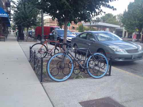
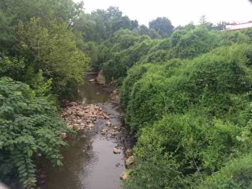
Generously wide amenity zone on the new Grand South Grand, September 2013Looking North on Grand from Arsenal as construction began, May 2011
Q: Now that it has been in place a few years, what is your opinion of the South Grand ‘Great Streets’ road diet:
Highly favorable 18 [45%]
Favorable 12 [30%]
Neutral 4 [10%]
Tie 3 [7.5%]
Unfavorable
Highly unfavorable
Unsure/No Answer 0 [0%]
As you can see, 75% have a positive view with only 15% a negative. I voted for “favorable”, some design decisions kept me from voting “highly favorable.” The pedestrian path still seems too narrow, for example.
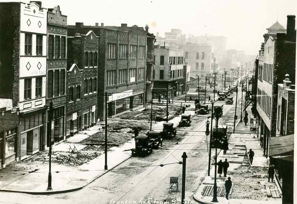
Fronts of buildings cut off to make room to widen Franklin Ave, looking East from 9th, 1928. Collection of the Landmarks Association of St Louis
We need more of these road diets to counter the massive road widening projects of the early 20th century! We have nowhere near the population that existed in those days, the road widening that took place is part of the reason for our population decline. We must remake our streets on the scale of a century ago — making them suitable for all modes (pedestrian, cyclist, motorist).
Please vote in the poll, located in the right sidebar
Today’s poll topic comes as a result of a recent discussion with a friend on Facebook over South Grand’s streetscape project. I’ve heard differing views from others as well, so it seemed like a great poll topic.
The exact question is: “Now that it has been in place a few years, what is your opinion of the South Grand ‘Great Streets’ road diet:”
The poll, open until 8pm, is at the top of the right sidebar. The answers are provided in random order.
We all know the phrase: “Don’t look a gift horse in the mouth.” Those living in low-income areas, especially those of color, have been sent this message for decades: Mill Creek Valley, Pruitt-Igoe, etc. In other words, we know what’s best for you so just accept what we decide to give to you. In the near term the gifts seemed like a good idea, but in hindsight they were ill-conceived and corners were cut. Pruitt-Igoe:
As completed in 1955, Pruitt–Igoe consisted of 33 11-story apartment buildings on a 57-acre (23 ha) site, on St. Louis’s lower north side. The complex totaled 2,870 apartments, one of the largest in the country. The apartments were deliberately small, with undersized kitchen appliances. “Skip-stop” elevators stopped only at the first, fourth, seventh, and tenth floors, forcing residents to use stairs in an attempt to lessen congestion. The same “anchor floors” were equipped with large communal corridors, laundry rooms, communal rooms and garbage chutes.
Despite federal cost-cutting regulations, Pruitt–Igoe initially cost $36 million, 60% above national average for public housing. Conservatives attributed cost overruns to inflated unionized labor wages and the steamfitters union influence that led to installation of an expensive heating system; overruns on the heating system caused a chain of arbitrary cost cuts in other vital parts of the building.
Nevertheless, Pruitt–Igoe was initially seen as a breakthrough in urban renewal. Residents considered it to be “an oasis in the desert” compared to the extremely poor quality of housing they had occupied previously, and considered it to be safe. Some referred to the apartments as “poor man’s penthouses”.
Despite poor build quality, material suppliers cited Pruitt–Igoe in their advertisements, capitalizing on the national exposure of the project.
The people were expected to adapt to the solution, rather than the solution adapt to the people. Locally and nationally little has changed since the 1950s.
Early residents were thankful, those displaced not so much. Within a decade what had seemed like a great solution turned out to be an expensive nightmare. Most of the site remains vacant four decades after being cleared.
The players today are different — non-profits and the private sector in place of the federal government. The attitude, however, is the same: ‘we want to do something to help you — why should we ask for your input?’ The unintended consequences of the well-intentioned were huge. Eventually the federally government realized the folly of this way of thinking — changing to rules & regulations to require environmental impact studies, public input, etc. This is not to suggest these will avert all unintended consequences — they won’t — but the results are better than those designed in isolation. Which brings me to Ferguson.
As I wrote about a week ago two community plans intersect at former ferguson QuikTrip site. Rather than QuikTrip officials quietly talking with the St. Louis Urban League for six months I think they should’ve empowered the local residents by getting them involved in the process of determining what to do with the site. The Urban League’s slogan is “Empowering Communities. Changing Lives.”
This was an opportunity for Ferguson’s residents to have a say in their future — to have a seat at the table. Empowerment through engagement.
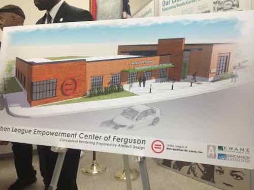
Rendering of the Empowerment Center of Ferguson shown on March 16, 2015
The speakers for their presentation was exclusively top-down players:
Michael P. McMillan President and CEO, Urban League of Metropolitan St. Louis
Michael Johnson Board of Directors, QuikTrip Corporation
Warner Baxter Chairman, President & CEO, Ameren
Patrick J. Sly Executive Vice President, Emerson
Thomas J. Irwin Executive Director, Civic Progress
Kathleen T. Osborn Executive Director, Regional Business Council
Susan Trautman Executive Director, Great Rivers Greenway
Steven Sullivan President and Executive Director, Provident
The proposed new building would be built in the same spot as the old QuikTrip — not up to the sidewalk to make the area more pedestrian-friendly as suggested by the Great Streets Initiative. Great Rivers Greenway said they’d hire some who complete the 4-week jobs 101 course to be Gateway Rangers to bike the North Riverfront Trail — the planned trail next to the site wasn’t mentioned.
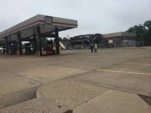
Today’s buildings are more disposable than those build 100 year or more years ago, this QuikTrip opened in 1989 — it lasted 25 years until burned following the shooting of Michael Brown. As I said in the comments on Monday, the building had been fully depreciated. Yes, the St. Louis County Assessor still said it had value, but the business view is different — for tax purposes you want deductions: a facility you can depreciate or lease payments.
QuikTrip just razed their 2851 Gravois location built in 1991 — to be rebuilt. QuikTrip sold this property two years ago in a 15-year sale leaseback. The two-year older Ferguson location wasn’t sold to an investor, so no deductions. The 1.14 acre site was too small to build a new QuikTrip. So they opened a new location a mile and a half north at 10768 W. Florissant Ave. on 3+ acres.
It was either the night of the shooting, August 9th, or the next night when the older QuikTrip was burned that QuikTrip Board Member Michael Johnson called the Urban League’s Michael McMillan to offer to donate the property. I can’t blame them — they probably had wanted to close the location anyway. So began the six month process involving corporate CEOs and heavy hitters collectives like Civic Progress.
A few misunderstood my point a week ago — involving the public or at least respecting the plans the public helped draft — isn’t an “either or” situation. They could’ve done exactly as they did but announced this building will represent the new W. Florissant Ave with a up to the sidewalk design to respond to the needs of the high pedestrian population. Instead they just decided to put the new building where the old building was.
The building was located on the East edge of the site, set back from W. Florissant and Northwinds Estate DriveQuikTrip never made added an accessible route to the entrance, as required by the ADAThe North side is the easiest to meet the one route minimum, but most pedestrians will come from W, Florissant.
Locating the building at the street corner would make access from the sidewalk easy. Keeping the building at the back will require a circuitous route(s) — not pedestrian-friendly. Bare minimum — not empowering!
Additionally, if the Urban League builds at the back of the lot behind parking it’ll be difficult to convince others along W. Florissant Ave to rebuild in an urban manner — effectively killing an important part of the plan. The St. Louis region is known for developing plans that sit on the shelf and collect dust — now we’re killing plans through willful ignorance.
When I asked during the press conference about why the building wasn’t up to the sidewalk Mike McMillian, said “remediation.” I guess that means QuikTrip isn’t remediating the contamination enough to build over the old tank location, but even that doesn’t make sense. To remediate the site enough for residential use would be onerous — but a commercial building should be able to be constructed after the tanks are removed and basic remediation has been completed. I think they simply failed to consider the pedestrian population of Ferguson.
Nothing is built yet — the site isn’t ready yet. I hope they’ll do the right thing and work to set a good example for future buildings this stretch of W. Florissant.
Before Michael Brown was shot & killed last August, community planning had been completed to improve parts of Ferguson & neighboring municipalities. In 2011 Great Rivers Greenway District completed the Maline Greenway Concept Plan, in June 2014 East-West Gateway Council of Governments completed the West Florissant Avenue Great Streets Master Plan — both included extensive community participation along their linear boundaries.
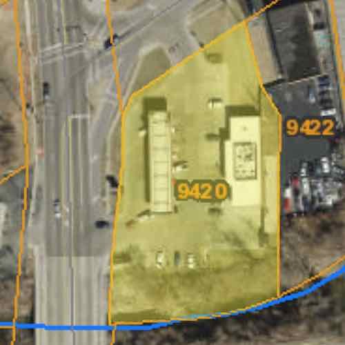
The boundaries of each plan, coincidentally, intersect at the burnt out QuikTrip (9420 W. Florissant Ave). The 1.14 acre site, on W. Florissant Ave, is bordered by Maline Creek on the South. Next week I’ll post about the Urban League’s intentions for this site and how they ignored two published plans with extensive community involvement. Today more detail on both plans.
The Vision for West Florissant Avenue comes from community and stakeholder input received through multi-faceted outreach efforts. These have included public workshops and virtual walking tours, interviews with community leaders, input from the Community Committee and Technical Advisory Committee, an Agency workshop, and an online survey and mapping tool. The Vision Statement has distilled this community and stakeholder input, with the most significant community values expressed as how the corridor should look, feel, and contribute to the community’s future.
The Maline Greenway Concept plan presents the findings of a yearlong planning process that involved inventory, analysis and recommendations. Input from residents within communities along the greenway helped shape the plan. The report includes background information on the District, summary of existing conditions, review of public input, description of the Maline Greenway concept, implementation overview and a summary of recommendations that include not only the trail alignment opportunities but also recommendations that address the social, economic and environmental quality of life for the communities. The Concept Plan helps to guide partnership opportunities, provides an analysis of the corridor, identifies community connections and alignment opportunities.
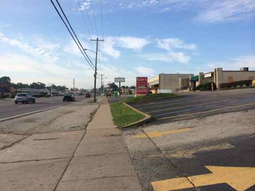
The West side of W. Florissant is very similar to the East. lots and lots of paving. August 2014
Ferguson’s zoning was updated as recently as 2011 and includes a downtown form-based code. Ferguson’s guiding comprehensive plan document is the Vision 2015 Plan Update that dates to 1998.
Page 24:
Although sidewalks are provided on both sides of West Florissant Avenue along most of the corridor, the pedestrian realm is generally uninviting and often unsafe. Buildings are spaced too far apart to walk, sidewalks are interrupted by frequent driveways and parking entries, and there are few pedestrian amenities or street trees.
Page 25 talks about transit and possible Bus Rapid Transit (BRT):
West Florissant also carries transit, specifically MetroBus Route 74 (Florissant line), and though the headways are long (30 minutes), Route 74 is one of Metro’s heaviest-used lines, with over 1.1 million boardings in 2013. West Florissant is crossed by MetroBus Route 61 (also in Metro’s top ten heaviest-used routes, with 800,000 boardings) at Chambers Road. The heavy transit use along the corridor results in a correspondingly heavy pedestrian demand. There is a clear opportunity to encourage transit- and pedestrian-oriented development at this intersection of West Florissant and Chambers Road.
While the current roadway configuration works relatively well for those traveling by automobile, and offers a transit option, other modes and users are largely shortchanged. West Florissant Avenue’s auto-dominated character and design, width, and traffic speeds, as well as the lack of any bicycle facilities, make it hostile to and unsafe for cyclists. Conditions for pedestrians are somewhat better, with the presence of sidewalks, but the pedestrian experience in many places along the corridor is unpleasant and unsafe.
With new high-quality transit service given priority along the corridor, and with rush-hour headways of 10 minutes, the opportunity exists to remake West Florissant Avenue into a transit-first street, with transit-oriented, pedestrian-scale development clustered around some key stations along the corridor. The corridor has a relatively wide right-of-way, which will make allocating space efficiently to serve the multi-modal needs of all its users easier than if the street were narrower.
New infill development should be guided by new zoning and guidelines that require buildings and entrances to be built up to the sidewalk, forming a consistent street wall. Until redevelopment occurs, individual property owners should be encouraged to beautify the edges of existing parking lots that front the avenue, so that the pedestrian experience is improved.
The study area of West Florissant Ave is long, but you have to start somewhere. From the Executive Summary:
Project construction should start at the south end, where there is high potential for redevelopment projects such as new housing, retail and mixed use projects. Thus investing public funds in this zone first follows a strategy that looks to catalyze private investment as soon as possible. Maline Creek is also planned to be reconstructed, so developers will be attracted to the critical mass of activity which will result in an appealing place for housing to be developed. Putting the South Gateway into construction in the first phase will also help create a rationale for the street design and use of medians and access management, simply because these street treatments are already in place immediately to the south, at Buzz-Westfall Plaza.
Maline Creek was identified as the point where the commercial development stops and residential begins, the former QuikTrip is on the residential side of Maline Creek.
Looking East at Maline Creek from West Florissant, the QT site on the left. August 2014
Numerous park and open space areas exist along the proposed Maline Creek corridor which could potentially function as trailheads and Greenway amenities. Creating attractive linkages between parks and open spaces will promote public use and create the opportunity for the greenway to become a regional attraction. (p1.5)
After the trail leaves Ferguson’s Forestwood Park
Continuing east, the trail is planned to be located in open space at the north side of Maline Creek to West Florissant Avenue. From West Florissant Avenue the trail is planned to proceed south across the creek and then go east on the south side of the creek for approximately 2000 feet. A pedestrian bridge is planned in this area to cross the Maline Creek to reach the north side open space and continue east to Lucas and Hunt Road near Westview Middle School (p1.9)
The QuikTrip site could, perhaps, allow the trail to stay on the North side of Maline Creek.
In the interest of transparency and community involvement I think the community should share in setting the vision for the use of 9420 W. Florissant Ave. More next week.
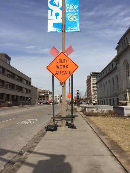
Recently, while taking 14th Street, I noticed construction signs limiting the width of the too-narrow public sidewalk — the East side between Olive & Locust — adjacent to the main library.
Looking North from Olive you see the first sign on the sidewalk. Behind it is another on the sidewalk and a third in the grass to the right of the sidewalk.This is the 2nd sign on the sidewalk, a bus stop served by five MetroBus routes is just beyond
I posted one image to Facebook & Twitter with the caption: “14th street sidewalk almost completely blocked by temp road sign #ADA” A response on Twitter suggested I tweet this to the CSB (aka Citizens Service Bureau). Instead I emailed two people at the Streets Dept, copying two from the Office on the Disabled. Streets quickly identified the culprit — hired contractor Intren — working for Ameren.
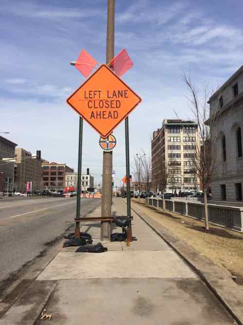
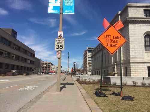
The two signs on the sidewalk were reduced to one on the grass.The 3rd sign that was always on the grass –likely because they didn’t want to cover/block the fire hydrant.
Temporary signs are a necessity, but so is the sidewalk next to the main library used by 5 MetroBus routes. The sidewalk is too narrow for the pedestrian volume but the historic library landscaping and the street width prevents it from being widened. Once again, people unaware/unconcerned about pedestrians.
AARP Livibility Index
The Livability Index scores neighborhoods and communities across the U.S. for the services and amenities that impact your life the most
Built St. Louis
historic architecture of St. Louis, Missouri – mourning the losses, celebrating the survivors.
Geo St. Louis
a guide to geospatial data about the City of St. Louis