BB64 passed unanimously in committee, though Downtown Neighborhood Association Executive Director Jared Opsal spoke against it. Had we all known about it we would’ve packed the hearing room. Which is why the developer & Ald Davis didn’t tell us. However, my post today isn’t about BB64, it’s about the broader issue of notification about street vacations.
The fact that a bill giving away a public right-of-way (PROW) so many of us use daily could move so quickly before being noticed is shocking. I don’t want this to happen to others in the city. Your alderman might tell you of such things, but not all of us are that lucky.
What we need is a process for public notice, not unlike the one used for liquor licenses, zoning changes, etc. I think it need several components:
Posted notice at the location for at least 15-30 days in advance of first hearing
Mailed notice to property owners within 500′-1,000′ of location
The same should apply to blocking an end of a street, severing the street grid. It was the street grid that first attracted me to St. Louis 25+ years ago, it has been painful watching as we repeatedly make short-sided decisions here and there. Death by a thousand cuts.
I urge the Board of Aldermen to establish a process of notification regarding proposed street closures & vacations.
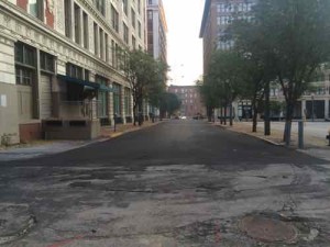
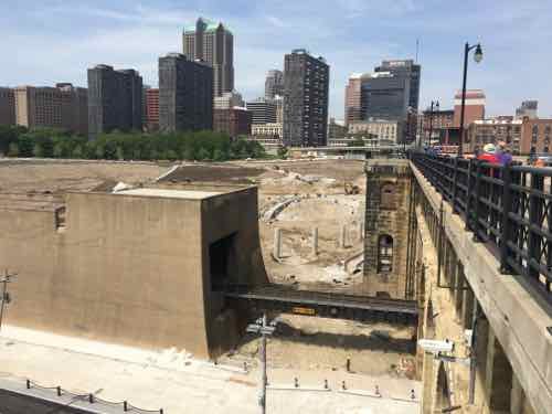
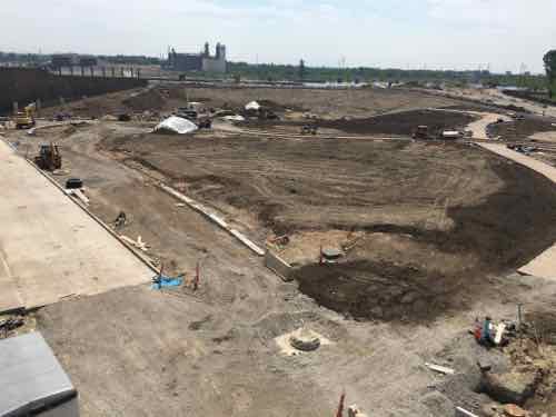
Over the last 8+ years I’ve written about the view from my balcony many times, including last Friday. Today’s post is about three locations I’ve covered separately: former CPI building, 17th St, and the former CPI parking lot:
Turns out the Kansas City developer isn’t keen on making 17th Street two-way as I suggested last year — he wants the city to abandon it for his private project. Board Bill 64 cites “Monogram Building LLC will use vacated area to improve safety and security.” What about the safety of everyone else who lives adjacent? Not having access to 17th Street will reduce our safety & security!
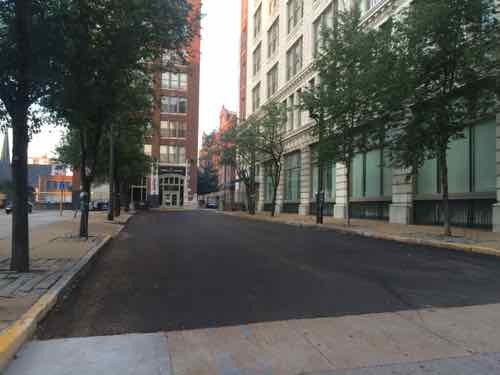
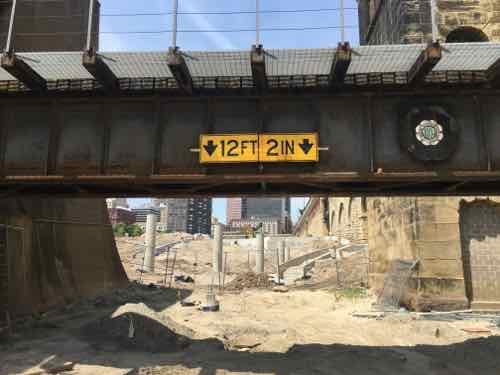
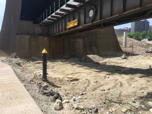
Looking South on 17th St from Washington Ave, this bit is one-way in the direction we are lookingThis view looks at the intersection of St. Charles (1-way WB) and 17th toward Locust (2-way)
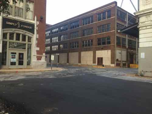
I get it — they want residents in the Monogram to be able to park in the new building and walk to their building safely, but their safety shouldn’t come at our expense. We all use 17th Street to access Washington Ave via foot & vehicle. We have a vacant commercial space that’s visible from Washington Ave. Also cut off from access to Washington Ave would be the former Dragon Trading building, Blu, Leather Trades. etc.
This block of public property measures 50′ x 150′, or 7,500 square feet. Ideally 17th Street would remain public. But if the city will cave and butcher our street grid again. we get something in return. In exchange, the developer should give 16.5′ of the East end of the lot so the 16th St right-of-way would be 50′, instead of 33.5′. This is 2,475 square feet. This would permit two-way traffic (18′), parking (14′) and generous sidewalks (18′) on both sides. They’d pay to reconstruct the West side of the widened 16th Street.
The significantly narrower 16th St is one-way northbound — the opposite of 17th
Additionally, St. Charles St (which is a glorified alley) should be widened from 38 feet to 50 feet so there’s room for 2-way traffic. trash & recycling dumpsters, moving vans, etc. A would require another 2,184 sq ft (12′ x 182′).
So we give up 7,500 sq ft in public property, but gain back 4,659 sq ft — a net loss of 2,841 sq ft. I’d prefer a zero loss of public right-of-way, but if they rebuilt the West side of 16th I could see it as a fair reallocation that could benefit everyone.
I ask that everyone reading this post to contact their Alderman before Friday and ask them to vote against the bill as written or amend it as I suggest above.
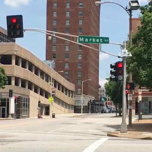
Recently my husband and I were walking/rolling back toward our loft from the Union Station MetroLink Station. For some reason we were on the East side of 18th — usually I’m on the West side. However, both sides are equally poorly designed and maintained.
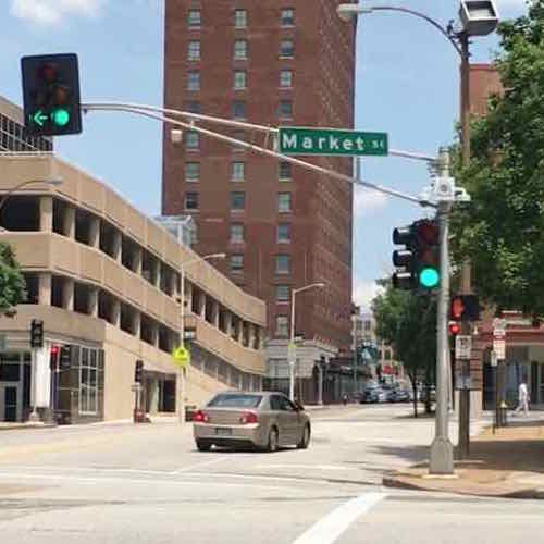
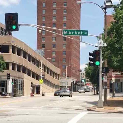
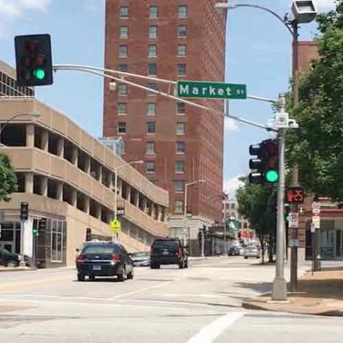
Anyway, we’re Northbound on the East side of 18th as we approach Market St and I notice something I’d never seen before: Northbound vehicles get a green light but pedestrians don’t get a walk signal while the left arrow is on. Since NB vehicles are turning left I get why pedestrians on the West side of 18th St aren’t given a walk signal. You’d never want to give pedestrians the ok to walk while drivers get a left arrow — like at Tucker & Olive and Tucker & Locust.
Why should pedestrians get a walk signal? Pedestrians have the right-of-way except in cases where vehicles are given a specific signal such as a left arrow. In this cases pedestrians must wait, but in the example the only turning cars would be NB ones turning right onto EB Market — they’d yield to pedestrians crossing the street — like most intersections. My guess is this is another instance where the city just didn’t think about pedestrian users.
Let’s take a look…
Vehicles have a red and pedestrians don’t walk, click image to view location in Google MapsNorthbound vehicles get a green light, those turning left onto Westbound Market get a left arrow. But pedestrians on the West side still get a don’t walkThe don’t walk remains as the left arrow goes yellow, then when Southbound traffic gets a green the walk signal to cross market comes onVery quickly the pedestrian signal begins to countdown to zero
Because still images can’t tell the full story I’ve put together a brief video:
Yes, another crossing at this same intersection is done correctly. If this were done right, pedestrians could cross Market St before Southbound vehicles get a green light and potentially make left turns onto Eastbound Market St — they don’ t get a left arrow so they must yield to Northbound vehicles and pedestrians crossing Market.
I see no reason why pedestrians don’t get a walk sign as soon as the Northbound traffic signal turns green.
Today post is another example of poor quality work. This isn’t about being a cash-strapped city — this is incompetence at all levels.
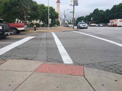
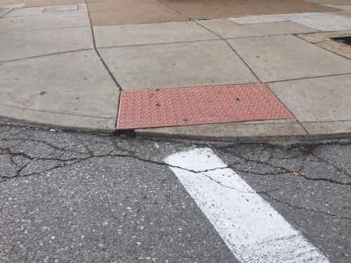
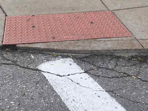
Looking West across 16th St at Market, note the location of the crosswalk relative to the detectable warning mat, click image for map to intersectionFrom the crosswalk looking toward the “ramp”Here’s a closer view of the ramp.
Looking at Google Street View I know this was done by the city sometime between September 2009 and August 2015. It was during this time the city took possession of the building from the federal government. I remember the old ramp, there are still some like it. It was done during a period when detectable warnings weren’t required, plus the location had no relationship with their crosswalk. But it was flush with the street.
The maximum vertical hight change allowable per ADA guidelines is 1/4″ — but this curb ramp is substantially higher than that. Sadly, it is very common to have greater than 1/4″ at ramps. Many are so bad I email the Streets Dept’s asphalt guy directly so they can do a non-compliant patch. Many things can be non-compliant, but still useful. This, and others, are hard to use and they damage the drive wheel on my chair. This would be very challenging for someone using a manual chair, and a trip hazard for a person walking with a cane or walker. In fact — this is a trip hazard for anyone walking here.
I have no idea if this was built by city employees or by a hired contractor. Either way, we’s never tolerate such shoddy work on our homes or cars — it shouldn’t be allowed in the public right-of-way.
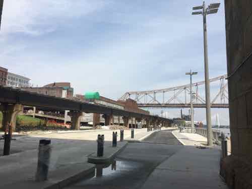
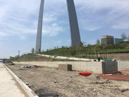
Great Rivers Greenway, the City of St. Louis, CityArchRiver Foundation and other partners invite residents from across the region to join them in celebrating the transformation of the St. Louis riverfront on Thursday, June 2. The organizations will be hosting a “Picnic on the Riverfront” event from 5:00 to 8:45 p.m., which will feature St. Louis’ largest-ever community picnic – complete with a 2,016-foot-long table with chairs – to commemorate the opening of the new riverfront beneath the Gateway Arch.
The official ribbon cutting on June 2 will begin at 5 p.m. on the overlook stage along Leonor K. Sullivan Boulevard, with remarks from dignitaries and partners. Afterward, attendees can explore the nearby Mississippi Greenway, enjoy local music and educational activities for kids and purchase dinner from food trucks and other vendors. People are also welcome to bring their own picnic meal. An interfaith blessing will kick off dinner at 6:15 p.m., followed by an aerial photo of all the picnickers. The event will end with a brief fireworks display at 8:30 p.m.
“This new front door for our region celebrates the energy, adventure and awe of the mighty Mississippi and our iconic Gateway Arch,” said Susan Trautman, Executive Director of Great Rivers Greenway, the regional parks and trails district and lead agency on the project. “We invite people to bring their friends, family and neighbors from all parts of the region to celebrate.”
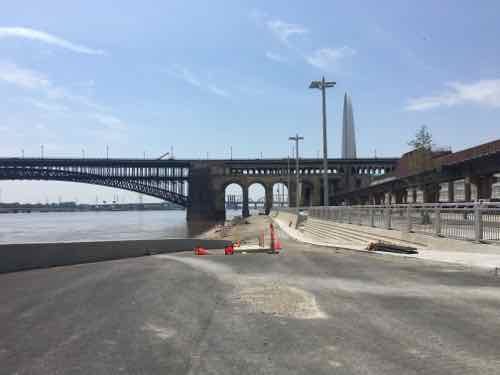
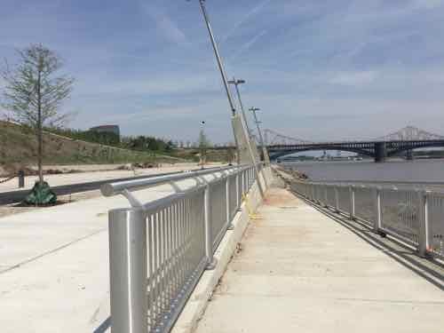
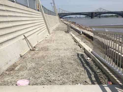
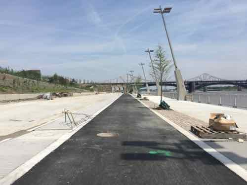
The renovation of the 1.5-mile stretch of riverfront includes the recently rebuilt Leonor K. Sullivan Boulevard and extension of the Mississippi Greenway from the Biddle Street Trailhead south to Chouteau Avenue, with protected walking and biking paths. The entire riverfront was elevated an average of almost two feet to limit flooding, returning more days of the year back to the community for walking, riding bikes, sightseeing and special events. While the historic elements were preserved, such as the cobblestones lining the levee; new amenities such as benches, bike racks, lights, power outlets and a street-level stage will make the space more inviting for events and programs. The lineup for this summer and fall includes bike rides, walk/run events, the St. Louis Brewers Guild Heritage Festival, a free concert series with The Sheldon, swap meets and more.
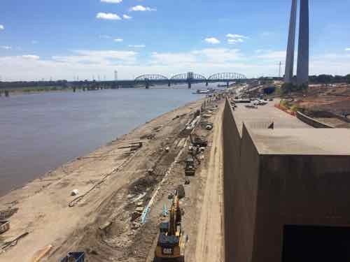
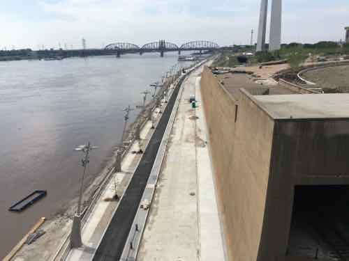
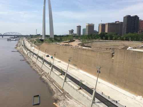
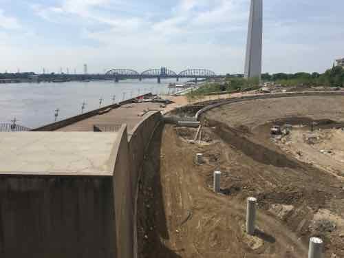
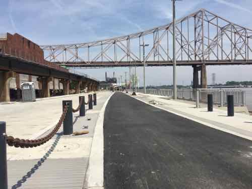
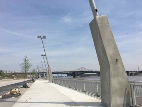
Earlier this month, on May 8th, my husband and I decided to check on the progress from the Eads Bridge. First though, a photo from September 2015:
Work continues on the North end of Lenore K. Sullivan — raising it was delayed by flooding. Click image to see September 2015 post with more imagesLooking more complete on May 8, 2016Looking West from further outLooking down riverMoving closer to downtownFurther WestDown on Lenore K Sullivan looking where Washington Ave used to beLenore K Sullivan Blvd is now higherLooking North from Eads Bridge, Laclede’s Landing area on the left beyond the elevated tracksFurther North, ML King Bridge in backgroundLooking back south toward the Eads BridgeNow at the center, some steps will be hidden by the new elevation of Lenore K Sullivan BlvdStill under constructions are four ramps from the top down to bottomThese ramps will be great for those of us in wheelchairs, pushing strollers, etcThere will also be ramps down to the cobblestonesIt appears a smooth concrete sidewalk will run along the base pf the wall next to the rough cobblestonesLooking South from the bike/job pathOne of the smartest ideas is concrete bases for light fixtures, these can go under flood waters without messing up wiring
So bring food, buy from food trucks, or just show up on June 2nd. I’m looking forward to exploring from end to end. Access is best from Chouteau or Laclede’s Landing Blvd (under the King Bridge).
AARP Livibility Index
The Livability Index scores neighborhoods and communities across the U.S. for the services and amenities that impact your life the most
Built St. Louis
historic architecture of St. Louis, Missouri – mourning the losses, celebrating the survivors.
Geo St. Louis
a guide to geospatial data about the City of St. Louis