The Metropolitan St. Louis Sewer District wants to spend $13.5 million of its own money to tear down vacant properties. Grassy lots would let stormwater slowly percolate into the ground instead of rushing into the combined sewer system that serves much of St. Louis.
While it could take several years to spend down the money, even the longest spending scenario would amount to a near doubling of St. Louis’ demolition budget. And areas where MSD sees the most benefit in terms of runoff and watersheds also are the areas – primarily in north St. Louis – where the city’s vacant properties are concentrated. (Post-Dispatch)
So I want to know if this is something you support or oppose?
This unscientific poll will remain open until 8pm.
An event ia taking place tomorrow afternoon in a once-thriving commercial district: The Wellston Loop.
“Wellston Loop Family Reunion & Exhibit” will take place on Saturday, November 21 from 1 to 3pm. A sidewalk exhibition of recent photographs and historic documents will highlight the community. The event will offer free food, drink, music and videos. The primary venue will be the former J.C. Penney Department Store (on the National Register of Historic Places) at 5930 Dr. Martin Luther King Drive, St. Louis, Missouri 63112.
We’re inviting members of the surrounding community (past or present) who would like to share stories, photographs or videos of the neighborhood (Wellston Loop, Hamilton Heights and Wells/Goodfellow) from any era to submit them for inclusion and display.
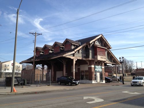
Another significant building in the former shopping district is the Wellston streetcar transfer station from 1909. It is also on the National Register of Historic Places. This building has recently been awarded funding for a complete historic restoration scheduled to begin December 2015. It is the only building of its kind (streetcar station building) left standing in St. Louis.
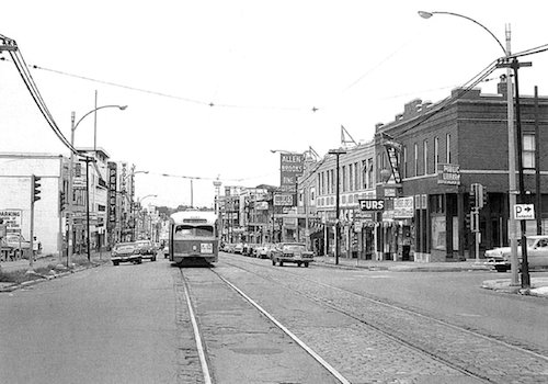
July 1963 image of The Wellston Loop from page 59 of the district nomination to the National Register, click to viewJust inside the city limits is the old Wellston Loop streetcar building, 2013 imageThe main location Saturday will be In front of the former JC Penny store at 5930 Dr. Martin Luther King Drive, click image for map. 2013 photo
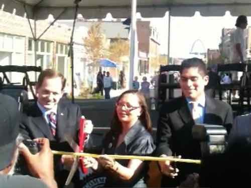
Five years ago today people were able to do what they hadn’t in 33+ year — drive on two blocks of North 14th Street.
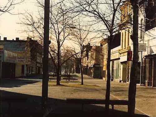
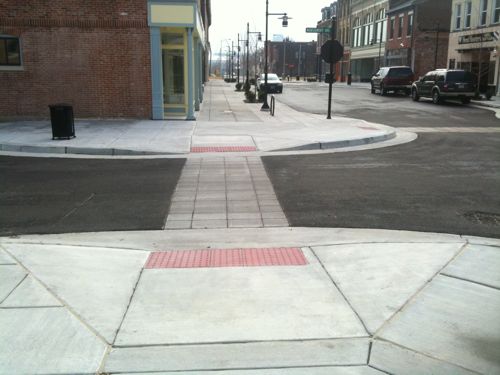
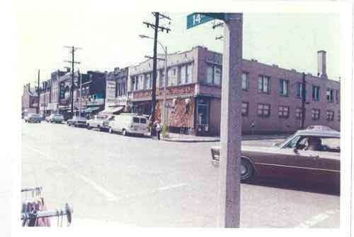
From 1977-2010 two blocks of N 14th was a “pedestrian mall”. By Spring 1991 it was already long-dead.After many years of trying to un-mall 14th, a ribbon cutting for the new street was held on July 29, 2010. But since new streetlights hadn’t arrived, vehicular traffic wasn’t allowed to drive down it.The new streetscape is friendly to both pedestrians & motorists, need not be mutually exclusiveThis photo is from a May 1972 thesis, taken before 14th was malled. Source: “A rehabilitation of a small commercial district: 14th Street in Murphy-Blair” by Norman Robert Spatz
My friend, filmmaker Phillip Johnson, has begun an interesting new project:
Hidden Jewels of North St. Louis is a photo book/video project telling the story of North St. Louis through the lens of homeowners living north of the “Delmar Divide” it is also a book that explores the reasons behind the Delmar Divide and projects a vision of a new North Side.
Here’s the video to kickoff the fundraising effort:
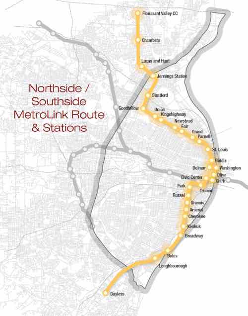
In a guest piece in the St. Louis American 20th Ward Ald. Cara Spencer makes a passionate plea for expanding MetroLink light rail:
The St. Louis region needs a high-quality light rail system to connect Florissant/Ferguson and our densely populated South Side to Downtown and the Central Corridor. Now is the time to push for economic investment to help stabilize some of the city and county’s most vulnerable communities. We should be demanding that our local leaders prioritize North Side/South Side MetroLink expansion as imperative to making St. Louis a progressive and economically just metropolitan area.
Public transportation speaks volumes about a society. Lack of transportation is an indicator of economic injustice and is the number one deterrent to employment and community involvement across the country. (St. Louis American)
Would light rail be more “just”? Those who don’t actually use public transit on a daily basis may think so, but the reality is the opposite.
Map currently being circulated, click image to view larger PDF in Scribd.
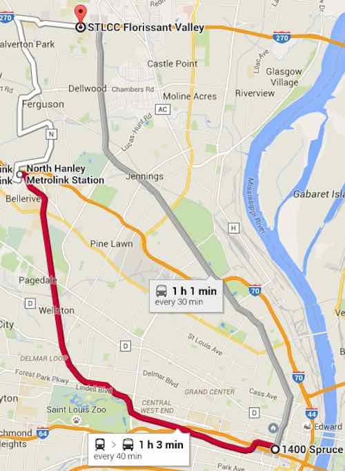
Currently to get from downtown (14th & Spruce) to Ferguson and the Florissant Valley Community College there are two options:
#74 (Florissant) MetroBus is the most direct option. This takes 1 hour and 1 minute with up to 68 potential stops along the way. That’s a long time, I’ve done it many times in the last year.
MetroLink (Red) to Hanley Station plus #36 (Spanish Lake) MetroBus. This option takes a total of 1 hour and 2 minutes. This route is 23 minutes on light rail with 10 stops, 10 minutes between modes, and 29 minutes on bus with up to 40 stops. I’vc also done this a few times.
The two primary choices for getting from downtown to Florissant Valley CC, click image to view in Google Maps. Note that times may vary, just depends on when you depart.
The proposed light rail line would certainly cut this down to 30-45 minutes. That’s a good thing, right? Not necessarily.
Very few ride the #74 MetroBus end to end. It’s a busy bus route but people get on/off where they need to. With 68 points of access it serves the corridor well. More frequent headways would be better though. The proposed light rail route would most certainly mean the #74 would end at a new Jennings Station MetroLink Station at Goodfellow & W. Florissant, rather than duplicate service from that point North. From Goodfellow & W. Florissant it currently takes 24 minutes to reach the community college at the end of the #74. The light rail map floating around would instead have just 4 stops including the start & end stops! How is that just?
The proposed light rail has zero stops in the area of W. Florissant that most uses transit.
Sure a light rail train may be faster and be more frequent, but that’s little consolation if you’re walking a mile further in the rain to get to a limited access point. For many current riders they’d now just end up having to walk their entire trip. Unless we ran a bus on the same route as the light rail train, which kinda defeats the point of spending tens/hundreds of millions on light rail.
Southside:
A similar situation occurs along the proposed Southside route. Currently a person downtown (14th & Spruce) seeking to get to Cherokee & Jefferson using public transit has two choices, both via MetroBus: #11 & #73
How long does it take to get from 14th & Spruce to Cherokee & Jefferson on these two MetroBus routes?
#73: 17 minutes, running every 30 minutes weekdays, with up to 18 points of access in that distance.
#11: 16 minutes, running every 20 minutes weekdays, with up to 19 access points.
Both are pretty quick. The Southside light rail being pushed follows the #11 route exactly between these points so let’s take a closer look. Google Maps includes the start & end stops in their 19 stop count. Here are the 17 access points in between:
14th St @ Papin SB
Chouteau Ave @ 14th Street WB
Chouteau Ave @ 18th Street WB
Chouteau Ave @ Mississippi WB
Chouteau Ave @ 22ND Street WB
Jefferson Ave @ Chouteau SB
Jefferson Ave @ Hickory SB
Jefferson Ave @ Park SB
Jefferson Ave @ 1605 S Jefferson SB
Jefferson Ave @ Layfayette SB
Jefferson Ave @ Russell SB
Jefferson Ave @ Shenandoah SB
Jefferson Ave @ Gravois SB
Jefferson Ave @ Pestalozzi SB
Jefferson Ave @ Arsenal SB
Jefferson Ave @ Wyoming SB
Jefferson Ave @ Utah SB
So how many stops would this “just” light rail make to serve the “densely populated South Side”? Five!
Chouteau & Truman Parkway
Jefferson & Park
Jefferson & Russell
Jefferson & Gravois
Jefferson & Arsenal
The density isn’t concentrated at just 5 points! Only a person who doesn’t understand transit can ague that spending millions while reducing 17 access points to 5 is “fair, just and equitable.” For example, everyone who works & shops at Jefferson Commons would now have to walk further. Sorry folks, remember this is “just” as your grocery trips are longer.
Back to Ald. Spencer’s op-ed:
On the one hand, it is exciting to see renewed interest in light rail in St. Louis County. Yet on the other hand, it is alarming that the expansions mentioned did not include a north/south route, but instead focused on the Clayton-Westport, Lambert-Florissant and Shrewsbury-Butler Hill lines. These three lines fail to provide service to the region’s most densely populated areas and many communities that have the highest need.
Northside/Southside light rail also fails to address actual needs — it would provide service for whites who are uncomfortable riding the bus with non-whites, see Race, Class, and the Stigma of Riding the Bus in America. You can have a free train running every 5 minutes 24/7 but if a person must walk a mile to reach a point of access they’re not going to use it. Stop pretending it benefits them.
AARP Livibility Index
The Livability Index scores neighborhoods and communities across the U.S. for the services and amenities that impact your life the most
Built St. Louis
historic architecture of St. Louis, Missouri – mourning the losses, celebrating the survivors.
Geo St. Louis
a guide to geospatial data about the City of St. Louis