Significantly Reducing Access Points To Public Transit Isn’t Fair, Just, or Equitable
In a guest piece in the St. Louis American 20th Ward Ald. Cara Spencer makes a passionate plea for expanding MetroLink light rail:
The St. Louis region needs a high-quality light rail system to connect Florissant/Ferguson and our densely populated South Side to Downtown and the Central Corridor. Now is the time to push for economic investment to help stabilize some of the city and county’s most vulnerable communities. We should be demanding that our local leaders prioritize North Side/South Side MetroLink expansion as imperative to making St. Louis a progressive and economically just metropolitan area.
Public transportation speaks volumes about a society. Lack of transportation is an indicator of economic injustice and is the number one deterrent to employment and community involvement across the country. (St. Louis American)
Would light rail be more “just”? Those who don’t actually use public transit on a daily basis may think so, but the reality is the opposite.
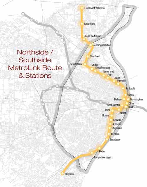
The above map is from the North South MetroLink Expansion Facebook page.
Northside:
Currently to get from downtown (14th & Spruce) to Ferguson and the Florissant Valley Community College there are two options:
- #74 (Florissant) MetroBus is the most direct option. This takes 1 hour and 1 minute with up to 68 potential stops along the way. That’s a long time, I’ve done it many times in the last year.
- MetroLink (Red) to Hanley Station plus #36 (Spanish Lake) MetroBus. This option takes a total of 1 hour and 2 minutes. This route is 23 minutes on light rail with 10 stops, 10 minutes between modes, and 29 minutes on bus with up to 40 stops. I’vc also done this a few times.
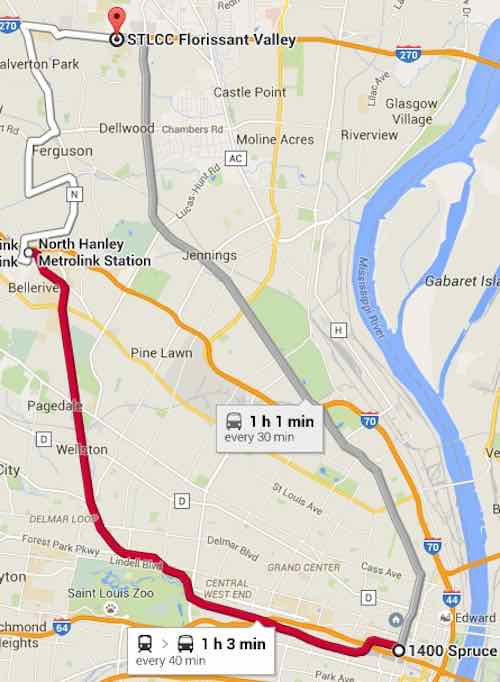
The proposed light rail line would certainly cut this down to 30-45 minutes. That’s a good thing, right? Not necessarily.
Very few ride the #74 MetroBus end to end. It’s a busy bus route but people get on/off where they need to. With 68 points of access it serves the corridor well. More frequent headways would be better though. The proposed light rail route would most certainly mean the #74 would end at a new Jennings Station MetroLink Station at Goodfellow & W. Florissant, rather than duplicate service from that point North. From Goodfellow & W. Florissant it currently takes 24 minutes to reach the community college at the end of the #74. The light rail map floating around would instead have just 4 stops including the start & end stops! How is that just?
Sure a light rail train may be faster and be more frequent, but that’s little consolation if you’re walking a mile further in the rain to get to a limited access point. For many current riders they’d now just end up having to walk their entire trip. Unless we ran a bus on the same route as the light rail train, which kinda defeats the point of spending tens/hundreds of millions on light rail.
Southside:
A similar situation occurs along the proposed Southside route. Currently a person downtown (14th & Spruce) seeking to get to Cherokee & Jefferson using public transit has two choices, both via MetroBus: #11 & #73
How long does it take to get from 14th & Spruce to Cherokee & Jefferson on these two MetroBus routes?
- #73: 17 minutes, running every 30 minutes weekdays, with up to 18 points of access in that distance.
- #11: 16 minutes, running every 20 minutes weekdays, with up to 19 access points.
Both are pretty quick. The Southside light rail being pushed follows the #11 route exactly between these points so let’s take a closer look. Google Maps includes the start & end stops in their 19 stop count. Here are the 17 access points in between:
- 14th St @ Papin SB
- Chouteau Ave @ 14th Street WB
- Chouteau Ave @ 18th Street WB
- Chouteau Ave @ Mississippi WB
- Chouteau Ave @ 22ND Street WB
- Jefferson Ave @ Chouteau SB
- Jefferson Ave @ Hickory SB
- Jefferson Ave @ Park SB
- Jefferson Ave @ 1605 S Jefferson SB
- Jefferson Ave @ Layfayette SB
- Jefferson Ave @ Russell SB
- Jefferson Ave @ Shenandoah SB
- Jefferson Ave @ Gravois SB
- Jefferson Ave @ Pestalozzi SB
- Jefferson Ave @ Arsenal SB
- Jefferson Ave @ Wyoming SB
- Jefferson Ave @ Utah SB
So how many stops would this “just” light rail make to serve the “densely populated South Side”? Five!
- Chouteau & Truman Parkway
- Jefferson & Park
- Jefferson & Russell
- Jefferson & Gravois
- Jefferson & Arsenal
The density isn’t concentrated at just 5 points! Only a person who doesn’t understand transit can ague that spending millions while reducing 17 access points to 5 is “fair, just and equitable.” For example, everyone who works & shops at Jefferson Commons would now have to walk further. Sorry folks, remember this is “just” as your grocery trips are longer.
Back to Ald. Spencer’s op-ed:
On the one hand, it is exciting to see renewed interest in light rail in St. Louis County. Yet on the other hand, it is alarming that the expansions mentioned did not include a north/south route, but instead focused on the Clayton-Westport, Lambert-Florissant and Shrewsbury-Butler Hill lines. These three lines fail to provide service to the region’s most densely populated areas and many communities that have the highest need.
Northside/Southside light rail also fails to address actual needs — it would provide service for whites who are uncomfortable riding the bus with non-whites, see Race, Class, and the Stigma of Riding the Bus in America. You can have a free train running every 5 minutes 24/7 but if a person must walk a mile to reach a point of access they’re not going to use it. Stop pretending it benefits them.
Related prior post: Northside-Southside Light Rail Wouldn’t Be Good For St. Louis Neighborhoods
— Steve Patterson
I mostly agree. One size does not fit all. While the current bus service primarily serves local riders, there are certainly other riders trying to go longer distances. What we really don’t know is the real demand, since the only two current options are to drive or to try and cobble together a trip on Metro. Providing longer “regional” or “express” services, by either bus or rail, would better serve transit riders of all races, as long as local service is maintained, as well. (And no, I don’t believe that this discussion should be one with racial overtones – transit usage reflects the racial makeup of the communities they serve – there are far more white transit riders in south city because there are far more white residents, there.)
Ald Spencer isn’t arguing for longer distances, she’s arguing to spend money serving neighborhoods in need.
Race is an issue — the MetroBus ridership is pretty much the same in South city as it is in North city.
It’s the city — everything is has racial overtones with select groups wanting an equal part of the pie. Alderman Spencer hints at it.
Looking at all of the proposed light rail stops along Jefferson (from Park to Cherokee), the distance between each stop is 0.4 to 0.5 miles… which means that all locations along Jefferson are less than 1/4 mile from a stop — or about a 5 minute walk. This does not seem unreasonable to me, especially as the distance between many bus routes in St. Louis is significantly larger than that.
By comparison, the typical distance between local subway stops in New York City is 0.4-0.5 miles… exactly the same as planned here in St. Louis for light rail. Is the NYC Subway system not fair, just or equitable?
You make it appear as if there are no alternatives to what is existing and what is proposed. The truth is successful transit systems integrate different modes like train or bus into a whole system that works. It is good that riders have options of speed vs stops. You mistakenly assume that leaves people out, but if the systems are designed to work together the trains supply one type of service, the buses another (true also of walking, subway, bicycle, streetcar and so on, all of which should be considered).
I have mentioned this before that the overall design of the system proves whether the system is successful or not, transit is for people to get around, not only take one route or another. Arguing over the number of stops of a specific line undercuts the functioning of the whole system. The real question here should be what does the ideal transit system in the city of st. louis and neighboring communities look like? No one has answered that.
The 2045 Connected plan by East West Gateway, remarkably cites the same transit projects that have been cited for decades as what they hope to see accomplished for transit by 2045.
It should be clear at this point, MoDot has no interest in transit And East West Gateway Council is equally poor in their approach
I was in St Charles County yesterday, the amount of property that has been taken over for development with many major roads created over the last 30 years is unbelievable. I don’t see St. Charles County as sustainable, even in the short term.
The problem is that The City of St. Louis does not offer an example of how transit can work for the benefit of the whole community. At this point city officials need to divest themselves of any planning services provided by MoDot or East West Gateway. They do not show the city, nor its citizens any consideration. (Maybe Scott Ogilvie has the guts to tackle this)
But yeah, your analysis neglects the potential of other design solutions. In fact I really don’t understand how, if there is not a comprehensive transit framework for successful movement systems, any judgment can be made on a rail line north, south or any direction.
Fragmented thinking is harming St. Louis socially and economically.
But if the conclusion is that MoDot and East West Gateway are largely worthless in this discussion then the question ultimately becomes what should replace them?
That’s my point. My assumptions are based on past experience with transit in St. Louis. There hasn’t been any discussion about how the proposed North-South light rail would impact existing bus lines and their bus stops. This needs to be part of the conversation and not get lost in the excitement of building something new.
I hoped this post would spur discussion about the type of service we want. We have elected officials pushing “MetroLink” but in-street light rail — which we’ve never done before. I’m sounding the alarm that, unless we make it a priority, many bus stops might go away both north & south. Would the bus lines continue in parallel with the light rail?
You are both correct – cities with good transit have integrated SYSTEMS – it’s not all of any one thing, rail or bus, diesel or electric. Until we move beyond investing in one random line at a time, we’ll be condemned to repeat the same stuff we’ve been doing, poorly, for decades. Unfortunately, the way this post was presented just reinforced the one-line-at-a-time mentality (by focusing on this one corridor). You may have wanted to “spur discussion”, but the only logical discussion would be about the spacing of stops along this corridor, not a discussion of how to better serve the entire region, rich and poor, black and white.
We’ve got to get into a lot of nitty gritty stuff in order to figure out what kind of system we want, access points are a huge part of that picture.
This post is focused on why one light rail line is not a good solution for riders in the city, primarily because (you assume) that a local bus route (and most of its stops) will be replaced by light rail (if it ever happens). To create a viable transit system that works well for the entire region requires looking beyond the city’s arbitrary limits. It also requires embracing the idea that suburb-to-suburb trips are just as important as trips into and out of the CBD.
Yes, we ultimately need “to get into a lot of nitty gritty stuff”, but focusing on where stops are, on any one line, now, ignores the much bigger need to create a route structure, a web of interconnecting lines, that actually connects most, if not all, employment centers in the region. Metro continues to run a legacy route structure that assumes most riders are “good” with going through downtown on most of their trips. While this may have made eminent sense a century ago, and even 65 years ago, it makes far less sense today.
If we want “to figure out what kind of system we want”, we need to look at the big, wholistic picture, first, then eventually work our way down to the nitty gritty of where individual stops are located. It makes no sense to discuss stops if we don’t know (or can’t agree on) what technology will be used or which alignment every route or corridor will be taking. You’re a trained planner, you know that there are processes that need to be followed to get to defensible conclusions. As long as we (the region, Metro and transit users across the system) continue to focus on one line at a time, we will continue to have a patchwork “system”, one that serves a decreasing number of riders adequately, and continues to become increasingly irrelevent to more and more regional residents (and potential users and supporters).
We need to look at where people live, where people work, where people go to school, where people shop and where people play. We need to connect the dots, we need to disrupt the current thinking. We can’t assume that just because a route has worked for 50 or 100 years that it shouldn’t change or be eliminated. Omaha did it recently, and other cities, including LA, Houston and Dallas are doing the same thing. St. Louis desperately needs to do this, as well, and the sooner the better.
http://www.citylab.com/cityfixer/2015/05/omaha-just-designed-a-way-better-transit-system-for-zero-cost/393620/
http://www.houstonpublicmedia.org/news/metro-board-approves-big-changes-to/
https://letsgola.wordpress.com/2015/02/01/rethinking-metrolink-part-1/
http://frontburner.dmagazine.com/2014/11/11/dallas-really-can-have-a-great-public-transportation-system/
I guess you overlooked the discussion about Ferguson? In St. Louis I’ve learned that once ideas have enough momeumum they must be derailed (get it?) in order to get the focus on the big picture.
To derail a new Metrolink line won’t take much – it’s called funding. With the feds less able to pay for a significant portion of the cost, here and elsewhere, the need to come up with a significant portion of the project’s costs with just local funding will be extremely difficult to cobble together. That’s why I’m not too worrired about parsing where stops should or should not be on a line that most likely won’t be constructed in my lifetime!