Northside-Southside Light Rail Wouldn’t Be Good For St. Louis Neighborhoods
Lately I’ve been hearing people wanting the build the long-planned Northside-Southside MetroLink lines. While I’m a huge advocate of public transit, rail transit in particular, this would ultimately be a costly disaster for St. Louis’ neighborhoods.
For the Northside corridor, the preferred transit alternative was a MetroLink line running from downtown St. Louis north by using rights-of-way along several streets including 14th Street, Natural Bridge Avenue, and West Florissant Avenue into North St. Louis County. Two potential preferred alternatives were selected for the Southside corridor. One was a MetroLink extension from downtown St. Louis running south using rights-of-way within 14th Street, Chouteau Avenue, the Union Pacific Railroad track and along I-55. The other possible design was a Bus Rapid Transit system from downtown south via Market Street, Grand Boulevard, to rights-of-way alongside the Union Pacific Railroad track and Loughborough Avenue, then via I-55 to South St. Louis County. (Northside-Southside Overview)
Here’s what I think these people don’t understand:
- This would be a completely separate system from our existing light rail — Northside-Southside would use different vehicles & track. An existing line coming from the airport, for example, wouldn’t be able to run into south city. Passengers would need to exit the older high-floor light rail vehicles at the Civic Center MetroLink station and walk to 14th Street to board the new line. Fares could be integrated, but physically separate otherwise.
- The vehicle type used would be the same as the proposed St. Louis Streetcar. These are modern vehicles and are an excellent choice. When used as “light rail” they operate in dedicated right-of-way (ROW) with far fewer stops so as to achieve desired speeds end to end. As streetcars they stop much more frequently, putting more people closer to a stop. The tracks can be crossed easily by pedestrians & motorists. Connectivity, not speed, is the priority.
- The goal for Northside-Southside was to end at large park-n-ride lots and get suburbanites through “scary” city neighborhoods and into downtown as quickly as possible. Stops would be over a mile apart.
- To achieve necessary speeds the number of conflict points between rail & autos/pedestrians would need to be greatly reduced. This is accomplished by building a median down the center of the road (Natural Bridge, Jefferson) with very few points to cross. That left turn you used to make would become impossible, as would walking across the street at all but a few points.
- Property along the routes would need to be taken, some buildings razed. This is because creating a dedicated ROW takes lots of room — more than even our generous ROWs have to offer.This light rail ROW would act similar to a highway — dividing the neighborhoods on either side in an effort to rush people through as quickly as possible.
These are not positives for the neighborhoods, unless you live near one of the few stops it won’t be useful to residents.
We don’t have any examples of light rail in the center of a road, so we need to look elsewhere. In 2012 I visited Dallas and rode their Blue Line south in the center of Lancaster Rd.
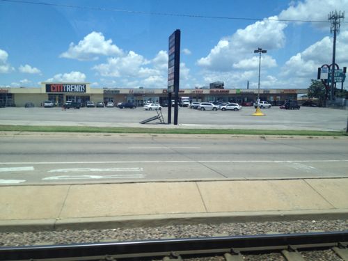
All of my photos are from inside the light rail car or at the stations. To understand you you need to view from outside. Short of a personal visit, you can look at Google’s Street View.
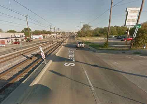
Light rail doesn’t appear to have spurred any development in the 18 years it has been open. The rail vehicles, however, do move at a high speed between stations. Success depends on your goals.
What the St. Louis neighborhoods North & South need is an investment in excellent localized rail transit — streetcars. Again, the vehicles are virtually identical — it is the design of the track and number of stops that make the difference. To me, the South/Jefferson County person driving downtown is likely to just stay on I-55 to reach their destination — we shouldn’t design this to persuade them to exit the highway and park in a big parking lot.
We should design & invest in infrastructure that brings the neighborhoods together, that helps local merchants. Light rail is the wrong choice, streetcars is the best rail choice. If you’re opposed to MoDOT’s plans for Gravois you should be opposed to creating a light rail ROW in the middle of our major aerials.
— Steve Patterson
I don’t get it. If light rail goes down the middle of the street, why does it require taking private property? And since the project is years away and still in the planning stages, who’s to say how many stops there’ll be? The Loop Trolley isn’t taking any private property, goes down the middle of the street, and local residents and merchants seem to be pretty happy about the project.
Traditional Light Rail uses trains which generally require platforms and infrastructure which, combined with the accompanying expected commute times, means fewer stops, an expectation of reduced at grade crossings and increased right-of-way needs.
Creating a decpducated ROW requires space for two tracks, curbs, fences, etc. Add to that room for cars. The property that would need to go is to make room at intersections, especially where the train would turn.
When did this become a non-Metrolink plan? Or the dispruptive scenario you describe? Scott Ogilvie is one of the efforts’ biggest supporters. Are you suggesting that he and others behind this program are misguided? Or are they supporting something else? There seems to be a pretty big movement behind this idea. Are all of those people following bad planning? This post seems out of phase with the stance of progressive leadership in St. Louis.
This has always been a separate system — the high-floor vehicles used on our current MetroLink couldn’t be used in the middle of the street — it could take too many ramps to meet the ADA.
Those of us who attended the public meetings in 07/08 know the drawbacks, I wrote about it at the time.
Why do you need on-ramps? Couldn’t Metrolink tracks dip below grade at stops to be flush with the level of the street? That would make them ADA accessible.
Probably issues with drainage, safety and trash. Denver uses Siemens light rail vehicles similar to the ones St. Louis currently uses, and uses what they call high blocks to provide wheelchair access to the front door: http://wheelchairtravel.org/wp-content/uploads/2015/02/den-light-rail-300×200.jpg
I am a former St. Louis resident, am now in a wheelchair and visit St. Louis often.
My most recent trip to STL was three weeks ago, and I do see immense value in rail for citizens in wheelchairs. I believe, though, that the funding should be directed to other areas, like sidewalks and streets.
Convenience is one thing. Greater rail access throughout the city and surrounding areas is a desirable convenience. But the deteriorating sidewalks that are not ADA compliant is a greater personal concern. Having to roll my wheelchair in the street around an I-64 exit ramp is unbelievable. I have written more about this here, on my website: http://wheelchairtravel.org/st-louis-mo/#sidewalks
I think the focus should first be placed on making the city safely accessible to pedestrians. Public transit can be improved later.
Thanks for your comment and website, as you may know I also use a wheelchair.
Light rail tends to focus on the stations only whereas BRT & streetcars tend to update the whole streetscape along the entire corridor.
To leverage the investment made in any mode of transit the sidewalks and such should be upgraded to make getting to/from stops more pleasant for everyone.
Where have streetcars or BRT “update[d] the whole streetscape along the entire corridor?! With one exception (the 16th Street Transit Mall, in Denver), every project I’m familiar with has focused primarily on stops and their amenities, and have done little to improve the sidewalks parallel to the routes. If Metro decides to do BRT or streetcars, instead of light rail, for a northside-southside line, I doubt that they’ll have the budget to completely rebuild whatever streets (and the adjacent sidewalks and curb cuts) they choose to operate on, any more than they’ve reconstructed streets around their current light rail or bus lines. (If anything, going with street-running light rail might “force” more major street reconstruction, but I don’t see that as a valid reason for pushing for light rail.) But the real issue is that sidewalks are not Metro’s responsibility, they’re the city’s. Until the city decides to make pedestrian access, including compliance with the ADA, a priority, and commits to funding the construction of several thousand curb cuts AND requiring property owners to comply with current ordinances to maintain existing sidewalks in a safe, level and passable condition, pedestrian access throughout the city will continue to be hampered by far too many “missing links”!
No argument from me. North/South streetcar lines (possibly terminating at current LRT stations) would be great!
You are 99% right! Both “light rail” and the “preferred alternative” (as currently adopted) would be focused on moving suburban commuters; any “benefits” for local residents would be limited to the immediate areas around the few stations. I’ll even agree with you that streetcars would be “the best rail choice” for this corridor. Where I disagree is in the need for (or the wisdom in) investing in any more rail transit in St. Louis. IF (and that’s a big if) we can find ANY more money for transit, to BOTH build AND operate more service, our first priority should be increasing frequency and expanding service to cover more areas in the region, NOT investing in more-expensive “solutions” that will only replace existing buses with streetcars, that will (only) run on the same schedules and (mostly) just serve existing riders.
One of the biggest complaints about transit in St. Louis is that it takes multiple times longer to get anywhere (on transit) than it does/would take driving. Part of that is the number of stops, but a bigger part are the route system and the schedules – if you can’t find a direct route, you have to transfer, and if you have to transfer, you have to wait, sometimes for 20 or 30 minutes! The best solution would not be concentrating service along rail lines, the best solution would be diffusing service, with smaller buses operating more frequently on more parallell (not radial) routes. The best solution would create a system where schedules are not really needed – a bus would arrive every 5 minutes and transfers would be free and easy. With the Northside-Southside corridor, bus rapid transit (BRT), properly implemented, not light rail, not streetcars, would be the best solution. AND, with BRT, there would then be enough money “left over” that we could do BRT on ANOTHER corridor, like Grand or Kingshighway, improving service for more riders!
As you noted, correctly, in Dallas, “Light rail doesn’t appear to have spurred any development in the 18 years it has been open.” The same observation would also apply, here, as well. Light rail’s biggest benefit is in making commuting easier, by moving large numbers of commuters over longer distances. It allows developers in dense areas, near stations, to shift the cost of providing parking onto suburban park-and-ride lots. Light rail is both a choice and a tool (as are streetcars).
Where you and I disagree is in the real “answer” – yours always seems to be “streetcar”, while mine is usually “transit”, in all forms, but primarily buses, properly and uniformly implemented. The biggest problem I have with the current efforts to implement / “bring back” streetcars in St. Louis is that there appears to be absolutely no effort to integrate them into the existing bus network, nor to justify the investments they require other than a Pavlovian response to “it’s rail”! We have “rail” with Metrolink, yet we are far from using it to its fullest capacity. The most (and the least) we use are two-car consists (trains). Most other transit systems have the ability to (and do use) multiple-car (3, 4, more) consists, to move large numbers of riders quickly, for commuting and for major (primarily sporting) events. Streetcars would just be more of the same, a fragmented attempt to just do something different. Transit should be about meeting the needs of all riders, not just those of developers, politicians, transit geeks and rail fans . . . .
While I’ve found myself in serious disagreement with you in the past Jim, this probably best represents my view as well. I know I’m going to get shouted down and called an urbanism traitor for not walking in lockstep with the usual consortium of urbanists in STL on this issue, but BRT is a much better investment than more fixed rail at this juncture. Our city buses can’t operate effectively because the routes are simply absurd. Why does (or did, until very recently) the 30 Soulard bus run past my front door on the city/county line, as far west as can be traveled in the ‘Lou? A proper BRT network would allow the city buses to again become what they are really designed to be, and that is neighborhood loop transit. A five or six stop line running right through the central metro corridor on I-64 from the Valley to downtown, and then on to St. Clair County and back would bring more ROI than a fixed-rail system. A BRT route can change as needed, and fixed rail obviously cannot. We do not yet have the population density where urbanists desire to justify this investment now. A BRT network seems to make much more sense for the STL metropolitan area as the next step in a growing multi-modal transit network.
BRT is an affordable way to attract new “choice riders” to transit — those who’d never consider standard bus service. BRT & Streetcars both would mean fewer stops than the bus routes they’d replace — a negative to those who’d now have to walk further.
While modern streetcars require more upfront capital than BRT they spur more devilment — which should be a goal because otherwise BRT is just a fancy bus.
I don’t think they’d be replacing any existing bus routes, but instead only allowing them to better serve their intended ridership on a short, neighborhood loop. A BRT is an intermediate connective line and not a neighborhood-scale line that stops every several blocks. No built transit line can be relied on to spur development, because the location has be viable first. A bullet train speeding through Death Valley won’t spur much development, as the location is not desirable for such, as an example. Obviously, I’m not suggesting that our city is not viable for development but rather that reliance on transit is less of a certainty than I think we’re willing to admit. Build it, and they will not come.
Metro can’t afford to operate bus & BRT on the same route.
I’m not sure we’re envisioning the same thing, Steve. I’m suggesting that the BRT would ONLY run on corridors that are conducive to higher speed for express service. I’m not suggesting a shadow bus route that only “skip stops” at strategic points, like a P-I elevator. The routes interact, but do not overlay.
Hmm, the #11 MetroBus runs on 14th. Chouteau, Jefferson, & Chippewa — most of the route planned for southside rail. The #10 runs on Gravois. The #4 & #74 on Natural Bridge & North Florissant, respectively. Both on the route for northside rail.
What are these magical corridors for higher speed BRT that don’t have existing MetroBus routes on them?
There’s nothing magical about higher speed corridors like Gravois,/N. Florissant/Tucker, for instance. I can agree that some corridors are already well-served by existing bus routes, but some of these could share a larger overlap like Kingshighway and Grand, for instance. I see no problem using the expressways for obvious advantage, but the purpose of BRT is obviously for express service only. The Max in KC is poor example of such a bus line, but the Rapid in Phoenix is much better.
Metro “can’t afford” to operate a bus and a streetcar on the same route, either! And if you say a streetcar, operating locally, is better than a bus, I’ll counter with, for most riders, they could care less whether the vehicle operates on rails and steel wheels or on concrete and rubber tires. What they (we) really want is frequent, clean, safe service; the type of vehicle is highly secondary!
What do developers want to build higher density buildings with less parking? What do merchants want to increase foot traffic? Any investment (BRT, Streetcar, LRT) must be about more than just moving people from A to B.
Government should not be playing favorites in the development game! If developers want to provide less parking, let them either take the risk that the space won’t sell or lease or let them pay part of the cost of developing the suburban park-and-rides and the connecting, high-speed infrastructure. And most merchants could care less about foot traffic. Most merchants just want more CUSTOMERS and most merchants will agree that most customers (want to) drive to their stores! And no, the primary reason for investing in public transit IS to MOVE people from point A to point B, and to hopefully encourage those potential choice riders to forego using their single-occupant vehicles. Good transit can be an amenity for any development, but good transit, alone, will do little to spur new development – see anything along our existing Metrolink line, north of the Delmar Station!
If the city wants development & density it needs to switch from parking minimums to parking maximums. Developers will want good transit to be more comfortable with the change.
And yes, we’ve already seen new development along the Loop Trolly route: http://www.urbanreviewstl.com/2014/12/followup-gotham-apartments-completed/
Why does the potential N/S Metrolink have to be traditional? Why can’t you have light rail with more frequent stops? Can’t Metrolink behave as a streetcar with slower speeds when running in the street ROW. I don’t see why it has to be so black and white.
And stops don’t have to be every mile. They could be every half mile. Have “express” service to appease the suburbanites wanting to get from the county to downtown more quickly.
Speed is the difference between light rail and streetcars. To get federal funding for light rail you must show it’ll be as fast as driving, reduce traffic congestion.
No, the differences occur on multiple levels: http://www.rtd-fastracks.com/media/uploads/gl/lrt_streetcar_analysis_formatted.pdf . . Maximum operating speed is almost always determined by the operating environment – urban and tight or suburban and wide open – NOT by the technology chosen!
I imagined N/S operating as a streetcar within city boundaries, with LRT stops in the burbs. But maybe someone more knowledgeable has a logistical problem with that idea.
I doubt express service is feasible, as it would require 3 or 4 tracks instead of 2
I don’t think you need three or four lanes. You just skip certain stops. Have you ever been on the A train in New York? It does the same thing.
In regards to getting federal funding, add additional stops after its built and the federal funds have been used.
It all depends on how long the route is and how far apart the trains are when they start. Once the express train catches up with the local train, and can’t pass it, it becomes just as slow as the local train. Dwell time (the time spent stopping at a station, opening the doors, waiting as long as needed for passengers to get ooff and on, then closing the doors and leaving) generally takes a minimum of 70 seconds. Adding five stops adds a minimum of 6 minutes to the schedule.
The A train is quadruple-tracked.
It should be a streetcar, not the planned high-speed light rail that was planned.
Grade-separated lightrail on the Southside (ahem, DeSoto), center street-running lightrail along Florissant/Natural Bridge. Done and done.
There shouldn’t be any “timing” issues with your proposal.
I too have ridden that Dallas DART system. Comparing the sprawled out suburbs of Dallas to some of St. Louis best and most dense neighborhoods is apples and oranges. It also seems to me, those vehicles in Dallas transition from light rail to street cars in the downtown area.
A North-South line would be an improvement to the people that already live in St. Louis city. Building more sprawled light-rail out to the suburbs isn’t going to convince anyone to invest in city neighborhoods. And if the concern is about the arterial, I again take umbrage with the idea that the city needs these high-speed 4+ lane roads to make it easier for the drivers leaving the city. Many studies show a slow-speed dense grid has a higher vehicle capacity and because of the slower speed is safer for pedestrians and bicyclists.
Again, we should improve the city for the people who live here. Ironically that’s how to attract people/investments.
The comparison is fair in terns of how the light rail planned for N/S would be physically built in the street ROW.
Are you opposed to scaling down Jefferson/Natural Bridge roads to make room for the
rail line? Or is there something I’m missing? I should point out, that my assumption of along the street light rail on Jefferson through South City and Natural Bridge through North City would mean those roads lose lanes as a priority would have to be given to pedestrians/the train itself over automobiles.
One can oppose the MODOT Gravois plan, mostly since we shouldn’t have the state designing city streets (faster for cars=less safe for everyone else) and still be in favor of non-automobile transit projects that have a higher ROI to the city than building streets so county residents can get on the interstates faster.
I’m a huge fan of road diets & rail transit, but having attended planning meetings on N/S in 07/08 I know what was presented was fast lanes for cars and a fast median for light rail. A lose-lose.
Given that it’s all hypothetical and potentially several years away, the criticism seems overly harsh to me. The North-South line through the city is the best option to utilize neighborhoods that were once friendly to not just automobile drivers (unlike the DART examples shown) and returning them to that state compared to a Westport line along I170/Page or a suburban commuter rail line long I44. The prosed map I’ve seen would really be all that high speed through the city as the distances between the stops isn’t that far.
Again, I love the idea of rail infrastructure through our north & south city neighborhoods! I felt it was necessary to counter misperceptions like the faux images at https://www.facebook.com/NorthSouthMetroLink
Please elaborate. The images shown are either from other cities or are intended to present a positive image of rail transit in the city. The only thing I see as “faux” is that some show light rail operating in mixed traffic, which given the right situation / environment is NOT a bad thing.
Mixed traffic light rail doesn’t exist. Whomever created those images is selling a bill of goods that’s not what was planned for in 2008.
Light rail does require a dedicated right of way, no different than a dedicated bus lane, but only minimal separation IF it operates at the posted speed limit – from Denver, Baltimore & San Diego: http://wikitravel.org/upload/en/thumb/8/89/Denver-lightrail.jpg/250px-Denver-lightrail.jpg . . and http://upload.wikimedia.org/wikipedia/commons/2/2c/Baltimore_Light_Rail_train_leaving_Baltimore_Street_station.jpg . . and http://i.ytimg.com/vi/I-OYnsDp1Qg/maxresdefault.jpg
That was my impression about N/S running along city streets as depicted in those photos; it would have dedicated track but wouldn’t be fenced off,etc. and would run at the speed limit… as someone else said, functioning more as a street car on surface streets with higher speeds along the 55 corridor. I would have concerns about being fenced off and going more than the speed limit, etc. but this is the first I’ve heard of that being what would happen. I’d like to see any source material stating this as what is intended.
Yet the 2008 study was all about creating a dedicated ROW.
Those pictures ARE of dedicated ROW. Maybe it’s not obvious? Cars are not permitted to drive along the tracks. All three photos, Denver, Baltimore, San Diego.
Newstead station from the 2008 study.
thanks! I don’t remember seeing that but that was my general expectation.
Mixed traffic light rail with high-floor trains does indeed exist, no dedicated lane required. See Buffalo which is busy reintroducing cars to its downtown transit mall.
According to Wikipedia 80% of their line is underground. “The remaining 20% of the alignment (1.2 miles (1.9 km)) is on the surface in a dedicated outdoors transit mall separated from automobile traffic on Main Street in downtown Buffalo.”
http://en.m.wikipedia.org/wiki/Buffalo_Metro_Rail
::eye roll:: Really?! I give you photographic proof, and you refute it by referring to Wikipedia? I mean, come on!
Cars (Finally) Return to 600 Block of Main
Sorry, the photo attachment didn’t show up on the admin email.
Ok, so a 1.2 mile section of a 1985 line is now introducing a lane of traffic in each direction. With closely spaced stations this section has likely never achieved light rail speeds like the underground portion with stations further apart. It’s a good step for Buffalo, but hardly a model for Jefferson or Natural Bridge — major arterials.
So let’s add the term “interurban” to the discussion: http://en.wikipedia.org/wiki/Interurban . . “light rail speeds”, while potentially higher than “streetcars”, is a misleading term – the operating speed of ANY mode is defined by its operating environment, and any mode will be operating well below its potential peak speeds whenever it’s approaching or departing any station or stop. The big advantage of light rail over streetcars is the POTENTIAL to move more passengers, with one operator, at higher speeds (the same applies to a Boeing 747), than a streetcar; the disadvantage is that it’s going to cost more, IF it’s not used to capacity. Selecting the “right” mode, including bus versus rail, needs to balance projected (and, ultimately, actual) demand and frequency, along with desired station spacing.
Furthermore, there’s no good way to create a north or south line off the existing LRT downtown. Unless the vehicles can easily go from the existing line to the new there’s no advantage to using the same high- floor — only disadvantages.
I’ll mostly agree with you. Of course, the trouble is what to do in the very looong term when northside is connected to Westport and southside is connected to MetroSouth.
This is why expansion into north & south county should come off of existing MetroLink lines, like Shrewsbury. Let the north & south city lines be local service. Going through Clsyton rather than Downtown is also more central — not everything needs to run through downtown.
While I understand your points, I think your logic is flawed. People want speed and people want mobility. If streetcars are just buses that are trains, with no dedicated ROW, there’s zero mobility improvement for people, especially those that are transit dependent. In that case streetcars only function would be economic development and attracting a richer clientele who might be squeamish about riding the bus.
Transportation infrastructure should be much more than that.It has to actually offer real improvements for the people who already use it, mixed traffic streetcars would be a complete waste of money. Cities have built BRT systems to give buses dedicates ROW why would it be so damaging to give streetcars the same treatment? Also, you assert there’s no LRT in the middle of streets yet Boston’s greenline runs in the middle of Commonwealth avenue.
I might add that dedicated ROW streetcars don’t have to be light rail and can have frequent stops, as they have in many cities including San Francisco, Toronto, New Orleans, and most European systems. Seattle is even studying putting its streetcar in dedicate lanes: http://www.thetransportpolitic.com/2015/03/23/does-seattle-offer-the-path-forward-for-the-national-streetcar-movement/
Broadly, you need to think about transportation as a mobility system, a people-mover, and not just an economic development tool.
No LRT in the street in St. Louis — except a little bit of Forest Park Parkway.
Agreed — streetcars or BRT would need a traffic-free lane and signal prioritization to improve the speed over standard buses. The idea of getting LRT fast enough to compete with motorists on I-55, for example, is where LRT needs to fly through city neighborhoods.
We have no real congestion in the St. Louis region, so LRT in street ROW is very hard to justify the needed capital.
Using that logic (“We have no real congestion in the St. Louis region”), any investment, in anything other than buses, to serve local communities and transit-dependent riders, would seem to be a waste, as in “very hard to justify the needed capital”.
Development, development, development!
If rail transit created more demand for “Development, development, development!” St. Charles County would be infested with streetcar and light rail projects, with New Town as the hub!
Not a perfect solution, but if the City/Bi-State could swing a deal for the DeSoto ROW that arcs through the southside, there’s ample opportunity for connecting neighborhoods, improving the perception/use of transit across all income-levels, and encouraging transit oriented development, all with extremely limited demolition and/or eminent domain.
If the will (and $$) was there, maybe you remove the bump and bury the line at Morganford/TGP, TG Ave and pick the ROW back up at Vandeventer. Basically, you’re cutting otu one neighborhood (The Hill) to create a little straighter/quicker route.
Here’s an image with a potential station list:
Also, here’s a link to my “Cadillac” image for a southside system. The yellow line is the previously mentioned DeSoto route, the orange line touching down at Loughborough is the tail end of the “preferred alternative” Downtown->Chouteau->Jefferson->I-55 route and the dotted lines along Gravois, Grand and Broadway represent either a streetcar system or BRT/Express, your call. Existing bus routes are also included.
https://twitter.com/YASTLBlog/status/469459622110052352
I don’t see a mention of the route that I believe was chosen in 2007/08 as the locally preferred alternative. That went down Jefferson in South City and had multiple stops (Park, Russell, Gravois, Arsenal, Cherokee, Keokuk) — much more frequently than over a mile. A bit longer distances in North City but still more frequently than a mile. In comparison, the pseudo-BRT plan Metro recently pitched for North City/County did have longer spacing between stations than the EWG LRT plan.
Ah, I see a brief mention of Jefferson (in a parenthetical notation) but again the impression given is that the plan would get countians through scary city neighborhoods as fast as possible with city stops over a mile…. that may have been an early intention but isn’t the case with the refined alternative.
Jeez. Can we meet to discuss?? You’ve got some of this way wrong.
Like what?
While I share some concerns on the potential design of N/S, your leaving the impression that stations would be more than a mile apart was deeply misleading.
The Northside stations in 2008 were about a mile apart — not misleading at all.
Umm, not sure how you figure stations every mile. Are you including the long stretches out to Butler Hill and Florissant? Excluding downtown, Northside within the city has a station every 0.75 miles; Southside every 0.75 miles including the nearly 2-mile run to the Bayless station.
Ok, but even 3/4 of a mile is a long walk compared to roughly 1/10th of a mile between bus stops. Stops more than 1/4 mile part will result in circular development, at best, rather than linear development.
Stops every 1/2 mile or so is golden in my book…. a nice balance allowing for quicker commutes and redevelopment opportunity, .
South city has stops ranging from 2,000 – 3,300 feet along Jefferson with the longest one b/w Cherokee and Keokuk. The stations along Natural Bridge range from 2,000 – 4400 feet apart, with the longest being between Goodfellow and Union. Not nearly a mile a part at all.
I can definitely see adding another stop or two or adjusting stops on both segments, and certainly there will be a clamoring for that, but in general the stations as outlined strike a nice balance between speed, service, and development potential in my opinion.
Not doing this publically on a forum. Contact me at Nicole.Young@LionCSG.com to set up coffee.
Steve, while I agree that there are aspects of the Northside-Southside proposal that are less than satisfactory, I’m not sure I understand the reasons you give against it.
What’s so confusing about having a second line that runs independently of the current system? Who out there believes they will be able to take a one-seat ride from the airport or Clayton to south city? How is this any different than Houston or LA or Minneapolis?
We don’t know that the STL Streetcar will use the same vehicle as Northside-Southside.
I think you overestimate how much right-of-way is required for light-rail. The 2008 study had 27 feet of width for two tracks, though in many places in the world, light-rail only needs 22 feet. And wouldn’t it be in a transit line’s best interest to operate in a dedicated lane or right-of-way to maximize speed and efficiency?
If Northside goes the “streetcar” route with stations every 1/4-mile or less, do you propose ending the line at the city limits? What about Ferguson and Florissant? Would you subject them to intolerably long commute times of 60 minutes or longer?
Nothing confusing at all about separate systems with different vehicles, but clearly many heard “MetroLink” and assume same. I’m just wanting them to understand.
i see N/S using the same vehicles/tracks as the proposed St. Louis Streetcar.
Stopping at all the same stations, too?
The purpose behind this post was to get people discussing what they perceive in a N/S “MetroLink”, which isnt the same.
In terms of up front capital LRT is the most expensive, yet some have argues BRT instead of Streetcar.
Nobody has talked snout making vehicles into right turns because of the dedicated ROW in the center.
I think we need rail-based transit in north .& south city, I’d reach north county & south county by I-170 and Shrewsbury, respectively.
I think almost all of “these people” who are supporters of a N/S Metrolink line understand the general nature of the system…. they understand you’d have to transfer at 14th St./Civic Center and that speeds would be slower on surface streets than the current lines but that it would be faster than a regular bus and there’d be fewer stops. (But significantly more frequent than every mile.) They don’t expect mass property taking and many building demolitions; that truly would be news if true. I agree that the issue of street crossings, etc. need to be carefully examined and a few more stops may be prudent, but the general dismissal of “these people” as misled cretins was unfortunate.
Far too many people didn’t understand, hopefully they will now. Also I hope the community will have a serious discussion about the 2008 study and what we’d like to keep & change.
Far too many people don’t care and don’t want to pay for this sort of thing, especially if it goes to north city and North County. They’d rather pay for more cops.
If you pay sales tax in St. Louis city & county you’re paying for the expansion of transit infrastructure.
Then why is there no expansion?
The “infrastructure” we are paying for, apparently, is more government overhead and less actual delivery of services. First question: Has Steve Stenger come out publicly endorsing a N/S metrolink/light rail/streetcar system? Does he endorse it entering his own home turf of South County? Until we have regional leaders LEADING on this issue, we have nothing. Nothing except planners and consultants getting fat at taxpayer expense drawing plans that never get out of board rooms.
Because most of our “leaders” reflect the desires of their constituents, and most suburban residents have been given no reason to support an expanded transit system, especially a rail-based one. Metro’s route structure is focused on the city’s CBD (“downtown”), while most suburban residents work anywhere but downtown. There’s a reason why 270, 255, 170, 370 and 144, along with the non-city parts of 44, 55, 64 and 70, are packed every day – suburb-to-suburb commuters – and Metro is doing little, if anything, to serve this market or these potential riders. As long as Metro remains (viewed as) a city-centric system, it’s going to be increasingly difficult to convince suburban voters to support higher taxes for expansion, much less day-to-day operations.
This is demonstrably false. If you were correct, county voters would not have passed the tax increase that restored transit cuts and Metrolink expansion as key pillars.
And that’s my point – previous service cuts were restored, but there has been no expansion, of either Metrolink or of bus service, nor does there seem to be any on the horizon, based on multiple articles in the Post-Dispatch, including a lengthy one this weekend. What the public was promised and what is being delivered are two different things!
I certainly agree we need a serious discussion… actually it would be a terrific component of a larger event or series of events about the state of transportation in the city/region with updates and discussion on Metrolink expansion, Saint Louis Streetcar, bike/ped, etc.
It seems to me the real question is how do you build an effective transit system? The prime purpose of a transit system should be to easily and attractively move people throughout the city and region.
The number of variations along a single route is part of a larger discussion, or should be.
St. Louis has a transit center that is not a transit center in any real sense That is the problem with St., Louis transit in general. Other than a few routes that do well, it does not function as a whole. Nor is it desirable in many other ways.
A conceptual understanding of the current transit system and what is wrong with it as a functioning whole should be the debate. For instance it may be than rather than rail down Jefferson a streetcar line would work better on Gravois in an system than is designed to distribute as well as go from point a to point b.
Nor is money a factor, what makes a system work does. If streetcars are defined as connecting, maybe it is years before implementation. The question becomes what replaces that functionality within the system in the meantime.
Everything is about the auto as the recent plan by MoDot closing streets along Gravois indicates. Also look at the Connected 2045 plan of East West Gateway. You finally get to the numbers and they project 4 transit projects and 31 and more auto related projects in detail. They call for many auto studies, but nothing that includes transit.
http://www.ewgateway.org/trans/longrgplan/2015/Connected2045-042215.pdf
St. Louis is going to be a second rate city until it figures out how to do a 1st class transit system. The Connected Plan is nothing more than oil and concrete company preferences. (The linear north-south county line is one of the four projected transit projects, along with 3 shorter linear projects)
How does a Northside-Southside line such as this work with the rest of the transit system? What kind of buildings, public spaces, density are needed along the route to fulfill the needs of successful transit? None of this is considered for any project now and it shows. That is why not only is it hard to attract riders, but it impacts the city and region economically.
It is pretty clear that East West Gateway, just like MoDot gives a shit less about the city or mass transit. As I have said before it would be bad enough if only the quality of life suffered, but at this point there should be grave concern about the global environment.
It is laughable that they essentially present a do nothing approach until 2045, it is unbelievable actually. There needs to be a complete reordering of priorities, these bureaucrats and current the leadership have to be replaced, I don’t think the American people have a choice.
So if the Northside_Southside Light Rail wouldn’t be good for St Louis Neighborhoods, then what would be good for these neighborhoods?
More jobs, less crime, better schools and an end to racism!
Actually I was talking more in along the lines of what kind of transit would enhance these neighborhoods, of course more jobs, less crime and better schools fits the bill in many locations. I was talking specifics. Ultimately effective, city-wide transit would likely improve all three you mention. Transit and more jobs go together, jobs and less crime go together, better schools is the only category you mention that may not be directly impacted, however if you have working families supported by effective transit I would bet the schools improve also.
For most people (non-transit wonks), the main priority is to be able to get from home to (and back from) multiple destinations, quickly, safely and for an affordable fare. This is especially true for any daily commute, whether it’s to work or school. The type of vehicle is truly secondary – what really matters is a fine-grained route structure with both frequent and extended (non-rush hour) service, the later the better. Most people would trade a bus running every 7 or 10 minutes for a streetcar running every 15 or 20 minutes, or light rail running every 20 or 30 minutes. The other priority, duh, is to have a stop or station within easy walking distance of both the origin and the destination, along with quick, easy transfers.
This shouldn’t require taking property (except at a few curves). Please look at the University Avenue line (Green Line) in Minneapolis-St. Paul for an example — they *took lanes away from cars* to make room. The cross streets have signals, which is a bit complicated, since the signals are specially configured to deal with the light rail. There are some which are strictly pedestrian crossings.
There’s plenty of room on Jefferson Ave and Chouteau Ave and Flourissant Ave. And if you signalize the cross streets there will be plenty of places to cross.
You have to be willing to take lanes away from cars to make this work, though.
And I haven’t checked through the rest of the route. 14th Street *does* look problematically narrow — why not Tucker Blvd instead.
And “taking away lanes” shouldn’t be a big issue, since most of these streets were designed for interurban streetcars in the first place. The two real challenges will be finding the $$$$ for ANY rail investments and finalizing / balancing station spacing. Every line ends up having little-used stations (Sunnen, Welston) that just slow down the trips for most riders, and most lines end up with demand for additional stations (Cortex), that will also slow down trips for most existing riders.
Public transit requires quick service to attract and retain choice riders. More stops, especially on light rail (Metrolink), equates to slower service, since trains need to stop at every station, just in case a rider wants to get off. One advantage most streetcars have is that they operate like buses, and don’t stop at every stop, even if they’re closely spaced – something that needs to be factored into an discussion.