It has been nearly a decade now since Paul McKee’s Northside Regeneration plan was first made public. It was July 2005 when Michael Allen disclosed properties owned by Blairmont Associates and affiliated companies. At the time I was in real estate and was able to search & download bulk property records, which I’d given to Allen. At that point McKee had been quietly acquiring properties for a couple of years. In the years since McKee has received a go ahead from local & state official, and survived numerous lawsuits.
A recently filed lawsuit presents another hurdle:
The lawsuit says that the loans, originally issued by Corn Belt in October 2007 for $12 million, went into default in October 2009, but that McKee, his trust, NorthSide and Multibank entered into a forbearance agreement, in which Multibank agreed not to collect on the notes if the forbearance agreement was followed.
But McKee by November 2012 failed to make payments dictated by the forbearance agreement, the lawsuit states. (St. Louis Business Journal)
And unpaid property taxes yet another:
In examining real estate property taxes, St. Louis Public Radio discovered McKee’s company, Northside Regeneration LLC, owes the city more than $750,000 in taxes for 2013 and 2014. That total includes nearly $120,000 in interest and penalties. (St. Louis Public Radio)
Unlike the 2008 collapse of developer Pyramid Construction, I think McKee will find a way to survive. At this point, however, we need McKee to thrive — not just avoid the collapse of his plan. The areas where he has bought properties need to see buildings renovated and new construction going up. Sticking with McKee is a gamble — but backing his creditors would also be a gamble.
If only the city had put together a plan to attract employers, developers to unwanted/underused sites like Pruitt-Igoe and the 22nd Street Interchange. City planners could’ve marketed the area where the Stan Musial Veterans Memorial Bridge meets a rebuilt Tucker at Cass. Instead the city withdrew from planning, leaving the field open to private for-profit interests.
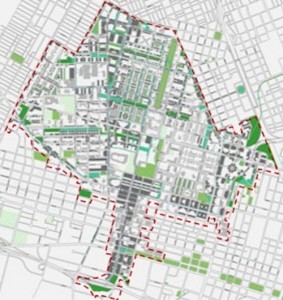
Let’s assume the National Geospatial-Intelligence Agency selects the 100-acre site in North St. Louis, over three others in the region, for its new campus, see Urban Renewal Officially Ended In 1974, Still Alive In St. Louis. Will this help or hinder the redevelopment of the surrounding blocks? The planned clearance of 100 acres will leave a one block wide strip across 22nd, to the East. To the South is Cass Ave and the former Pruitt-Igoe site, to the West is the excessively-wide Jefferson Ave. To the North will be the backs of properties facing St. Louis Ave.
Thus the biggest opportunity for positive impact on exiting development is East of 22nd Street, two corners stand out:
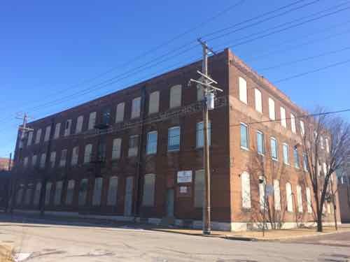
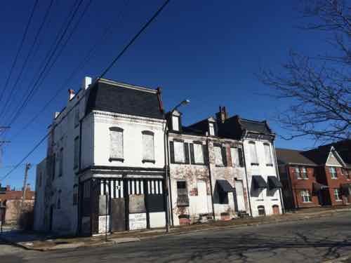
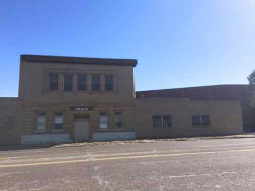
At 22nd & Mullanphy St is a vacant warehouse built in 1889. This is owned by the St. Louis Housing Authority. In the same block is the former Falstaff Brewery — successfully converted to housing a couple of decades ago — including new construction & adaptive reuse. Click image to view the Falstaff project.Two blocks north at Madison you get these three buildings owned by Paul McKee’s Northside Regeneration. The corner was built in 1904, the two on the right in 1890,.
Neither of these corners are architectural gems, but their age is a nice contrast to already built infill and the secure fortress of what the National Geospatial-Intelligence Agency would build. The old cast iron storefront at Madison might house a coffeehouse/cafe — a place for the new employment base to walk to for lunch. This could be a chance for an existing resident to become an entrepreneur, hiring others from the area.
I don’t know if the National Geospatial-Intelligence Agency works without outside contractors, if so, the 3-story 19th century warehouse could become office space. Residential is certainly another option.
If we’re going to raze a 100 acre swath of land adjacent to the long-vacant Pruitt-Igoe site we should begin thinking now about how to improve the edges. If the National Geospatial-Intelligence Agency doesn’t pick this site we’ll be area on ideas for the area, with other businesses perhaps being interested in the vacant blocks within the 100 acre site.
Great potential exists, but the private market often overlooks these less common areas that require greater creative thought.
We can all agree St. Louis must retain existing employers and attract new ones. Unfortunately, St. Louis has a habit of forgetting about urban design along the way. Let’s take a look two examples; one within the proposed 100 acres site for the National Geospatial-Intelligence Agency and one to the immediate West.
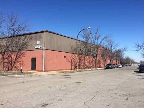
First is a warehouse currently occupied by Faultless Healthcare Linen.
This warehouse, built in 1991, will be razed if the National Geospatial-Intelligence Agency picks the city site over three others in the region.This small building from 1899 helps hide the awful warehouse behind it.
I remember when this was built in 1991 — I’d just moved to Old North St. Louis and passed it daily on Jefferson. One street was closed, the rest are faced with blank concrete block walls.
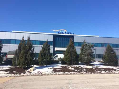
The next example is Pharmaceutical company Sensient Colors Inc., their 30-acre campus at 2515 N. Jefferson is to the West of the potential National Geospatial-Intelligence Agency site.
The newest Sensient building was built in 2004 faces Jefferson but no entrance here, no public sidewalks even.Looking NE from Elliot Ave between N. Market & Benton. The company has removed many public sidewalks from the public-right-of-way adjacent to their facility.
Never heard of Sensient? I hadn’t either, but you’ve likely seen their products — on your plate.
Most of the world’s largest food and beverage manufacturers use Sensient colors and flavors to make their household brand-name food and beverage products. (St. Louis Business Journal)
Now, the demand for natural colors is suddenly outpacing demand for synthetics, and Sensient, which makes both, is responding. It has sophisticated technology it won’t explain (it does mention doing “supercritical CO2 extraction”) to pull the coloring agents from botanicals. It has a Fusion Precise Natural Color system that lets customers specify not just a particular color, but also a subtle shade of that color. And it has a head start: 60 years’ experience with natural colors. (St. Louis Magazine)
I get it, they have trade secrets. Still, in a city people do walk to work — especially from public transit. I believe we can retain/attract employers without turning our city into a suburban office park.
The redevelopment process commonly known as Urban Renewal, in retrospect, was largely a failure:
After World War II, urban planners (then largely concerned with accommodating the increasing presence of automobiles) and social reformers (focused on providing adequate affordable housing) joined forces in what proved to be an awkward alliance. The major period of urban renovation in the United States began with Title I of the 1949 Housing Act: the Urban Renewal Program, which provided for wholesale demolition of slums and the construction of some eight-hundred thousand housing units throughout the nation. The program’s goals included eliminating substandard housing, constructing adequate housing, reducing de facto segregation, and revitalizing city economies. Participating local governments received federal subsidies totaling about $13 billion and were required to supply matching funds.
Sites were acquired through eminent domain, the right of the government to take over privately owned real estate for public purposes, in exchange for “just compensation.” After the land was cleared, local governments sold it to private real estate developers at below-market prices. Developers, however, had no incentives to supply housing for the poor. In return for the subsidy and certain tax abatements, they built commercial projects and housing for the upper-middle class. Title III of the Housing Act of 1954 promoted the building of civic centers, office buildings, and hotels on the cleared land. Land that remained vacant because it was too close for comfort to remaining slum areas often became municipal parking lots. (source)
Jane Jacobs’ 1961 book The Death and Life of Great American Cities rebuked the ongoing land clearance policies advocated by supporters of urban renewal. By the late 1960s one of St. Louis’ most prominent urban renewal projects — Pruitt-Igoe — was a disaster. Before the 20th anniversary the first of 33 towers were imploded in 1972 — urban renewal was unofficially over.
In 1974 it was officially over:
The Housing and Community Development Act of 1974 emphasized rehabilitation, preservation, and gradual change rather than demolition and displacement. Under the Community Development Block Grant program, local agencies bear most of the responsibility for revitalizing decayed neighborhoods. Successful programs include urban homesteading, whereby properties seized by the city for unpaid taxes are given to new owners who promise to bring them “up to code” within a given period—either by “sweat equity” (doing the work themselves) or by employing contractors—in return for free title to the property. Under the Community Reinvestment Act, lenders make low-interest loans to help the neighborhood revitalization process. (same source as first quote)
But forty plus years later the St. Louis leadership continues as if nothing changed. The old idea of marking off an area on a map to clear everything (homes, schools, businesses, churches, roads, sidewalks) within the red lined box remains as it did in the 1950s. The message from city hall is clear: don’t invest in North St. Louis because they can & will walk in and take it away.
Great old building near Cass & Jefferson would be razed for the campus
What are the scenarios at this point?
A) National Geospatial-Intelligence Agency selects the city option:
Businesses, residents, churches, etc are displaced.
A 100-acre swath is purchased and cleared.
The federal government builds a fortress-like campus, few workers would leave at lunch.
No benefit to the surrounding neighborhoods, access to public transit cut off by monolithic campus.
Adjacent areas now threatened as the next target for clearance, further eroding those areas.
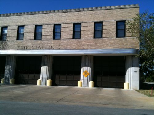
Fire Station Number 5 would remain, but because of the new campus, firefighters would be unable to quickly reach the area to the West of Jefferson/Parnell.
Fire Station 5, in the narrow strip between St. Louis Place Park and the proposed campus, would be blocked to the West.
B) National Geospatial-Intelligence Agency selects another option:
Nobody buys into this area because it’s now a known target area.
It declines further because it’s a known target area.
It’s taken later for some corporate campus.
C) An alternative if National Geospatial-Intelligence Agency selects another option:
The city/community works with Paul McKee, existing businesses and property owners to develop a plan to revitalize the Cass & Jefferson/Parnell corridors and to coordinate with a new street grid in the long-vacsnt Pruitt-Ogoe site.
The existing street grid is left fully intact.
Infill planned with a variety of residential units with a concentration of retail & office at Cass & Jefferson.
But this won’t happen, St. Louis is forever stuck in the middle of the 20th century. Clearance for a new stadium and a QuikTrip are other current examples. It has been nearly 70 years since St. Louis adopted Harland Bartholomew’s City Plan and we’ve yet to stray from the thinking he outlined.
Q: Should the City of St. Louis use eminent domain powers to assemble a site if the National Geospatial-Intelligence Agency selects the city option?
No 20 [44.44%]
Yes 14 [31.11%]
Maybe 8 [17.78%]
Unsure/No Opinion 3 [6.67%]
We shouldn’t be willing to raze 100 acres to retain earnings tax revenues. If there was hope the campus would help the surrounding area it might be a fair tradeoff, but it’ll further deteriorate and isolate. Still, this urban renewal mindset is so engrained I’m not sure we’ll ever break free of it.
Please vote in the poll, located in the right sidebar
Today’s Sunday Poll is about a tough call between residents and jobs:
Last week, the Board of Alderman approved the use of eminent domain to move people out of a 100-acre site that the National Geospatial-Intelligence Agency is considering for relocation. Now, officials are saying that property owners will have an option to stay in their homes and businesses if the NGA chooses another location.
The area, just north of the former Pruitt-Igoe site, is one of four under consideration in the region by the federal agency, which is now located south of downtown. The city is eager to keep the NGA, along with its 3,100 employees and $2.4 million in earnings taxes each year. (St. Louis Public Radio)
Glad it was clarified they could stay if the NGA selects another site, but check the fine print from St. Louis Development director Otis Williams:
Williams’ comments are merely a promise. The bill doesn’t have language mandating that homeowners can stay if the land isn’t used.
“We will not demo before we have a decision,” Williams said.
Still, Williams said there “may be a few properties” that the city will exercise rights on anyway.
The purchases will come at a hefty price. The city has allocated $8-10 million for residential property purchases, if the government chooses the city location. But several businesses, including Faultless Healthcare Linen, would cost an additional $10 to $15 million to move.
Faultless reportedly spent $12 million in 2012 to expand at the location. The city provided real estate and property tax abatement for the property. (Post-Dispatch)
So there you go, today’s question is Should the City of St. Louis use eminent domain powers to assemble a site if the National Geospatial-Intelligence Agency selects the city option?
The poll is in the right sidebar, it closes in 12 hours (8pm)
AARP Livibility Index
The Livability Index scores neighborhoods and communities across the U.S. for the services and amenities that impact your life the most
Built St. Louis
historic architecture of St. Louis, Missouri – mourning the losses, celebrating the survivors.
Geo St. Louis
a guide to geospatial data about the City of St. Louis