At a news conference at 1pm this afternoon MoDOT and Paul McKee will announce a revised plan for the long-stalled 22nd Street Parkway. The following is based on confidential materials I viewed briefly.
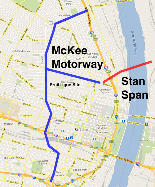
The blue represents new highway, to be called the McKee Motorway. Red is the new bridge under construction.
As part of the plan:
The resurrected 22nd Street Parkway will be connected to I-44/I-55 by replacing Truman Parkway
Ameren Electric will build a new headquarters on the former Pruitt-Igoe site, the old HQ will be razed to make room for the highway.
It would bend over and replace Jefferson/Parnell & Salisbury and connect with I-70.
A connecter will replace Cass Ave to reach the new bridge.
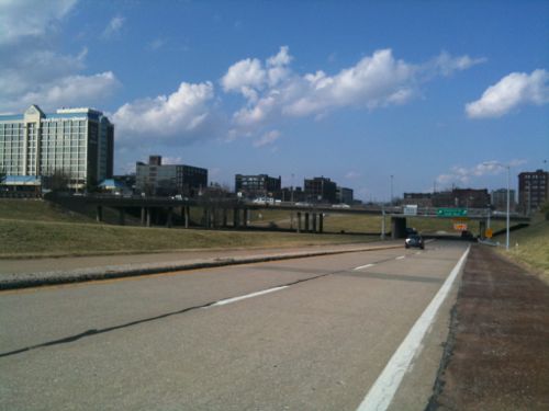
ABOVE: Only part of a planned highway loop around downtown was built, a huge waste of land to the west of Union Station.
From the embargoed press release:
“The solution to redeveloping north St. Louis is having much more highway frontage” said developer Paul McKee, “plus the new McKee Motorway way will serve as a divider to keep unwanted types out of my development area.”
Of course I’m opposed to this plan! Do they think we are fools?
Readers in the poll last week didn’t select any one option by a majority. The three routes presented as options, two being considered and another I’ve been advocating for years, each received a similar number of votes.
Q: My preferred route for a streetcar line is…
Option 2: Olive/Lindell>Euclid>Forest Park Blvd>Taylor>Lindell 35 [29.66%]
New option: Olive/Lindell to Vandeventer to Delmar to Loop Trolley 29 [24.58%]
None, don’t built a streetcar line 12 [10.17%]
Other: 10 [8.47%
Unsure/No Opinion 1 [0.85%]
The ten other answers were:
Use the old Hodiamont Streetcar right of way
grand blvd
Olive/Lindell>Euclid>Forest Park Blvd>Vanderventerr>Lindell/Olive
Street cars are a joke. They are a waste. Busses offer far more flexibility.
Use the old Hodiamont street car right of way.
Continue on Lindell to Debaliviere/Loop Trolley connection.
Middle-upper income routes to replace cars.
Link “downtown” only by s.cars: riverfrt. to Jeff Ave,, Delmar to Soulard.
free, downtown loop, between Tucker & Broadway
Option 1 but utilize Market and Forest park instead of Olive/Lindell
When streetcars were first installed it was a private effort by real estate developers to make it easier for buyers to reach new development:
The Gravois-Jefferson Streetcar Suburb Historic District is located within the boundaries of the City of St. Louis, Missouri. The -715-acre District is a triangular area generally bounded by the intersection of Gravois and South Jefferson Avenues at the north, South Jefferson Avenue and South Broadway Street (south of Chippewa Street) on the east, Meramec Street on the south, South Grand Boulevard on the west, and Gravois Avenue on the northwest.’ Gravois Avenue is a major arterial street and historically served as a wagon, streetcar, and vehicular transit corridor. South Jefferson Avenue also was and is a major transportation corridor. Meramec Street is a major collector street. Mixed commercial, institutional, and residential use along these major city thoroughfares visually and historically defines the survey area. (National Register nomination PDF)
Today funding streetcars in developed urban areas takes more than available right-of-way, it takes enough demand to justify the investment in infrastructure. Often this means connecting some big dots, the in between will fill in over time with proper land use controls. The problem in St. Louis is our big dots are generally east-west between downtown and Clayton. What big dots exist north & south to guarantee ridership on a daily basis?
Grand has a few dots:
VA Hospital
Grand Center/SLU
Grand MetroLink
SLU Hospital
Okay, suppose you connect these via streetcar — that’s a mile and a half length. Not bad, but you’d still have to run the #70 (Grand) MetroBus to reach areas north and south — an additional 7.5 miles. Even my longtime preferred route of Olive/Lindell to Vandeventer to Delmar doesn’t have enough dots to get funding.
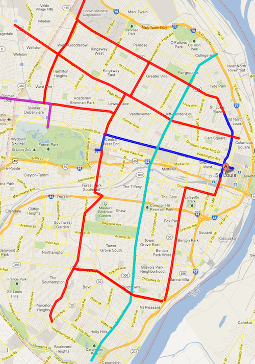
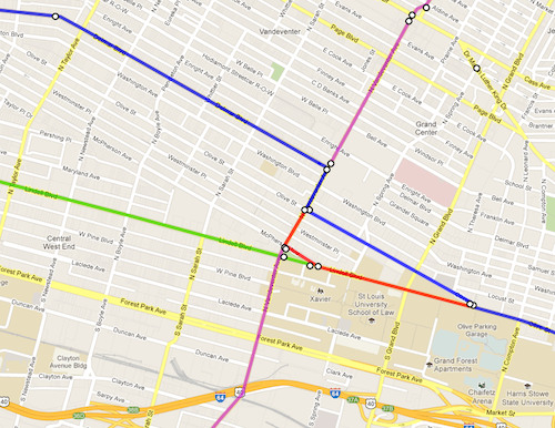
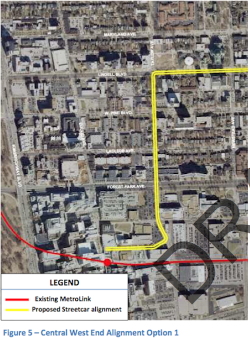
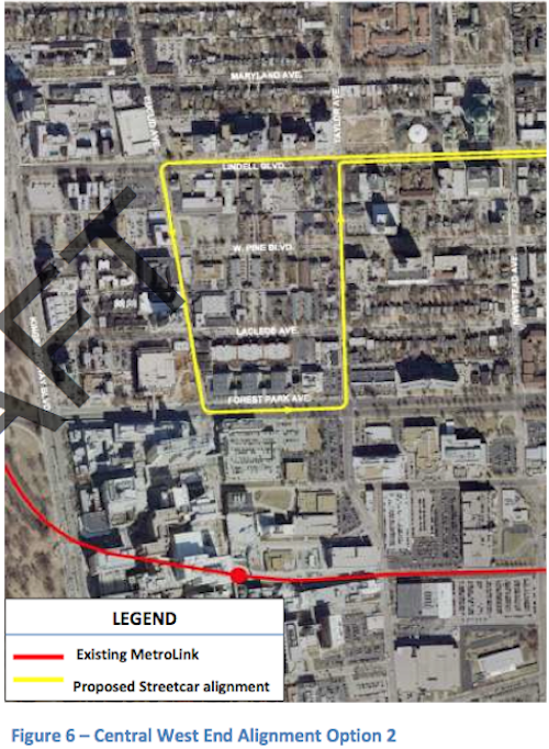
But between the Option 1 & 2 being considered I have a strong preference for #1 — the double track on Taylor Ave option rather than the Euclid/Forest Park/Taylor loop.Establishing a double track on Taylor Ave sets up a perfect scenario for north-south expansion. Below is one concept:
Purple = Loop Trolley, Teal = #70 Grand BRT, Blue = Proposed Streetcar, Red = Possible Future Lines. Click image to view map in Google Maps
The dots aren’t there for an initial north-south line but extending a couple of miles here and there every few years would eventually build a system. The current proposal calls for a north-south piece at 14th Street, going up to St. Louis Avenue. The double track on Taylor of Option 1 provides an ideal spot for a second north-south line further west. Expansion could happen to reach new development projects.
Yes, what I’ve shown above would take decades to construct. That’s how long-term planning works. For further reading on streetcars please see a 65-page literature review of Relationships Between Streetcars and the Built Environment.
Plans were presented to the public last week to built a 7-mile modern streetcar line in St. Louis that would:
Circulate in the downtown central business district.
Head west on Olive/Lindell past Midtown to the Central West End.
A north-south segment would connect at 14th Street & Olive, initially going north Florissant Rd to St. Louis Ave. and south to the Civic Center MetroBus Center/MetroLink light rail.
Open in 2016/17.
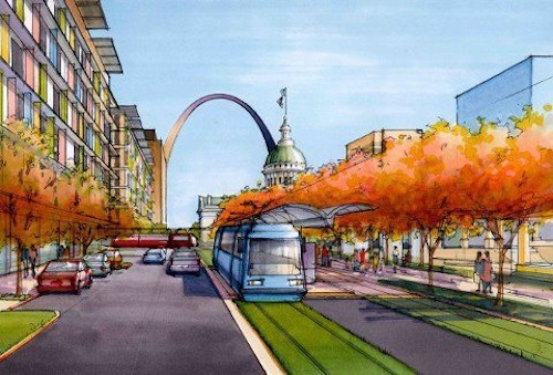
Artist rendering of streetcar in downtown St. Louis
Metro is part of the planning process and this would become part of our transit system. But I know some of you still question the effectiveness of the streetcar over the bus. To be fair, here is a skeptical view that I happen to agree with.
Streetcars that replace bus lines are not a mobility improvement. If you replace a bus with a streetcar on the same route, and make no other improvements, nobody will be able to get anywhere any faster than they could before. This makes streetcars quite different from most of the other transit investments being discussed today.
Where a streetcar is faster or more reliable than the bus route it replaced, this is because other improvements were made at the same time — improvements that could just as well have been made for the bus route. These improvements may have been politically packaged as part of the streetcar project, but they were logically independent, so their benefits are not really benefits of the streetcar as compared to the bus. (source – highly recommended)
He’s right that streetscape improvements are just as important as the mode of transit, but funding realities mean a complete makeover of 7 miles for a bus isn’t very likely. Even if it was, a streetcar is a better choice for other reasons:
Streetcar vs. Bus
Buses are excellent local and regional public transportation options, but they will do little to spur redevelopment and economic investment in Downtown LA. This is due to the inherent flexibility of bus service, as routes change regularly to accommodate varying needs; in addition, buses contribute to nerve-racking pedestrian experiences due to heavy street-level emissions and noise pollution that discourages active use of sidewalks. Streetcars do the exact opposite. They provide developers and business owners certainty that the routes will not change, and are considered preferable to buses by residents, visitors, and employees as they offer more amenities, highly reliable routes and timetables, and enhanced urban experiences.
Buses and streetcars do, however, work together to connect access points within regional transportation networks. For example, sidewalks can be designed to specifically accommodate both vehicle configurations; in return, a transit stop effectively doubles its value within a regional transportation network. (LA Streetcar)
And…
While it’s true that streetcars require a much larger initial capital investment than buses, that capital cost is offset by significant operational savings year to year. In the long term, streetcars are more affordable as long as they are used on high ridership routes.
Streetcars have higher passenger capacity than buses (even bendy ones), which means that if there are lots of riders on your route, you can move them with fewer vehicles. Fewer vehicles means more efficient use of fuel and fewer (unionized, pensioned) drivers to pay.
Streetcar vehicles themselves are much more sturdy than buses, and last many decades longer. While buses must generally be retired and replacements purchased about every 10 years, streetcars typically last 40 years or more. For example, Philadelphia’s SEPTA transit system is still using streetcar vehicles built in 1947. (Washington Post — recommended)
Even in Portland the value of streetcars have been debated, critics questioning claims of Mayor Hales:
So that brings us to the ruling. Hales said “streetcars carry more people than buses … you attract more riders who don’t ride transit now, and actually the operating costs are not any greater than the bus.” Whether these arguments make a persuasive case for the necessity and usefulness of a streetcar system is, of course, up for debate. The statement itself remains factual. While, there’s some missing context, it’s nothing significant. We rate this claim True. (PolitiFact Oregon)
For a detailed look at operating costs of streetcars vs bus click here. Labor tends to be a big factor why streetcars are cheaper to operate.
For the poll this week I want you to vote on your preferred route. I’ve included “don’t build” as an option as well as my idea of Olive to Vandeventer to Delmar: described here.
ABOVE: Blue was my original route idea, red is my variation, green is continuing on Lindell, purple is a north-south line on Vandeventer. Click image to view post. Note: This image added to this post at 10:30am on 3/10/2013.
The poll also has the two options from the study (p17):
Option 1 includes double track on Taylor south to Children’s Place/CWE MetroLinkOption 2 continues to Euclid, to Forest Park Blvd to Taylor back to Lindell
My views on a St. Louis streetcar are evolving, more on Wednesday March 20. The poll is in the right sidebar (mobile users need to switch to the desktop layout)
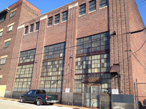
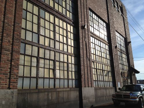
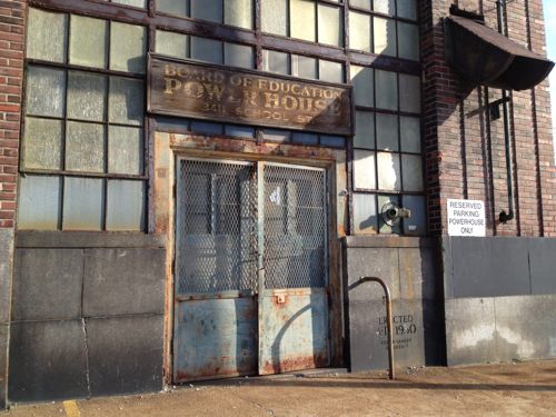
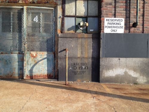
Decades ago basic industrial buildings had a sense a sense of design I find very appealing today. For example, the Board of Education Power House at 3614 School Dr:
ABOVE: While not the most ornate building, it has a distinctive look.ABOVE: I’m a huge fan of steel industrial windowsABOVE: The sign & entry, even rusted, is visually appealingABOVE: I like easily knowing the date a building was built
This makes me wonder if people 80+ years from now will find our current industrial structures charming. Doubtful.
Last July I posted about a New Coffeehouse Opening Soon on Page Blvd Just East of Grand Ave. It took a white while to open but last month it finally did. A few days ago I met someone there and returned for lunch. The concept is simple, a nice neighborhood coffeehouse that hires employees from the area.
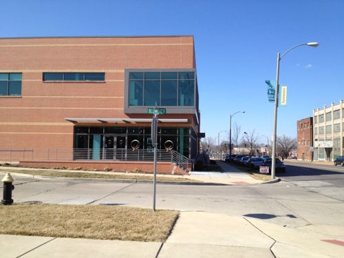
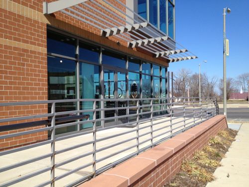
ABOVE: Chronicle Coffee is located in the corner of a building that also houses the St. Louis Public Housing Authority and a PNG Bank branch. Click for Google Maps.
But how do you make such an enterprise financially viable? During my visit I was able to chat with the owner, turns out the answer is through acquisition!
Rick Milton, owner of Northwest Coffee Roasting Co., has sold his company to Jason Wilson, the owner of Chronicle Coffee. Chronicle is located just north of Grand Center at 1235 Blumeyer Ave. The sale, completed in December, includes both the Northwest Coffee roasting operation as well as Northwest Coffee cafes in Clayton and the Central West End. (Sauce Magazine)
By buying the well established Northwest Coffee Wilson has quality coffee for Chronicle and a good place to train new employees.
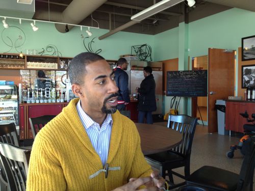
ABOVE: Owner Jason Wilson sat down with us to talk about Chronicle, Northwest, and creating jobs in a community in need of more employment opportunities.ABOVE: Tables & chairs will arrive next month
One wall of Chronicle Coffee includes enlarged black & white prints of the former Blumeyer public housing project that once occupied the immediate area.I know I’ll return when I’m nearby. Wilson is finalizing plans for their grand opening later this month.
AARP Livibility Index
The Livability Index scores neighborhoods and communities across the U.S. for the services and amenities that impact your life the most
Built St. Louis
historic architecture of St. Louis, Missouri – mourning the losses, celebrating the survivors.
Geo St. Louis
a guide to geospatial data about the City of St. Louis