In 1990, at just 23, I fell in love with St. Louis and its quirky street grid. I hadn’t yet been to New York or Chicago but I knew many big cities had rigid orthogonal grids — nothing but right angles.
St.Louis’ grid, on the other hand, had right, obtuse, and acute angles. This meant interesting views from various directions, buildings designed to fit into the odd-shaped parcels. Some streets follow old trails, the neighborhoods built up around the meandering paths.
I simply adore this about St. Louis.
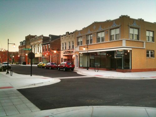
In my first 6-9 months here I made my way along North & West Florissant Avenue as it makes it way up through North St. Louis. My destination was O’Fallon Park — the neighborhood and city park.
Right before the park was the remnants of once-thriving commercial district. I’ve been back there many times over the years in a car, bike, bus, and motor scooter.
From the bus on August 5, 2017, looking at West Florissant Ave & Harne Ave. Click image to view in Google Streetview
This old commercial area is the center of a new revitalization project called “The City District.”
Phase One During the $34 million Phase One, 66 parcels will be demolished and the land will be reallocated for new construction of retail, homes and community greenspaces. More than 50 percent of these properties are currently vacant. The construction team is working on master plan and design development and bidding. Demolition will begin in March. Kwame Building Group is serving as the construction manager and program manager. The architect is Jackson Design Group.
In Phase One, the construction team also will build City Plaza, which will create vibrant shopping and recreational opportunities and a thriving local labor force. The commercial center will feature extensive retail and office space, including a grocery store and bowling alley.
Phase Two The O’ Fallon Neighborhood is home to some of St. Louis’ largest and most historical homes rivaling the size and stylings found in the Central West End and surrounding Tower Grove Park and Forest Park. In Phase Two, $1 million will be invested in rehabilitating 26 existing homes. Large single-family homes will be converted into multi-use rental properties while retaining their architectural history. A $24 million project will construct new single and multi-family homes.
Culturally competent and equitable redevelopment practices will be central throughout the five-year project. The KWAME team is committed to maximizing MBE/WBE and local firm participation. The project team has established a partnership with the City of St. Louis to increase community safety and security focused on community competent policing. Existing infrastructure will be reimagined to improve and promote public transit and pedestrian accessibility. (Kwame Building Group)
My initial thoughts are generally positive, the area desperately needs investment after decades of disinvestment by whites and then blacks. I’m very glad this effort is coming from the black community, not an old white suburban developer. It’s a very good thing they’ve given this commercial district a name — that’s important for creating a positive identity.
However, I’m very concerned about demolition of currently occupied structures. Reallocating land sounds like making wide suburban lots rather than the existing narrow lots with garages and services off the alley. How the large triangle created as West Florissant splits is treated will be very important. It’s all asphalt now. Lots of unanswered questions.
Wisely they’ve said it will take multiple phases and five years, though I expect it’ll take even longer. And that’s ok, it didn’t decline overnight so we can’t expect an immediate reversal. I’m looking forward to seeing more details.
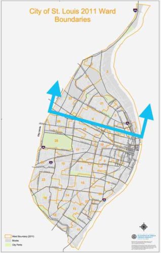
The six wards on the top 1/3 of the city had lower registered voters in 2016 & 2020.
As I pointed out recently, north St. Louis continues experiencing population loss. In my post on the election results I wrote:
Despite the increase in registered voters, six contiguous north city wards (1,2,3,4,21,22,27) had decreases in registered voters. These same six also had decreases in 2016. When the 2020 census numbers are released next year we’re going to see population loses in the north side, but increases in the central corridor — the same pattern happened a decade ago. The overall increase in registered voters tells me the overall population loss slowed again or we might even see a very slight increase in population. A loss is more likely.
Overall the city had increased voter registration compared to 2016, so something is going on. Once we have the detailed census results we’ll get a clearer picture what is happening.
In the meantime I have some thoughts on this subject.
The 1940 census saw a decline from 1930 — those who could afford to move to the new suburbs were doing so in large numbers.
Peak population in St. Louis in 1950 was around 856k. That population exceeded the physical capacity of our housing units — major overcrowding occurred in the oldest housing. Housing in the NW & SW was only 20-30 years old during the 1950 census, it likely wasn’t overcrowded. It was the 19th century housing that was overcrowded. The increased population masked an underlying problem — the white middle class was fleeing rapidly. Rural/poor whites & blacks looking for work after WWII made the census numbers look good but it was a huge shift in people.
In the seven decades since we’ve razed a significant percentage of the 19th century structures for highways, urban renewal projects, and due to abandonment. During this time the total population each census was less than the previous census. Initially it was large scale and widespread, but has slowed. Within a few decades all white neighborhoods became all black neighborhoods.
After the 2010 census we saw increased population in the central corridor (downtown west to city limits) but losses north and in parts of south St. Louis. I don’t think we’ll ever see widespread abandonment south of the central corridor. So much has been rehabbed — just too much invested to walk away. This is not to say that small areas on the southside won’t see losses, they very well could. Another thing we saw in the 2010 census was the black population dropped to just below 50% of the total, the white population remained unchanged as a percentage.
The six wards that make up the northern third of the city, on the other hand, are highly likely to see significant losses in the 2020 census results. These losses will most likely account for the majority of the overall population loss of the city.
What’s happening is the residents of these six wards are likely finding better housing elsewhere — either in the rest of the city or in St. Louis County. Population in the St. Louis region has long shifted around in search of better housing. What’s new is in these wards we are seeing a significant shift out with no new group shift in. When older homeowners die their kids don’t want the dated old family home.
To be sure there are some very nice pockets within these six wards with well-maintained houses, tree-lined streets, etc with relatively dense populations. These islands are in contrast to the food/job deserts of the rest of the wards. Large non-residential sites include O’Fallon & Fairgrounds parks, Bellerive & Calvary cemeteries, and the contaminated government facility on Goodfellow occupy a lot of land, but a lot of the land is where buildings used to exist.
With these longtime wards emptying out it presents problems for redistricting next year. Ideally political boundaries are drawn to be compact, ideally square in shape. But you also want wards to reflect the demographic makeup of the population. After redistricting each ward represents roughly the same amount of people so the number of wards doesn’t matter as much when a third of the city is being vacated while the two-thirds is stable or increasing. It’s going to be challenging keeping the same number of majority black wards. I could see a black alderperson representing a diverse south city ward. The next redistricting will reduce the number of wards from 28 to 14.
In a future post I’ll share my thoughts what St. Louis should do to counteract the increasingly empty third of the of the city.
It has now been a decade since a 33-year mistake was corrected. During the 1960s & 1970s removing a street to create a “pedestrian mall” was a magic bullet tried by cities coast to coast. Almost fall failed.
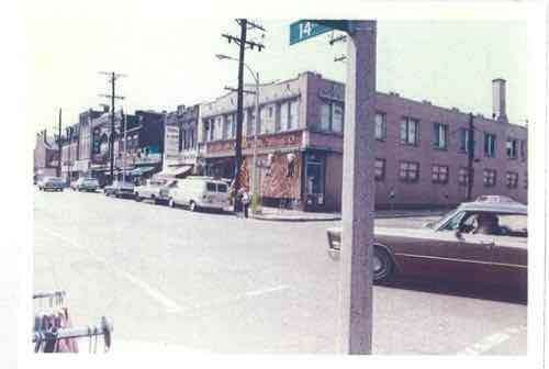
In the early 1970s North 14th Street merchants began looking for solutions to a decline in sales as residents of the surrounding near north neighborhood left for better housing elsewhere.
From a May 1972 Washington University graduate thesis
The solution, they thought, was to mall 14th Street. Some buildings behind the street were razed to create large surface parking lots, so former residents could drive back to their old neighborhood to shop at chains like JC Penny & Woolworth’s and local businesses like Sobel’s Furniture.
Open air and enclosed malls were attracting more and more customers so remaking a decades-old neighborhood shopping district to emulate suburban malls would attract customers. Well, that was the theory that led to hundreds of streets nationwide being malled.
More like mauled.
The new 2-block long mall opened on March 2, 1977. Two blocks of North 14th Street were closed to vehicles, from Warren Street on the south to St. Louis Ave on the north. The one cross street, Montgomery Street, was also closed. See current map.
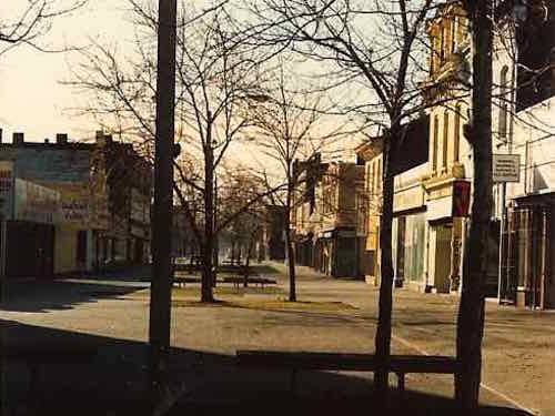
By the time I first saw it in the Fall of 1990 very few businesses remained.
Looking south on 14th, Spring 1991
By the Spring of 1991 I was living in the Murphy-Blair neighborhood, the local group was working to rename it Old North St. Louis. The neighborhood located just north of downtown St. Louis was a separate village 1816-1841, when it was annexed by a growing St. Louis.
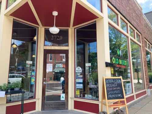
Two business that were were just beyond the mall were Marx Hardware (Est 1875) and Crown Candy Kitchen (Est 1913), both are still in business.
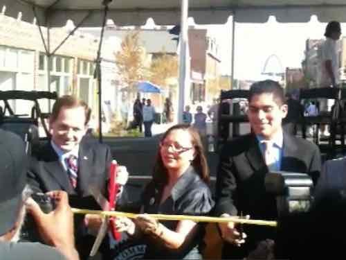
I left the neighborhood in August 1994, but others finally figured out how to put together a project to both renovate the buildings that remained and put back the street. I applaud all involved for their perseverance.
The ribbon cutting was held on July 29, 2010
After the ribbon cutting & celebration traffic didn’t immediately begin driving up & down 14th Street. The new streetlights were delayed, so the city’s Streets Dept wouldn’t let cars use the new street. Within a few months the lights and a few other punch list items were completed.
The former Woolworth’s at 14th & Montgomery in 2010.
In the decade since the reopening new occupants of the storefronts have changed, retail is a struggle everywhere. The spaces aren’t empty, which is important. The street trees have matured nicely.
Old North Provisions diagonally across from Crown Candy Kitchen in August. Click image to see their website in a new tab.
Some say the mall helped keep these buildings from being destroyed, but I think had the mall not been built the street might have been slowly brought back one business at a time, like others in St. Louis.
Homelessness is a problem coast to coast — in big cities and in small towns, in downtowns and in the suburbs. Often it’s invisible, other times it’s too visible. One of the groups who find themselves homeless are our veterans, men & women who served our country but then fell through the big holes in what’s left of our safety nets.
The U.S. Department of Veterans Affairs (VA) states that the nation’s homeless veterans are predominantly male, with roughly 9% being female. The majority are single; live in urban areas; and suffer from mental illness, alcohol and/or substance abuse, or co-occurring disorders. About 11% of the adult homeless population are veterans.
Roughly 45% of all homeless veterans are African American or Hispanic, despite only accounting for 10.4% and 3.4% of the U.S. veteran population, respectively.
Homeless veterans are younger on average than the total veteran population. Approximately 9% are between the ages of 18 and 30, and 41% are between the ages of 31 and 50. Conversely, only 5% of all veterans are between the ages of 18 and 30, and less than 23% are between 31 and 50.
America’s homeless veterans have served in World War II, the Korean War, Cold War, Vietnam War, Grenada, Panama, Lebanon, Persian Gulf War, Afghanistan and Iraq (OEF/OIF), and the military’s anti-drug cultivation efforts in South America. Nearly half of homeless veterans served during the Vietnam era. Two-thirds served our country for at least three years, and one-third were stationed in a war zone.
About 1.4 million other veterans, meanwhile, are considered at risk of homelessness due to poverty, lack of support networks, and dismal living conditions. (National Coalition for Homeless Veterans)
The above organization lists some stunning statistics:
DEMOGRAPHICS OF HOMELESS VETERANS
11% of the homeless adult population are veterans
20% of the male homeless population are veterans
68% reside in principal cities
32% reside in suburban/rural areas
51% of individual homeless veterans have disabilities
50% have serious mental illness
70% have substance abuse problems
57% are white males, compared to 38% of non-veterans
50% are age 51 or older, compared to 19% non-veterans
It should be clear that homeless veterans are a big group. Programs to assist the general population might help some, but a targeted approach will yield better results.
Veteran homelessness is related to another problem: veteran suicide.
Veterans with a history of homelessness are five times more likely to attempt suicide than other veterans, a new study by researchers at Yale and the U.S. Department of Veteran Affairs has found. (Yale)
The solution to homelessness appears to be getting them off the street and treatment for issues like substance abuse. Such treatment won’t work while on the street looking for their next meal or where to sleep. Housing becomes the key, but what kind?
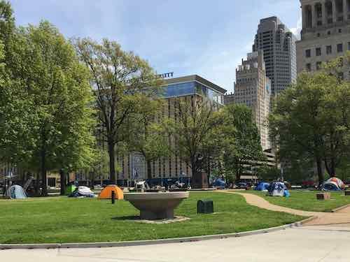
Tents for homeless, downtown St. Louis in April
In the past SROs (single room occupancy) were an important housing option, but these have mostly disappeared. Tent cities are an option, but those lack privacy, showers, etc. Tent encampments are often run off from the land where they spring up. Five years ago a group opened Freedom House, a renovated apartment building, for homeless veterans. See Housing For Homeless Veterans Nearing Completion At 4011 Delmar.
A relatively new nonprofit, based in Kansas City, is trying a solution other cities have utilized: tiny houses. Veterans Community Project (VCP) now want to expand into St. Louis, focused on helping veterans with anything they need. Apparently accessing services available through the Veterans Administration (VA) isn’t easy, so they help veterans navigate the bureaucracy. They can also help veterans get other services outside those offered through the VA. And 50 tiny houses will give the men & women the security & stability they need to rebuild their lives.
At the land dedication event on friday a couple of speakers mentioned eradicating the problem of homeless veterans in Missouri. Sounds good, but homeless veterans exist outside of the Kansas City & St. Louis metro areas. While I’m skeptical about any claim to eradicate homelessness, this project will potentially make a significant dent in our total homeless population.
Let me walk you through their proposed project, then I’ll share a few areas of concern.
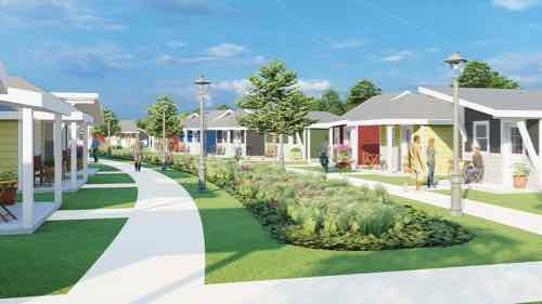
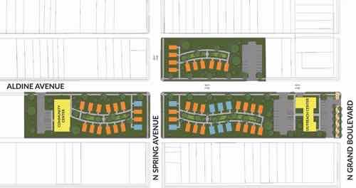
Located on a 5-acre property in the heart of the Jeff Vander Lou neighborhood, the Veterans Community Project campus includes a village of tiny houses for Veterans experiencing homelessness and a Veterans Outreach Center to provide walk-in support services for any Veteran in the St. Louis metro area.
VCP Village
VCP Village is a specialized community of 50 tiny homes with on-site, wraparound support services designed to equip Veterans with the tools needed to return to a stable, prosperous, independent life.
Each tiny house provides everything a Veteran needs to live with dignity and security; new furniture, appliances, housewares, bedding, personal items, and utilities – all free of charge. The homes offers sanctuary and the emotional space needed for each Veteran and VCP’s specially-trained team to thoroughly address the underlying causes of his or her homelessness.
With the support of their case managers and battle buddies, Veterans work to achieve incremental, lasting results in the areas of health and wellness, income stability, education and training, fiscal understanding, and the development of a personal support network. Once the Veteran’s individual goals are met, VCP assists him or her in securing a permanent housing solution and transitioning to a new life.
The Veterans Outreach Center
Located on Grand Ave, the Veterans Outreach Center is a “one-stop” shop for any Veteran requiring support services such as emergency rent and utility assistance, food and hygiene kits, employment supports, military documentation and benefits navigation, and case management.
The project is modeled after VCP’s Kansas City model which has already served more than 4,100 at-risk Veterans and successfully transitioned more than 40 formerly homeless Veterans into permanent housing since its opening in 2018. (VCPSTL)
You can see an early construction aerial of their KC village here, so let’s take a look at their St. Louis proposal.
Three groupings of tiny houses would face a central area, to create the village feel.They want to build on 3 areas around Aldine Ave & Spring Ave, west of Grand (right). Their Outreach Center is on the right, at Grand. The yellow building on the left is the village community center.
There’s a lot to like about their proposal:
The services to veterans seems very important, even if not homeless. Too many serving the homeless offer just one part of what they need, sending them off to find the rest. This will hopefully result in a higher success rate.
It’s close to the VA Hospital on Grand.
The number of separate structures is roughly equal to what was here in 1909 (See Sanborn map).
Tiny houses can be on wheels, modular, or built on site. This is the latter. These are permanent structures.
Tiny houses are psychologically better than other transitional options because they immediately help the individual see themselves living in their own place, independent of others. It’s a baby step toward an apartment.
Case managers will help keep these vets on track.
There’s no rent, no limit how long they can stay.
Ugly mostly vacant lots backed up to auto salvage businesses aren’t likely to be used for anything, especially new housing.
No public streets vacated!
Obviously I’m a believer in tiny houses for transitional housing for the homeless, but I do have a problem with a couple of things and I have some suggestions.
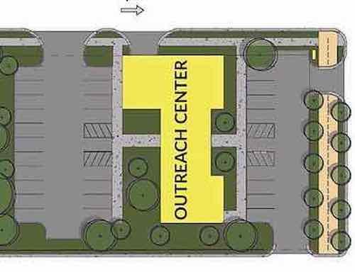
Grand Boulevard is our longest north-south corridor, with the busiest bus route (#70). Pedestrians use the bus, and as part of an urban area all new construction along Grand should be urban in placement and massing. First, here’s how they plan to face Grand.
Unfortunately they’ve shown the outreach center building set back behind parking, rather than up to the public sidewalks. It also requires 3 driveways interrupting the sidewalk. Very suburban design, totally inappropriate for an urban neighborhood with heavy pedestrian use.This is easily addressed by designing the building to be located at the corner, with the entrance directly on the Grand sidewalk. Ideally it would be 2-stories, or 1-story with a raised roof area at the corner.
Rather than a curb cut leading to a garage door, this function should be off the parking lot — not interrupting the public sidewalk. The sidewalk along Grand should be as wide as possible, with tree wells, not tree lawns. This allows people who arrive by car to park in the parking lane and then step onto pavement, not grass. Same for the Aldine Ave side of the building.
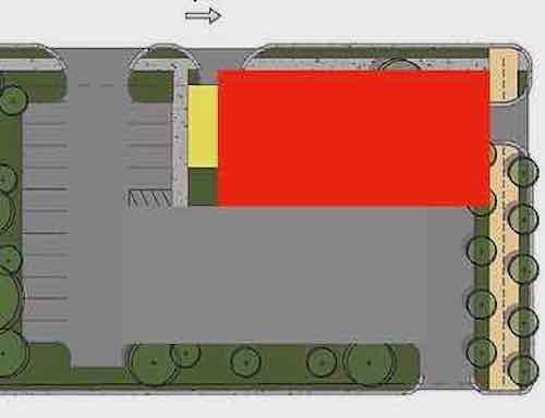
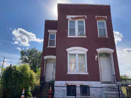
From both streets you see the blank backs of the houses — no eyes on the streets.3708 Aldine Ave will be razed. It was built in 1889. In the last decade two wood frame houses to the right were razed. At least this block has a history of different heights and materials.
In addition to the above issues I have some suggestions to improve the project.
Make the Aldine Ave 2-way as shown on the site plan.
Corner curb bulbs to narrow streets, slow drivers. Also reduces the crossing distance, adds planter opportunities.
Add some bioswales/rain gardens to Aldine Ave to catch water and reduce the amount of paving. With parking lanes Aldine Ave is too wide.
Plan for internal walkways to alleys so residents can take their trash/recycling to the dumpsters.
The main thing I’d like to see is the outreach center building be up against the Grand sidewalk — not pushed back behind parking.
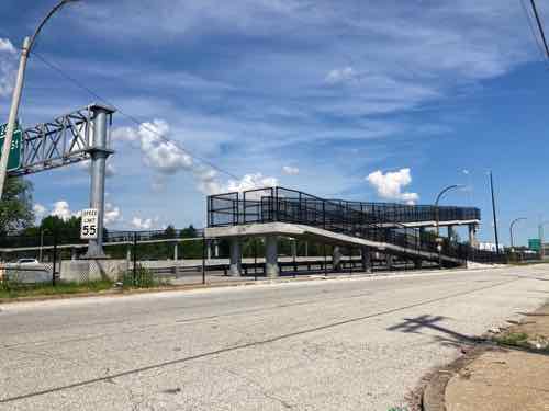
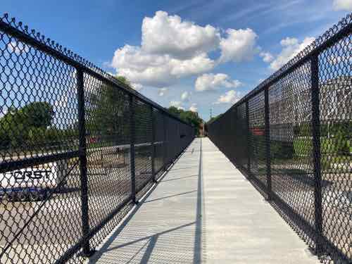
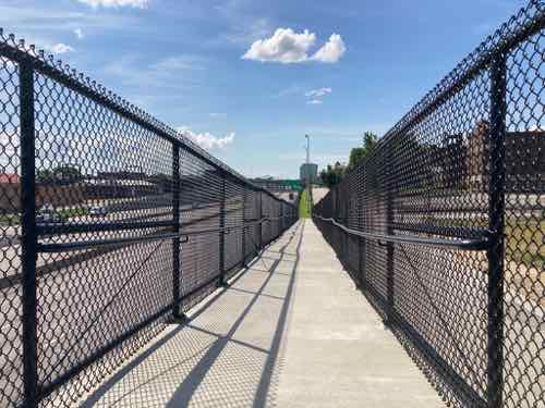
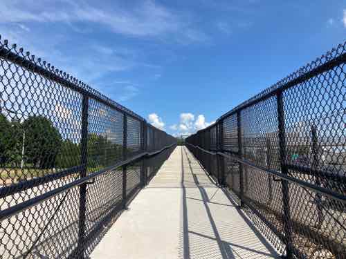
August 6, 2020Accessibility, Featured, North City, WalkabilityComments Off on Checking Out New Pedestrian Bridge Over I-70 Connecting Old North St. Louis and Near North Riverfront Neighborhoods
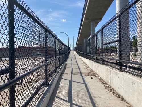
In December 2018 MoDOT temporarily closed I-70 to remove an old pedestrian bridge at North Market Street. A similar pedestrian bridge was removed from over I-44 at Marconi Ave, and at other locations. Yesterday I checked out the new ADA-compliant replacement over I-70.
The East side of the new pedestrian bridge, along Northbound 10th Street, has a switchback ramp.
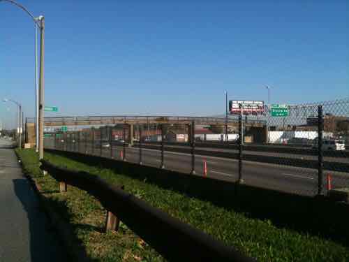
Before getting into the new bridge we should look at what it replaced. Interstate 70 was built decades before the Americans with Disabilities Act of 1990, so the old pedestrian bridge had stairs on each side.
This 2010 photo is from the West side along 11th Street. The stairs on each end went down in opposite directions.
Stairs make such a bridge impossible for those of us who use wheelchairs, but also difficult for people who walk using a cane or walker. They’re also a challenge to a parent pushing a stroller, cyclists, etc.
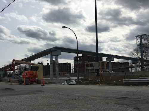
In April 2019 I snapped this image of construction on the new bridge as I was driving by. Yes, I drive too!
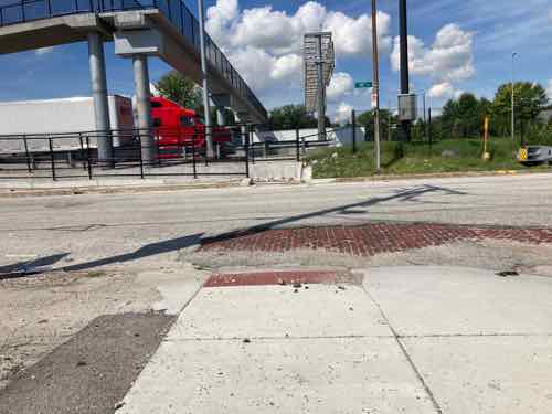
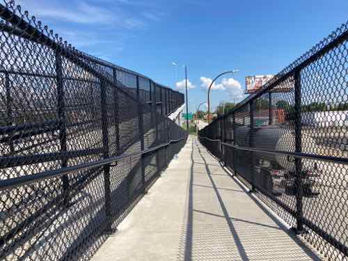
Yesterday’s weather was so nice I decided to check out the completed bridge. It was 1.2 miles just getting there from our apartment near 7th & Cass Ave. I did encounter missing curb ramps in a few places — often missing sidewalks. But I made it.
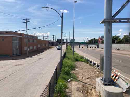
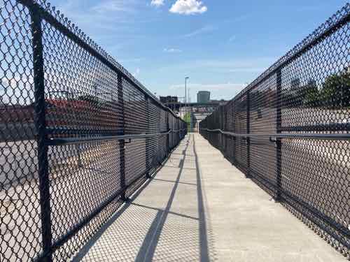
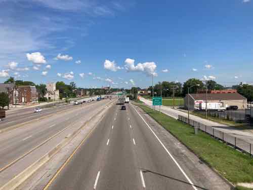
The access point on the East side of I-70 is at North Market Street. There is no painted crosswalk, no signs warning drivers to yield to pedestrians. No curb bulbs to narrow the crossing distance. Nothing. 10th Street traffic is one-way northbound — and it is fast.Once safely across 10th Street you see trash has accumulated. The city has equipment to clean streets but tight spots like this don’t get cleaned.From the base looking up the ramp to the landing. I use a power chair which had no problem with the incline. Being ADA-compliant means the maximum level should be acceptable to person using a manual wheelchair. Every so often there are level spots to give someone s rest.From the landing, looking back down.Looking South from the landingFrom the very top looking back at the landingLooking East at North Market Street from the top.Looking West across the level top of the bridge.Looking North at Northbound I-70.Looking South at Northbound I-70. The switchback ramp can be seen on the left.Looking South at Southbound I-70. The straight ramp on the West side (11th Street) can be seen on the right.From the West end of the bridge you get an excellent view of Jackson Place Park. This was the center of three circles in the original plan of the separate Village of North St. Louis.Looking South down the straight ramp on the West side (11th Street).Looking back up from the bottom.At the bottom you look across 11th Street at Monroe Street. A new curb ramp was built across the street. Like the other side, 11th is one-way and there is no crosswalk markings, signs, etc.Back up toward Jackson Place Park you can get an overview of the West side.
It is nothing fancy, but it gets the job done. Highways divided many neighborhoods, many previously connected streets permanently severed. I have no idea how much this cost, but it was worth every penny. The highway is still an at-grade divider at this point, but the bridge makes it possible for everyone to safely to cross over it.
Once the current pandemic is over I’ll take the bus to other new pedestrian highway bridges so I can compare. Yesterday I explored in Old North, got takeout from Crown Candy, and returned home 3.5 hours after leaving. Roundtrip was about 3 miles.
AARP Livibility Index
The Livability Index scores neighborhoods and communities across the U.S. for the services and amenities that impact your life the most
Built St. Louis
historic architecture of St. Louis, Missouri – mourning the losses, celebrating the survivors.
Geo St. Louis
a guide to geospatial data about the City of St. Louis