A decade ago the National Geospatial-Intelligence Agency (NGA), located near Anheuser-Busch brewery, announced it intended to build a new campus. If you’re not familiar with the NGA here’s how they describe themselves:
The National Geospatial-Intelligence Agency (NGA) delivers world-class geospatial intelligence that provides a decisive advantage to policymakers, military service members, intelligence professionals and first responders.
Anyone who sails a U.S. ship, flies a U.S. aircraft, makes national policy decisions, fights wars, locates targets, responds to natural disasters, or even navigates with a cellphone relies on NGA.(NGA)
b
b
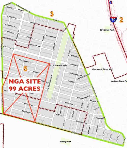
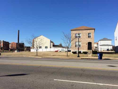
The NGA site is a big chunk of the St. Louis Place neighborhood. The latest documents call it 97 acres, not 99 on this image used in a prior post.
b
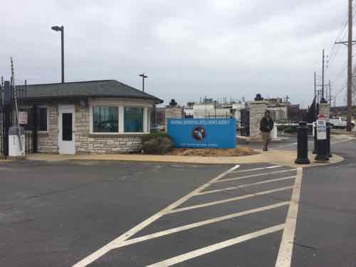
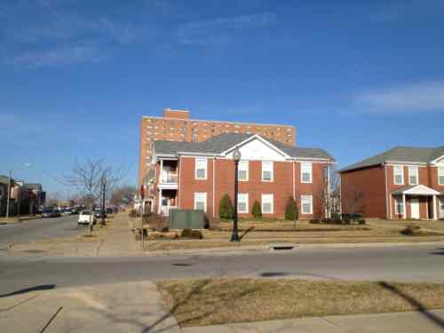
I just couldn’t see how building a large high security military facility was going to be a positive for the immediate area — people would drive in for work, maybe drive out for lunch, then drive home at night. Having seen the secure entrance to their current facility numerous times it’s not welcoming, nor pedestrian oriented.
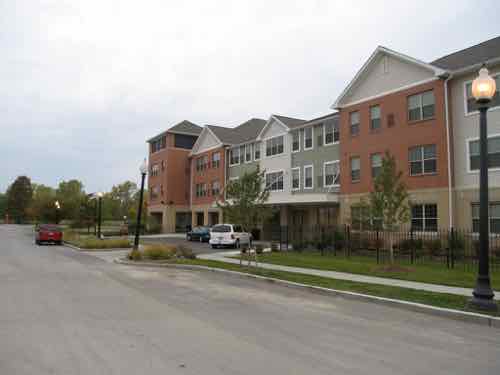
Current NGA entrance, 2015This February 2016 concept was prior to the final decision of the St. Louis Place site in April 2016
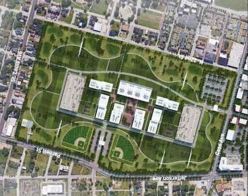
In the concept above we see structures in the center of the site, not edges — for security. In the very center is 7 separate buildings, with a parking garage to the north & south (left & right). If you’ve been watching the construction taking place you know NGA’s actual design is different than St. Louis’ concept rendering. Again, the concept above was part of the successful St. Louis effort to have the site at Jefferson & Cass selected.
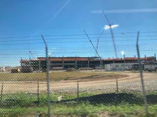
Construction of a parking garage in September 2021, as seen from the #04 Metrobus
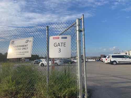
Last month us residents participating in the process to create new plans for the 6 neighborhoods around NGA (St. Louis Place, Old North, Hyde Park, JeffVanderLou, Carr Square, and Columbus Square) were invited on site for an open house.
The open house was at Gate 3, off of Cass Ave. There was a presentation in the parking area, then we got to go up into the viewing tower on the right for a better view. Yes, I slowly walked up the flight of steps.
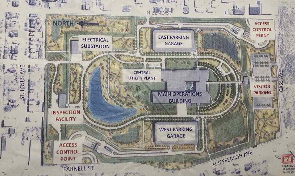
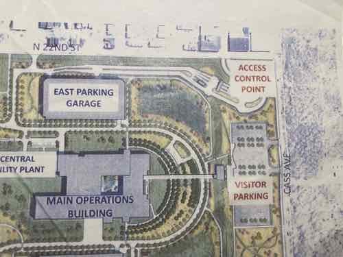
Photography & video were not allowed, but we were given a site plan for the actual design. To my knowledge this is the first site plan the public has seen of this project.
Site plan distributed last month, click image to see a larger version.
Finally seeing what the NGA is actually building gives my some hope that it can potentially have a positive impact on the trajectory of North St. Louis. My concern had been this becoming a big barrier, especially once the intact street grid was erased. Well, it’s still a barrier but the employees within the grounds will have opportunities to come & go relatively easily as pedestrians. Hopefully this will translate to businesses east, south, and west of the site.
I was also concerned about a line of cars on Jefferson Ave to enter the site.
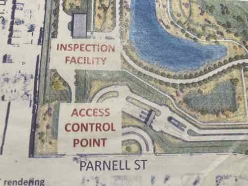
There will be two “Access control points” for those driving to work — one in the NW & SE corners of the site. Each has a curved drive to give cars room to queue up without blocking through traffic on Parnell or 22nd. This design also means vehicles can’t get a good straight run at trying to crash through the gate. All cars entering the facility are examined, especially for explosives.
The inspection facility in the NW corner will allow trucks with deliveries to unload and leave out the alley on the north. Items will be inspected before being loaded onto a secure truck for delivery to the main building.
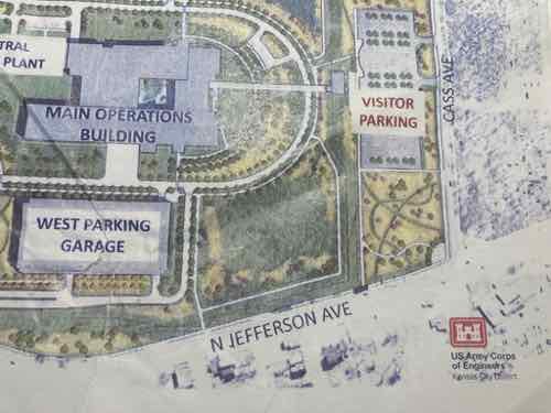
You can see a sidewalk out to Jefferson. The SW corner of the site is the intersection of Jefferson & Cass avenues. The security fencing will be set way back from Cass to allow a corner park/plaza space and visitor parking. A park that’s not behind a security fence? They’ll allow visitors?
A visitor’s center will be adjacent to the visitor parking. This center is where guests will go through security. Apparently the main building is compartmentalized such that visitors can be allowed in part without risking security in the remainder. It will have an outdoor courtyard in the center of the building.
The SE corner of the site (22nd & Cass) is the other access control point — accessed via 22nd Street, not Cass Ave. Along 22nd Street is where I hope to see businesses in the existing buildings, or maybe urban new construction. Perhaps places workers see driving in/out so they decide to walk to them at lunch.
I think 22nd & Cass will likely become a signalized intersection, possibly another at the other access point. I use the #32 bus along Cass Ave at times so I’m curious about the nearest bus stop to Jefferson — right now the westbound bus stop is before 22nd Street, so a long distance from Jefferson. No bus stops are shown on the site plan. Across Cass Ave to the south is the mostly vacant former Pruitt-Igoe site. How this gets developed will determine the long-term success of the area. I hope we don’t get a free-standing Starbucks with or without a drive-thru. A coffeehouse on the ground floor of a multi-story building on the SE corner of Cass & Jefferson would be great.
Knowing NGA employees can get in/out of the site pretty easy as a pedestrian is encouraging. The construction will be finished in 2025, the NGA expects to relocate to this new facility in 2026.
In the past you’d see multiple buildings on a single lot. Usually this was house and outhouse, stable, or garage. Large fancy homes might have servant quarters over the stable/garage — such was the case at the Campbell House. In more modest neighborhoods you might see two houses or a house and a storefront. A longtime friend owns a property that has a brick front house with full basement and a smaller frame house with a crawl space. This was not uncommon a century ago. People would build a small house at the rear of the lot and then later build a bigger/nicer house at the front.
What’s unusual about my friend’s property is the 896 sq ft brick house with basement was built first, in 1927. Then in 1936 a 440 sq ft frame house with crawl space underneath was built. My assumption is some combination of increased population and the Great Depression is why the smaller frame house was built later. Either the owner rented out the new frame house to supplement their income, or the owner moved to the frame house so they could rent the bigger brick house and avoid foreclosure. I like that the big house is less than 900 square feet. I looked up the address in the Post-Dispatch archives, the husband died in December 1934. So his widow likely added the small house for different financial reasons than I originally thought.
My friend has lived in each of the two houses at different times, both are rented now.
An accessory dwelling unit (ADU) is a legal and regulatory term for a secondary house or apartment that shares the building lot of a larger, primary home. The unit cannot be bought or sold separately, but they are often used to provide additional income through rent or to house a family member. For example, an elderly parent could live in a small unit and avoid having to move to an assisted living facility.
An accessory dwelling unit (ADU) is an additional residential building that occupies the same lot as a primary residence.
Examples of an ADU could be a guest house or a detached garage with a rented apartment above.
The establishment and use of an ADU will fall under different zoning rules and regulations depending on where you live.
An ADU can provide additional income in the form of rent.
An ADU costs money to build and upkeep and will increase monthly utility bills.
The ADU is also known as an in-law or mother-in-law unit, secondary dwelling unit, granny flat, or carriage house. An ADU usually has its own kitchen, living area, and separate entrance. An ADU may be attached to a house or garage, or it can be built as a stand-alone unit, but it generally will make use of the water and energy connections of the primary house.
Two structures on a single lot is different than the once-common two-family building, one unit over another on the same lot. The 1924 two-family I bought back in 1924 was like this, very typical for a rapidly growing St. Louis. There were also four & six unit variations.
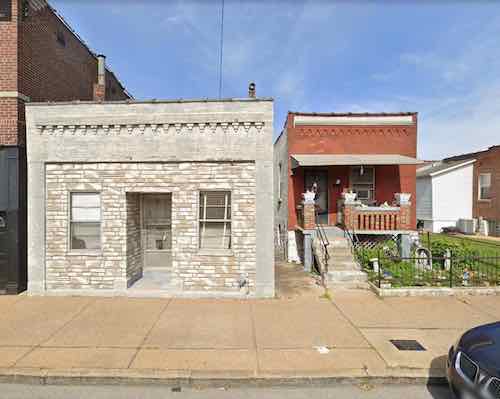
The gray building on the left was torn down late last year, it was built on the same 40 foot wide lot as they red house on the right. Image: Google Streetview
This post is about another combination you no longer see happen — the addition of a commercial building on a lot with a residence.
In 1898 two matching red brick houses were built side by side, both 844 sq ft. Each on a 40 ft x 100 ft lot.
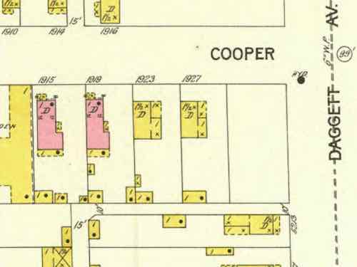
In this January 1903 map we see the two brick houses (pink) in a mostly wood frame (yellow) neighborhood Source: 1903 Sanborn Fire Insurance map, click image to view source page.
The houses were at 1915 & 1919 Cooper Street, between Daggett & Shaw avenues.
The twin houses were fourteen years old when, in 1912, one family built a 2-story brick commercial building on the same lot as the house at 1919 Cooper Street, its address was 1921 Cooper Street. A 40 foot wide lot with a house AND a commercial building!
The neighborhood was changing as more and more immigrants arrived from Italy. Multi-story masonry commercial buildings replaced many smaller wood frame houses. It’s not yet clear what business(es) initially occupied this new building, but in 1921 the family opened a funeral home.
In the late 1930s Cooper Street became Marconi Ave. In 1940 Calcaterra Funeral home moved to a new building on Daggett, just east of now Marconi Ave.
At some point between 1940 and 2021 the commercial building had the 2nd floor removed, the main floor converted to residential. It was 790 sq ft.
I don’t blame anyone for tearing down this building. Looking at the vacant spot now it’s hard to believe another building fit in the space for 109 years. See current on Google Streetview. Neighborhoods, including The Hill, continue to evolve.
Graphic from November 2020 post showing area predicted to have population loss.
The 2020 Census results results for St. Louis showed what I had predicted, the bulk of our population loss came from northside wards. This was also true in 2010 and in 2020. No reason to think 2030 won’t be more of the same. We can sit back and do nothing, or we can help manage the situation — possibly reducing some losses in future.
By mange I mean see where population is dropping more than in other areas. We can’t just write of a third of our geographic area. I propose a group comprised of experts, residents, business owners, etc to examine data and evaluate possible solutions.
Here is some of the data I’d like to see on a big map(s):
Population by age & race
Parcels of land being used (water connection) vs unused.
Parcels of land with new or substantially renovated structures vs severally deteriorated, condemned, or vacant.
Parcels of land owned by the city, out of state owners, owner-occupied, LLC, .
Historic properties, sites.
Schools, current & former.
Employers and numbers of employees
Crime
Topography
Probably other criteria as well…
Since north city is not declining uniformly we need to see which parts that are doing better than others. Is this because 0f newer housing? Access to transit? All we know at this point is some blocks are stable and occupied while others are rapidly declining. Mapped data can tell us a lot, people on the ground familiar with their area can confirm or dispute what the data tells us. Get everyone on the same page, then reassess every few years and make adjustments as circumstances change for better or worse.
What we all need to accept is that it’s very unlikely these neighborhoods will see a major population growth. Ever. Thus some land can be returned to nature, used for agriculture, etc. The maps will show us the least populated areas with the worst housing stock — contrasted with pockets of denser areas with housing unlikely to be abandoned this decade. I’m not talking about large areas the size of Pruitt-Igoe, NGA-West, or Fairgrounds Park. It might be possible that smaller nature areas could be linked together by a trail system. A few great vacant school buildings not reused for residential might get filled with hydroponics to grow produce.
The major corridors like MLK, Page, Natural Bridge, Kingshighway, Grand, etc should remain. Many connecting streets would also remain. However, it’s possible in some areas we might be able to justify removing unoccupied streets and alleys. As St. Louis begins to look at replacing lead water supply lines those areas that’ll benefit most from the infrastructure investment should get priority over areas that can be back to nature by 2030. Old water & sewer lines might get abandoned completely in isolated areas.
The goal isn’t to cut off services to existing residents, but to use resources to strengthen and grow the existing strong pockets. On a block with say only one resident we can wait until that person moves or dies of old age. The children of longtime residents aren’t really interested in moving into the house their relative refused to leave. Conversely, a nice block with one newly-abandoned house needs help to make sure that one house gets maintenance and reoccupied as soon as possible. Quickly reoccupying a vacant building helps prevent others on the block from also being abandoned.
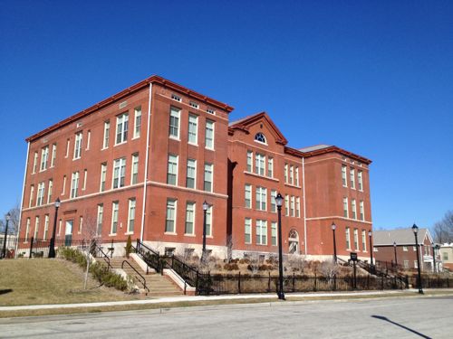
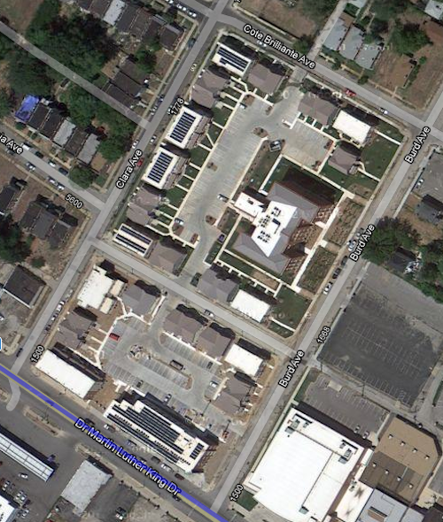
An example of a strong pocket would be MLK & Burd Ave. You’ve the Friendly Temple church and Arlington Grove housing (new housing around a renovated school that’s also housing). Substantial investment has been made, and this is home to many. We can reinforce the positives and look to expand upon that a block at a time.
Former Arlington School has been residential since 2013Aerial after construction completed. Image: Google Maps
Just north of this pocket is a largely vacant area, part of the Wells-Goodfellow neighborhood that has gotten attention for mass demolitions. Other bright spots throughout north St. Louis include numerous tree-lined streets with well-maintained houses — it’s just hard for everyone to see & appreciate the them with so much decay. Whenever I see people wanting to raze vacant “problem” buildings I do get upset, because tearing down buildings in a random manner doesn’t improve neighborhoods for the long-term. It simply removes the current problem while likely speeding up others being abandoned as neighboring owners/residents die or move. By designating different areas for bright spot village and others as moving back toward nature we can reduce fights over razing vs preservation. I can even imagine a decent house in an area set to become nature/agriculture –it might be kept as basically a farmhouse. It wouldn’t necessarily be razed, just reimagined.
Along the way we can reevaluate I-70, an old interstate that winds its way through north city. Can we minimize this as a separating barrier in spots? Can we create areas for interstate drivers to pull off and get a bite to eat while their battery electric vehicle (BEV) charges?
One spot I see as the center of a future village is the intersection of Grand & North Florissant. That’s in part of 2 current neighborhoods, with a 3rd very close. It should be the very center of a thriving area.Why here? The intersection of two corridors should be treated as special. Both Grand and North Florissant are angled toward each other, so a person living or working here can pick either corridor to travel south — southeast on North Florissant or Southwest on Grand. Thanks to the odd street grid they have easy direct access to different parts of the city. Going northwest on North Florissant will eventually get them into St. Louis County.
By 2050 I see north St. Louis as being dotted with nice little villages, with nature in between. Primary corridors will be a line of density with restaurants, retail, offices, and multi-family housing. Rail &/or rubber tire public transit will connect these villages to each other and the larger city & region. I see walking & biking within and between villages. I see jobs growing produce outside and indoors, more jobs along the corridors. I see trees — thousands of them providing some relief from increased temperatures. The major corridors will be tree-lined, many new nature areas will become forests. I see all races, proportional to the mix in the population. Some villages, like The Ville, are predominantly black (75%, not 100%) with strong black-owned businesses. Again I’m talking 30 years, not 3.
What I don’t see are big surface parking lots for big box chain stores. I also don’t see blocks and blocks of obvious vacant residential buildings/lots.
St. Louis should use some of the money from the NFL to kick start the planning process to examine north St. Louis as I’ve described — taking stock and what we have (and don’t have) and then collectively finding solutions to change the trajectory. In the process others could come up with better ideas.
It has now been a decade since a 33-year mistake was corrected. During the 1960s & 1970s removing a street to create a “pedestrian mall” was a magic bullet tried by cities coast to coast. Almost fall failed.
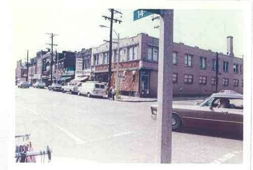
In the early 1970s North 14th Street merchants began looking for solutions to a decline in sales as residents of the surrounding near north neighborhood left for better housing elsewhere.
From a May 1972 Washington University graduate thesis
The solution, they thought, was to mall 14th Street. Some buildings behind the street were razed to create large surface parking lots, so former residents could drive back to their old neighborhood to shop at chains like JC Penny & Woolworth’s and local businesses like Sobel’s Furniture.
Open air and enclosed malls were attracting more and more customers so remaking a decades-old neighborhood shopping district to emulate suburban malls would attract customers. Well, that was the theory that led to hundreds of streets nationwide being malled.
More like mauled.
The new 2-block long mall opened on March 2, 1977. Two blocks of North 14th Street were closed to vehicles, from Warren Street on the south to St. Louis Ave on the north. The one cross street, Montgomery Street, was also closed. See current map.
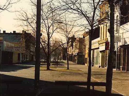
By the time I first saw it in the Fall of 1990 very few businesses remained.
Looking south on 14th, Spring 1991
By the Spring of 1991 I was living in the Murphy-Blair neighborhood, the local group was working to rename it Old North St. Louis. The neighborhood located just north of downtown St. Louis was a separate village 1816-1841, when it was annexed by a growing St. Louis.
Two business that were were just beyond the mall were Marx Hardware (Est 1875) and Crown Candy Kitchen (Est 1913), both are still in business.
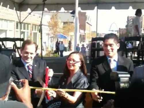
I left the neighborhood in August 1994, but others finally figured out how to put together a project to both renovate the buildings that remained and put back the street. I applaud all involved for their perseverance.
The ribbon cutting was held on July 29, 2010
After the ribbon cutting & celebration traffic didn’t immediately begin driving up & down 14th Street. The new streetlights were delayed, so the city’s Streets Dept wouldn’t let cars use the new street. Within a few months the lights and a few other punch list items were completed.
The former Woolworth’s at 14th & Montgomery in 2010.
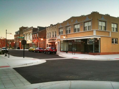
In the decade since the reopening new occupants of the storefronts have changed, retail is a struggle everywhere. The spaces aren’t empty, which is important. The street trees have matured nicely.
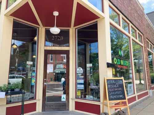
Old North Provisions diagonally across from Crown Candy Kitchen in August. Click image to see their website in a new tab.
Some say the mall helped keep these buildings from being destroyed, but I think had the mall not been built the street might have been slowly brought back one business at a time, like others in St. Louis.
Today’s post is about HOPE VI projects. You may have heard that term before, but if you’re unfamiliar here’s an introduction:
HOPE VI is a program of the United States Department of Housing and Urban Development. It is intended to revitalize the worst public housing projects in the United States into mixed-income developments. Its philosophy is largely based on New Urbanism and the concept of defensible space.
The program began in 1992, with formal recognition by law in 1998. As of 2005, the program had distributed $5.8 billion through 446 federal block grants to cities for the developments, with the highest individual grant being $67.7 million, awarded to Arverne/Edgemere Houses in New York City.
HOPE VI has included a variety of grant programs including: Revitalization, Demolition, Main Street, and Planning grant programs. As of June 1, 2010 there have been 254 HOPE VI Revitalization grants awarded to 132 housing authorities since 1993 – totaling more than $6.1 billion. (Wikipedia)
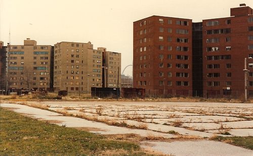
The short answer is HOPE VI was the program used to raze & replace distressed high-rise public housing with low-rise mixed-income private housing. With the notable exception of Pruitt-Igoe, all of St. Louis’ high-rise public housing was replaced with low-rise housing — three using the HOPE VI program. Pruitt-Igoe was famously imploded two decades before the start of the HOPE VI program.
From a May 2004 research report after a decade of HOPE VI:
Launched in 1992, the $5 billion HOPE VI program represents a dramatic turnaround in public housing policy and one of the most ambitious urban redevelopment efforts in the nation’s history. It replaces severely distressed public housing projects, occupied exclusively by poor families, with redesigned mixed-income housing and provides housing vouchers to enable some of the original residents to rent apartments in the private market. And it has helped transform the Department of Housing and Urban Development’s (HUD) approach to housing assistance for the poor. Thisreport provides a comprehensive summary of existing research on the HOPE VI program. Its central purpose is to help inform the ongoing debate about the program’s achievements and impacts, and to highlight the lessons it offers for continuing reforms in public housing policy.
HOPE VI grew out of the work of the National Commission on Severely Distressed Public Housing, which was established by Congress in 1989. Congress charged the Commission with identifying “severely distressed” public housing developments, assessing strategies to improve conditions at these developments, and preparing a national action plan for dealing with the problem. Based on its investigation, the Commission concluded that roughly 86,000 of the 1.3 million public housing units nationwide qualified as severely distressed and that a new and comprehensive approach would be required to address the range of problems existing at these developments.
In response to these findings, Congress enacted the HOPE VI program, which combined grants for physical revitalization with funding for management improvements and supportive services to promote resident self-sufficiency. Initially, housing authorities were allowed to propose plans covering up to 500 units with grant awards of up to $50 million. (Introduction to an Urban Institute report)
I should clarify the HOPE VI program isn’t limited to only remaking high-rise public housing, but that is the type of distressed public housing we had in St. Louis. Other cities, like Chicago, also used it to replace high-rise projects. Cabrini-Green, for example.
Let’s take a look at the four St. Louis high-rise public housing projects that were replaced with low-rise housing built on a more traditional street grid.
Darst-Webbe
The Darst-Webbe towers on the near south side circa 1990-91, razed
This was officially known as the J.M. Darst Apartments and the A.M. Webbe Apartments. The Darst apts., opened in October 1956, occupied 14.75 acres bounded by Lafayette, Hickory, Tucker (12th) & 14th. The four 9-story buildings contained 645 units. The Webbe apts. opened in May 1961 between the Darst apts. and Chouteau. It had a mix of buildings on 12.27 acres: two 9-story, one 12-story, and one 8-story. These four buildings had 580 units. The combined Darst-Webbe then had 1225 apartment units on 27.02 acres.
This was the first high-rise public housing project in St. Louis to be razed and rebuilt under the HOPE VI program. In its place is a mix of apartments and privately-owned single-family homes. On the south is King Louie Square apartments, with 152 1-4 bedroom units. In the middle of the redevelopment site is the single-family homes, called La Saison. Habitat for Humanity is building new homes here on the few vacant lots remaining. The north part of the original site contains more apartments, called Les Chateaux — with 40 1-2 bedroom units.
House at La Saison on Tucker near Park Ave, the north edge of King Louie Square can be seen on the left. Photo December 27, 2013.Looking north on 14th street toward LaSalle. The buildings on the left are rental townhouses in the redevelopment area, just not sure if they have a name. Photo: November 7, 2018.
In 1995 HUD gave the St. Louis Housing Authority a grant of $46.7 million to redevelop Darst-Webbe. Defunct developer Pyramid Construction is responsible for the pretentious names.
Vaughn
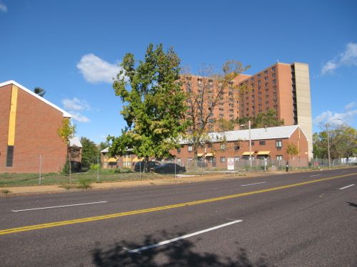
This was two projects, both called G.L. Vaughn Apartments. The first, opened in June 1957, was bounded by Cass, O’Fallon, 18th, and 20th. It had four 9-story towers on 16.67 acres — with 647 units. The second opened at the NE corner of 20th & O’Fallon in September 1963. Basically this was just an expansion of the project that opened six years earlier, it had one 8-story building on 2.05 acres, 112 units.
The last Vaughn tower being razed in October 2006.New housing, called Murphy Park, had already been built where the other four towers had been razed.The Murphy Park senior building and management offices.Looking south on Vinson Street from a new park on Biddle Street.
Vaughn was completed, to the best of my knowledge without the use of a HUD HOPE VI grant, but like others it got state low income tax credits.
The partnership event highlighted Phase III of Murphy Park. Its 126 units will bring to 413 the total number of rental dwellings built in the neighborhood that once was the site of the notorious George L. Vaughn public housing high-rises. One third of the completed project will be market rate apartments, with the balance constructed as tax credit units – with just more than half available for public housing-eligible families as part of the replacement of the former public housing complex. Units range from two to six bedrooms and include disability-accessible garden apartments. Each apartment features full size appliances including washer and dryer, refrigerator, stove and dishwasher. McCormack Baron Management Services, the management agent, reports that Phases I and II (completed in 1997 and 2000) have high-90 percent occupancy. Phase III units will be available in March 2003. (HUD)
As the above indicates, this was a McCormack Baron development.
Blumeyer
This was officially the A.A. Blumeyer Apartments. It opened in October 1968, bounded by Compton, Delmar, Grand & Page. It had two 14-story buildings for “elderly”, three 15-story buildings, and forty-two 2-story buildings. There was a total of 1,152 units on 33.90 acres.
Low-rise & high-rise buildings at Blumeyer before being razed. Photo October 2006Blumeyer Elderly Apartments on Page, January 2007
This was replaced by the Renaissance Place at Grand apartments and the offices of the St. Louis Housing Authority. To the north, across Dr. Martin Luther King Blvd, Senior Living at Renaissance Place was built on land not part of Blumeyer. Additionally, the North Sarah Apartments were built on…North Sarah… to provide additional units.
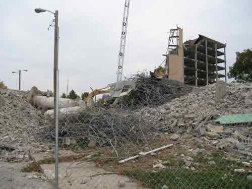
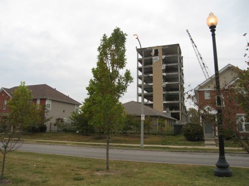
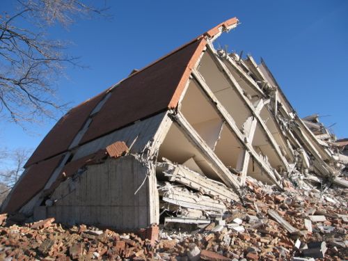
New apartment within a grid of new streets in February 2013, the last Blumeyer tower in the background — demolition on it began in the fall of 2014
The $35 million dollar HUD grant was issued in 2001. Like Vaughn, this was a McCormack Baron project.
Cochran
Officially the J.J. Cochran Garden Apartments. Completed in April 1953, it was St. Louis’ first high-rise public housing project — more than two years before Pruitt Homes and three years before Igoe Apartments. The 18.03 acre site contained four 12-story, two 7-story, and six 6-story towers — containing 703 units. It was built to clear out old tenemts businesses on the north edge of the business district didn’t like. Then Cochran became a problem, but tenants pushed for the ability to self manage — and won!
Cochran Gardens was a public housing complex on the near north side of downtown St. Louis, Missouri. Construction was completed in 1953. The complex was occupied until 2006, it was famous for its residents’ innovative form of tenant-led management. In 1976, Cochran Gardens became one of the first U.S. housing projects to have tenant management. Built by the same firm, Leinweber, Yamasaki & Hellmuth, as the infamous Pruitt–Igoe complex, Cochran Gardens was more successful than its ill-fated sister project. In the mid 1970s, Bertha Gilkey and a group of friends successfully led a community driven rehabilitation effort; in 1976 she won a property management contract from the city. Independent management improved Cochran Gardens and created small business jobs in the neighborhood. President George H. W. Bush visited the site in 1991, commending tenant management and Bertha Gilkey. However, in 1998 city authorities took over Cochran Gardens, citing tax mismanagement by the tenant association. The buildings rapidly deteriorated, by 1999 vacancy rate increased from under 10% to one-third. (Wikipedia)
I photographed the area in May 2007 as towers still existed and as new construction was going up, streets going in.
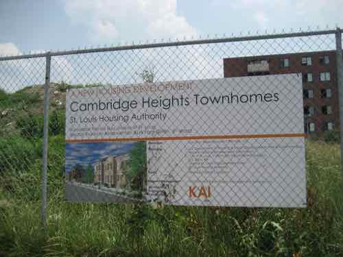
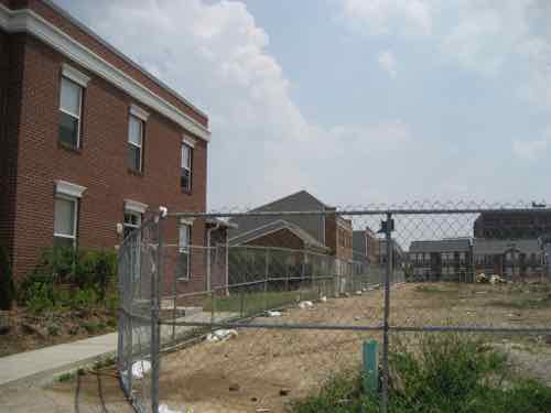
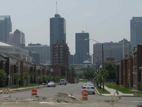
The last high-rise tower from the Cochran Gardens project was razed in 2011. This is 9th & O’Fallon on May 29, 2007.At 7th & O’Fallon you can just see the historic Neighborhood Gardens project on the left, new Cambridge Heights apartments on the right. In the background is an old Cochran tower about to be demolished. Note traffic signals were still in place along 7th street.From 9th street we can see the other side of the Cochran tower before demolition, and new townhouses facing 8th street. The building on the horizon is on 7th, was part of McGuire Moving & Storage.Project signLooking to the left we see more new townhouses between 8th & 9thLooking south on 8th Street from Dickson Street. Dickson Street didn’t exist between 7th and 9th prior to Cochran, but the street name was used east of 7th. Eighth street was removed for Cochran, it was mostly rebuilt.
This project was completed by an LLC that includes architect Michael Kennedy of KAI (previously known as Kennedy Associates, Inc). McCormack Baron was management from the very beginning, until February of this year. In a future post I’ll go into more detail on Cochran Gardens & Cambridge Heights.
Summary
These four areas are all significantly better because of each redevelopment. The New Urbanist influence has been a key factor in their success. The buildings in all four orient toward the public street. HOPE VI projects have valid criticism, largely the reduction in the number of public housing units for the very low income. The other is the charge of gentrification, a valid claim in other cities but not in St. Louis. More on that in the future.
AARP Livibility Index
The Livability Index scores neighborhoods and communities across the U.S. for the services and amenities that impact your life the most
Built St. Louis
historic architecture of St. Louis, Missouri – mourning the losses, celebrating the survivors.
Geo St. Louis
a guide to geospatial data about the City of St. Louis