Home » Downtown » Recent Articles:

Deplorable Surface Parking Lot At 1601 Locust Cited, Fined

Yesterday I posted about a privately-owned surface parking lot that has used 75o square feet of the public right-of-way for years, see Deutsch Family Has Profited From Public Right-Of-Way For Nearly Two Decades. Today’s post is about another privately-owned surface parking lot five blocks West.

The lot at 1601 Locust St. is next door to my condo building. When the original condos were sold, and when I bought a couple of years later, in 2007, the lot was under control/ownership of Loftworks  — the developer of Printer’s Lofts. The plan was to construct a new building and connect to the existing two. However, the economy fell out and Loftworks lost control of the lot.

Paving issues, from May 2013
Another from June 13, 2014
From April 29, 2016. The car in the background has been booted for non=payment
Also from April 29, 2016 -- a close up at one of the pothole ponds
Also from April 29, 2016 — a close up at one of the pothole ponds

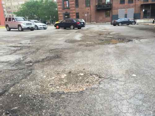
I first complained about the condition to the Citizen’s Service Bureau in 2013, have done so twice since then. Each time the complaint has been marked resolved. I’m told by 5th Ward Neighborhood Improvement Specialist Sharie Taylor that the owner has been sent multiple violation letters. In an email to me she wrote:

[The inspector]  currently has this property under notice and will be doing a reinspection in the near future. If the owner has still not complied, then they will receive fines for each violation. Unfortunately, beyond that, the city can’t do much to force the owners to fix the lot.

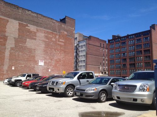
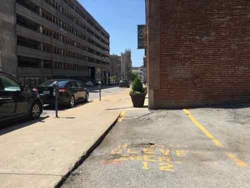
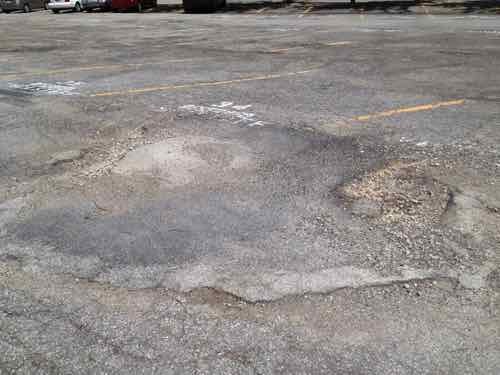
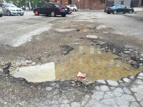
I asked about court, and she confirmed that’s the next step if fines aren’t paid. My motivation, however, is maintenance & upgrades. Upgrades, not just new asphalt? Yes, because two other problems exist. The one disabled spot is not identifiable:

Faded wheelchair symbol in 2013, lacks vertical sign

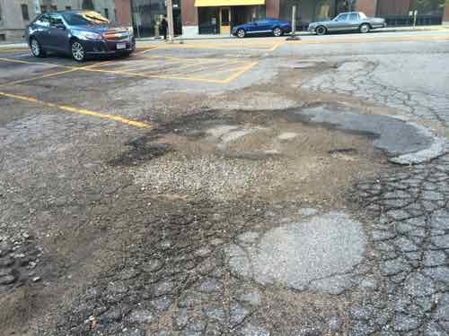
What remained in 2013 is no longer visible. The other issue is people parking on the 16th Street sidewalk — easily prevented by wheel stops.

September 2013
September 2013
June 2014
June 2014
The worst I've ever seen, from April 4, 2016
The worst I’ve ever seen, from April 4, 2016
Also from April 4th
Also from April 4th
April 27th
April 27th
April 28th
April 28th

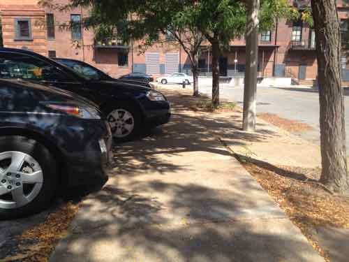
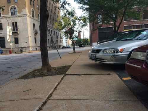
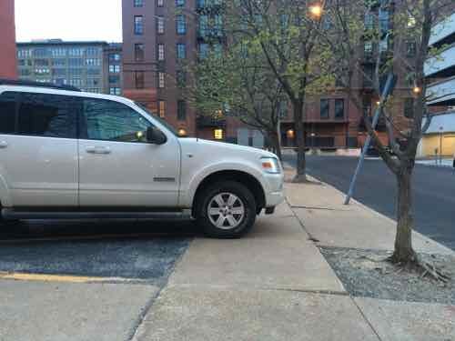
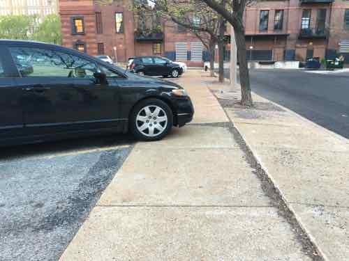
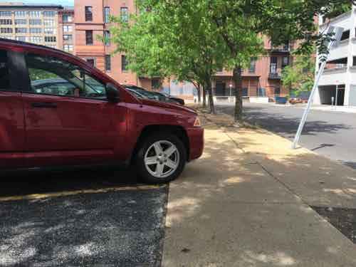
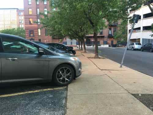
Again, wheel stops along 16th Street would prevent cars from pulling so far forward they overhang the sidewalk or have tires fully on the sidewalk.

Unsatisfied with the city’s pace, I faxed the owner, Kathleen Bonan, manager of Saylor Properties #1, LLC, which has the same address as the law form Bonan, Bonan, & Rowland: 116 E. Market St. McLeansboro IL  Faxed? Yes, no website or email could be found for their law firm.

There are a lot of Bonan’s in McLeansboro, like Hunt:

One of southern Illinois’ largest contributors to Gov. Rod Blagojevich’s campaign fund denied pay-to-play politics were a factor in his appointment to the state Department of Employment Security. 

Since 2002, Hunt Bonan, owner of Market Street Bancshares, the holding company for Peoples National Bank, made personal contributions to Friends of Blagojevich totaling $20,375, according to the State Board of Elections. Contributions listed as provided by Market Street Bancshares total $124,225. 

Bonan is one of six residents from either Mount Vernon or McLeansboro to receive appointments during the governor’s six years in office. (State Journal-Register)

He and his brother bill are part of People’s National Bank.

On August 8, 1988, shareholders Bill Bonan, an attorney, and his brother, Hunt Bonan, formed a bank holding company for the purpose of acquiring 100% of the stock of Peoples National Bank. The holding company was named Market Street Bancshares, Inc. as a reference to the location of their family law firm, Bonan & Bonan, on Market Street in McLeansboro. At the time the holding company was formed, Peoples National Bank assets totaled $50 million. The original Board of Directors of the holding company was comprised of:

Bill Bonan, Chairman of the Board, Secretary and Treasurer
Hunt Bonan, President
Frank Bonan, Attorney at Law – Father of Bill and Hunt Bonan
Duane Baumann
Steven Epperson
Richard Rubenacker
Bob Prince
Don York

I don’t see financial hardship being a reason for the condition of the lot.

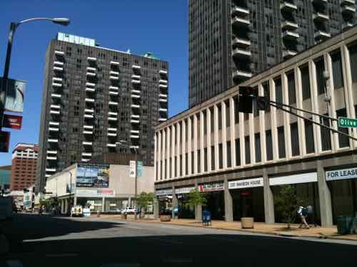
Later this week I plan to stop by the offices of the operator, SP+/Central Parking, located at 720 Olive, Ste 1650. Between them and the owners this mess needs to get addressed!

— Steve Patterson


Deutsch Family Has Profited From Public Right-Of-Way For Nearly Two Decades

Some take big all at once, but others take just a little over a long period — the latter can continue with few noticing and nobody able to stop it. Seven years ago I posted about theft of public property, see Stealing a Sidewalk (images since lost). Since then nothing has changed.

Much of city block 823 bounded by 11th, Locust, Tucker, & St. Charles, is surface parking. Miss Hullings Cafeteria was located on the NW corner of 11th & Locust for decades.

In the late 1990s, Larry Deutsch was finally allowed to raze the historic 4-story building at 1101 Locust St. that housed Miss Hullings Cafeteria for decades. After the demolition crew left, new sidewalks were poured and the lot was covered in asphalt for surface parking. That’s when the line dividing private from public property was moved more than 3 feet. Legally the lot is 121 feet x 102 feet 6 inches. But by narrowing the public sidewalk, they made their lot 124.33′ x 105.83′ — a gain of 6%! This is roughly 750 square feet of public space that has been used privately for years.

This allowed them to have 5 additional parking spaces. The current daily rate is often $10, but let’s say $5/day. With about 300 revenue days a year, that’s $7,500 in additional revenue per year. Over 18 years the total estimate is $135,000. Serious money made by taking from the public right-of-way.

Looking West we can see how the sidewalk doesn't relate to the building line
Looking West we can see how the sidewalk doesn’t relate to the building line next door.
It's a difference of 3 feet 4 inches
It’s a difference of 3 feet 4 inches


Looking South along 11th you see the difference. The sidewalk in the foreground is owned by someone else, but it narrows at Deutsch's lot across the alley
Looking South along 11th you see the difference. The sidewalk in the foreground is owned by someone else, but it narrows at Deutsch’s lot across the alley

It’s very obvious in person and pictures. You might be thinking the legal property lines are different than the adjacent properties to the North & West. Typically the Public Right-Of-Way (PROW) doesn’t narrow suddenly by more than 3 feet. I know from a Sanborn Fire Insurance map the line was straight in February 1909 (see for yourself).

As we know, the city has been vacating streets & alleys for decades — perhaps this was changed when nobody was looking? So last week I went down to city hall to look at the official plat records.

Photo of the plat of city block 823
Photocopy of the page shows the adjacent property aligns -- the PROW isn't 3+ feet narrower
Photocopy of the page shows the adjacent property aligns — the PROW isn’t 3+ feet narrower

The owner is Double Delta Arizona LLC. This Missouri LLC was created in July 2009 by Larry Deutsch, 14 Wydown Terrace in Clayton, MO. It is to register a foreign (non-Missouri) entity of the same name, but located in Arizona and created on October 27, 1993.  A search of the Arizona Corporation Commission confirms that Double Delta Arizona LLC was formed on that date. The current agent is Michael Benjamin Deutsch, 33 Oakwood Hills, Chandler AZ. Maricopa County Assessor’s records show the owners as Michael & Jill Deutsch.   Double Delta Arizona LLC is a property management company located at 2130 West Chandler Boulevard, Chandler, AZ. Chandler is a suburb of Phoenix.

Back in our city hall, I stopped by the Recorder of Deeds office to look up public records on 1101 Locust. The most recent was from April 2006, a Quit Claim Deed (Wikipedia) to transfer ownership.

Signatures transferring ownership on page 2. Click image to view 2-page PDF on Scribd

The 1101 Locust Street Corporation was created in June 1993, dissolved in November 2007.  What I don’t know is if the PROW was reduced deliberately or accidentally.

Here’s what I’d like to see happen:

  1. The Deutsch family acknowledge they’ve been using part of the PROW for years.
  2. The Deutsch family pay the city for the cost to a) remove asphalt and pour additional concrete or b) pour new sidewalks up to the legal property line.
  3. The Deutsch family update the surface parking lot to the city’s current parking lot standards. including physical separation (fencing, landscaping) between private & public property.
  4. The city remove/reduce the existing curb cuts, requiring access via the alley on the North side of the property.

Some of you might be thinking this is not big deal — a sidewalk still exists. Yes and no. At the drives there is basically zero ADA-compliant sidewalk width. Zero.  This is a pain for many besides myself — families with a baby stroller, for example.

This is yet another example of the awful pedestrian experience in St. Louis. The problem has been identified, now it should be corrected!

— Steve Patterson


Mansion House Center 50th Anniversary

During the Urban Renewal era St. Louis leveled much of downtown — chasing away residents, businesses, shoppers, workers, etc. By the mid-1960s blocks and blocks of once-vibrant land began to get new structures. In October 1965 the top piece of the Arch was set into place. A couple of weeks before Busch Stadium II opened, a new residential project opened: Mansion House Center.

The Mansion House center faces 4th Street, 2011 photo
A plaque next to the center fountain lists those involved and the date -- April 29, 1966. Photo from April 2011
A plaque next to the center fountain lists those involved and the date — April 29, 1966. Photo from April 2011

It was everything good & bad about 1960s modernism. On the plus side it had clean lines and quality materials. On the negative, it rejected the public sidewalk & street grid. Cars stored in the massive, but confusing, garage faced the new Arch. One level up from the public sidewalk, a private promenade level sought to remove residents from the street.

As I’ve said before, the three towers are good. It’s the low-rose platform base & garage that need to be reworked. Olive & Locust need to be reopened. The East face needs to be connected to a future boulevard. The center is divided among multiple owners, so the likelihood of a project to undo the anti-city aspects is slim.

— Steve Patterson


5th Anniversary of St. Louis’ Downtown Bicycle Station

April 28, 2016 Bicycling, Downtown, Featured, History/Preservation Comments Off on 5th Anniversary of St. Louis’ Downtown Bicycle Station

Five years ago today the ribbon was cut on a new concept in St. Louis — a bike station. A place where a bike commuter can shower and change clothes before going into his/her office.

The ribbon was cut just after 10am on April 28, 2011
Then we got to go inside
Secure area for storing your bike during the day
Lockers and showers are in the back,

The Downtown Bicycle Station is a project of Trailnet, which is located upstairs in the same building.

The Downtown Bicycle Station offers secure 20-hour access and features over 120 bike racks, showers and locker rooms, and is ideal for bicyclists commuting to work or looking to exercise on their lunch break.

Memberships are $20/month or $150/year.  Corporate memberships are $1,000/year for 10 users. A day membership is $5 — enter via Big Shark Bikes next door (limited to their hours).

Bike facilities have increased in these last five years, the data center at 210 N. Tucker includes a secure bike parking area  inside the building. 
Bike facilities have increased in these last five years, the data center at 210 N. Tucker includes a secure bike parking area  inside the building.

Hopefully more and more young people will be attracted to high tech and other jobs downtown — walking, biking or riding public transit to/from work.

— Steve Patterson


Olive & Tucker Designed for Pedestrian-Vehicle Conflict

The intersection of two major downtown streets — Olive St & Tucker Blvd — is poorly designed for pedestrians. The are a number of problems, but this post is about poor communication to pedestrians that puts them in harms way. Specifically, vehicles that get a left-turn arrow from Tucker to Olive are on a collision course with pedestrians that don’t realize cars will be turning left into their path.

Vehicles traveling Northbound & Southbound on Tucker each get a dedicated left-turn lane onto Olive, Westbound & Eastbound. respectively.  Each gets a left arrow, so drivers assume they have the right-of-way. “What’s the problem?” you ask. Pedestrians can also think,due to a lack of pedestrian signals, they have the right-of-way.

  1. At the start of the cycle SB vehicles on Tucker get a green light, left onto EB Olive get an arrow.
  2. After a bit the arrow goes away and NB traffic gets a green.
  3. Later the SB traffic gets a red and those going NB get a left arrow onto WB Olive.

Pedestrians & vehicles can’t both have the right to be in the same place at the same time!

You might be thinking “pedestrians should just look at the vehicle signals to know when it’s OK to cross Olive.” For SB pedestrians on the East side of Tucker & NB pedestrians on the West side of Tucker the vehicle signals don’t indicate vehicles have a left-turn arrow.

SB on the East side of Tucker we can't see the signal on the right -- it's turned toward cars in the left-turn lane.
SB on the East side of Tucker we can’t see the signal on the right — it’s turned toward cars in the left-turn lane.
NB on the West side of Tucker we see a woman crossing with the green. What you can't see ifs the left-turn lane has an an arrow to turn right in her path!
NB on the West side of Tucker we see a woman crossing with the green. What you can’t see ifs the left-turn lane has an an arrow to turn right in her path!

So the first should be a relatively easy to get to achieve minimally acceptable communications — turn the signal head so pedestrians can see the green & left arrow. But the second isn’t as simple.

If possible, the bare minimum would be to change the signal head so it includes an arrow. The problem with this is the arrow might suddenly appear as a person is halfway across Olive. This really needs a pedestrian signal with a countdown timer. Another option is to redo the signal configuration — allow both left turns to happen simultaneously — then give them a red while NB/SB vehicles get a green.

Ok, so one intersection — fix it and move on, right? If the woman in blue in the 2nd image keeps waking North she’ll encounter the same conflict one block up at Locust St!

As at Olive, the signal is green but pedestrians walking North don''t know a left-turn arrow is going to send vehicles into their path.
As at Olive, the signal is green but pedestrians walking North don”t know a left-turn arrow is going to send vehicles into their path.

These are just a few examples of the dangers designed into our auto-centric system. I’ve been through these intersections many times, but had never noticed the conflict — because I’m familiar with the vehicle flow. A downtown visitor, however, might not be confused, or worse, became a pedestrian death statistic. If a pedestrian is hit by a left-turning car in these examples it’s no “accident” — it’s by design! Sadly, these conflicts have likely existed for years — perhaps even decades!

Every intersection in the city/region needs to be critically evaluated to catch conflict by design. Prioritize then and then set about correcting them. I pointed out the conflicts at Olive to St. Louis’ new Bike/Pedestrian Coordinator, Jamie Wilson, last week as we walked/rolled to lunch.

I’ve volunteered to:

  • Start a custom Google map where I can catalog problems I encounter.
  • Go out with him and other, upon request, to demonstrate the problems with out pedestrian infrastructure

Below is time-lapse video looking South and then North

— Steve Patterson


Advertisement


[custom-facebook-feed]

Archives

Categories

Advertisement


Subscribe