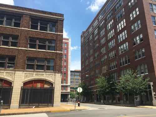
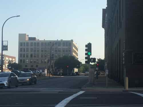
For years now I’ve tried to end the week on a positive note, but it’s becoming increasingly difficult for me to be optimistic about St. Louis’ future. Today is the final vote on BB64 to give public land to a developer, cutting off others from Washington Ave. The following image illustrates the potential problem.
Looking North toward Washington Ave from the WW corner of 17th & Locust St.
Behind me is the massive Butler Brothers Warehouse, at left is 1701 Locust — both vacant and in need of rehab. At right is one of our two buildings at Printers Lofts, the 5,500 sq ft first floor is currently vacant and for sale. Cutting them off from access to Washington Ave will not help.
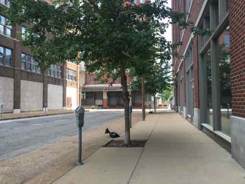
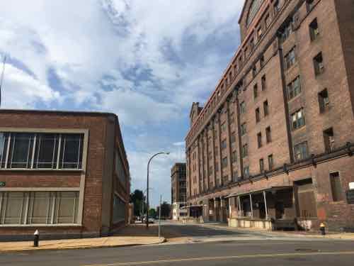
Looking North on 17th, a clear shot to Washington Ave if the old CPI dock was removed from the public right-of-wayFrom the NE corner of 17th & Locust you can see the Post Office on the South side of Market.
Voting yes on BB64 would be incredibly short-sighted sided.
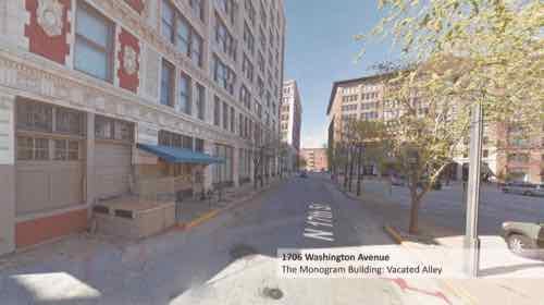
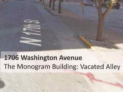
I looked through the materials — many of which are Google Street View screen captures. They couldn’t even come take photographs? One page explained a lot about the view of the developer & architects:
Google Street View looking North on 17th Street toward Washington Ave — but how it’s labeled that shows their lack of understandingA close up shows they view 17th Steet as an alley
The final vote on BB64 will likely take place tomorrow, hopefully the full board will reject it outright. Many signatures have been collected on petitions opposing the vacation of 17th St, from numerous adjacent condo projects. The Downtown Neighborhood Association has also gone on record in opposition. We want to see the Monogram/CPI building occupied, but not at our expense. The public uses 17th Street daily.
I thought I was done pointing out glaringly bad intersections for pedestrians, but on Saturday I went through one that was odd. Yesterday I returned to study. Usually when I cross Olive Street at 18th I do so on the East side of 18th. Though I’ve lived nearby for over 8 years, I can’t think of one time I crossed Olive on the West side — until Saturday afternoon.
We were headed to the St. Louis Science Center, catching MetroLink and then a MetroBus. Knowing we’d need to be on on the West side of 18th I crossed at Locust and headed South. At Olive I pressed the button for a walk signal — something I shouldn’t need to do in a pedestrian-friendly city. The traffic light turned green but the pedestrian signal remained don’t walk. We were in a hurry to catch the train so we went based on the green traffic signal. Yesterday morning I went back to try to figure out why I didn’t get a walk signal after pressing the button. What I found is this intersection is one of the most inconsistent in the city.
Each crossing point in an intersection is called a leg, typical intersections have four legs. Intersections where are four are treated consistently is a challenge, but the is among the worst — if not the worst in the city. And it’s recent work!
Looking South across Olive from the NW corner
At the NW corner of 18th & Olive I see the traffic light turn green and the pedestrian signal remain on don’t walk. I press the button at the next red and when the light turns green the pedestrian signal remains don’t walk. At the next red I press the other button marked for crossing 18th Street. This time when the light turns green the pedestrian signal gives a walk symbol. It should be noted, the pedestrian signal to cross 18th St always gives a walk sign when the traffic signal is green.
Looking South across Olive from the NW corner
Pushing a button to cross Olive but not a side street is consistent with the other intersections redone along Olive at the same time. After posting about Olive & Leffingwell in April I was told by the City’s bike/ped coordinator, Jamie Wilson, that a button was necessary to cross Olive there because vehicle traffic on Leffingwell is infrequent and they didn’t want to stop traffic on Olive to cycle through stops when there were no pedestrians or vehicles to cross. Makes sense…at Leffingwell. Leffingwell is one of the many streets where the city gave away the public right-of-way to private interests a block South of Olive. PROW that doesn’t so through sees fewer vehicles & pedestrians.
Back to 18th & Olive — 18th Street is always a busy street. Recently many MetroBus routes were moved to 18th. So switch the buttons and it’s fine? I decided to check every corner to see. So I pressed the button to cross 18th so I’d get a walk signal to cross Olive.
Looking North across Olive from the SW corner
At the SW corner I pressed the button to cross Olive. Like the NW corner, I didn’t get a walk sign. Thinking it must also be reversed like the NW corner, I pressed the button to cross 18th. Still nothing, neither button activates the walk signal for NB pedestrians wanting to cross Olive on the West side of 18th Street!
Looking North across Olive from the SE corner
I crossed 18th to the SE corner — no button is necessary — these always give the walk signal when vehicles get a green light. Interestingly, the pedestrian signal gives a walk sign when the traffic light is green regardless of the button or not. It’s possible pressing the button adds additional crossing time. I crossed to the NE corner.
Looking South across Olive from the NE corner, the automatic walk light
Southbound pedestrians don’t need to press the button to cross Olive on the East side of 18th. Same as those crossing NB. What’s different is those crossing SB get a countdown timer, those crossing NB do not.
Looking South across Olive from the NE corner, the countdown timer has started
So I have many questions for Jamie Wilson:
Why only one countdown timer?
Why do three legs automatically get a walk sign, while the forth doesn’t?
Why don’t NB pedestrians on the West side of 18th ever get a walk sign?
For the legs where pedestrians do get a walk sign, does pressing the button give additional crossing time?
Why not have all four legs automatically get a walk sign?
It should be noted this work was done prior to Mr. Wilson starting his current position. It was done either by the Board of Public Service (BPS) or the Streets Dept, not sure which. Hopefully I’ll know more soon, and the city will clean up this intersection’s bad pedestrian experience.
BB64 passed unanimously in committee, though Downtown Neighborhood Association Executive Director Jared Opsal spoke against it. Had we all known about it we would’ve packed the hearing room. Which is why the developer & Ald Davis didn’t tell us. However, my post today isn’t about BB64, it’s about the broader issue of notification about street vacations.
The fact that a bill giving away a public right-of-way (PROW) so many of us use daily could move so quickly before being noticed is shocking. I don’t want this to happen to others in the city. Your alderman might tell you of such things, but not all of us are that lucky.
What we need is a process for public notice, not unlike the one used for liquor licenses, zoning changes, etc. I think it need several components:
Posted notice at the location for at least 15-30 days in advance of first hearing
Mailed notice to property owners within 500′-1,000′ of location
The same should apply to blocking an end of a street, severing the street grid. It was the street grid that first attracted me to St. Louis 25+ years ago, it has been painful watching as we repeatedly make short-sided decisions here and there. Death by a thousand cuts.
I urge the Board of Aldermen to establish a process of notification regarding proposed street closures & vacations.
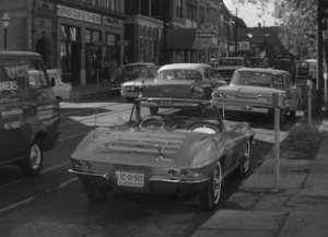
The familiar Corvette from the Route 66 television series parked on Olive in Gaslight Square, from episode that aired November 30, 1962 — click image for more detail at IMDB.
When I moved from Oklahoma City to St. Louis in 1990 our long-time neighbor across the street told me of his visits to Gaslight Square in the 1960s. By the time I’d arrived the buildings on the 2-block stretch of Olive were boarded up. I settled just West of there, on Lindell near Euclid. Euclid Ave, in the 90s, seemed to attract crime. Now it’s the greater downtown area — specifically Washington Ave.
First, a look at Gaslight Square:
By summer 1960, it was the place to be for beats, preppies, well-dressed adults, street troubadours and tourists. Olive pulsed with a happy cacophony wafting from places called the Crystal Palace, Left Bank, Laughing Buddha, and Dark Side. Jack Carl dished pastrami and genial abuse at 2 Cents Plain. A row of columns outside Smokey Joe’s Grecian Terrace anchored the landscape.
On March 24, 1961, the St. Louis Board of Aldermen anointed the obvious by renaming two blocks of Olive as Gaslight Square. Laclede Gas Co. later installed 121 gas streetlights, adding flicker to the buzz.
By summer 1961, Gaslight was noisier with more restaurants, taverns, nightclubs and shops. Some of the antiques dealers were squeezed out by rising rents. “The old gang doesn’t come around anymore, but perhaps it is a necessary evil of growing,” Massucci said as cash registers jingled.
Big and future names in show biz played the square. An 18-year-old singer named Barbra Streisand was warm-up for the Smothers Brothers. Allen Ginsberg recited poetry to mellow jazz. Miles Davis and Singleton Palmer were regulars. Earnest ministers opened the Exit, a coffee shop promising meaningful discussion and “jazz liturgy.”
But the crowds also attracted purse snatchers, car thieves and worse. On Dec. 30, 1964, Lillian Heller was fatally shot in a robbery in the vestibule of her apartment building at 4254 Gaslight, just east of Boyle. Heller, 61, and her husband, John, were artists.
Police added patrols and promised security. Young people flocked to discotheques such as Whisky a Go-Go, where hired dancers gyrated on platforms. But throbbing recorded music was drowning the live clarinet riffs. It became too crass and too much.
The old clubs began closing. Laclede doused some of the gas lights in 1967 for failure to pay. Police made drug arrests and thwarted a desperate bid to save the strip with topless waitresses. The Exit gave up the spirit in 1969, about when cultural pathologists pronounced the end of Gaslight. (Post-Dispatch)
Gaslight Square concentrated a lot into a couple of blocks of Olive. This concentration of money and activity attracted those who wanted some of that money. Rising crime became too much for some so it began to die.
There are parallels to current events, but there’s time to avoid going down the same path. Ever since the Washington Ave streetscape was completed about 15 years ago (Tucker to 18th), so much attention has been focused on a tiny area.
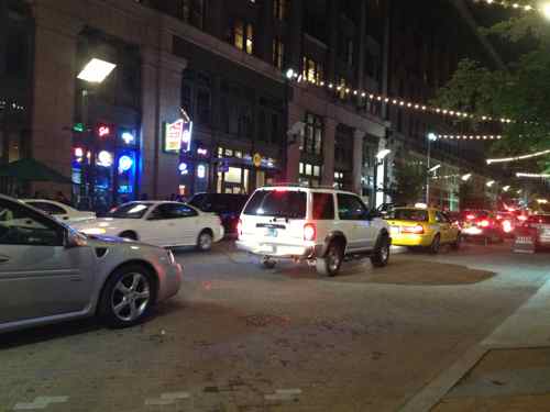
From 2014: Weekend nights traffic gets backed up on Wash Ave between Tucker (12th) and 14th
The solution is to put less focus on Washington Ave, but also do like many cities: divide downtown/downtown west into geographic districts. Examples: Toronto, Oklahoma City, Kansas City. This has been talked about for years but it has never happened.
Some possible districts include:
Garment District
City Museum District
Ballpark Village District
Convention District
Union Station District
Columbus Square District
Library District
Central Business District
Arch District
MX District
None should have “downtown” or Washington Ave” the name. Sure, crime will still happen, but this way an entire area won’t get stigmatized by something that happens 1-2 miles away. Branding districts could help with marketing efforts.
AARP Livibility Index
The Livability Index scores neighborhoods and communities across the U.S. for the services and amenities that impact your life the most
Built St. Louis
historic architecture of St. Louis, Missouri – mourning the losses, celebrating the survivors.
Geo St. Louis
a guide to geospatial data about the City of St. Louis