Nineteen year ago I started this blog as a distraction from my father’s heart attack and slow recovery. It was late 2004 and social media & video streaming apps didn’t exist yet — or at least not widely available to the general public. Blogs were the newest means of …
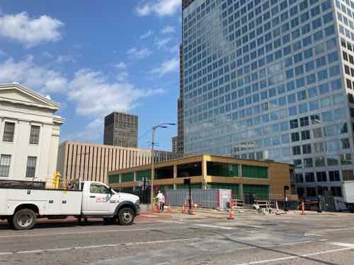
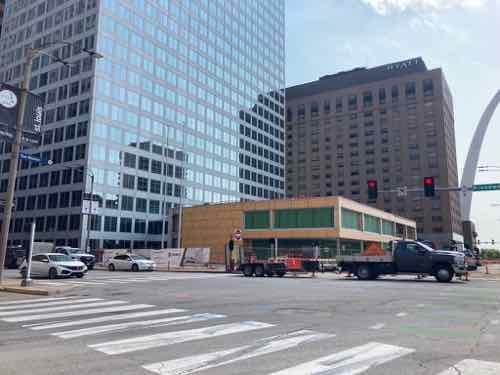
The new NGA West campus , Jefferson & Cass, has been under construction for a few years now. Next NGA West is a large-scale construction project that will build a new facility for the National Geospatial-Intelligence Agency in St. Louis, Missouri.This $1.7B project is managed by the U.S. Army …
Book publisher Island Press always impresses me with thoughtful new books written by people working to solve current problems — the subjects are important ones for urbanists and policy makers to be familiar and actively discussing. These four books are presented in the order I received them. ‘Justice and …
This post is about two indirectly related topics: the new Siteman Cancer Center building under construction on the Washington University School of Medicine/BJC campus and an update on my stage 4 kidney cancer. Let’s deal with the latter first. You may have noticed I’ve not posted in three months, …
September 24, 2021Books, Featured, TransportationComments Off on New Book — ‘Curbing Traffic: The Human Case for Fewer Cars in Our Lives’, by Melissa Bruntlett and Chris Bruntlett
This is the first of three books I received in July, so they’re newish. My health insurance is better now so I’m getting caught up.
I’ve posted before about my interest in electric cars, but also interest in and use of public transportation. My electric “vehicle” is a 2008 power wheelchair which I use in combination with public transit. The able-bodied can use a bike with transit, instead of a wheelchair.
Like so many others, I realize switching all internal combustion vehicles for electric ones isn’t going to solve the major problems with the automobile: they require a lot of space, for example. Today’s newish book looks at reducing the number of cars on our roads and filling our cities on huge surface lots or parking structures.
In 2019, mobility experts Melissa and Chris Bruntlett began a new adventure in Delft in the Netherlands. They had packed up their family in Vancouver, BC, and moved to Delft to experience the biking city as residents rather than as visitors. A year earlier they had become unofficial ambassadors for Dutch cities with the publication of their first book Building the Cycling City: The Dutch Blueprint for Urban Vitality. [see August 2018 post on their first book here.]
In Curbing Traffic: The Human Case for Fewer Cars in Our Lives, Melissa and Chris Bruntlett chronicle their experience living in the Netherlands and the benefits that result from treating cars as visitors rather than owners of the road. They weave their personal story with research and interviews with experts and Delft locals to help readers share the experience of living in a city designed for people.
In the planning field, little attention is given to the effects that a “low-car” city can have on the human experience at a psychological and sociological level. Studies are beginning to surface that indicate the impact that external factors—such as sound—can have on our stress and anxiety levels. Or how the systematic dismantling of freedom and autonomy for children and the elderly to travel through their cities is causing isolation and dependency.
In Curbing Traffic, the Bruntletts explain why these investments in improving the built environment are about more than just getting from place to place more easily and comfortably. The insights will help decision makers and advocates to better understand and communicate the human impacts of low-car cities: lower anxiety and stress, increased independence, social autonomy, inclusion, and improved mental and physical wellbeing.
The book is organized around the benefits that result from thoughtfully curbing traffic, resulting in a city that is: child-friendly, connected, trusting, feminist, quiet, therapeutic, accessible, prosperous, resilient, and age-friendly.
Planners, public officials, and citizen activists should have a greater understanding of the consequences that building for cars has had on communities (of all sizes). Curbing Traffic provides relatable, emotional, and personal reasons why it matters and inspiration for exporting the low-car city. (Island Press)
This isn’t about eliminating all cars, just moving to fewer cars than today. Here are the authors explaining their view:
You can read the full introduction and much of the first chapter (The Child-Friendly City) on Amazon. (Kindle preview is longer than the softcover preview.)
August 26, 2021Environment, FeaturedComments Off on We Saved Money On Our Electric Bill By Switching Rate Plans
For years there was no financial incentive to reduce electricity use during peak periods. Running the dryer & air conditioning while cooking dinner at 5pm weekdays cost the same as doing them at other times. With Ameren Missouri’s new smart meters and Tine of Use (TOU) rate plans reducing electric use during peak demand can save money and reduce peak load on the grid.
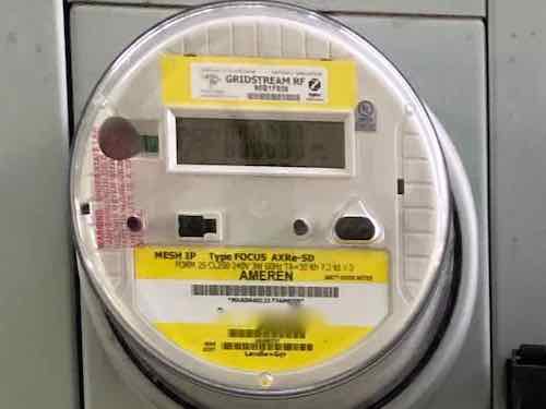
A smart electric meter is needed for Time of Use (TOU) rate plans.
At the end of June I posted about signing up for one of the new Time of Use (TOU) rate plans –initially only one was available. Halfway into that billing cycle the other, advanced TOU rate plans became an option for us. I quickly changed plans effective the next cycle.
Now we’ve completed two billing cycles on a basic and an advanced TOU rate plan. Because I’m a spreadsheet nerd I was able to figure out our savings compared to the flat rate plan most still have. The primary savings we realized wasn’t on rates, but on reducing the amount of kWh we used in the billing cycle. Related was a savings on the taxes & fees as all but one are based on kWh. We also saved on the energy used, more with the advanced rate plan than the basic.
Here are some of the details:
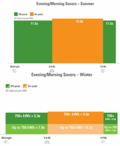
Our first TOU billing cycle was the Evening/Morning Savers plan. Like the flat rate, this plan is considered basic. The difference between the peak & off-peak energy is minimal.
For comparison, the summer anytime rate is 11.8¢ per kWh.
This cycle ran from 6/23/2021 through 7/22/2021, the July cycle. We used 652 kWh during this billing cycle. Last year we used 922, in 2019 1,206 — a nearly 30% less than the same cycle last year. Using less energy saved us $31.86 on energy, compared to last year. We saved another $2.31 on additional fees: fuel adjustment, energy efficiency, and renewables. We saved $1.33 on the St. Louis municipal service charge. Add it all up and just reducing our energy use saved us $35.50 for the July billing cycle.
We used 465 kWh off-peak, and 187 kWh peak during the cycle. We saved another $1.02, which isn’t much. However, being on a TOU plan got me thinking about more ways to save that I wouldn’t have done otherwise. Added to the above we saved $36.52, nearly 30%!
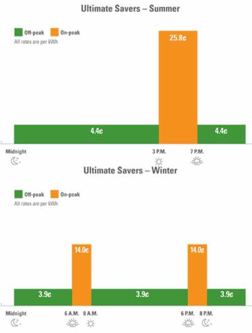
With the next billing cycle we were now on the Ultimate Savers TOU rate plan.
Ultimate Savers is Ameren’s most advanced plan, with the biggest differences between peak & off-peak raters. The trick with this plan is an additional “demand charge” based on the hour (6am-10pm) of highest use during the cycle.
I was very nervous about what our bill would be, entirely because of the demand charge. Toward the end of the cycle Ameren’s reports improved significantly, allowing me to see we’d save money. Or at least not spend more — a concern I had initially
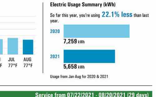
Like the July cycle, we reduced our energy use compared to the August 2020 cycle (586 kWh vs 978 kWh) — a 40% reduction! We also used less electricity in August compared to June & July.I’m not going to go through the math again to demonstrate the savings compared to last year, but is was 40% less.
We used 529 kWh of off-peak energy, for a cost of $23.12. Our peak energy was 50 kWh, $12.90. Only 8.6% of our energy was used during peak times — this was mostly cooking dinners. Our hour with the highest kWh used was 3.6 kWh. With a rate of $7.03/kWh our demand charge was $25.31 — this was higher than either our peak or off-peak use. Compared to the Anytime flat rate we saved $6.99 before fees/charges, an effective rate of $0.106 vs $0.118 per kWh.
What I don’t is if we’d be better off on one of the other two advanced TOU rate plans, neither have a demand charge. In a few months Ameren will crunch the numbers and let us know the best plan for us.
After February 2021 we were using slightly more electricity than last year, but now we’re using 22% less than we did at this point in 2020.
A smart meter like our, above, is required to change to a TOU plan from the Anytime flat rate. See Ameren’s rate options here. In a future post I’ll share other reports from Ameren that detail where we’re using our electricity — our cooking is as much as cooling!
Office vacancy rates are high now, especially in downtown St. Louis.
Office vacancy is up across the metro area, averaging 16.9% in the second quarter of 2021 compared with 11.8% in 2020. Rents for offices outside of downtown declined nearly 4% from the end of 2020 through the second quarter of 2021, according to commercial real estate firm Cushman & Wakefield.
Vacancy downtown has risen more than 1 percentage point in the past year, to 20.8% from 19.3% in the second quarter of 2020. And rents have fallen by more than 1% to $19.48 per square foot. (Post-Dispatch)
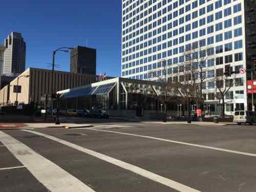
One downtown office tower, recently acquired by a local fund, is taking steps to reverse years of increased vacancy.
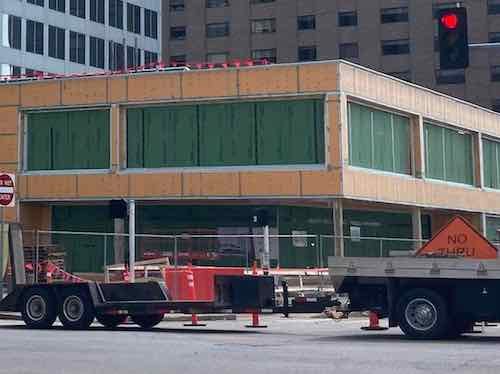
The 4th & Chestnut corner of 100 North Broadway. The former bank pavilion is getting a long-needed update.
Readers might recall my December 2015 blog post on this building. In that post I suggested connecting the low pavilion portion to the adjacent sidewalks, orienting the interior space to take advantage of the location and views.
To refresh your memory, here’s a view of what the exterior looked like for the first 45 years. Awful, right? Zero connection to the sidewalks. The east & west plazas weren’t inviting. December 2015
I sent the then building owner, a San Diego-based capital firm, my post at the end of 2015. They responded the next month, I met a local property manager on site. They sent me a nice fruit basket from Harry & David. They didn’t do anything.
Looking at the building from the NW corner of the Luther Ely Smith Square. December 2015. This is the same corner as the first corner, above.
According to KSDK more tenants left, the California owner defaulted, and by February 2019 the lender had taken over the property. A new local owner purchased the tower and apparently recognized the need for major updates to the prominent pavilion, inside & out.
The SW corner of the property, at Broadway & Chestnut. This is diagonally across from Kiener Plaza, which reopened in 2017 after a major redesign.
The new owners logically hired one of the remaining tenants to update the interior & exterior:
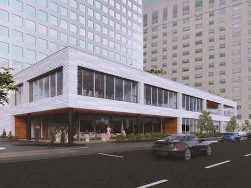
Larson Capital Management has engaged Trivers to make both interior and exterior building improvements to the 2-story atrium structure and surrounding plazas and streetscape to comprehensively update and reposition the Broadway Tower as a premier office building destination in downtown Saint Louis.
Exterior improvements include removing the “greenhouses” and reimagining the Atrium façade materiality and line of enclosure, updated entrances and entry canopies, surrounding site improvements and landscaping, and public art and placemaking components creating public outdoor destinations.
Interior improvements are geared toward creating an abundance of tenant amenities including a best-in-class conferencing center, co-working lounges with hospitality support, a walking track, and access to outdoor work spaces. The Atrium will also include a new café with indoor/outdoor seating connected to the west plaza along Broadway, a new monumental stair, a large greenwall, building management offices, new security desk and updated elevator lobbies, restrooms to support the proposed uses, and comprehensive lighting, casework, and finishes upgrades. (Trivers Architects)
In 2015 I imagined a few restaurants to fill the space, but tenant amenity space will be critical to filling vacancies. There will be one cafe, on the corner shown above.
This is a crop of the previous photo, you can see how the ground floor is set back so the upper level provides shade, room for cafe tables.
The artist rendering shows this corner. The exterior cladding on the pavilion will offer more texture than the tower portion.
I’m looking forward to seeing the finished product, experiencing the revised plazas, eating at the cafe. The upper level features a covered outdoor space on the opposite corner, facing the Arch. Not sure if that will be public or tenant-only. Either way, to pedestrians at 4th & Chestnut it’ll be perceived as inviting.
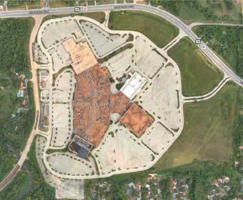
Vacant 422,533 square feet enclosed mall > tear down mall.
Lack of a major grocery store > include site for ALDI-sized grocery store on edge of master plan. Building should be easily connected to new sidewalk network.
MetroBus stops along both sides of Lindbergh Blvd adjacent to the site are just shoulder on a state highway, discouraging pedestrian use. No pedestrian infrastructure or access to site > reroute MetroBus through the redesigned site and/or add pedestrian infrastructure along this stretch of Lindbergh Blvd.
The Fox Manor subdivision is immediately south of the site, downhill. It only has one way in/out — onto Lindbergh Blvd for cars only > connect the two dead end subdivision streets to new public streets on the site.
Finding a single developer to build out the nearly 145 acre site is proving difficult. Of course, it’s massive. It’s way too much for one entity to take on. Yet most people think if one developer won’t build the mixed-use neighborhood that area residents want then one developer should be allowed to development an awful warehouse complex. Wrong!
The best places in the St. Louis region weren’t built at one moment, by one developer. No, land owners subdivided their land and created building lots, putting in streets & utilities to support those who would eventually buy a lot and build on it. This is how downtown St. Louis was developed, as well as Kirkwood MO, Florissant MO, Belleville IL. Nearly every pre-WWII downtown or commercial district developed in this manner, over time. New Town at St. Charles was planned by one developer, who also built some buildings. But not all.
St. Louis County needs to master plan the entire site, put in connecting streets & utilities, rezone the site and adopt a form-based code to guide the build out over the next 10-15-20 years. Subdivide the land so a grocery store could own their parcel. An insurance agent might build their housing unit over their office space. A multi-family housing company might build a few buildings with apartments. A home builder might build on some single family lots.
“There is only one way to eat an elephant: a bite at a time” — Desmond Tutu
Ok. don’t eat an elephant…or even kill one. And don’t expect developers to bite off more than they can chew.
For comparison most of downtown’s central business district would fit in the same 145 acre site: From the Arch grounds to 8th, from Market to Washington Ave.
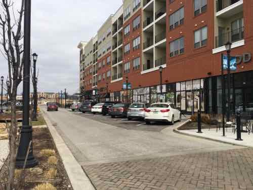
Ballpark Village is 10 acres and the Cardinals had to split that up into multiple phases because they learned they couldn’t do it all at once. The Streets of St. Charles project is a 27 acre suburban mixed-use project and it is being phased in.
The Streets of St. Charles, 2016
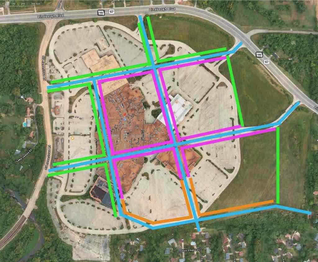
Below is my crude schematic showing new streets (blue) connecting to all 7 existing site access points, including 2 dead end streets in the residential subdivision to the south. The pink is commercial and/or mixed use, the orange is residential without commercial. The green around the perimeter is a green buffer around the perimeter with a walking path, water, fruit trees, etc.
Click image to see larger version.
My roads shown above in blue would be initial roads. Maybe. At a minimum three of the seven site access points should be connected: one off Lindbergh Blvd, one off Old Jamestown Rd, and one of the two dead end streets in the Fox Manor subdivision. My idea the initial streets 1) have an intersection in the commercial area and 2) connect to the residential subdivision.
Eventually there would potentially be many more streets given the size of the site, but that can happen over time as demand warrants.
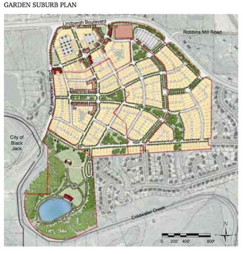
A concept from a decade ago with more of the site built out than what I envision.
My main point is the St. Louis County Port Authority, as property owner, should plan it out, put in some streets and utilities and begin to sell the land lot by lot. I think most everyone would agree a well-connected mixed-use neighborhood with a grocery store is the best possible outcome. I just don’t see it happening all at once, but incrementally over time.
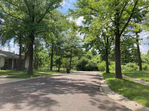
My blog posts about Jamestown Mall are few. In 2011 a poll followed by the poll results with a few thoughts. In 2016 I posted that it had been two years sine the mall permanently closed. My 2011 visit was done while the mall was open, I arrived via MetroBus using my power wheelchair. As it had been over a decade since my last visit, we recently drove up to the dead mall to reacquaint and get current photos. Driving allowed me to take in more of the overall area.
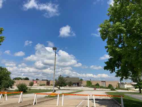
The first site entrance going clockwise is the southern entrance off of Old Jamestown Road. Designed for vehicles pedestrians from the areas to the south have also used this entrance despite lacking an accessible route into the site.
Some things have changed in the last decade, others have not. Today I want to share with you my approach to analyzing the site, its surroundings, listing the various problems I see, and what options exist for moving forward. The 2nd part will be my conclusion, offering a solution.
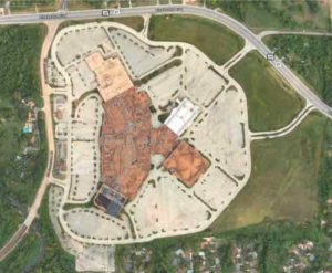
Aerial view of the site and immediate surroundings. Source: Apple Maps. Click image to view aerial in Google Maps.
Construction began on the mall in 1972. Its anchor stores at the time were Sears and Stix Baer & Fuller, a local chain based in nearby St. Louis. The Stix store was converted to Dillard’s in 1984 after Dillard’s acquired the chain. Famous-Barr (now Macy’s) was added as a third anchor in 1994, and two years later, JCPenney relocated to the mall from an existing store in Florissant. A movie theater was also added in the 1990s.
Jacobs Group sold the mall to Carlyle Development Group in 2003. At the time, the complex was approximately 30 percent vacant. In April 2006, Dillard’s Inc. announced the closure of the Jamestown Mall store, and Sears closed two years later.
Carlyle announced redevelopment plans in 2008. Under these plans, the former Dillard’s would be converted to offices, and its wing would be closed to retail. A year later, St. Louis County hired researchers from the Urban Land Institute to analyze the mall’s viability as a retail center. The study found that the center was no longer viable as a shopping mall because it overlapped with existing retailers in the area. These plans were canceled in 2009 when the mall developers lost financial support from the county following an attempt to auction the former Dillard’s store. Further plans in 2010 called for the demolition of everything except the JCPenney and Macy’s stores, with the rest of the complex to be re-developed as a mixed-use center. In June 2011, a furniture store called Central States Liquidation opened in the former Dillard’s. The JCPenney Outlet store, which was renamed JC’s 5 Star Outlet, csed in late 2013.
In late 2012, gas service to the mall was shut off but later restored. The mall’s closure was announced in November 2013 due to the heat being shut off. The closure of the Macy’s store was announced in January 2014, leaving the mall with no anchors. Jamestown Mall finally closed it doors on July 1, 2014.
For a long time one or more anchor stores had different owners than the remainder of the mall, but in 2017 the St. Louis County Port Authority acquired ownership of the mall and parking to make redevelopment easier. The exception is a small outparcel strip between the two driveways connections to Old Jamestown Rd., on the west side of the site. Appropriately, this is owned by a funeral home.
Here are some basics for analysis:
Municipality: None, unincorporated St. Louis County
School District: Hazelwood
Fire Protection District: Black Jack
Mall building: 422,533 square feet
Main site: 142.42 acres
Outlot building: 2,509 square feet
Outlot site: 2.09 acres
Total area of combined site: 144.51 acres (0.2258 square miles)
Site access points: seven total from public streets, five mall drives plus two dead end streets in Fox Manor subdivision. One of the five mall drives includes a signalized intersection. Photos of each below.
Surrounding areas include older & newer suburban housing, largely stable middle class. Part of the surroundings become rural very quickly. The area is lacking a major grocery, the nearest is 3.6 miles from the site.
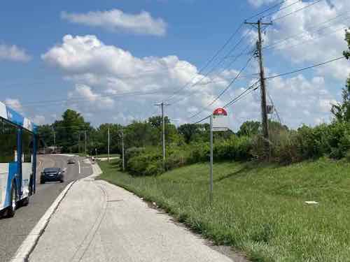
Vehicular access is excellent, but pedestrian access is poor. The only pedestrian access is the public sidewalk on the east side of Old Jamestown Rd., this connects to the south. There are numerous MetroBus stops in both directions along Highway 67 (aka Lindbergh Blvd) but no pedestrian infrastructure exists to get to/from the stops. Photos of some orphaned bus stops below.
Topography: Mostly flat where mall sits, otherwise gently sloping downhill to the south. Prior to the mall the area was rural, with ponds and nothing altering the natural flow of rainwater to Coldwater Creek on the south, just beyond the site boundaries. The topography isn’t what it was before the mall, it was changed to create a mostly level spot for the building a parking lots.
By comparison the mixed-use Streets of St. Charles project is 27 acres. Again, the Jamestown Mall site is 144.51 acres — more than 5 times larger!
The most recent proposal was for the mall site a massive warehouse operation, which was met with local opposition.
The St. Louis County Port Authority, which owns the 145-acre site near Missouri highways 67 and 367, will issue a request for proposals next month for a contractor to abate the property, Chairman John Maupin said, calling it the first step to tearing down the former mall building.
Demolition would be a “very expensive process,” Maupin said, but it is necessary to attract potential buyers, as the building is blighted “beyond any sort of redemption. Pressed for a cost estimate, Maupin said clearing the entire site could cost up to $10 million.
The announcement comes a week after a Kansas City-based developer’s plans to turn the mall into a large warehouse site were scrapped amid opposition by Councilwoman Shalonda Webb, who represents the area. Webb said residents overwhelmingly prefer a mixed retail site or community center. (Post-Dispatch)
I’m very happy the awful warehouse proposal is dead, and glad the old mall will be razed and the site cleaned up. It’s excellent area residents didn’t give into the tired notions that “anything is better than nothing” and “anything is better than what it there now.”
So what are the options:
One option is do nothing after demolition, let nature take over the land again. Another is to reopen it up to bidders for whatever they propose. A variation is reopen for bidders with some limitations, such as including a mixed-use component. It’s very clear the area residents prefer a mix-use project, not a single use. They also would like a grocery store, which is necessary given how far away the nearest is.
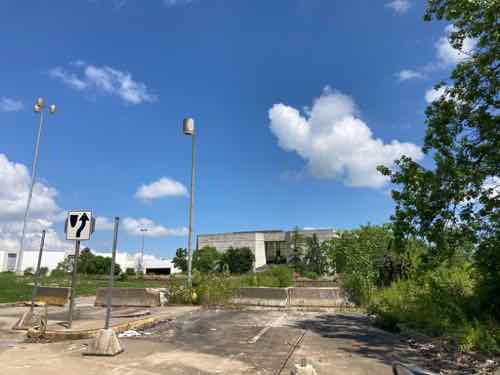
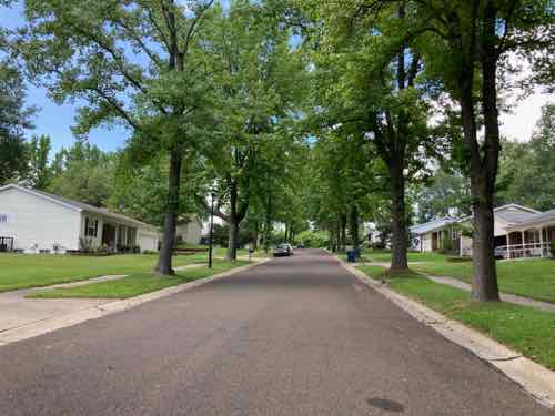
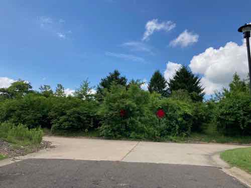
In the meantime, below are recent photo of the 7 site access points. Also below are examples of bus stops just on a highway shoulder.
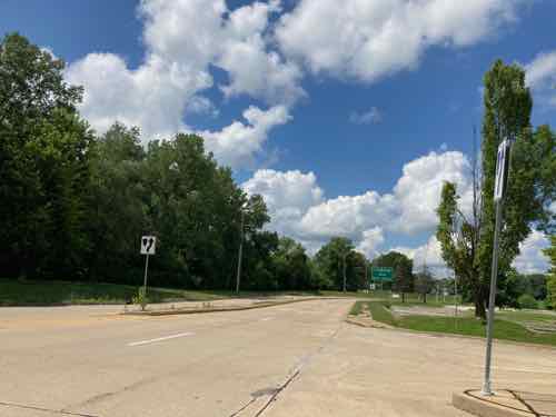
The northern mall entrance off Old Jamestown Rd
Looking north toward Lindbergh Blvd
Bus stop on eastbound Lindbergh Blvd, just east of Old Jamestown Rd. This bus stop wouldn’t work for those of us who use a mobility device.
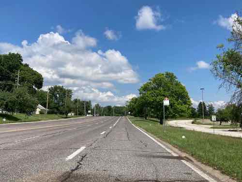
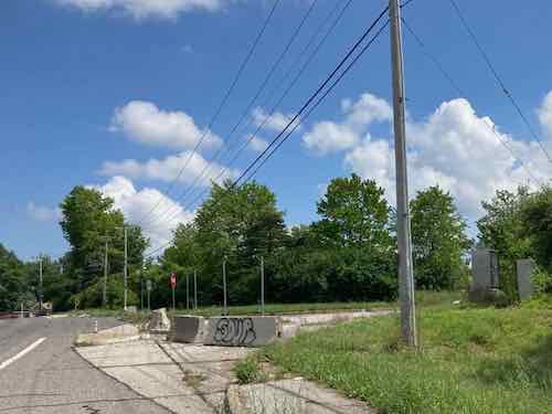
Contining east on Lindbergh Blvd another auto drive
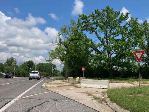
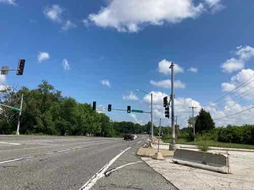
Next entrance is a signalized intersection
Followed by another bus stop of limited use. As this is a state-controlled highway they should be the ones to install pedestrian infrastructure.
And the final mall entrance…for vehicles
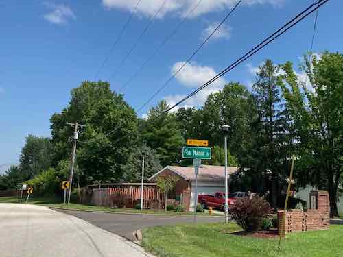
Up next is the Fox Manor subdivision. The only vehicular entrance is this onto four fast lanes of Lindbergh Blvd.
Brown Fox Dr has nice mature trees, but only 9 houses before dead ending at the mall site. The original developer planned to expand this direction.
Fox Chase Dr also has nice mature trees and 10 houses.
It also dead ends at the mall site. The Fox Manor has numerous cultural-de-sac streets that back up to the mall site, but two streets were planned for expansion.
Houses on the cul-de-sac of Silver Fox Dr are the closest to the existing mall structure.
AARP Livibility Index
The Livability Index scores neighborhoods and communities across the U.S. for the services and amenities that impact your life the most
Built St. Louis
historic architecture of St. Louis, Missouri – mourning the losses, celebrating the survivors.
Geo St. Louis
a guide to geospatial data about the City of St. Louis
 This is the first of three books I received in July, so they’re newish. My health insurance is better now so I’m getting caught up.