Nineteen year ago I started this blog as a distraction from my father’s heart attack and slow recovery. It was late 2004 and social media & video streaming apps didn’t exist yet — or at least not widely available to the general public. Blogs were the newest means of …
The new NGA West campus , Jefferson & Cass, has been under construction for a few years now. Next NGA West is a large-scale construction project that will build a new facility for the National Geospatial-Intelligence Agency in St. Louis, Missouri.This $1.7B project is managed by the U.S. Army …
Book publisher Island Press always impresses me with thoughtful new books written by people working to solve current problems — the subjects are important ones for urbanists and policy makers to be familiar and actively discussing. These four books are presented in the order I received them. ‘Justice and …
This post is about two indirectly related topics: the new Siteman Cancer Center building under construction on the Washington University School of Medicine/BJC campus and an update on my stage 4 kidney cancer. Let’s deal with the latter first. You may have noticed I’ve not posted in three months, …
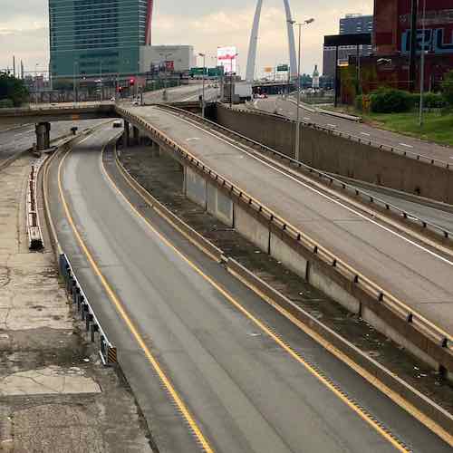
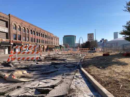
Urban highways & interstates allow drivers to get from point A to point B quicker than had they taken surface streets, but they’re also a major divider between the existing neighborhoods they cut through. In the late 1950s the downtown’s 3rd Street Parkway was being extended north, eventually connecting with the new Mark Twain Expressway (aka I-70/I-44) in July 1961.
I live on the west side of the highway, but I can stand in my kitchen and see Broadway & Cass, on the east side of the highway. I know first hand how the highway divides the historic north riverfront from my neighborhood, Columbus Square.
Looking south from the Cass Ave bridge over I-44, June 2020. The lane center is a southbound express lane, to the right is the express lane exit ramp to southbound Broadway.
Ideally we’d remove urban interstates and weave our neighborhoods back together, but that’s never going to happen. What should happen is when we rebuild crumbling infrastructure we add connections civil engineers in the 1950s never considered at the time the highways were planned.
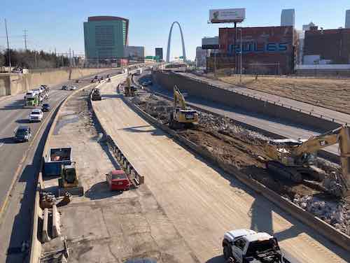
The same view Monday with southbound Broadway bridge and the exit ramp gone.
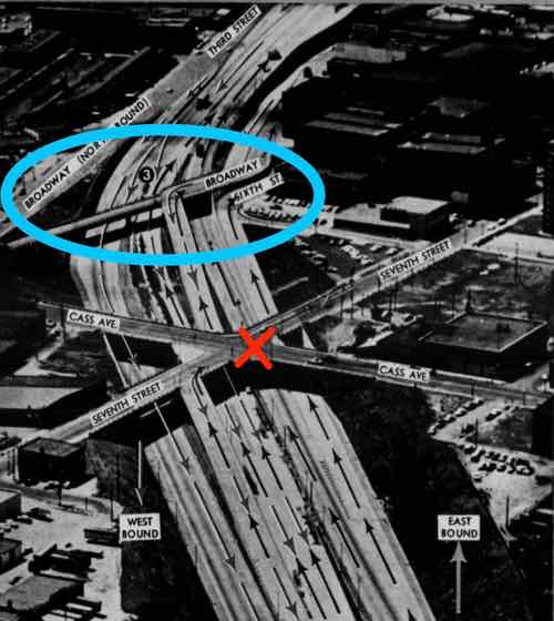
The blue oval is the southbound Broadway bridge, the red X is where Csss & 7th were connected until construction began for the Stan Musial Veterans Memorial Bridge. Post-Dispatch July 9, 1961, p161.
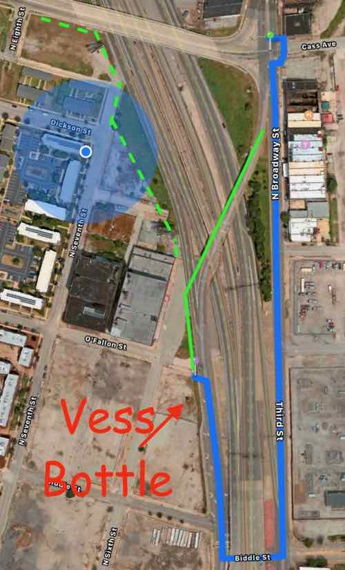
The distance from Broadway & Cass to Broadway & O’Fallon is only 2/10 of a mile, but the distance required for the last 60 years has been double that — 4/10 of a mile.
The Missouri Department of Transportation supports pedestrian facilities:
MoDOT works with planning partners to create transportation facilities that work for all users because we value bicycle and pedestrian travel. Accommodating for bicyclists or pedestrians may be as simple as providing a well-designed road that all road users share or as complex as a separate-grade structure, such as a bridge. Developing appropriate facility design for nonmotorists depends on a variety of geometric and operational factors that are inter-related, such as available right-of-way, projected traffic counts and adjacent roadway design speeds.
We strive to integrate nonmotorized travel into the existing system to provide connections where none exist to promote efficiency and to focus on a primary concern—the safety of those who depend on walking or bicycling to reach their destinations. (MoDOT)
Unfortunately MoDOT failed to accommodate the needs of cyclists and pedestrians in the replacement. This is a huge mistake — it’ll be another 60+ years before we get another chance to reconnect these areas.
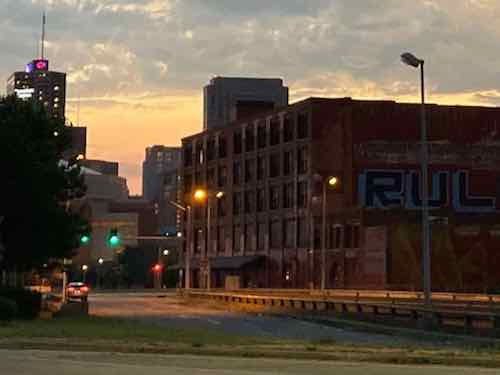
View from Broadway near Cass looking SW toward Broadway @ O’Fallon (just beyond building), June 2021
The buildings on the right are part of a National Register Historic District.
You might be thinking it would be too difficult to include a pedestrian sidewalk. The old bridge, removed over the weekend, couldn’t have easily been retrofitted. But when building the new bridge entirely from the ground up it is actually pretty easy.
Here’s the overview:
The blue circle is my location. The blue line represents the route required to walk from Broadway @ Cass to Broadway @ O’Fallon — twice as far as the direct route shown in solid green. The dashed green line is how to connect Cass to 7th & 6th streets. Apple Maps
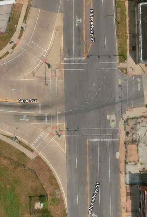
Now let’s take a look at the old bridge and highway exit ramps.
Broadway is only one lane per direction north of Cass, but it widens to 2 right turn lanes onto westbound Cass and 2 southbound lane to continue across the highway. One lane expands to four! Apple Maps
So 2 lanes of Broadway continued over the highway. The express lane exit is one lane but the Broadway exit is 2 lanes. Four lanes continue toward Cole before getting reduced to 2 further south.
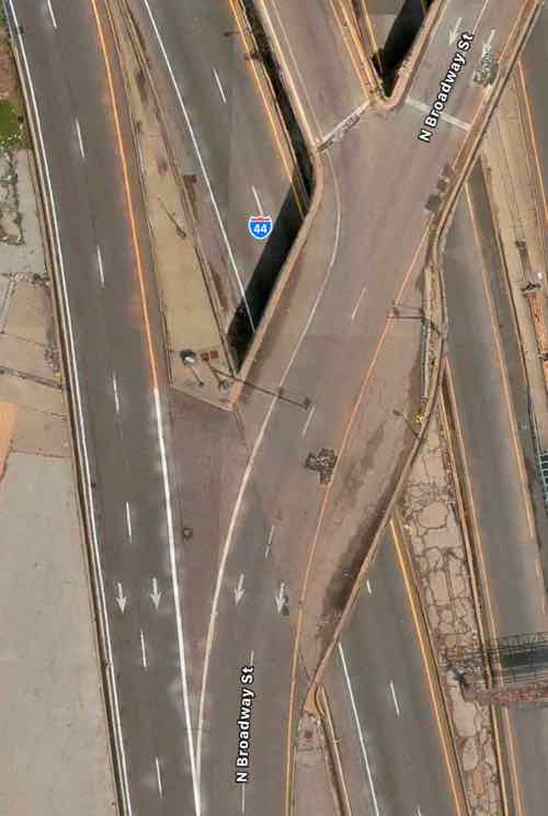
The solution is the one southbound lane of Broadway splits into 3 before Cass — one left, one right, one straight ahead. This means the same width bridge can also accommodate bikes & pedestrians. The traffic exiting the southbound express lane and the highway have plenty of length for drivers to decelerate. Rumble strips (or similar) can be used to communicate to the driver to slow down as they approach Broadway. The 2 highway exit lanes can narrow to one before Broadway. Not sure if signals are necessary or just a flashing red light and notices to yield to pedestrians.
I would like to see Broadway south of Cole to return to two-way traffic in the future, so I’d like the new bridge to accommodate 2-way traffic and pedestrians on one side.
Again, I’m trying to connect two areas that have been separated for over 60 years. Both have enormous potential for redevelopment — new construction & adaptive reuse to the south and mostly captive reuse to the north. I’d love to see football fans have pre-game drinks at Shady Jack’s Saloon and then walk down to the Dome to see the St. Louis Battlehawks when the XFL returns under new ownership.
The Texas Eagle train uses 2-level trains like this one, the Lincoln Service to/from Chicago uses a one level train.
In October 2021 I booked an Amtrak trip to Chicago for a weekend next month. At that time the trip was scheduled to take 5 hours 40 minutes to Chicago Union Station, via Lincoln Service. This is faster than it has been over the years — improving every year since the American Recovery and Reinvestment Act of 2009 was signed by president Obama. Amtrak recently revised my trip — it’ll now take only 5 hours 25 minutes. Fifteen minutes quicker than before!
Amtrak will implement a schedule change for Chicago to St. Louis Lincoln Service and Texas Eagle trains, effective December 13.
These schedules reflect a maximum authorized speed of 90 mph for Trains 300 – 307 and Trains 21 & 22. Chicago to St. Louis corridor travel times are reduced by approximately 15 minutes, end-to-end.
Updated schedules now on Amtrak.com reflect these changes, as do new bookings, eTickets and other boarding documents.
This is a step toward 110 mph schedules that are planned for the next 12 to 18 months. These improvements use federal grants and other funds from the Illinois Department of Transportation. (Amtrak)
These speeds aren’t close to high-speed rail experienced in other parts of the world, but it is very welcomed.
Driving a car is still faster, but it’s exhausting and very expensive to park in Chicago, station to station is 297 miles, requiring 4 hours 20 minutes. Of course, that’s assuming no restroom/eating/stretch breaks.
Kansas City is closer to St. Louis than Chicago is, so you’d think both driving & train travel would be less. Driving is 250 miles — 47 miles less than to Chicago, requiring 3 hours 37 minutes. Makes sense. The train trip to Chicago, however, is 5 hours 40 minutes.
Yes, the trips used to take the same amount of time even though one is closer. Now the STL to CHI train is faster. Once more improvements and speeds of 110 mph are achieved the time difference of traveling to Chicago compared to Kansas City will be even greater.
It would be nice to see similar improvements made to better connect St. Louis and Kansas City, spanning the width of the state.
Monday’s post Bus Rapid Transit (BRT) Not Right For St. Louis certainly ruffled a few feathers — at least among non-transit riding civic boosters. Lots of good discussion on the Facebook post. What we need next is to go through specifics one by one to see if there is any consensus. BRT has been implemented worldwide with great success. In general, BRT projects in the United States have been less robust than in other countries. That’s ok.
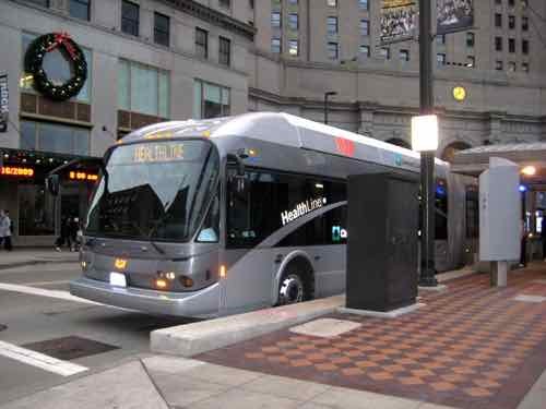
The Healthline in Cleveland, 2015. Click image to see my 4th post on Cleveland’s Healthline from November 2015.
My previous post was simply saying we can’t have a gold-level bus rapid transit system, per the Institute for Transportation & Development Policy (ITDP) Scorecard. To date no BRT system in the USA has achieved a top gold rating. The ITDP has ranked 10 BRT lines in the US with the following results:
Countless others being marketed as BRT don’t even qualify for a “basic” designation. Ouch. I guess as long as the users are pleased with the line compared to a conventional local bus then it doesn’t really matter what it’s called. Interestingly none of the 10 in the US have BRT as part of their name. Our light rail system has two lines: Red & Blue.
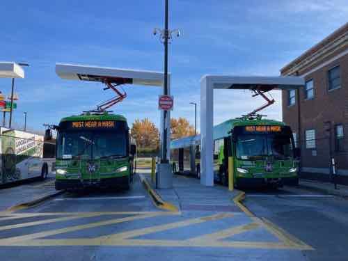
Two battery electric 60 foot articulated buses recharging in November 2021. The right bus just arrived, the left bus is about to leave. Note that these buses have a unique color scheme to separate them from regular local buses.
Perhaps we come up with some criteria to use for calling a very high frequency bus route by a color name rather than the legacy bus number. For example, our busiest bus route (#70 Grand) could be the Green Line. Maybe if we made big changes to the #95 Kingshighway bus route it becomes the Orange Line? And so on. Then we wouldn’t need to quibble over the BRT term.
Where I think we can agree is our next big transit investment in the city will have rubber-tired transit vehicles, not rails. How St. Louis County invests their transit dollars is a separate issue, they might opt for light rail in a street and/or an extension south from the Shrewsbury station. Today’s post is focused on the city, though applicable if the county considers a BRT-esque bus project.
Beyond the marketing name & tires there are many other items to be considered:
Type of propulsion (diesel, hybrid, compressed natural gas (CNG), fuel cell electric, battery electric, overhead cable electric (commonly known as a trolleybus)
Fare collection (on-board, off-board, honor, no fares)
Boarding (curb height or raised platforms for level boarding; front door only or all doors)
Stop intervals (2 blocks, 1/4 mile, 1/2 mile, more; if more than 2 block local will a local bus also run the route less frequently to serve those unwilling/unable to walk to the farther stops)
Stop locations: center of street, right lane, or a mix of both)
Let’s go through each, discussing pros and cons to consider when making decisions.
#1 Type of Propulsion
In 2022 I think we should invest only in transit vehicles with zero tailpipe emissions. That would eliminate diesel, hybrid and CNG. The three electric options each have their own pros & cons, infrastructure needs. Battery electric buses, like the 60 foot articulated buses on the 70 are presumably heavier than an electric trolleybus. Overhead wires vs increased wear & tear on streets and sourcing of rare earth metals. Battery electric buses (BEB) need to be quick charged during service, whereas the trolleybus doesn’t need to — but not everyone likes overhead wires. Some trolleybuses have small batteries to allow them to operate any from overhead wires. Hydrogen fuel cells are another option, not sure if one can go all day without refueling during the day. If so, is that feasible. Fuel cell buses are heavier than trolleybuses but presumably lighter than BEBs.
Metro has historically purchased buses from Gillig, but the new articulated battery electric buses used on Grand came from New Flyer. The latter offers more sizes and propulsion choices.
#2 Fare Collection
This is an important area because it determines how the stops are designed. First is getting our transit agency caught up on fare technology — assuming we’re going to continue collecting fares from users.
In August 2006 a Metro engineer explained the then-concept of smart fare cards to me.
That was in August 2006, at the opening of the most recent extension of the high-floor light rail. Metro’s Gateway Card finally appeared in spring 2018 — twelve years later. It has been almost four years now and nobody uses it. When I ride the bus or light rail I don’t see others tapping their cards. These cards are available for full fare & senior customers only — I think I’m still the only non-senior reduced-fare user with a Gateway Card.
Metro was working on a website login and app to go with the card, but it seems they’ve abandoned it in favor of a smartphone app to use for fare payment. Millions were spent changing bus fare boxes to allow cards to be tapped, and readers were placed at the entrances to the 38 MetroLink stations so security could see the green light as each person taps their card to enter. Huge investment of time & money for nothing. People do use the Transit app to buy digital tickets & passes.
I prefer having a reloadable card that calculates if my second tap qualifies as a transfer or new ride. I’ve seen systems that use both smart cards and apps. The goal for all is to not have fare payment holding up boarding, When I visit Chicago locals and the vast majority of visitors use their smart card — boarding is so much faster.
A faster bus route isn’t going to have the driver give those who paid more a daily transfer. Yes, currently every Metro bus in the region gets little pads of transfers to use for that date only. Massive waste of time & money that Metro continues. You’ll often see these as litter around bus stops, especially since most bus stops lack basics like a trash can.
Moving on…
Lets assume everyone has a smart card. By tapping it on a reader at MetroLink station entrances (off-board) or on the bus farebox (on-board) the appropriate fee is deducted from the card balance. If funds are insufficient it gives you a red light & buzzer instead of green.
Since opening in 1993 our light rail has had off-board honor system fare collection. In response to calls for turnstiles it’s going from an open platform to a closed system. If we’re going to build nice new bus stops for a rapid line we need to decide where the user taps their card. Currently bus riders using the smartphone app show the driver their valid ticket upon entering, but that wouldn’t work if boarding is allowed at all 3 doors (60 foot articulated).
Would bus stops for a new rapid bus route have the honor system for accessing the platform & bus? I can’t imagine that would go over well. If we want fare verification performed off-board that means turnstiles. The current smartphone app isn’t designed for use with turnstiles in mind.
#3 Boarding
Two questions here, both related to #2 above. Platforms level with the bus floor speeds up the boarding process for everyone, whereas curb-level boarding requires passengers to step up into the bus.
In the case of us disabled users (wheelchair, walker, etc) typically a ramp is unfolded to come down to curb level. The BRT scoring is better for smaller horizontal gaps between the platform and the bus floor:
Even corridors that have been designed to accommodate platform-level boarding could have gaps if the buses do not dock properly. A significant gap between the platform and the bus floor undermines the time-savings benefits of platform-level boarding and introduces a significant safety risk for passengers. Such gaps could occur for a variety of reasons, from poor basic design to poor driver training and technical opinion varies on the best way to minimize the gap. (ITDP)
Some buses designed for BRT use have a bridge that can pop out to close the gap, others the driver has to come set a lightweight bridge in place.
The other aspect of boarding is if everyone enters through the front door only, or all doors. If the decision is made to eliminate fares, have turnstiles to access the platform, or the honor system, then boarding can happen at all doors.
#4 Stop intervals
This is a big one. With my power wheelchair I can go miles without any issues — assuming curb cuts are in place, snow & ice are cleared, etc. But many are used to frequent bus stops, people who use walkers or a cane might struggle if their local bus stop no longer exists. They might already walk a good distance to reach the bus route. The solution in some cities is to have the BRT bus stop roughly every half mile while also operating a less frequent local bus. By having fewer stops you increase the possibility of having new development occur at these points, assuming zoning is sympathetic to requiring increased density at these spots. Fewer stops requires public & political buy-in to make it successful.
#5 Stop locations
Where the stop is located depends on where the bus operates. If it’s in the center of the right-of-way then obviously you’re going to have center platforms. Keep in mind some systems have a mix — some center, some right. Like our light rail vehicles, BRT vehicles usually have doors on both sides to accommodate different platform locations based on particular conditions. Having center dedicated lanes with center stations, even part of the length of the route, improves performance. If so you’ve got to make sure pedestrians crossing to/from the center are safe from motorists. The nice thing about center platforms is if you want to go the opposite direction from where you are, you only need to cross half the street to get to the stop.
Closing Thoughts
Even if the ITDP doesn’t consider a big transit investment BRT the only two groups that matter are the public and the feds — the ones determining if a project qualifies for matching funds. Other regions are ok with their BRT line not meeting ITDP’s minimum criteria to be considered. It’s up to all of us to participate, listen to others.
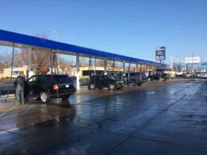
Much of the length of Kingshighway is occupied by auto-centric businesses like car washes.
When considering costly new transit infrastructure it’s import to look carefully at existing conditions — identifying problems and offering solutions that solve them without creating new ones. Many in St. Louis are now pushing for investing Bus Rapid Transit (BRT) in St. Louis. The most recent is for the Kingshighway corridor.
BRT is a form of bus line that uses a few key elements to increase speed compared to regular bus service. These include:
Dedicated right-of-way (ROW)
Off-board fare collection
Traffic signal prioritization
Platform-level boarding
BRT is widely recognized as offering greater efficiency than conventional bus routes at substantially less initial cost than light rail. Everyone of the above differences is about moving the bus faster from start to end, all are necessary to be considered BRT. To justify the up front cost there needs be significant improvement in performance.
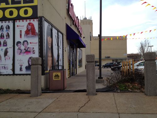
Retail at MLK & Kingshighway, one of many intersections where the right of way is curved, tight.
BRT for Kingshighway is a solution looking for a problem. The article states investing to improve the system. Tens of millions spent on BRT on the Kingshighway corridor wouldn’t improve the transit experience for those who currently use the #95 Kingshighway MetroBus. We shouldn’t spend big money just to make non-riders all warm & fuzzy inside unless it gets them to go car-free.
Right now if a weekday #95 bus travels the 11-mile 95/Kingshighway route northbound, just before 8am, it takes 56 minutes end to end. Driving the same route takes only 30 minutes. How much would each of the above BRT changes improve speed?
Since St. Louis doesn’t have any traffic congestion to speak of, having dedicated ROW or lanes wouldn’t make any substantial difference. Yes, the sub-mile Kingshighway between I-64 and Lindell gets a little backed up at times, but this less than a 10th of the route.
The biggest difference in this area between driving a car or taking the bus is the convoluted route the bus must take to reach the CWE Transit Center — connecting to other bus routes and light rail. The BRT could stay in the center of Kingshighway, but the 10-15 minute walk to connections would offset any gains elsewhere.
Off-board fare-collection is definitely a way to reduce boarding times. What does this mean? Currently bus riders enter a bus at the front door, paying their fare as the pass the farebox. Off-board fares are collected before allowing the rider onto the platform — a closed/turnstile system. If the fare is already paid then boarding passengers can enter via both doors, reducing dwell time.
Turnstile systems are more expensive and require more space than open platforms. Metro plans to retrofit existing light rail stations to require payment to enter. Unless fare gates are full height able-bodied riders can jump over the turnstile to avoid fare payment. The better alternative is simply to eliminate fares altogether.
Signal prioritization is effective, the bus communicates with a traffic signal to keep their light green for just a little longer. Reducing time spent siting at lights.
Platform height boarding reduces the time necessary for most passengers to board. Because of the horizontal gap, us wheelchair users still need more time to board. Light rail vehicles have a narrow enough gap that it’s not a problem. Higher platforms with turnstiles are more expensive than a regular bus stop. To save more time the number of stops is reduced, requiring some riders to walk farther to catch the bus compared to the existing bus.
Millions of dollars might reduce the total time from 56 minutes to 50 — easily offset by increased time walking on one or both ends of the trip.
My approach is to list problems and solutions:
Problem: #95 buses are often at capacity. Solution: use longer articulated buses like the ones used on the #70 Grand. Operate buses more frequently, also like the #70 Grand.
Boarding takes too long. Solution: stop accepting paper tickets & transfers. Require use of the Gateway Card for fare payment, or eliminate fares completely. Build raised platforms.
I’m not sure what problem(s) BRT is supposed to solve.
Graphic from November 2020 post showing area predicted to have population loss.
The 2020 Census results results for St. Louis showed what I had predicted, the bulk of our population loss came from northside wards. This was also true in 2010 and in 2020. No reason to think 2030 won’t be more of the same. We can sit back and do nothing, or we can help manage the situation — possibly reducing some losses in future.
By mange I mean see where population is dropping more than in other areas. We can’t just write of a third of our geographic area. I propose a group comprised of experts, residents, business owners, etc to examine data and evaluate possible solutions.
Here is some of the data I’d like to see on a big map(s):
Population by age & race
Parcels of land being used (water connection) vs unused.
Parcels of land with new or substantially renovated structures vs severally deteriorated, condemned, or vacant.
Parcels of land owned by the city, out of state owners, owner-occupied, LLC, .
Historic properties, sites.
Schools, current & former.
Employers and numbers of employees
Crime
Topography
Probably other criteria as well…
Since north city is not declining uniformly we need to see which parts that are doing better than others. Is this because 0f newer housing? Access to transit? All we know at this point is some blocks are stable and occupied while others are rapidly declining. Mapped data can tell us a lot, people on the ground familiar with their area can confirm or dispute what the data tells us. Get everyone on the same page, then reassess every few years and make adjustments as circumstances change for better or worse.
What we all need to accept is that it’s very unlikely these neighborhoods will see a major population growth. Ever. Thus some land can be returned to nature, used for agriculture, etc. The maps will show us the least populated areas with the worst housing stock — contrasted with pockets of denser areas with housing unlikely to be abandoned this decade. I’m not talking about large areas the size of Pruitt-Igoe, NGA-West, or Fairgrounds Park. It might be possible that smaller nature areas could be linked together by a trail system. A few great vacant school buildings not reused for residential might get filled with hydroponics to grow produce.
The major corridors like MLK, Page, Natural Bridge, Kingshighway, Grand, etc should remain. Many connecting streets would also remain. However, it’s possible in some areas we might be able to justify removing unoccupied streets and alleys. As St. Louis begins to look at replacing lead water supply lines those areas that’ll benefit most from the infrastructure investment should get priority over areas that can be back to nature by 2030. Old water & sewer lines might get abandoned completely in isolated areas.
The goal isn’t to cut off services to existing residents, but to use resources to strengthen and grow the existing strong pockets. On a block with say only one resident we can wait until that person moves or dies of old age. The children of longtime residents aren’t really interested in moving into the house their relative refused to leave. Conversely, a nice block with one newly-abandoned house needs help to make sure that one house gets maintenance and reoccupied as soon as possible. Quickly reoccupying a vacant building helps prevent others on the block from also being abandoned.
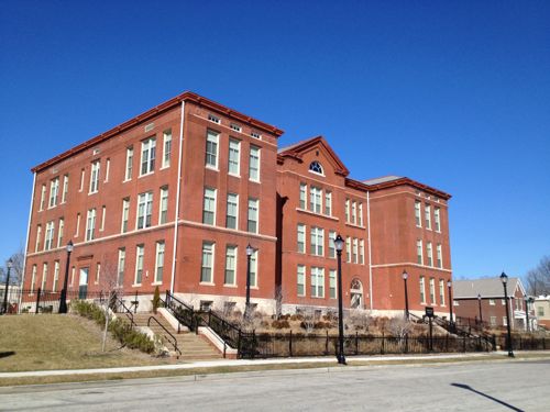
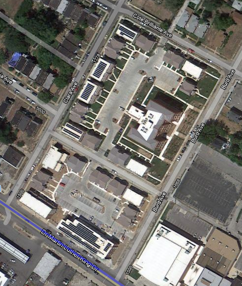
An example of a strong pocket would be MLK & Burd Ave. You’ve the Friendly Temple church and Arlington Grove housing (new housing around a renovated school that’s also housing). Substantial investment has been made, and this is home to many. We can reinforce the positives and look to expand upon that a block at a time.
Former Arlington School has been residential since 2013
Aerial after construction completed. Image: Google Maps
Just north of this pocket is a largely vacant area, part of the Wells-Goodfellow neighborhood that has gotten attention for mass demolitions. Other bright spots throughout north St. Louis include numerous tree-lined streets with well-maintained houses — it’s just hard for everyone to see & appreciate the them with so much decay. Whenever I see people wanting to raze vacant “problem” buildings I do get upset, because tearing down buildings in a random manner doesn’t improve neighborhoods for the long-term. It simply removes the current problem while likely speeding up others being abandoned as neighboring owners/residents die or move. By designating different areas for bright spot village and others as moving back toward nature we can reduce fights over razing vs preservation. I can even imagine a decent house in an area set to become nature/agriculture –it might be kept as basically a farmhouse. It wouldn’t necessarily be razed, just reimagined.
Along the way we can reevaluate I-70, an old interstate that winds its way through north city. Can we minimize this as a separating barrier in spots? Can we create areas for interstate drivers to pull off and get a bite to eat while their battery electric vehicle (BEV) charges?
One spot I see as the center of a future village is the intersection of Grand & North Florissant. That’s in part of 2 current neighborhoods, with a 3rd very close. It should be the very center of a thriving area.Why here? The intersection of two corridors should be treated as special. Both Grand and North Florissant are angled toward each other, so a person living or working here can pick either corridor to travel south — southeast on North Florissant or Southwest on Grand. Thanks to the odd street grid they have easy direct access to different parts of the city. Going northwest on North Florissant will eventually get them into St. Louis County.
By 2050 I see north St. Louis as being dotted with nice little villages, with nature in between. Primary corridors will be a line of density with restaurants, retail, offices, and multi-family housing. Rail &/or rubber tire public transit will connect these villages to each other and the larger city & region. I see walking & biking within and between villages. I see jobs growing produce outside and indoors, more jobs along the corridors. I see trees — thousands of them providing some relief from increased temperatures. The major corridors will be tree-lined, many new nature areas will become forests. I see all races, proportional to the mix in the population. Some villages, like The Ville, are predominantly black (75%, not 100%) with strong black-owned businesses. Again I’m talking 30 years, not 3.
What I don’t see are big surface parking lots for big box chain stores. I also don’t see blocks and blocks of obvious vacant residential buildings/lots.
St. Louis should use some of the money from the NFL to kick start the planning process to examine north St. Louis as I’ve described — taking stock and what we have (and don’t have) and then collectively finding solutions to change the trajectory. In the process others could come up with better ideas.
AARP Livibility Index
The Livability Index scores neighborhoods and communities across the U.S. for the services and amenities that impact your life the most
Built St. Louis
historic architecture of St. Louis, Missouri – mourning the losses, celebrating the survivors.
Geo St. Louis
a guide to geospatial data about the City of St. Louis