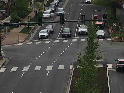
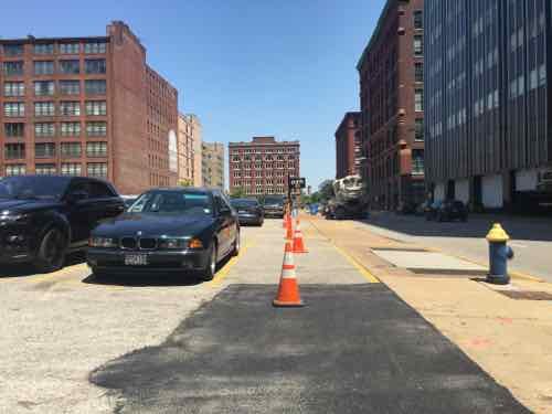
St. Louis has numerous places where, if you drive, you know the lanes shift left or right. The recent work to raise Forest Park Parkway/Ave up to be an at-grade intersection with Kingshighway added two more: WB Forest Park Ave at Euclid Ave and SB Kingshighway at Forest Park. The other day I photographed the former.
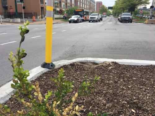
Looking East toward Forest Park & Euclid — All 3 lanes of Westbound traffic must shift top the right while crossing EuclidLooking East from the pedestrian refuge.The planter protecting pedestrians has been hit numerous times, the yellow markers have been added to make them more visible.
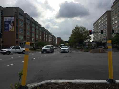
On numerous occasions I’ve been on the #10 MetroBus in the left-turn lane from SB Kingshighway onto EB Forest Park and I’ve seen cars in the center of the 3 SB Kingshighway lanes just continue straight — not shifting to the right. This puts them in the left most of 3 lanes. The problem occurs when a car is also in the left lane and shifts to the right to avoid hitting the pedestrian refuge planter — suddenly you have two vehicles wanting to occupy the same space. I’m rarely in either intersection as a motorist though I have driven both since the change was made.
I have experienced our car nearly being hit in a similar situation on EB Chippewa at Meramec. When traveling EB on Chippewa you have two EB lanes until just past Morganford Rd when only the left lane continues EB and the right lane goes off right to Meramec St. Again, on numerous occasions I’ve seen vehicles in the right lane just continue straight ahead — nearly hitting our car at least once. When I’m driving I’m aware this intersection is poorly designed — so I anticipate other drivers might not be aware of what is expected.
Back ar Forest Park and Kingshighway & Euclid the volume of cars is much higher. Both pedestrian refuge planters have been hit/damaged by vehicles. I suspect traffic accidents have been caused when a motorist doesn’t shift to the right — going straight ahead which means they’re changing lanes in the middle of an intersection.
Most drivers who regularly travel these routes will learn/remember to shift. It only takes one driver not paying attention or visitor to cause an accident or hit the planter and damage their vehicle.
How will future autonomous vehicles handle these shifts? We can and should do better in our street design!
In the late 1990s, Larry Deutsch was finally allowed to raze the historic 4-story building at 1101 Locust St. that housed Miss Hullings Cafeteria for decades. After the demolition crew left, new sidewalks were poured and the lot was covered in asphalt for surface parking. That’s when the line dividing private from public property was moved more than 3 feet. Legally the lot is 121 feet x 102 feet 6 inches. But by narrowing the public sidewalk, they made their lot 124.33′ x 105.83′ — a gain of 6%! This is roughly 750 square feet of public space that has been used privately for years.
This allowed them to have 5 additional parking spaces. The current daily rate is often $10, but let’s say $5/day. With about 300 revenue days a year, that’s $7,500 in additional revenue per year. Over 18 years the total estimate is $135,000. Serious money made by taking from the public right-of-way.
After my May 2016 post they put orange cones in the parking spaces that were partially on public property.
The building represents the property line, not the concrete sidewalk.
On the East end of 1101 Locust St the same thing along 11th — they [placed cones along the actual property lineEach time I’d go past the cones would be out — not as good as pouring new concrete sidewalks at the actual property line. But the other day I noticed they were back to stealing public right-of-way for their profits!
The driver’s half of this car is parked on the public right-of-wayAnd along 11th half of this vehicle is parked on the public right-of-way.
Ownership hasn’t changed. As I said two years ago, the city needs to force the Deutsch family to pour new concrete sidewalks that extend all the way to the property lin. They also need to bring this surface lot up to current standards for surface lots — with physical barriers between sidewalk & parking so cars can’t park on or drive on public sidewalks.
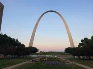
Looking toward the Arch from 4th Street, July 2014
Fifty-five years ago today “the first stainless steel triangle that formed the first section of the arch was set in place on the south leg” of the Gateway Arch. Demolition of 40 blocks of old buildings and original street grid of the original village of St. Louis had begun nearly a quarter century earlier — in 1939. The idea of completely erasing the riverfront and starting over began following the 1904 World’s Fair.
On April 11, 1934, lawyers filed incorporation papers for the new Jefferson National Expansion Memorial Association. Its charge was to develop “a suitable and permanent public memorial” to President Thomas Jefferson along the city’s dingy riverfront.
Its leader was Luther Ely Smith, who always seemed to be in the middle of noble endeavors. He would guide the riverfront project through Depression and war, a massive land-clearance and a top-flight design competition. He would be praised as the founding father when St. Louis selected as the suitable memorial Eero Saarinen’s idea for what would become the Gateway Arch. (Post Dispatch)
Luther Ely Smith (June 11, 1873 – April 2, 1951) didn’t live long enough to see the Arch even started, though he knew which design had been selected from the competition.
Not surprising St. Louis continues to honor people like Smith, someone who created a massive hole in the center of the city for decades. As chair of the City Planning Commission he hired Harland Bartholomew, who also pushed for massive destruction of the city & street grid — widening the remaining streets and opposing new rail transit. See Harland Bartholomew negatively impacted many cities.
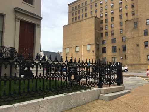
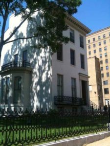
In the middle of the 19th century the mansions along Lucas Place, now Locust St, were considered way out on the edge of town.
Following the cholera epidemic and fire in 1849, wealthy citizens became convinced that it was no longer desirable to live in downtown St. Louis. James Lucas and his sister Anne Lucas Hunt soon offered a solution. They developed the idea of the “Place,” a neighborhood with deed restrictions that ensured it remained apart from the city and general population. The main thoroughfare was aptly called Lucas Place. Originally Lucas Place (now Locust Street) extended between 13th and 16th streets when the city limits were just one block to the west between 17th and 18th streets. When established, Lucas Place was west of the developed portion of the city, making it St. Louis’ first “suburban” neighborhood. (Campbell House Museum)
This 3-block oasis didn’t last long as St. Louis’ population exploded. The wealthy began to move Westward — this still happens in the region.One by one the grand old mansions became rooming houses and eventually razed for offices/warehouses.
Except one.
Built in 1851, the first house in the elegant Lucas Place neighborhood, the Campbell House was the home of renowned fur trader and entrepreneur Robert Campbell and his family from 1854 until 1938. The museum contains hundreds of original Campbell possessions including furniture, paintings, clothing, letters, carriages and a unique set of interior photographs taken in the mid-1880s. (Campbell House Museum)
More about the museum in a bit.
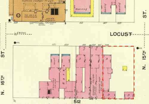
The Campbell House, lower right outlined in blue, was dramatically different by the time this Sanbon Map was made in February 1909. Click image to view source.
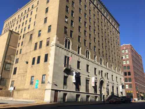
At this scale you can’t read that the abutting 24 foot wide lot includes a machine shop and garment factory. The next house West is still a residence but then we have a hotel and finally a printer. Across Locust St in the upper left is the Ely Walker Annex, and three old mansions turned into boarding houses. You’ll note the YMCA, closed in May 2017, hasn’t been built yet.
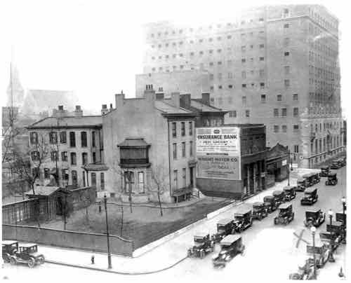
Last year the Campbell House Museum shared the following image as the YMCA was about to close. From their caption:
The YMCA is the last of the Campbell’s neighbors as Hugh and Hazlett Campbell were still alive for the first years of operation of the Downtown Y.
The photo dates from 1926 as the building nears completion. (Facebook)
This 1936 image shows the storefronts built in from of the mansion next door
After Robert & Virginia Campbell died their 3 sons continued living in the house until their deaths. Their youngest son died first, of the flu at age 30. The two older brothers lived into their 80s:
When Hugh died in 1931, Hazlett was declared of “unsound mind,” throwing into question the fate of the Campbell estate. While a lengthy court battle broke out among the Campbells various relations following Hazlett’s death in 1938, some St. Louisans were more concerned about the house and its contents. Through their efforts, the Campbell House Museum was formed, and soon managed to purchase most of the Campbell’s original effects. The Museum opened in 1943. (Campbell House Museum)
Yes, the Campbell House Museum is owned & operated by a private group — NOT the City of St. Louis. The museum opened on February 6, 1943 — 75 years ago tomorrow!
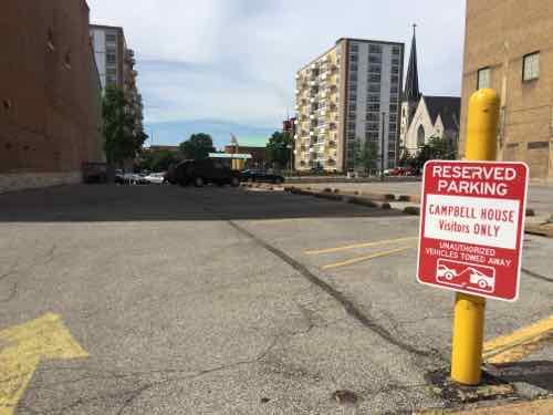
The space between the Campbell House Museum and the former YMCA has been surface parking since the 1940s. Despite what you might think, it isn’t one big lot for the Y. The 24′ wide lot next to the CHM is guest parking. They didn’t raze the building that was there — American General Insurance, now Terra Cotta lofts, used it for surface parking.
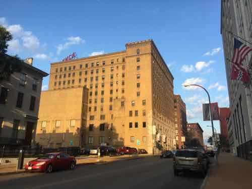
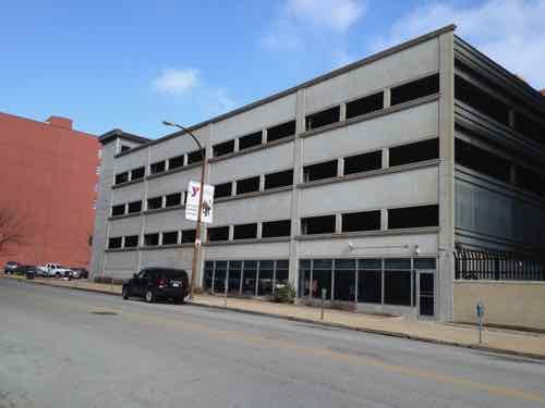
A sign indicates this narrow lot isn’t Y parkingIn this image you can see a little Campbell House on the left, the gap, and the East side of the former YMCA buildingA much closer viewThe upper floors of the YMCA were apartments, they’ve been vacant for any least a decade. The building is a 2-part condo: YMCA on the lower part, another owner for the upper floorsIdeally the gap would be filled in with something more active than a lifeless parking garage like the one across the street where the Ely Walker Annex once stood
The Campbell House Museum is planning new construction on the back of their narrow lot to construct an accessible entrance. At the front I’d like to see a building come within 5-10 feet of the CHM — with the same setback. In the rest of the gap I’d like to see infill step toward Locust — eventually meeting the sidewalk like the TMCA does. This building could be shallow to conceal a new parking garage at the rear of the lot.
I’d like all 3 automobile driveways in the gap area closed. A new garage can be accessed via the alley. Of course I want to see the former YMCA building renovated and occupied. It may take years, but it’ll happen. When it does I’m not so concerned about it as I am about the gap. It shouldn’t stay as surface parking, nor should it be another bland garage facing Locust. I would like to see the infill represent the best of 21st century design — in between 19th & 20th century buildings.
Again, tomorrow is the 75th anniversary of the opening of the Campbell House Museum. If you haven’t seen it I suggest you make an appointment or visit in March when regular hours resume.
Before the automobile public right-of-ways (PROW), public-owned land that connects private property, was shared by pedestrians, people on horseback, horse-drawn carriages, trollies pulled by horses, etc. PROW in cities were becoming increasingly crowded. Many roads were unpaved, those that were in cobblestones. Waste from horses & mules made the PROW filthy.
The new automobile made the PROW even more crowded. More than a century ago, a civil engineer in his late 20s arrived in St. Louis.
Harland Bartholomew (September 14, 1889 – December 2, 1989) was an American urban planner. Although a civil engineer by training and disposition, Harland’s career started just as the automobile production was about to take off, industrial development was booming and urban populations grew. The novel challenges and opportunities brought about by this new form of transport inspired the invention of new community concepts and required the development of new approaches to planning transportation in cities. These challenges called for the skills of an engineer to analyze transportation needs quantitiatively as well as those of a person passionate about urban design and social conditions. Harland was able to deliver these qualities. Starting in 1911 and continuing until 1930 Harland Bartholomew created new methodologies and new designs and concepts which made contributions that remain relevant to urban planning in North America today. This novel approach became known as comprehensive planning. His skills and experience were sought by many city planning commissions. Ultimately cities would develop their own in house technical staff to carry on with planning issues. Harland himself was the first full-time planner employed by an American city, and he remained a planner with St. Louis, Missouri for 37 years. During this period both the city of St. Louis and its surrounding areas were thriving and growing. Due to his groundbreaking work he can be described as the father of American and Canadian city planning in the age of the automobile. (Wikipedia)
Bartholomew, like his better-known contemporary, NYC’s Robert Moses, believed it was necessary to destroy the city to save it from itself. Everything prior to the 20th century was wrong for the modern world of the automobile.
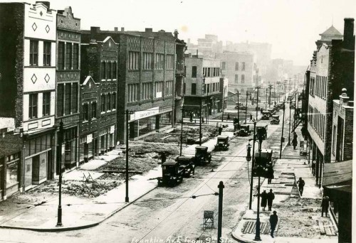
Franklin Ave looking East from 9th, 1928. Nothing in this image remains. Collection of the Landmarks Association of St Louis
Since 1916 St. Louis has expended over $40,000,000 in opening, widening, connecting, and extending the system of major streets. Much has been accomplished in converting a horse and buggy street system to automobile needs. As the total volume of traffic increases, however, certain new needs arise. An example is the desirability of grade separations at extremely heavy intersections, such as at Grand and Market and at Kingshighway and Lindell. Likewise there is a need for complete separation of grade where traffic volume is sufficiently heavy to justify the cost involved. The Federal Government, which has helped finance our splendid system of national highways, has recently revised its policies and Congress has appropriated substantial funds to aid the cities in the construction of express highways and for facilitation of traffic flows from certain selected state highways through metropolitan areas to the central business districts of large cities. Past and present experience reveals the need for four types of major streets and trafficways as follows:
Secondary Streets (4 Lanes) Most St. Louis streets were laid out with a width of 60 feet. A considerable volume of traffic can be accommodated in a 60-foot street with a 40-foot roadway, especially if curb parking is restricted at times of heavy traffic flow. Such streets as Nebraska, Compton, and Goodfellow can pr6bably continue for many years to accommodate a considerable volume of traffic flow without widening. All local residential areas require access and must be served either by wide major streets or by these secondary streets which thereby become important integral parts of the major street plan.
Major Streets (6 Lanes) Grand Avenue, Chippewa Street, and Easton Avenue are examples of important cross-town routes which accommo date a considerable volume of traffic including mass trans portation facilities (i.e., streetcars or buses). Their general width of 80 feet permits a 54 or 56 foot roadway to accom modate six lanes of traffic. There is need for quite a number of such routes where traffic volume is insufficient to warrantgreater width of the street except by expensive widening of the street.
Major Streets (8 Lanes) These are the main traffic ways, as for example Gravois Avenue, Market Street, Natural Bridge Road, Lindell Boulevard and Kingshighway. They are the dominant structural elements of the street plan. Their traffic capacity is unusually high since they permit three or four lanes of moving traffic in each direction. It is impractical to provide for streets with wider roadways because of weaving and complications encountered in traffic control.
Express Highways When traffic volume becomes so great that it cannot be accommodated even on eight lane surface highways it becomes necessary to provide for uninterrupted traffic flows through grade separations in the form of depressed roadways in wide right-of-ways or by roadway elevation. An overall right-of-way width of 200 feet is generally considered a minimum standard. This is far more costly than street widening but a limited mileage can be justified where there is sufficient traffic volume.
In today’s money that’s nearby a billion dollars! I’m uncertain if any city carried out the costly widening of the PROW the way St. Louis did. Based solely on my personal observations in other cities, I’d say St. Louis was the most aggressive. It’s no wonder that more than a quarter of those of voted in the recent non-scientific Sunday Poll have a problem with road diets.
Q: Agree or disagree: ‘Road Diet’ projects slow traffic too much, cause congestion; should be reversed.
Strongly agree 7 [18.42%]
Agree 0 [0%]
Somewhat agree 3 [7.89%]
Neither agree or disagree 3 [7.89%]
Somewhat disagree 1 [2.63%]
Disagree 8 [21.05%]
Strongly disagree 14 [36.84%]
Unsure/No Answer 2 [5.26%]
Sadly, our road diets have been designed to appease critics, so sidewalks new still too narrow — barely wide enough for existing for traffic. Motorists usually drive on typically wide Set. Louis area streets then encounter the “Great Streets” section for a brief period before returning to the more common Awful Streets of our region. We’re too timid to do more, so it can have a ater impact on population density, pedestrian/transit rates, etc.
Bartholomew also thought St. Louis’ population in 1970 would increase to 900,000 — it had dropped to 622k. Fingers are crossed we don’t drop below 300k in 2020. If St. Louis wants to grow again the entire region needs to reject the many ways Bartholomew screwed up our region.
AARP Livibility Index
The Livability Index scores neighborhoods and communities across the U.S. for the services and amenities that impact your life the most
Built St. Louis
historic architecture of St. Louis, Missouri – mourning the losses, celebrating the survivors.
Geo St. Louis
a guide to geospatial data about the City of St. Louis
 In the middle of the 19th century the mansions along Lucas Place, now Locust St, were considered way out on the edge of town.