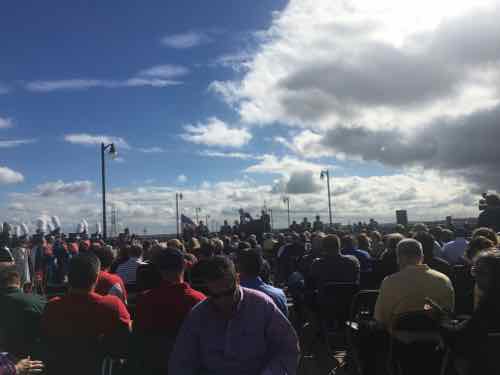
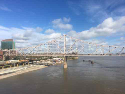
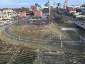
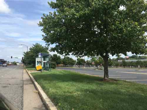
The recent non-scientific Sunday Poll was about the Eads Bridge,specifically the configuration of the top level.
Tere are the visuals from the poll:
Again, those voting were self-selected so the results aren’t scientific or representative of the regional mindset — just of 46 individuals. Still, these 46 do represent a small segment of the region — those interested in local infrastructure.
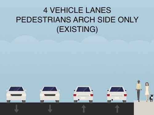
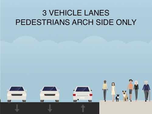
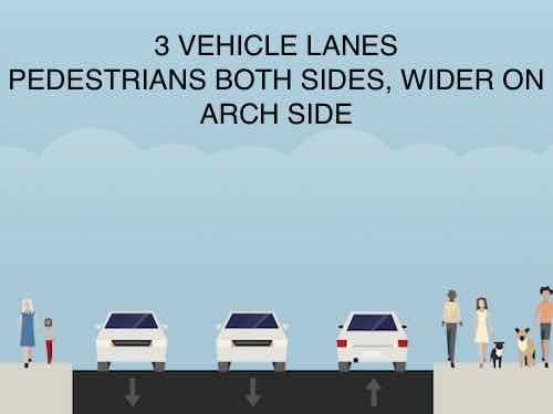
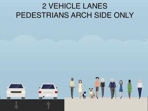
Q: How should the top of the Eads Bridge be configured in the future?
4 vehicle lanes, pedestrians Arch side only (existing) 12 [26.09%]
3 vehicle lanes, pedestrians Arch side only 5 [10.87%]
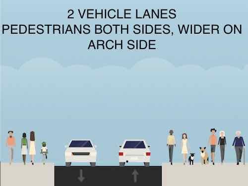
3 vehicle lanes, pedestrians both sides, wider on Arch side 5 [10.87%]
2 vehicle lanes, pedestrians Arch side only 3 [6.52%]
2 vehicle lanes, pedestrians both sides, wider on Arch side 14 [30.43%]
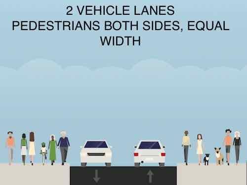
2 vehicle lanes, pedestrians both sides, equal width 3 [6.52%]
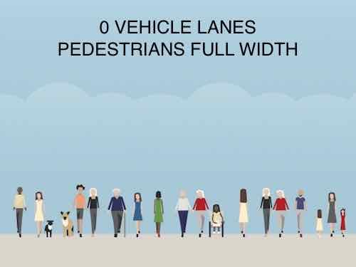
0 vehicle lanes, pedestrians full width 1 [2.17%]
Unsure/No Answer 3 [6.52%]
Just over a quarter supported the maximum number of vehicle lanes (4). A smaller number (21.74%) supported reducing driving lanes from 4 to 3. A whopping 43.47% voted to reduce vehicle lanes from the existing 4 to 2. Only one person (2.17%) voted to eliminate cars altogether.
I support the option that happened to receive the most votes: “2 vehicle lanes, pedestrians both sides, wider on Arch side.” Why?
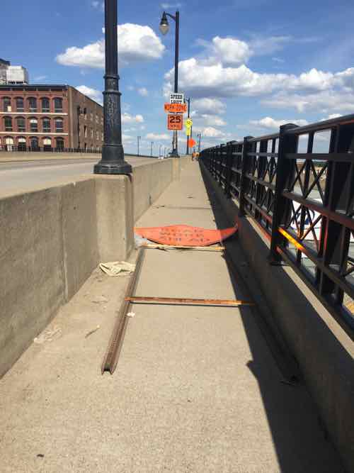
The pedestrian width is barely the minimum required while 4 vehicle lanes greatly exceeds demand. While I recognize the greatest pedestrian demand is on the Arch side, the North side is also interesting,
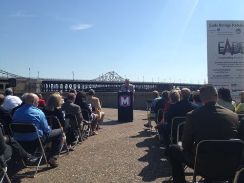
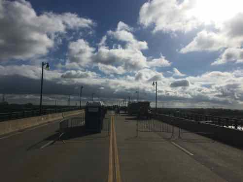
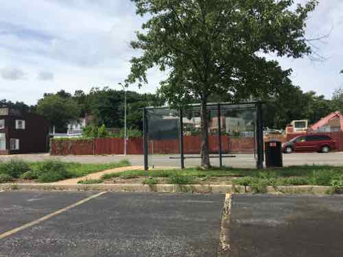
Metro Board Chair speaking at the Eads Bridge Rehabilitation Kick Off on May 22nd, 2012Metro & partners celebrating the completion of the restoration project on October 7, 2016I took this in June when a fallen sign in the narrow pedestrian path. I tried to tilt it to one side, but couldn’t. My chair was barely able to power over it.The 4 vehicle lanes were closed last month for the celebration, this much space isn’t needed for the volume of daily traffic.The views to the King Bridge, riverfront, Laclede’s Landing area to the North are all interesting — would love to be able to see & photograph on more than just special occasions.
So why not just make it all pedestrian? That would be as bad as it is currently, just in a different way. When driving, I like to use the Eads Bridge to cross the Mississippi River — it is the only non-interstate bridge crossing the river downtown.
If anything, I think it is worthwhile to examine the configuration of the top deck and see if a change should be made in the future.
7 In February I proposed putting a dedicated stadium in between Pine & Market, West of 20th
In the non-scientific Sunday Poll less than 10% of readers didn’t favor a dedicated soccer stadium, almost as many were undecided. Just over half picked near Union Station first with Grand & Chouteau 2nd.
Q: Which of the following represents your priorities with respect to a dedicated soccer stadium:
1) no dedicated soccer stadium 2) Grand/Chouteau 3) Near Union Station 3 [4.92%]
1) no dedicated soccer stadium 2) Near Union Station 3) Grand/Chouteau 3 [4.92%]
1) Grand/Chouteau 2) Near Union Station 3) no dedicated soccer stadium 16 [26.23%]
1) Grand/Chouteau 2) no dedicated soccer stadium 3) Near Union Station 0 [0%]
1) Near Union Station 2) Grand/Chouteau 3) no dedicated soccer stadium 31 [50.82%]
1) Near Union Station 2) no dedicated soccer stadium 3) Grand/Chouteau 4 [6.56%]
Unsure/No Answer 4 [6.56%]
Back in February 2016 I proposed a site near Union Station, see A Great Site For A Major League Soccer (MLS) Stadium In Downtown St. Louis. Regardless, I don’t think either ownership team or city leaders have the slightest clue about how to crete a quality pedestrian-friendly neighborhood. The Grand & Chouteau site should become a dense mixed-use neighborhood, but SLU is opposed to quality urbanism.
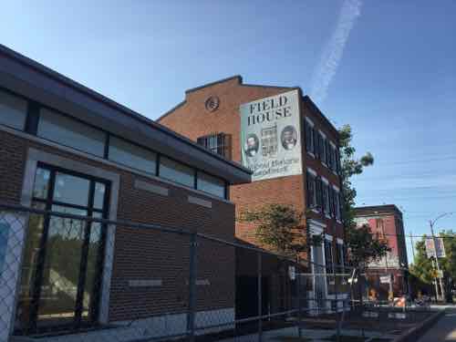
It was nearly two years ago when I saw the elevation drawing (below) for the proposed expansion of the 19th century Eugene Field House on South Broadway.
Initially my reaction was negative, I imagined cheap materials and poor detailing. However, I decided not to share my fears. I’m glad I didn’t.
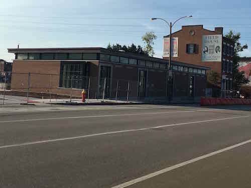
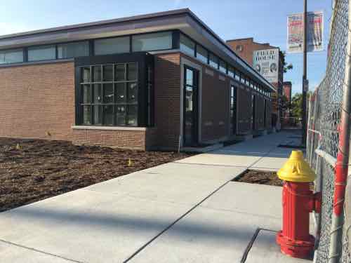
Yesterday I visited the site, still under construction, to see what I thought in person. First, we must know what used to be.
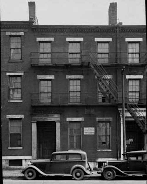
This 1920 photo shows houses on both sides. Source: unknown
In 1936 the other row houses were razed — leaving one out of context. The Eugene Field House & Toy Museum needed to create an accessible entrance. Given enough money, they could have recreated the block. But it wouldn’t have been authentic or met their needs.
On my way there I was prepared for the worst.
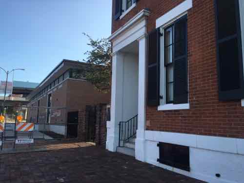
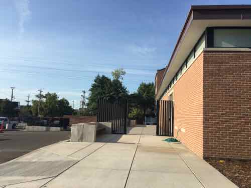
Even before crossing Broadway, I knew I liked it.The sole-survinving early 18th century row house with additionExcellent details include selective concrete/stone work, quality brick, black windows. The two are connected via a glass walkway set back from the street. This allows old & new to stand on their own merits.A beautiful box-bay window, reminiscent of those used in the 19th century, is prominently located at the NW corner.A sidewalk guides you from the front (West) to the entry that faces East.One of my favorite things is the visual extension of the foundation line on the North side of the parking lot driveway. It’s a small element, but it helps greatly in the separation of parked cars from pedestrian.
I couldn’t believe that I was liking what I was prepared to dislike. Once I saw the construction sign and the architect, my disbelief immediately vanished — I’ve known architect Dennis Tacchi for 25 years.
Let me be clear:
Razing the other non-significant row houses decades ago was a huge mistake.
Recreating the row house facades is something best left to Disney.
Broadway is a horrific pedestrian experience today.
An accessible entrance was needed.
I’m looking forward to the opening and seeing the interior. Now for some more history.
Located at 634 South Broadway, the three-story Greek Revival home was constructed in 1845. Originally it was one of twelve attached houses called “Walsh’s Row”. The other eleven buildings were demolished in 1936. The Eugene Field House became a City Landmark in 1971. It is known as the childhood home of the “Children’s poet” Eugene Field.
The Field House was designated a National Historic Landmark in 2007. (St. Louis)
In March of 1857, the United States Supreme Court, led by Chief Justice Roger B. Taney, declared that all blacks — slaves as well as free — were not and could never become citizens of the United States. The court also declared the 1820 Missouri Compromise unconstitutional, thus permiting slavery in all of the country’s territories. (PBS)
The row house at 634 S. Broadway had two significant occupants, but it’s the entire block that should have been saved. Eighty years ago a bad decision was made, we must make the best of it today. This is a tiny step in the right direction.
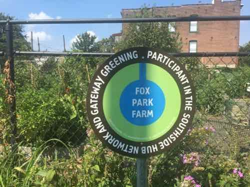
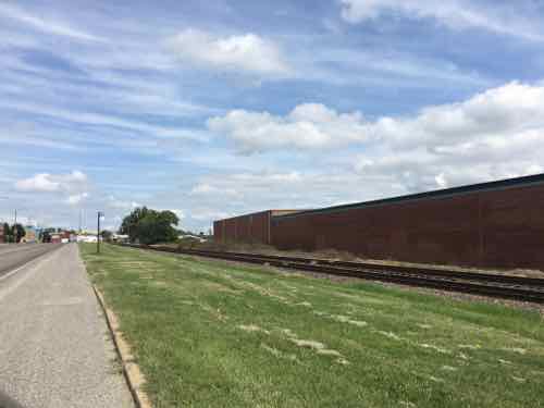
Fox Park Farm is now of many community gardens in St. Louis
The recent Sunday Poll was actually two polls, both n0n-scientific. First, the questions and votes:
#1: Which of the following, if any, should residents be allowed to raise in the city? Animals would be subject to minimum space requirements. (Check all that apply)
Chickens 29 [24.17%]
Rabbits 26 [21.67%]
Goats 15 [12.5%]
Sheep 10 [8.33%]
Alpacas 9 [7.5%]
None should be allowed 8 [6.67%]
TIE 6 [5%]
Emus
Ostriches
Dairy Cows
Pigs 4 [3.33%]
Unsure/no opinion 1 [0.83%]
#2: Agree or disagree: With so much vacant land in the city, much more land should be used for urban food production
Strongly agree 16 [44.44%]
Agree 7 [19.44%]
Somewhat agree 8 [22.22%]
Neither agree or disagree 1 [2.78%]
Somewhat disagree 1 [2.78%]
Disagree 0 [0%]
Strongly disagree 3 ]8.33%]
Unsure/No Answer 0 [0%]
I think it’s fair to say among readers there is general support for some farm animal and increased agriculture. For a few years now I’ve been seeing stories about new suburban subdivisions with a farm in the center instead of a golf course:
From 2013:
There’s a new model springing up across the country that taps into the local food movement: Farms — complete with livestock, vegetables and fruit trees — are serving as the latest suburban amenity.
It’s called development-supported agriculture, a more intimate version of community-supported agriculture — a farm-share program commonly known as CSA. In planning a new neighborhood, a developer includes some form of food production — a farm, community garden, orchard, livestock operation, edible park — that is meant to draw in new buyers, increase values and stitch neighbors together. (NPR: Forget Golf Courses: Subdivisions Draw Residents With Farms)
From 2015:
The phrase “planned community” conjures up a lot of images — maybe a swimming pool, obsessively manicured lawns, white picket fences — but a farm is probably not one of them.
Pushing back against that stereotypical image of suburban living is a growing number of so-called “agrihoods” springing up nationwide. These developments center around a real, functional farm as their crown jewel. According to CivilEats, there are currently about 200 of them nationwide.
The latest, called The Cannery, officially opened this past Saturday on a site that was previously home to a tomato cannery facility located about a mile outside downtown Davis, California. The 100-acre project of the New Home Company development company is considered to be the first agrihood to take root on formerly industrial land. All of its 547 energy-efficient homes will be solar-powered and electric car-ready, KCRA, NBC’s Sacramento affiliate, reports. (Huffington Post: ‘Agrihoods’ Offer Suburban Living Built Around Community Farms, Not Golf Courses)
This CBS News story was recently repeated on CBS’ Sunday Morning. So this story and taking a survey on urban food production in the city got me thinking: must the “agrihood” movement be limited to very expensive suburban developments? I could see an agrihood being part of the development of the near north side. In an agrihood, the farm is professionally run. It’s not a community garden run my neighbors. It could be a way to create jobs for area youth. I’d want housing to be a different price points and not displace current residents.
We have more land than we’ll likely ever have residents to fill. For years, in cities coast to coast, people have been farming on vacant urban land. St. Louis is no exception — see RFT’s 10 Local Urban Farms We Love.
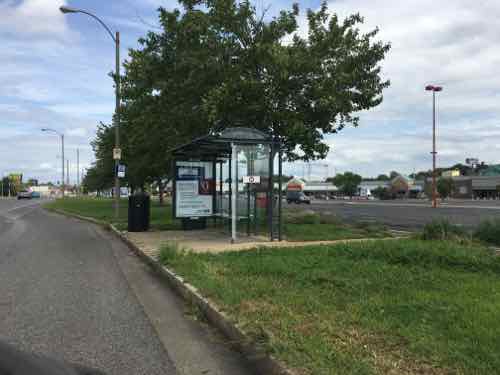
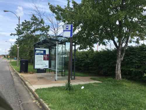
Part of the implied contract when taking a bus to a destination is when you’re dropped off at your stop, you’ll be able to get to the corresponding stop in the opposite direction for the return trip. Seems simple enough, right? But in many parts of the St. Louis region being able to reach a bus stop in the opposite direction is impossible if you’re disabled. I don’t go looking for them, I run across them just going about my life.
Since the Americans with Disabilities Act of 1990 became law, transit operators, like Metro St. Louis, formerly Bi-State Development Agency, have equipped their fleet of buses with either a lift or ramp in new low-floor models. This permits those us who use wheelchairs to board every bus with access to hundreds of routes throughout the region — theoretically, at least. Bus routes are operated on municipal/county roads throughout our region. The responsibility for these public rights-of-way (PROW) are that of the municipality, county, or state — depending upon the entity that has assumed responsibility. Regardless, the transit agency generally isn’t responsible for the pedestrian infrastructure (sidewalks, curb cuts. etc) to/from their bus stops.
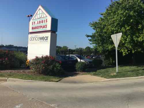
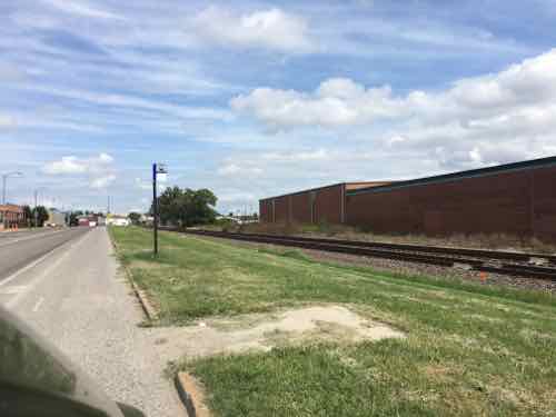
Today’s example involves a 2.5 mile stretch of Manchester Ave from McCausland Ave to Kingshighway Blvd — all in the City of St. Louis. A third of this stretch is fronted by the St. Louis Marketplace — a strip retail center that opened in 1992 — it was St. Louis’ very first TIF project. A former industrial area was reclaimed for retail by relocating railroad tracks further away from Manchester. The entire site was new from scratch and post-ADA. Furthermore, Manchester Ave has had a bus route for the entire 26 years I’ve lived in St. Louis — probably for at least 3-4 decades. For years it was the #59, but after the Cross County MetroLink line opened in 2006 the #59 stops at Maplewood and the #32 was extended West to Maplewood.
The morning of August 11th my husband forgot his phone, so I decided to take it to him. His morning client lives a few blocks North of Manchester Ave. in the Franz Park neighborhood (aka Dogtown), 24th ward. With my car key I was able to leave his phone in the door pocket and a note on the seat. I needed to return to Manchester Ave and catch the #32 Eastbound.
I crossed Manchester at the light at Prather Ave, Google maps told me the stop was to the right. Thankfully ramps were built.Looking West toward the bus stopThankfully my chair had enough power to roll over the grass. If it had been wet or muddy I couldn’t have reached this bus stop . A user of a manual chair probably couldn’t have. and finally, why should ab;e-bodied pedestrians have to walk through grass? The bus stop sign is attached to the light post.
When I boarded the bus from this stop the driver asked me how I managed to get to the stop! On the bus I noticed a stop further East that I’ve blogged about before.
A bench head been casually placed at the stop, partially blocking the pad that was barely big enough for a wheelchair user to turn around.
I paid attention to all the stops as we passed each one. I decided I needed to look at the entire stretch, not just one stop here or there. Again, the distance between Kingshighway and McCausland is 2.5 miles. There are 12 MetroBus stops in each direction. All 12 in the Westbound direction are accessible — not ideal but adequate. However, in the Eastbound direction only half are accessible/adequate.
Six aren’t accessible, although I was able to power through the grass to reach one of them. Four of these six inaccessible bus stops are in front of the St. Louis Marketplace, the retail development that was created 100% from scratch after the ADA became law. Let’s take a look.
Starting at Ecoff Ave on the West edge of St. Louis Marketplace, you can see the curb ramp in the lower right corner but it leads to grass not sidewalkMy guess is either the city or developer were supposed to add a sidewalkThis is the stop I used on August 11thThe next EB stop has a place for the bus to pull over and a shelter — the city & Metro planned ahead for this stopThe back side shows a curb prevents access from the parking lotThe next stop also has a space for the bus and a shelter, but no sidewalk along ManchesterThis looks accessible. right?Like the previous stop, a curb prevents access from the parking lotThe last of the four stops in front of the shopping center also has a shelter. Here you can see concrete was recently added — the old walkway next to the shelter was too narrow to meet the ADA minimum.Oh yes, it’s wide enough now, But no sidewalk leading to the bus shelter and shrubs are at the backCharter vans blocked my view of the walkway but it’s safe to assume it has a curb like the two previous stops.The next stop East of the shopping center isn’t accessible at allBut yes, Metro added a wheelchair pad in a recent round of ADA improvements. I guess we’re expected to cross Manchester between signals to reach this stop? If I’m heading EB would a driver let me off at this stop? Anyone using this stop risks getting hit crossing Manchester.The bench that was blocking the stop at Hampton was moved after I tweeted about it, but seating is needed — just not blocking the pad.And the 6th inaccessible stop is just East of MacklindMetro also poured a pad here even though there’s no safe way to reach it.
Previous posts on a couple of bus stops on this stretch of Manchester:
AARP Livibility Index
The Livability Index scores neighborhoods and communities across the U.S. for the services and amenities that impact your life the most
Built St. Louis
historic architecture of St. Louis, Missouri – mourning the losses, celebrating the survivors.
Geo St. Louis
a guide to geospatial data about the City of St. Louis