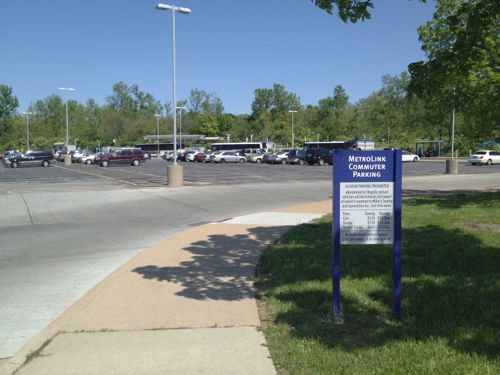
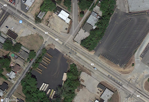
The Rock Road MetroLink station was designed in the early 1990s as a drive-to station with 183 parking spaces. For twenty years now pedestrians have endured horrible conditions to reach the train platforms and MetroBus lines.
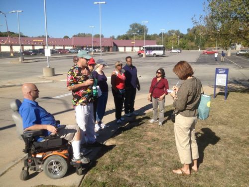
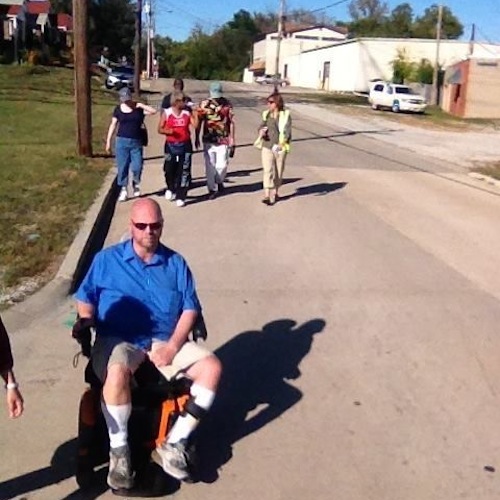
On Sunday I joined a Citizens for Modern Transit (CMT) Ten Toes walking group as it did a walk audit in the neighborhood to the south.
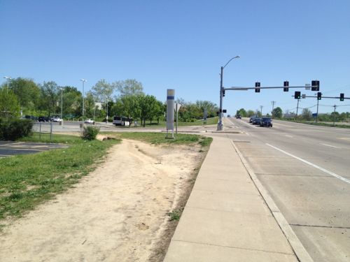
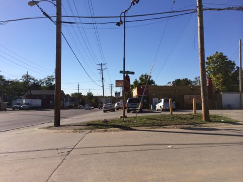
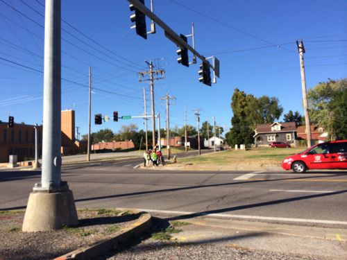
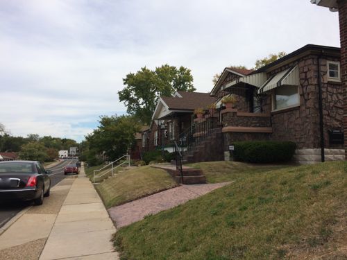
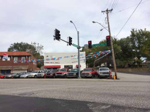
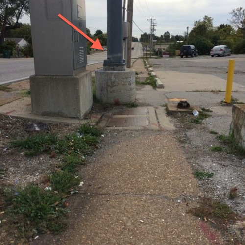
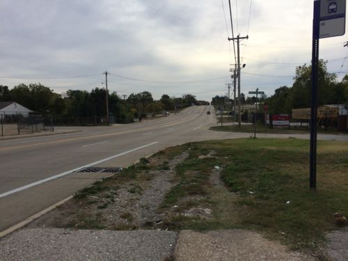
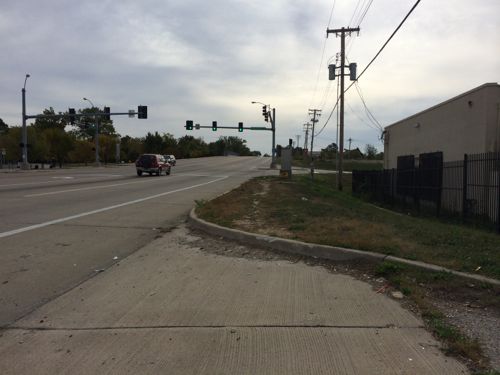
We started at the ticket machines, our first stop was the entry point. Half did a straight shot through the parking lot, the rest of us went the long way on the sidewalk. Photo: CMTIn April 2012 I noted: The parking was placed between the entry off St. Charles Rock Rd. and the station itself, pedestrians must either go out of their way to stay on the sidewalk or schlep through the parking lot. Click image to view April 2012 post on the Wellston & Rock Road stationsApproaching from the west pedestrians have worn a strong path to reach the station. April 2012We went south on Kingsland to Page, most of the way we had to use the road since no sidewalks exist. Photo CMTAt Page we headed west to Ferguson, click image for mapAt Ferguson I had to split off since I forgot to charge my chair the night before. I caught a #94 back downtown. Click image for map.Ferguson surprised me with cute houses and a decent, but narrow, sidewalk. The only issue is many people park on the curb. St. Charles Rock Road can be seen at the end of FergusonWhen you reach St. Charles Rock Road there’s no easy or safe way to cross to the north side. So I decided to stay on the south side and cross at the entry to the station. Click image for map.I was in the upper left and had to get to the lower right to cross the street and enter the station property.My destination is marked by the red arrow, but traveling the short distance looks problematic20 years of pedestrians have worn a pathI had to use the shoulder because my chair can’t jump curbs, a worn path is visible.
Again, it baffles me that we could spend hundreds of millions to build transit infrastructure and, after two decades, not do what it takes to make it accessible nearby to pedestrians. No wonder we’ve not seen any new development around this busy station.
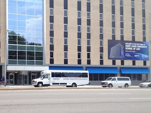
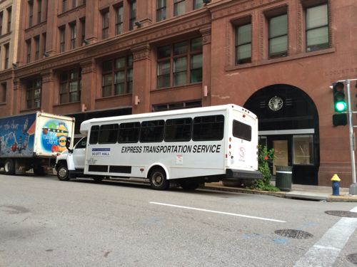
One reason for trying to build the St. Louis Streetcar is to reduce the number of polluting buses on the streets, in particular, from shuttles for the new Saint Louis University School of Law (my review of the building). The law school is open and the diesel-powered shuttles are very visible.
Shuttle in front of Scott HallShuttle idling on Locust at 9th, near Culinaria
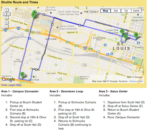
Here’s a quick summary of the route:
Scott Hall Shuttle You can access Scott Hall from the main university and designated law school parking via a new shuttle. Hours and information can be found here. The shuttle will connect Scott Hall to the main University campus, Salus Center and the law school parking at Schnucks Culnaria and 1215 Olive St. surface lot. The final shuttle runs from Scott Hall at 10:10 p.m. with drop-offs at Culinaria, the 1215 parking lot and finally at Busch Student Center. (source)
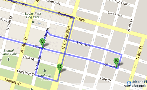
And here’s visuals:
Scott Hall Shuttle route map on SLU websiteClose up of the route in the central business district
Seems excessive too me, especially when they sit and idle, spewing diesel fumes. Guess law students won’t mix with the general public with such an elaborate shuttle system at their disposal. Presumably, though, amy SLU faculty, staff, or student, can ride it.
Metro transit customers asked for newer technology to help them track MetroBus arrival times and now it is here. When Proposition A passed, Metro promised to use those funds to build a better transit experience. The first phase of technology advances to keep MetroBus customers better informed about bus stop arrivals is now available on www.metrostlouis.org.
“We are really excited to be able to bring this new technology to our customers, but we won’t stop there,” said Ray Friem, Metro Chief Operating Officer Transit. “In the next year, we hope to roll out the cell phone application. That will mean you can stand at your bus stop, punch in the stop number on your smart phone and find out when to expect your bus.”
Here’s how the new online technology works. Go to the Metro website, look for the Plan Your Trip area near the top right of the screen and select Metro Trip Planner. Then there are two choices. 1. Use the left side of the screen to use trip planner the way you always have, or 2. Use the map to click on your departure location. A box will appear and allow you to click on “Find nearby stops.” From there you can:
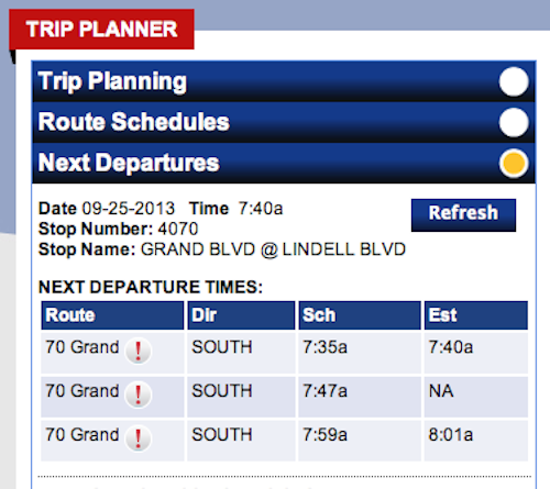
• Click on the yellow or blue circle where you want to catch the bus. Yellow circles show “time points.” Operators do not leave early from a time point. The blue circle shows a regular bus stop. Please remember to arrive at your stop at least five minutes early. Depending on traffic conditions, a bus may arrive and leave early from a bus stop that is not a time point. After you have selected your preferred stop: • Click on “Get next departures.” Included in the information box is the route, the direction (Dir), scheduled arrival time (Sch) and estimated arrival time (Est) if the estimated arrival time is available. • The majority of our MetroBus vehicles are now equipped with automatic vehicle location devices (AVL) and that allows us to track where the buses are at all times. Eventually, AVLs will be installed on every vehicle in our MetroBus fleet. If the MetroBus vehicle that is headed to your stop is AVL equipped, the Estimated Arrival column will show a time. When you compare Scheduled Time (Sch) to the Estimated time (Est) you will know if the bus is running early, on time or behind schedule. • If the MetroBus does not yet have AVL, then the Estimated Arrival column will display ‘NA’ for “not available.” Customers who need assistance planning their trips, may call 314-231-2345 in Missouri or 618-271-2345 in Illinois Monday through Friday from 7:30 a.m. to 4:30 p.m.
The site is easy to use at home/work on a computer, laptop, or tablet. No mobile optimized site or app yet.
Example of scheduled versus estimated times, click image for Metro’s Trip Planner
It is easiest to look up times based on a bus stop number, so I’ve made note of the stop numbers near me at 16th @ Olive:
Eastbound (South): #15146
Westbound (North): #2605
To go west on the #10 I want Metro’s northbound route. Sounds confusing but it makes sense when you look at the route map. I still need to look up a few others on Washington and on 14th.
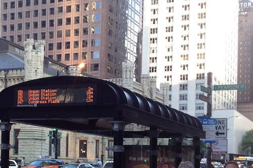
Eventually Metro will have the technology in place to show time until the next few buses, like this example from Chicago.
Once the information is available at shelters I’ll be really excited. I’m very glad Metro is making progress.
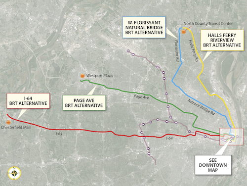
In the poll last week, readers preferred the proposed Bus Rapid Transit (BRT) route going out I-64 to Chesterfield. There was no clear preference among the other three options for a second choice to submit to federal authorities for a funding request. As I mentioned in my original post, here are the four routes being studied:
These four potential BRT routes are options for improving transit connections between St. Louis County and the City of St. Louis. One of the study’s main goals is to address the need for quick, direct travel from neighborhoods north and south of Downtown St. Louis to employers located in north and west St. Louis County. The “Central Corridor” stretching from Downtown St. Louis to the Central West End and Clayton still holds the region’s largest concentration of jobs, but the largest job growth is occurring in places like Chesterfield, Earth City, and St. Charles – areas easily accessible by highway, but currently not by public transit. The type of BRT service currently being studied is intended to expand access and improve travel time to those job opportunities – of particular importance to reverse commuters traveling to major job centers in suburban areas – while also providing a premium transit alternative for car commuters. The Rapid Transit Connector Study will identify candidates for Metro’s first two BRT routes; Metro will continue to work with the region to identify future BRT routes. Other transit options identified in Moving Transit Forward, such as expansions of the MetroLink System, are intended to meet other long-term goals such as strengthening neighborhoods and encouraging transit-oriented development. Alternatives analysis involves evaluating the performance of each alternative along parameters including ridership, expanded access to key destinations, travel time savings, and land use benefits. These technical outcomes will be combined with public input to identify the two potential projects most likely to meet project goals, benefit the region, and successfully compete for federal funding.
Four alternative BRT routes, click image to view larger version
Here are the results from last week’s poll:
Q: Which two of the four Bus Rapid Transit (BRT) routes would you like to see planners seek federal funding (pick 2)
I-64 Highway BRT 27 [31.03%]
None 17 [19.54%]
West Florissant-Natural Bridge BRT 16 [18.39%]
Page Avenue BRT 16 [18.39%]
Halls-Ferry Riverview BRT 8 [9.2%]
Unsure/no opinion 3 [3.45%]
I like the idea of a Bus Rapid Transit route to Chesterfield, but I wonder if terminating the route at Chesterfield Mall is best. At this moment there’s interest in the two new outlet malls in the Chesterfield valley, but it’s unclear to me if the valley or mall is a better terminus point. I’d like to know the logic behind this decision, likely because it would serve more people.
The Halls-Ferry Riverview route received half as many votes as the West Florissant-Natural Bridge & Page Ave routes. I like both of these routes, they both side through parts of St. Louis that could benefit from improved transit.
My guess is the I-64 & West Florissant-Natural Bridge & Page routes will be the two selected for submission for federal funding. Two routes would have a stop one block away, another 5 blocks away, and Halls-Ferry route 11 blocks east. I’m in a good place, but I want to make sure any investment in new infrastructure serves an accepting public. I know city residents will go to Chesterfield for work, but will Chesterfield residents take a bus, albeit a nice bus, into the city rather than drive? I certainly hope so!
Last week regional transportation planners presented four Bus Rapid Transit (BRT) being considered. Soon two will be picked to submit for federal funding.
Four alternative BRT routes, click image to view larger version
I attended the presentation at City Hall and participated in the audience voting using hand held devices. They asked a couple of questions to help them in their decision. To keep things simple I’m just asking which two of the four BRT routes should move forward with a request for federal funding.
These four potential BRT routes are options for improving transit connections between St. Louis County and the City of St. Louis. One of the study’s main goals is to address the need for quick, direct travel from neighborhoods north and south of Downtown St. Louis to employers located in north and west St. Louis County. The “Central Corridor” stretching from Downtown St. Louis to the Central West End and Clayton still holds the region’s largest concentration of jobs, but the largest job growth is occurring in places like Chesterfield, Earth City, and St. Charles – areas easily accessible by highway, but currently not by public transit. The type of BRT service currently being studied is intended to expand access and improve travel time to those job opportunities – of particular importance to reverse commuters traveling to major job centers in suburban areas – while also providing a premium transit alternative for car commuters. The Rapid Transit Connector Study will identify candidates for Metro’s first two BRT routes; Metro will continue to work with the region to identify future BRT routes. Other transit options identified in Moving Transit Forward, such as expansions of the MetroLink System, are intended to meet other long-term goals such as strengthening neighborhoods and encouraging transit-oriented development. Alternatives analysis involves evaluating the performance of each alternative along parameters including ridership, expanded access to key destinations, travel time savings, and land use benefits. These technical outcomes will be combined with public input to identify the two potential projects most likely to meet project goals, benefit the region, and successfully compete for federal funding.
You may not like any of the four, however, I’ve not allowed any custom answers so you can’t suggest any other routes. These four need to be narrowed to two. I did provide “none” as an option as well as “unsure/no answer.” The poll is in the right sidebar (desktop layout).
AARP Livibility Index
The Livability Index scores neighborhoods and communities across the U.S. for the services and amenities that impact your life the most
Built St. Louis
historic architecture of St. Louis, Missouri – mourning the losses, celebrating the survivors.
Geo St. Louis
a guide to geospatial data about the City of St. Louis