Home » Public Transit » Recent Articles:

Readers Lean Toward Expanding Proposed Modern Streetcar Line With Connections To MetroLink Light Rail

The poll last week had two related questions, basically how you’d expand the proposed streetcar through north & south city, respectively.

North:

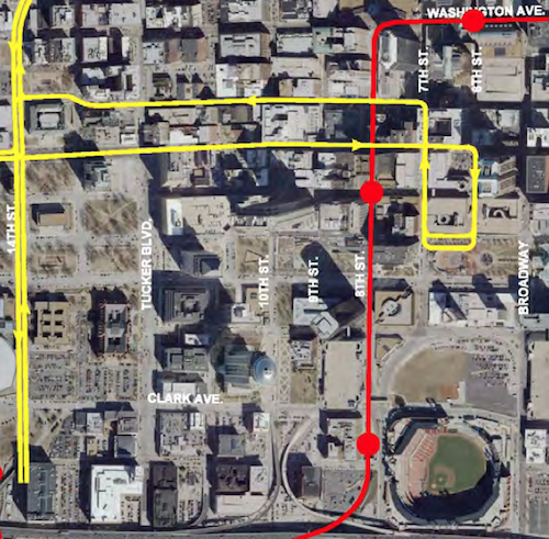
Poll #1/2: From the options below, select how you’d extend the proposed streetcar line further into north city from N. Florissant & St. Louis Ave:

  1. N. Florissant>Natural Bridge>UMSL South MetroLink Station 14 [26.42%]
  2. None, I’d prefer light rail over modern streetcar 8 [15.09%]
  3. None of the above, don’t extend at all 7 [13.21%]
  4. Better to expand north from Lindell @ Taylor 7 [13.21%]
  5. Cass>MLK/St. Charles Rock Rd>St. Charles Rock Rd MetroLink Station 4 [7.55%]
  6. Unsure/No Answer 4 [7.55%]
  7. None, I’d take a route not listed 3 [5.66%]
  8. Won’t be anything to extend 3 [5.66%]
  9. St. Louis Ave>Goodfellow 2 [3.77%]
  10. N. Florissant>Goodfellow 1 [1.89%]

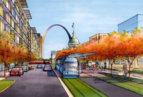
The option that was, at least partially, selected for a north extension of our light rail received the highest number of votes, though hardly a consensus. In that plan the light rail turned north at Goodfellow, whereas I proposed continuing west to UMSL. This would be about a 7 mile extension, perhaps built in 1-3 phases. Natural Bridge is excessively wide so the streetcar could run in a median, just as was planned with the light rail.  Nearly the entire route is suitable for densification without displacement. This could bring much needed jobs as well as new housing options.

Looking east on Natural Bridge at Newstead, March 2012

This alignment would replace the current #4 (Natural Bridge) MetroBus route. Current frequencies range from 27 minutes to one hour, depending upon the time of day.

Some possible future expansions for the proposed streetcar line ending at N. Florissant @ St. Louis Ave
The teal route along Natural Bridge received the most votes of any one answer

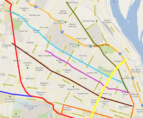
UMSL is working on a plan to improve Natural Bridge, better connecting to the UMSL South MetroLink light rail station. A modern streetcar could be a great connection, helping deal with that first/last mile to/from light rail.

South:

Poll #2/2: From the options below, select how you’d extend the proposed streetcar line into south city from 14th & Spruce:

  1. 14th/Spruce> Chouteau> Jefferson> Chippewa> Lansdowne> Shrewsbury MetroLink Station 15 [28.3%]
  2. 14th/Spruce> Lafayette> Tucker> Gravois> Hampton 13 [24.53%]
  3. 14th/Spruce> Chouteau> Vandeventer> Southwest> Hampton 7 [13.21%]
  4. None, I’d prefer light rail over modern streetcar 5 [9.43%]
  5. 14th/Spruce> Chouteau> Broadway > River Des Peres 3 [5.66%]
  6. Other: 3 [5.66%]
  7. None, I’d take a route not listed 2 [3.77%]
  8. Won’t be anything to extend 2 [3.77%]
  9. Better to expand south from Forest Park @ Taylor 2 [3.77%]
  10. None of these, don’t extend at all 1 [1.89%]
  11. Unsure/No Answer 0 [0%]

Three readers provided their owner answers to this question:

  1. I’d like to see the route follow Jefferson, but continue south on Broadway
  2. 14th/Spruce>Gravois>Jefferson
  3. think about the goals of the whole system first

Like The goals for a streetcar go beyond just transit, they include:

  • Creating dense corridors.
  • Spurring new construction, creating construction & permanent jobs.

Looking at the votes here it looks like readers would prefer the south alignment to get into the heart of the southside rather than stay closet to Broadway/I-55. If we were to build the planned light rail instead it would go down Jefferson to Broadway and terminate in a park- & ride lot at I-55, with further expansion along the I-55 ROW into South County.

Some possible future expansions for the proposed streetcar line south from 14th @ Clark
The teal route along Jefferson & Chippewa received the most votes, though the pink route wasn’t far behind.

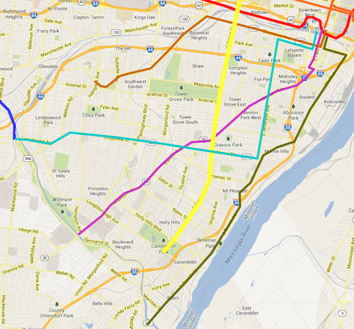
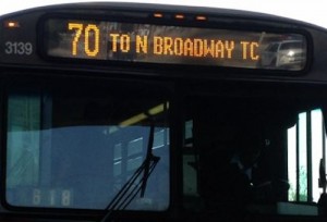
The south streetcar alignment that received the most votes would replace the current #11 (Chippewa) MetroBus which does a big “L” by traveling on Jefferson (north-south) and Chippewa (east-west). This would intersect with many existing bus routes, including the very busy #70 (Grand).

Right behind in votes was an alignment that would replace the rest of the #10 (Gravois-Lindell) MetroBus. Part of this bus route would be replaced by the original streetcar route on Olive/Lindell. Going down Gravois would cut through a big section of south city, connecting with east-west & north-south buses.

Thoughts?

— Steve Patterson


Polls: How Would You Expand Modern Streetcar Lines From Proposed Route Into North & South City?

I’m excited about the proposed St. Louis Streetcar, I’m a streetcar fan and the idea of living just a block away from the line has be overjoyed. Like out 20 year old light rail line, the streetcar primarily serves the city’s central corridor — downtown and parts west. North & south St. Louis wouldn’t benefit with the original route. I’ve lived 16 of my 23 years in St. Louis in north (3) and south (13) city, I know what it’s like to see millions spent on transit infrastructure with little personal benefit.

Even living downtown now I use MetroBus way more often than MetroLink, the bus is closer to me and my frequent destinations than light rail.

For the purposes of this post/poll I’ve made the following assumptions:

  • The initial streetcar line will open in 2017, aligned as proposed. 
  • The #70 MetroBus line on Grand will get longer articulated buses.
  • In-street light rail to quickly get north & south county suburbanites to ballgames won’t move forward
  • Modern streetcars are as much about economic development as transportation.

The poll this week is broken into two questions: 1) how would you expand the proposed streetcar line further into north St. Louis from the spur at N. Florissant @ St. Louis Ave. and 2) how would you expand the proposed streetcar into south St. Louis from 14th @ Clark.

Some possible  future expansions for the proposed streetcar line ending at N. Florissant @ St. Louis Ave
Some possible future expansions for the proposed streetcar line ending at N. Florissant @ St. Louis Ave. Grand is shown in yellow.

The north options I’ve listed in the poll are:

  • Cass to MLK to the St. Charles Rock Rd MetroLink station. This goes though areas in need of development, investment, & jobs, but doesn’t go very far north
  • West on St. Louis Ave to Goodfellow. This goes through areas also needing the above but runs through primarily residential areas while crossing major commercial streets.
  • N. Florissant to Natural Bridge, eventually out to UMSL south MetroLink. Natural Bridge is a wide right-of-way, plenty of room for a streetcar in the center.
  • N. Florissant past the cemeteries to Goodfellow. This goes farther north than the other options, possible connections to north county bus/streetcar
Some possible future expansions for the proposed streetcar line south from 14th @ Clark
Some possible future expansions for the proposed streetcar line south from 14th @ Clark. Grand is shown in yellow.

The south options listed all start by going south on 14th from Clark:

  • Chouteau to Broadway to River Des Peres
  • Chouteau to Jefferson to Chippewa to Lansdowne to Shrewsbury MetroLink
  • Lafayette to Tucker to Gravois to Hampton
  • Chouteau to Vandeventer to Southwest to Hampton

Poll questions for both north & south are in the right sidebar. As you can see these vary and cover different parts of the city. Variations in the street network between north & south city plays a role as well.

Please share your ideas for local modern streetcar routes in north & south S. Louis in the comments below.

— Steve Patterson


New Senior Housing A Bright Spot In East Saint Louis

Like every municipality, East Saint Louis Illinois has had ups and downs, unfortunately, the downs have far outnumbered the ups.  A project is nearing completion now that’ll be a big up, building on other ups (MetroLink light rail, new housing at Emerson Park station) of the last 10-12 years. Jazz at Walter Circle is a green modern transit-oriented senior housing development:

The public-private partnership that financed Jazz @ Walter Circle breaks new ground in closing funding gaps for affordable housing. For the first time, the deal integrates HUD mixed-finance development regulations with NMTC multiuse regulations. Public actors such as the East St. Louis Housing Authority (ESLHA), the city of East St. Louis, the state of Illinois, and HUD collaborated with project developer and owner Eco Jazz, Inc.; the national real estate firm Dudley Ventures; the NMTC firm Hampton Roads Ventures; and a not-for-profit affiliate of the ESLHA to reach a deal. In addition to residential space, Jazz @ Walter Circle will house a community center, office and retail space, a grocery store, and community gardens. The project will be the first LEED Gold certified building in East St. Louis, where 35 percent of the population lives below the federal poverty level.(HUD)

LEED Gold in East St. Louis? Yep! Not only is it green, it is architecturally attractive and has good urban form.

Jazz @ Walter Circle
Jazz @ Walter Circle nearing completion, adjacent to the Emerson Park MetroLink Station in East Saint Louis IL.
Both sides of 15th Street are getting redone
Curbs & sidewalks on both sides of 15th Street are getting redone
The south end near the station includes a public clock

I’ll do a full review once the ribbon has been cut, but so far I’m pretty impressed.

 — Steve Patterson


Readers: Fixed-Rail Best Way To Improve Public Transit In North & South St. Louis

For the last couple of months I’ve posted development opportunities along the proposed St. Louis Streetcar.  Like our 20 year-old light rail line, this streetcar would also serve the central corridor.  I live in the CC now, and I did when I first moved to St. Louis, but I lived in north or south St. Louis for 16 of my nearly 23 years in St. Louis. I lived in north St. Louis when MetroLink opened in 1993, and south St. Louis when the Shrewsbury extension opened.  I rarely used MetroLink during those years, mostly just the occasional trip to/from the airport.

The bus route number is shown on the front left followed by the the final destination.
The #70 MetroBus heading northbound

Though I’ll enjoy the modern streetcar line, if it happens, I know it must be expanded beyond the central corridor into north & south St. Louis, within a few years time. Many readers seemed to agree based on the results of the poll last week.

Nearly half (48.98%) picked answers involving fixed rail, while 45.3% picked answers running through city neighborhoods.

Q: Best way to improve public transit in North & South St. Louis? Pick up to 3

  1. In-street modern streetcar lines serving city neighborhoods 70 [28.57%]
  2. In-street light rail lines running through the city to connect to the county 50 [20.41%]
  3. Bus rapid transit (BRT) lines serving city neighborhoods 41 [16.73%]
  4. Run existing buses more frequently 41 [16.73%]
  5. Bigger articulated buses for the busiest routes 24 [9.8%]
  6. Reduce/eliminate fares 7 [2.86%]
  7. Buses that go from diesel in the county to electric via overhead wires in the city 6 [2.45%]
  8. Nothing, doesn’t need improving 3 [1.22%]
  9. Other: 3 [1.22%]

I’m not a fan of running in-street light rail through the city to reach park & ride lots in St. Louis County. The stops would be spaced so far apart it wouldn’t do much to help city residents, unless you happened to live around one of the few stations. Sorry, I don’t view north & south St. Louis as places county residents should have to get through quickly to reach a game downtown. Transit infrastructure should serve the meeds of the neighborhood it runs through.

A few years ago a friend suggested we run MetroLink down south of Busch Stadium, through the Soulard neighborhood. Really? You want light rail in a dense old neighborhood? Low-floor light rail vehicles w/platforms would consume much of the 12th Street right-of-way, our current high-floor vehicles would require more room. Side streets would need to be cut off to reduce the number of crossing points. In short, light rail in neighborhoods would be a disaster.

Modern streetcars, or decked out BRT (bus rapid transit) is the way to better serve city neighborhoods.

— Steve Patterson


Potential Development Sites Along Proposed Streetcar Line, Part 8: Central Business District

This post is the final in a series looking at potential development sites along the proposed initial route of the St. Louis Streetcar.  Previously I reviewed:

  1. Olive 15th-16th
  2. Olive 16th-18th
  3. 14th & Olive To North Florissant & St. Louis Ave.
  4. Olive 18th to Jefferson
  5. Jefferson to Compton
  6. Compton to Vandeventer
  7. Vandeventer to Taylor & Children’s Pl

I saved the downtown CBD (Central Business District) for last. You may think downtown is done but I found lots of opportunities for additional development.

ABOVE: Artist rendering of streetcar in downtown St. Louis
ABOVE: Artist rendering of streetcar in downtown St. Louis at Chestnut St/Kiener Plaza
The downtown section of the route has one-way single tracks, with opposite directions a block apart. This is different than the rest of the route and due to the narrow street widths in the CBD.
The downtown section of the route (yellow) has one-way single tracks, with opposite directions a block apart. This is different than the rest of the route and due to the narrow street widths in the CBD. Existing MetroLink light rail subway is shown in red.

Coming east into downtown from the west the lines will be in the center of Olive Street. East of 14th the line goes to a single eastbound track to 6th Street, turning right (south) onto 6th, right (west) onto Chestnut St/Kiener Plaza, right (north) onto 7th, left (West) onto Locust to 14th. There are many areas not directly served by this compact loop, but it gets riders within 2-3 blocks of many places of employment/interest.

Ok, let’s start at 14th and Olive and do the loop and end up on the other side of the library at 14th & Locust.

Library Park bounded by Olive, 13th, Pine, &  14th will stay a park. Will be welcomed open space as the corridor gets greater density.
Library Park bounded by Olive, 13th, Pine, & 14th will stay a park. Will be welcomed open space as the corridor gets greater density. To the east is the Park Pacific, a mixed-use redevelopment of the former Missouri Pacific Railroad headquarters.
The north side of Olive between Tucker (12th) and 13th is a disaster area, perfect for infill development. This is three different parking lots with three different owners, one is Christ Church Cathedral.
The north side of Olive between Tucker (12th) and 13th is a disaster area, perfect for infill development. This is three different parking lots with three different owners, one is Christ Church Cathedral, shown at right.
The US Bank site will hopefully get redeveloped, getting a new building(s) like it once had.
The US Bank site will hopefully get redeveloped, getting a new building(s) like it once had. This 1-story branch was built in 1985. The Jefferson Arms in the background will be addressed further down when we get to Locust & Tucker. Click image to view a 1958 aerial.
In February 1909 this block was very dense. Soon after the one open corner got a very large building. Most remained as late as 1971.
In February 1909 city block 515 was very dense, soon after the one open corner got a very large building. Most remained as late as 1971. Click image to view original on the UM Digital Library.
Looking back west across Tucker. Infilling the bank site with a building about the height of the Jefferson Arms would be ideal.
Looking back west across Tucker. Infilling the bank site with a building about the height of the Jefferson Arms would be ideal. At least as tall as Christ Church Cathedral.
Looking back at the Park Pacific. This new garage isn't going anywhere for decades but all the retail spaces should get leased.
Looking back at the Park Pacific. This new garage isn’t going anywhere for decades but all the retail spaces should get leased.
Between 1965-1999 the former St. Louis Post-Dispatch building was covered in a steel curtain wall system. Click image to view the nomination to the National Register of Historic Places.
Between 1965-1999 the former St. Louis Post-Dispatch building was covered in a steel curtain wall system. Click image to view the nomination of this 1916 building to the National Register of Historic Places. It should be easier to lease once the streetcar route is just outside.
I'd like to see a more interesting use of the ground floor spaces, currently the St. Louis Board of Election Commissioners is behind these blinds.
I’d like to see a more interesting use of the ground floor spaces, currently the St. Louis Board of Election Commissioners is behind these blinds facing Olive.
Between Olive and the new SLU Law School is 210 N Tucker, now a date center. But I have hope for the ground floor...
Between Olive and the new SLU Law School is 210 N Tucker, now a date center. But I have hope for the ground floor…
The Wheeler Post Office, entered off Olive, recently remodeled. It no longer occupies the front section of the building. This leaves room for small retailer(s), assuming it isn't filled with racks of servers.
The Wheeler Post Office, entered off Olive, recently remodeled. It no longer occupies the front section of the building. This leaves room for small retailer(s), assuming it isn’t filled with racks of servers.
The Olive side and rear of the building has been unfortunate since built in 1969, new backup generators make it worse. Creative paint perhaps?
1111 Olive was built in 1942 as an annex to the Post-Dispatch, KSDK TV had early studios here. This is also now a data center.
1111 Olive was built in 1942 as an annex to the Post-Dispatch, KSDK TV had early studios here. This is also now a data center. Hopefully this ground floor retail space is still vacant so it can be reactivated.
The western portion of the ground floor is open air, not sure if it always has been this way. Perfect for cafe seating protected from sun/rain.
Four buildings remain on the south side of the 11xx block of Olive
Four buildings remain on the south side of the 11xx block of Olive. The 2 buildings on the right, both from 1886, used to have 5 floors. The narrow building to the left is from 1896 and the far left from 1912.
The remainder of the block, except a building facing Pine, is surface parking lots ready for new construction.
The building on the left, 1107 Olive, was threatened with demolition for parking last year but it was denied. It'll get renovated but the big store is the corner at 11th.
The building on the left, 1107 Olive, was threatened with demolition for parking last year but it was denied. It’ll get renovated but the big store is the corner at 11th.
This corner has underground parking for Louderman Lofts building

Let me stop the flow of images briefly to talk more about this corner. Looks final, right? Drive to underground garage, stairs up to grade? Parking for commercial tenants and even a couple of lofts? You’re thinking there is no way this going to ever change. Seeing how it was built made me inquire with Louderman developer & resident Craig Heller of Loftworks, here’s his response:

Our plan has always been to build on that lot – parking for Louderman has been built under the lot. When it was built we sank piers to bedrock so that we build a new structure on top.

I had spotted the top of the piers. Folks, this is how you plan ahead! This was done 8-10 years ago and it may well be another 8-10 years before Heller can build on the corner. But when market conditions are right he’ll be able to see a handsome return on the cost of those piers. In the meantime, this would be a good corner for a food cart vendor with a few tables, chairs, umbrellas, etc. Ok, back to the streetcar route…

Diagonally across the intersection is two surface lots, one owned by the Omni Hotel on Pine. These will take longer to get developed.
The buildings on the north side of the 10xx block of Olive are all handsome. Bussone's owns their building, perhaps downtown's oldest bar will get a new storefront?
The buildings on the north side of the 10xx block of Olive are all handsome. Bussone’s owns their building, perhaps downtown’s oldest bar will get a new storefront?
Craig Heller's Loftworks also owns the small parking lot at 10th & Olive.
Craig Heller’s Loftworks also owns the small parking lot at 10th & Olive.
This lot is in poor condition, with nothing but dirt underneath. I see this getting infill as well.
This lot is in poor condition, with nothing but dirt underneath the asphault I see this getting infill sooner rather than later.
At 8th & Olive we have the vacant Arcade-Wright building. Click image to read about the development plan
At 8th & Olive we have the vacant Arcade-Wright building. Click image to read about the development plan. The streetcar will make the retail spaces in the historic arcade more viable.
Diagonally across the intersection is the Chemical Building . Click the image to read about development plans  for this building. Retail will be more viable once the streetcar line opens.
Diagonally across the intersection is the Chemical Building . Click the image to read about development plans for this building. Retail will be more viable once the streetcar line opens.
The Laclede Gas Building on the SE corner of 8th & Olive should benefit from the  streetcar line.
The Laclede Gas Building on the SE corner of 8th & Olive should benefit from the streetcar line.
The fur & leather store that operated in the corner spot closed recently, a good spot if a direct exterior entrance is added.
The fur & leather store that operated in the corner spot closed recently, a good spot if a direct exterior entrance is added. Fall 2012 photo.
Until recently the top floor had the Point of View restaurant and the bar's law center.
Until recently the top floor had the Point of View restaurant and the bar’s law center. The St. Louis Bar Association moved to 6th & Washington Ave. Laclede Gas has also discussed relocating.
An 8th & Pine MetroLink light rail station is located on the corner of the Laclede Gas Building.
Macy's, formerly Famous-Barr, is closing at the end of the month.
Macy’s, formerly Famous-Barr, is closing at the end of the month.
The Railway Exchange Building, where Macy's is now on the lower 3 levels, has some very exciting things happening now, tomorrow I'll share what's going on in the former May Company offices.
The Railway Exchange Building, with Macy’s on the lower 3 levels until next month, has some very exciting things happening on upper floors. Tomorrow I’ll share what’s going on in the former May Company offices.
The 6xx block of Olive used to have more terra cotta buildings but only one was spared from demolition.The streetcar will run eastbound on Olive (left) and northbound on 7th (right).
The 6xx block of Olive used to have more terra cotta buildings but only one was spared from demolition. The streetcar will run eastbound on Olive (left) and northbound on 7th (right). This garage should be razed.
The corner of this block is a surface parking lot at 6th, the streetcar will turn onto 6th from Olive .
The Met Square building, built in 1988, is glossy and internally focused. Hopefully it can be softened up a bit at the street-level.
The Met Square building, built in 1988, is too glossy and internally focused. Hopefully it can be softened up a bit at the street-level.
Besides the sliver of the white terra cotta building, this is the only remaining non-parking building on the block.
Besides the sliver of the white terra cotta building, 207 N. 6th is the only remaining non-parking building on the block.
The two Kiener Plaza garages are awful. They should both be razed, replacing one with s garage using modern technology to fit more cars in s tight space. Click image to watch video of high tech parking.
The two Kiener Plaza parking garages are awful/uninviting structures
Looking north up 6th from Chestnut we see both Kiener garages, built in 1966. Both should be razzed, replacing one with a compact automatic parking garage, click image to watch a demo video of this technology.
The streetcar would have a track in Chestnut plus a track in Kiener Plaza as a  layover point
The streetcar would have a track in Chestnut plus a track in Kiener Plaza as a layover point
I don't like the 1981 addition to Sullivan's Wainwright building. Click image to read s 1981 review in the NY Times.
I don’t like the 1981 addition to Sullivan’s Wainwright building, it is in poor condition and doesn’t relate to the street. This is a Missouri state office building.
Click image to read a 1981 review in the NY Times.
And we're back to the block that's almost entirely a 1962 parking garage in poor condition. The block will have streetcar line on 3 sides.
And we’re back to the block that’s almost entirely a 1962 parking garage in poor condition. The block will have streetcar line on 3 sides. The Railway Exchange can be seen in the background.
The surface parking lot on the SW corner of 7th & Locust is the only hole in that city block, it should be filled.
The surface parking lot on the SW corner of 7th & Locust is the only hole in that city block, it should be filled with new construction.
A few years ago the owner of the US Bank tower considered building a parking garage to replace this useless plaza. Hopefully an occupied building will replace the plaza. The Ambassador Theater was razed in 1996 for the plaza, click for info.
Once taller, shortened many years ago, vacant since 2009.
The first two buildings remain threatened with demolition. I'm not attached to them, I just want buildings not a circle driveway.
The first two buildings on Locust east of 10th remain threatened with demolition. I’m not attached to them, I just want buildings not a circle driveway.
Much of city block 823 bounded by 11th, Locust, Tucker, & St. Charles, is surface parking. Miss Hullings Cafeteria was located here for decades, click for more info.
The 1960 building on the NE corner of Tucker & Locust needs to be replaced with a larger structure.
On the west side of Tucker is  the vacant Jefferson Arms. Hopefully developers will be able to find the right formula to make the numbers work.
On the west side of Tucker is the vacant Jefferson Arms. Hopefully developers will be able to find the right formula to make the numbers work.

As you can see there are many opportunities along this route to re-urbanize and densify. Many more opportunities exist 1-4 blocks away from the route.

Here are two sentiments I’ve heard from readers recently:

  • “The streetcar should go down Washington Ave.”
  • “It would be nice if the activity on Washington Ave. would expand to other streets.”

If we’d put all our eggs into the Washington Ave basket we’d still wish years later the activity would reach other streets. By running the streetcar one and two blocks south of Washington Ave we’ll be expanding the activity while making it easier to get people to their Washington Ave places, like Mosaic.

Tomorrow we look at the entrepreneurial activity taking place on the 12th & 13th floors of the Railway Exchange building.

— Steve Patterson


Advertisement


[custom-facebook-feed]

Archives

Categories

Advertisement


Subscribe