Home » St. Louis County » Recent Articles:

Two Community Plans Intersect at Former Ferguson QuikTrip Site

Before Michael Brown was shot & killed last August, community planning had been completed to improve parts of Ferguson & neighboring municipalities. In 2011 Great Rivers Greenway District completed the Maline Greenway Concept Plan, in June 2014 East-West Gateway Council of Governments completed the West Florissant Avenue Great Streets Master Plan — both included extensive community participation along their linear boundaries.

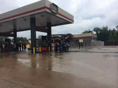
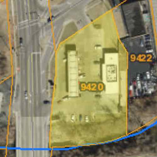
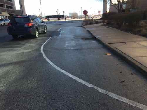
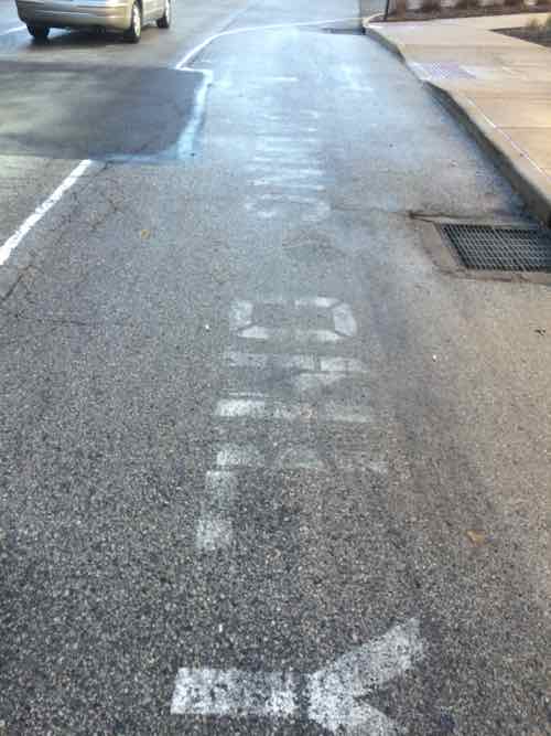
The boundaries of each plan, coincidentally, intersect at the burnt out QuikTrip (9420 W. Florissant Ave). The 1.14 acre site, on W. Florissant Ave, is bordered by Maline Creek on the South. Next week I’ll post about the Urban League’s intentions for this site and how they ignored two published plans with extensive community involvement. Today more detail on both plans.

West Florissant Avenue Great Streets Master Plan:

The Vision for West Florissant Avenue comes from community and stakeholder input received through multi-faceted outreach efforts. These have included public workshops and virtual walking tours, interviews with community leaders, input from the Community Committee and Technical Advisory Committee, an Agency workshop, and an online survey and mapping tool. The Vision Statement has distilled this community and stakeholder input, with the most significant community values expressed as how the corridor should look, feel, and contribute to the community’s future. 

Maline Greenway Concept Plan:

The Maline Greenway Concept plan presents the findings of a yearlong planning process that involved inventory, analysis and recommendations. Input from residents within communities along
the greenway helped shape the plan. The report includes background information on the District, summary of existing conditions, review of public input, description of the Maline Greenway concept, implementation overview and a summary of recommendations that include not only the trail alignment opportunities but also recommendations that address the social, economic and environmental quality of life for the communities. The Concept Plan helps to guide partnership opportunities, provides an analysis of the corridor, identifies community connections and alignment opportunities.

The West side of W. Florissant is very similar to the East. lots and lots of paving
The West side of W. Florissant is very similar to the East. lots and lots of paving. August 2014

From the Existing Conditions chapter of the West Florissant Ave plan, p20:

Ferguson’s zoning was updated as recently as 2011 and includes a downtown form-based code. Ferguson’s guiding comprehensive plan document is the Vision 2015 Plan Update that dates to 1998.

Page 24:

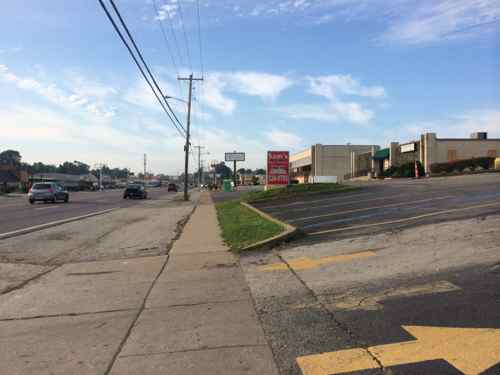
Although sidewalks are provided on both sides of West Florissant Avenue along most of the corridor, the pedestrian realm is generally uninviting and often unsafe. Buildings are spaced too far apart to walk, sidewalks are interrupted by frequent driveways and parking entries, and there are few pedestrian amenities or street trees.

Page 25 talks about transit and possible Bus Rapid Transit (BRT):

West Florissant also carries transit, specifically MetroBus Route 74 (Florissant line), and though the headways are long (30 minutes), Route 74 is one of Metro’s heaviest-used lines, with over 1.1 million boardings in 2013. West Florissant is crossed by MetroBus Route 61 (also in Metro’s top ten heaviest-used routes, with 800,000 boardings) at Chambers Road. The heavy transit use along the corridor results in a correspondingly heavy pedestrian demand. There is a clear opportunity to encourage transit- and pedestrian-oriented development at this intersection of West Florissant and Chambers Road.

While the current roadway configuration works relatively well for those traveling by automobile, and offers a transit option, other modes and users are largely shortchanged. West Florissant Avenue’s auto-dominated character and design, width, and traffic speeds, as well as the lack of any bicycle facilities, make it hostile to and unsafe for cyclists. Conditions for pedestrians are somewhat better, with the presence of sidewalks, but the pedestrian experience in many places along the corridor is unpleasant and unsafe.

With new high-quality transit service given priority along the corridor, and with rush-hour headways of 10 minutes, the opportunity exists to remake West Florissant Avenue into
a transit-first street, with transit-oriented, pedestrian-scale development clustered around some key stations along the corridor. The corridor has a relatively wide right-of-way, which will make allocating space efficiently to serve the multi-modal needs of all its users easier than if the street were narrower.

Chapter 5 Concept Plan, page 86:

New infill development should be guided by new zoning and guidelines that require buildings and entrances to be built up to the sidewalk, forming a consistent street wall. Until redevelopment occurs, individual property owners should be encouraged to beautify the edges of existing parking lots that front the avenue, so that the pedestrian experience is improved.

The study area of West Florissant Ave is long, but you have to start somewhere. From the Executive Summary:

Project construction should start at the south end, where there is high potential for redevelopment projects such as new housing, retail and mixed use projects. Thus investing public funds in this zone first follows a strategy that looks to catalyze private investment as soon as possible. Maline Creek is also planned to be reconstructed, so developers will be attracted to the critical mass of activity which will result in an appealing place for housing to be developed. Putting the South Gateway into construction in the first phase will also help create a rationale for the street design and use of medians and access management, simply because these street treatments are already in place immediately to the south, at Buzz-Westfall Plaza.

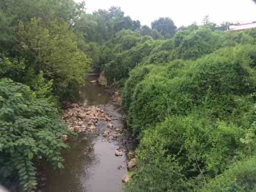
Maline Creek was identified as the point where the commercial development stops and residential begins, the former QuikTrip is on the residential side of Maline Creek.

Looking East at Maline Creek from West Florissant, the QT site on the left.
Looking East at Maline Creek from West Florissant, the QT site on the left. August 2014

From the Maline Creek Greenway Concept Plan Executive Summary:

Numerous park and open space areas exist along the proposed Maline Creek corridor which could potentially function as trailheads and Greenway amenities. Creating attractive linkages between parks and open spaces will promote public use and create the opportunity for the greenway to become a regional attraction. (p1.5)

After the trail leaves Ferguson’s Forestwood Park

Continuing east, the trail is planned to be located in open space at the north side of Maline Creek to West Florissant Avenue. From West Florissant Avenue the trail is planned to proceed south across the creek and then go east on the south side of the creek for approximately 2000 feet. A pedestrian bridge is planned in this area to cross the Maline Creek to reach the north side open space and continue east to Lucas and Hunt Road near Westview Middle School (p1.9)

The QuikTrip site could, perhaps, allow the trail to stay on the North side of Maline Creek.

In the interest of transparency and community involvement I think the community should share in setting the vision for the use of 9420 W. Florissant Ave. More next week.

— Steve Patterson


Sunday Poll: Should Ferguson Mayor James Knowles Resign?

Please vote in the poll, located in the right sidebar

Ferguson Mayor James Knowles, running unopposed, was reelected to a second 3-year term in April 2014.  Much has changed in the year since — following the recent Dept of Justice report we had the resignations of the city manager, municipal judge, police chief, and others.

Some feel Knowles should also resign, they’ve started a recall campaign:

Five residents notified city hall that they had formed a committee to gather signatures to force a recall election, the first step in a removal process outlined in the city’s charter. It appears the group would have 60 days to gather roughly 1,800 signatures, about 15 percent of the number of people who were eligible to vote in the last mayoral election. (Post-Dispatch)

So I ask the question: should he resign?  The Sunday Poll is at the top of the right sidebar and is open until 8pm tonight.

— Steve Patterson


Will the Urban League’s New Ferguson Center Be Urban or Suburban?

This afternoon the Urban League is going to give more details about something they released on Friday, a new center at the site of the burn-out QuikTrip on West Florissant in Ferguson:

On Friday, the Urban League said the center would be “an important extension of its services in North County to further the League’s mission of empowering communities and changing lives.”

The center will “expand the Urban League’s work to broaden access to education/job training, employment and economic self-reliance for residents of the St. Louis metro area,” the League said in a news release.

A news conference is set for Monday afternoon to announce details, which the Urban League would not provide Friday. (Post-Dispatch)

Job training is needed in Ferguson, a better-trained workforce will benefit the entire region.

nnn
The former QuikTrip at 9420 W. Florissant on  August 16, 2014, click image for map
St  Louis County records list the irregularly-shaped property as being 1.14 acres.
St Louis County records list the irregularly-shaped property as being 1.14 acres.

St  Louis County records list the property as being 1.14 acres with irregular borders. This afternoon we might see preliminary ideas for the planned building. Hopefully the Urban League is planning to build the structure out at the street corner, close to the public sidewalk. My fear is they’ll set a building at the back, behind parking. The latter would send the wrong message to a community with many who use sidewalks and public transit. Since they’ll be starting with a cleared site I’m hopeful, I applaud the effort but remain cautious until I see specifics.

The press conference will be held 3pm at the Urban League’s non-walkable St. Louis County Operations Center at 8960 Jennings Station Road. To be fair, it’s located in a rented former grocery store built in 1967.

— Steve Patterson.


Fifth Anniversary of River City Casino

A lot has happened in the five years since River City Casino opened just beyond the city limits in South St. Louis County. The President Casino on the Admiral closed four months later in June 2010. It seems like every remaining casino, at least on the Missouri side, changed ownership. August 2013:

The Federal Trade Commission required Pinnacle to sell one of its two St. Louis-area casinos as a condition of Pinnacle’s $2.8 billion purchase of rival Ameristar Casinos. Pinnacle completed the Ameristar purchase this week. (Lumiere casino sold to Tropicana for $260 million)

I’ve never been inside River City because 1) I don’t enter buildings where smoking is permitted and 2) I’m not a gambler. However, I did post on pedestrian access in March 2012 — see River City Casino Has Surprisingly Good Pedestrian Access Route.

River City Casino in south St. Louis County, 2011
Approaching the casino as a pedestrian
Approaching the casino as a pedestrian, 2012

I could be wrong, but I don’t think South Broadway in St. Louis saw the renaissance that was predicted. It seems we’ve just shifted gambling revenues to a new location.

— Steve Patterson


So Some ‘SCHMUK’ Parked In A Loading Only Zone

Since I started this blog more than a decade ago pedestrian access & walkability have been a regular theme — especially since I became disabled 7 years ago. Friday I encountered a car parked blocking a ramp. Being a car guy I tend to mention the make of car — it was a Pontiac that blocked a ramp on one of my first outings to the store in a wheelchair in 2008. The car on Friday happened to be a Mercedes.

"Mercedes owner blocked a crosswalk I needed at Richmond Hts MetroLink station"
I said “Mercedes owner blocked a crosswalk I needed at Richmond Hts MetroLink station” on Facebook & Twitter. Click to view on Facebook.
schmuk
I posted this picture of the rear vanity license plate “SCHMUK” on Twitter and in the comments on Facebook, click to view on Twitter.
schmuk
No license plate displayed on the front — as required by Missouri law. No snow or ice — just salt residue

I’m posting this to start a civil discussion about the physical design of the area and how pedestrian amenities are easily ignored.

These three images, above, were taken at 12:11-12:12pm on Friday afternoon, it was 43 °F just before noon.  Like everyone, I make mistakes.  When I do I admit as much.

Here’s what I got wrong:

  1. The ramp isn’t for a crosswalk, it’s for a passenger loading zone.
  2. It’s near the Brentwood MetroLink Station, not the Richmond Heights MetroLink Station — that’s located one station Eastbound on the Blue Line, which opened in 2006.

Very little discussion on Twitter, but Facebook erupted. Here’s some comments that remained as of yesterday (users deleted others):

Comments from a 23 year-old saying he’s the owner:

  • Thanks facebookers. This is actually my vehicle. I assure you that it was a clearly marked parking space and a car was actually parked behind me as you can see. The curbs are not marked yellow or anything. I apologize but it says nothing about not parking in that space. My plates are hilarious I know. Thanks dan for telling me about the post! Lets find something new to complain about now!
  • [After I said I contacted the police] “Omg. Like they don’t have more important stuff to worry about. Sorry you had an inconvenience. Again. The writing on the pavement was still covered in snow and ice.. Also why isn’t the other car being put on a blast? Because it was not a Mercedes!” 
  • Only tacky people use front license plates. Duh.
  • God my car is beautiful though isn’t it?!
  • I have apologized multiple times. No clear signs. No curb markers. No lines within the area. Also the other car hasn’t been called out. Just mine. I’m over the whole situation.

From his friends:

  • I find this city to be wasting more and more time on pointless endeavors that literally amount to nothing more than pessimistic chatter.
  • Go fight a war, go feed the homeless, save a child refugee…no chance of you becoming something of use to the world because you will all still be on facebook making a fool out of yourselves and the right of freedom of speech. No wonder this city is in turmoil… people being shot over petty crimes and people bitching about where cars are parked on a social media site during their off time. #sillyfirstworldproblems My finger tips were cut off a month ago. THAT is a problem. …get a life.
  • It’s the principle. I also am annoyed that my friend who is a very kind, successful individual who doesn’t deserve internet slander or harassment was being targeted as som e sort of criminal. It is as I said before petty, a waste of time, and pathetic.
  •  You guys are clearly uneducated morons! Had any of you spent as much time trying to be successful as you do running your mouths and posting stupid stuff on fb, you too could have nice things. Maybe then you wouldn’t have to run your mouth and judge ppl just to fill you free time it looks like a perfectly fine place to park to me!
  •  Wow! Pretty sure anyone who can afford a Mercedes can most definitely read! So you’re a wannabe photographer, I wouldn’t quit your day job just yet. Parking sucks all over stl & I’m sure that loading zone was so clear thru the ice that even you missed it! You even said so. I am truly nowhere near wealthy & even I have more to do in life than to be so dang petty over something so minimal! Josh is a wonderful person, I’ve known him his whole life! But you all see a Mercedes & automatically go to rich jerk….stereotype much! Sorry, I just think it’s ridiculous to waste this much time of your day venting about something when it would’ve taken 5 extra seconds to walk around the car a foot! They’re not going to give you a Jay walking ticket if there’s obviously a vehicle blocking what you THOUGHT was a crosswalk. Get a life…one where you have a legitimate reason to bash someone, for more than having money bcuz your attitude says that’s all your pissed about. Love ya Josh, glad you could handle this with the class you did, sorry, couldn’t shut my mouth when it’s about my adopted brother!
  • Wow. I know my friend would never intentionally try to hurt anyone or do wrong, as I’ve known him for eight years. Mistakes happen, and whether or not he parked incorrectly, I don’t think it warrants such persecution. He didn’t get a ticket, did he? Leave the law up to the police, not the Internet.
  • I love that the fact you’re driving a Mercedes is what is really pissing people off, [redacted]. If you were driving a POS (that’s Piece Of Shit, for you flipping idiots out there), no one would have even posted about this as that shit happens all the time! Find something else to be pissed about people. #youarethespoiledone.
  • How about using your anger to get the city to install signs on poles that would clearly state Loading zone. Not paint a street that would be covered with salt residue. do something useful instead of petty with your time.

His Dad removed his comments, but the one from his mom remains:

  • My son has apologized, he is a very caring and loving young man and has always obeyed the law, once again, we apologize for all the inconvenience.
    Loving Mother

One of his so-called apologies was this internet meme:

stopbeingpoor
Some may consider this an apology, I do not.

Another comment from the thread — from a personal friend:

I understand that it does not alway occur to people that parking in front of the sidewalk ramp prevents someone using a wheelchair from crossing the street– it is a concept that most folks have the luxury of not thinking about. The benefit of this thread is that it has had the potential to increase awareness (for those open to having their awareness increased). However, I don’t think “sorry you are poor” and related sorry-not-sorry apologies count as a sincere apology and referring to “inconvenience” is patronizing.

Friday I wanted to verify what another commenter had said — that it was clearly a loading zone on Google Maps. The aerial was too dark but the August 2012 Street View was clear, I shared the following screen shot in the thread.

In the comments I was accused of photoshopping the words LOADING ONLY even though I included a link to see it on Google -- click to view.
In the comments I was accused of photoshopping the words LOADING ONLY even though I included a link to see it on Google — click to view. I couldn’t photoshop the above, much less hack Google.

We were out that way Sunday afternoon so I drove through to check it out from a motorists prospective.

Right off Hanley you see a loading only zone with a solid white line and a sign. He was parked further West, let's see how it looks.
Right off Hanley you see a loading only zone with a solid white line and a sign. He was parked further West, let’s see how it looks.
Again, a solid white line that curves back to the curb is a good clue this isn't for driving or parking.  The text is faded and no sign is posted like the previous spot. The ramp is very visible,
Again, a solid white line that curves back to the curb is a good clue this isn’t for driving or parking. The text is faded and no sign is posted like the previous spot. The ramp is very visible,
A close up of the fading text, but the solid white line and ramp are pretty clear.

This entire development is poorly designed  — it doesn’t work well for both motorists and pedestrians. After the I-64 rebuild Musick Memorial Dr became a public street, it’s how you get to Westbound Eager Rd from Hanley. From the various comments I got the view that everything East of I-270 is “the city”, with what the rest of us know as the city being downtown.   St. Louis has no responsibility for Musick Memorial Dr — that falls to either the developer or City of Brentwood.

If only there was  a massive parking garage where he could’ve parked.

— Steve Patterson


Advertisement


[custom-facebook-feed]

Archives

Categories

Advertisement


Subscribe