Most older streets in St. Louis were paved in cobblestones or paver bricks, few exist anymore. Asphalt paving is significantly smoother, just far less attractive. In 1953 the Cochran Gardens high rise public housing complex opened, but construction closed off 8th Street between O’Fallon Street and the alley south of Cass Avenue. Eighth Street was reopened when the high rise towers were replaced with the mixed-income Cambridge Heights townhouses & apartments, except 8th wasn’t connected through to the little stub of a street to Cass.
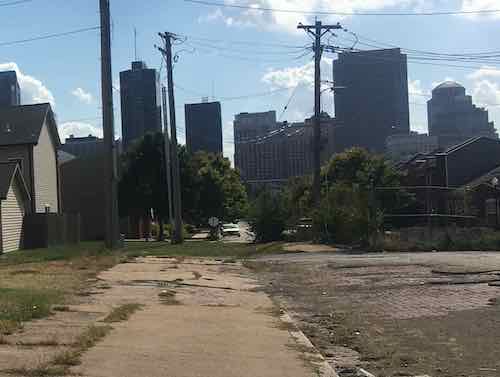
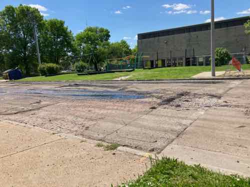
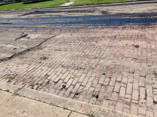
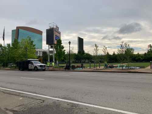
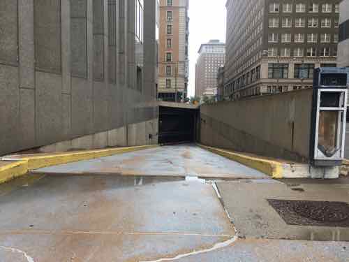
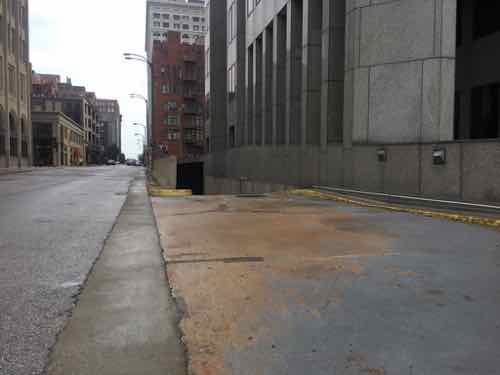
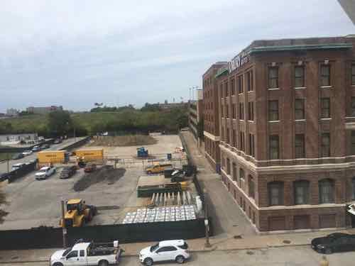
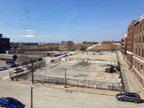
This October 2, 2019 view is looking south on 8th from Cass. You can see the land just after the alley, Cambridge Heights, and the downtown skyline on the horizon. In the foreground you can see brick pavers. It looked like it had been paved over decades ago, but most was long gone so the old bricks were exposed.On May 5th I returned home tfrom a press conference at the Chain of Rocks water treatment plant to see city crews paving over the small amount of bricks.Closer viewA couple of days later I went back to see the finished results.The concrete in the foreground was part of the new river bridge project, when Cass was raised in height over the interstate.
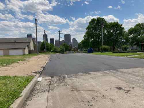
This half block of 8th Street gets very little traffic, the uniformity of the asphalt paving does look better than it did with patches of old asphalt and broken bricks. This is better, but I still miss seeing the bricks.
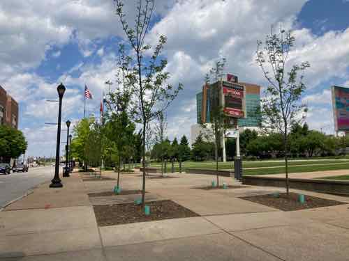
Early last month I saw landscapers planting new trees along Broadway next to Baer Plaza, across from the dome.
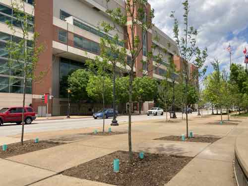
On May 3. 2021 I saw workers busy planting new trees on the east side of Broadway.
I frequently take Broadway to/from the central business district. Living north of the convention center & dome, Broadway (5th)& 9th are the only options to get around the massive facility that closed 8th, 7th, and 6th streets. Sometimes to make things interesting I roll on the east side of Broadway, so I knew exactly where they were planting.
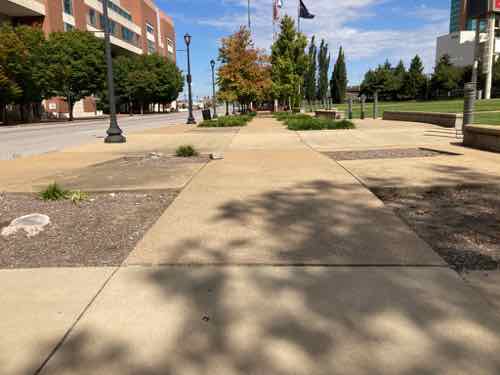
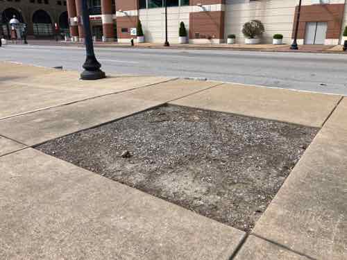
On October 1, 2020 I snapped a few pics of the empty spots where trees had once been:
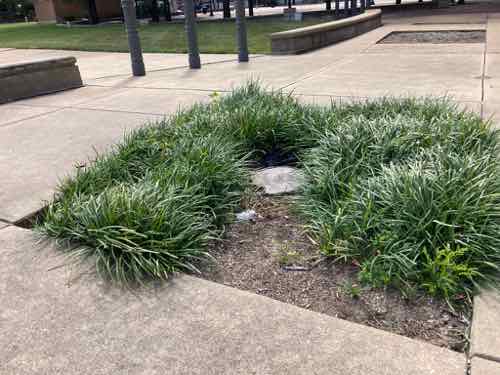
Looking north you could see the numerous empty squares where the allee vanished.Some were just bare dirt.Others still had some liriope (aka monkey grass)
There were 11 trees missing, very obvious sign of neglect. Not sure why, but I didn’t post the pictures to social media. So last month I was very happy to see workers busy planting eleven new trees. I retuned on May 7th to get these pics.
The new trees are small compared to the more mature trees further north, but they’re quite big for new trees.Another view.
I don’t know trees to tell you the variety or how fast they’ll grow. Hopefully within a few years they’ll fill out nicely. I’m going to take the east side of Broadway more often, especially when going to Laclede’s Landing, Eads Bridge, Arch grounds, etc.
More than six decades ago 9th & 10th streets were changed from two-way to one-way in the opposite directions — a one-way couplet. This still exists from Clark Ave on the south to Cass Ave on the north — a distance of 1.2 miles. The north end used to continue past Cass to connect to I-70, but it was shortened when construction on the newest bridge over the Mississippi River began approximately 15 years ago. The south end still connects to I-64 ramps.
The purpose of one-way streets decades ago was to quickly get cars into downtown in the morning, then back out after work. They did their job…a little too well. Downtown was so quick to empty out nobody stuck around for shopping, dinner, or a show. There many reasons why downtowns emptied out, but one-way streets were a major contributor. To make downtown St. Louis enjoyable as a place to live, work, and visit all the one-way streets need to return to two-way traffic eventually. When Locust Street west of 14th switched back to two-way a dozen years ago it made a huge difference.
For nearly 50 years 9th & 10th extended north of Cass Ave to connect to I-70, but that ended with the 2010 start of a new bridge over the Mississippi River, later named the Stan Musial Veterans Memorial Bridge. But downtown 9th & 10th weren’t the original couplet of paired opposite direction one-way streets.
Let’s look at the original one-way couplets in the downtown central business district (Arch to 12th/Tucker):
Northbound 4th & southbound Broadway (aka 5th)
Southbound 6th & northbound 7th
Southbound 8th & northbound 9th
Southbound 10th & northbound 11th
The first still exists today, the rest have all been changed to the point they no longer function as original intended. Three streets lots blocks to the convention center & dome: 6th, 7th, 8th. Ninth will soon be added to that list. Sixth street lost blocks to Kiener Plaza & the hotel south of Market. Both sixth & seventh streets lost blocks to the original downtown Busch Stadium (now Ballpark Village), and the current Busch Stadium. And finally northbound 9th Street is closed for one block between Market & Chestnut because the designers of Citygarden didn’t think about a pedestrian signal at 9th & Market. D’oh!
I’ve posted about changing these opposite one-way streets back to two-way traffic numerous times, but now it’s urgent. When the convention center expansion begins a couple of blocks of 9th will be closed, but that’s not the urgent reason for restoring two-way traffic. The vacant AT&T Tower downtown at 909 Chestnut (bordered by 9th, Chestnut, 10th, and Pine) is why these streets need to revert to two-way traffic. Why?
909 Chestnut was built at the headquarters for Southwestern Bell Telephone, later purchased by AT&T
The entrance and exit to the small underground garage was designed with the one-way streets in mind, the entrance was off northbound 9th and the exit was onto southbound 10th. The 44-story building has been vacant since 2017, but eventually someone will renovate it. When they do it would be easy to switch the entrance and exit. If the building is renovated while 9th & 10th are still one-way it’ll be impossible to make them two-way in the future.
The original entrance off nb 9th could be an exit after future renovations.The original basement entrance could just as easily be the exit.On the opposite side of the building we have the original exit onto sb 10th. Again, this could easily be the entrance if 10th was two-way.
Since built, exiting traffic has come out southbound just before Chestnut. Switching the exit from 10th to 9th wouldn’t change this potential conflict point.
The building has lost value and changed hands numerous times, eventually someone is going to renovate it.
The 1.4 million-square-foot, 44-story office building on Chestnut Street is the largest office building by square-footage in the region, and the 1986 structure built for a single tenant has posed a vexing challenge amid a downtown market already struggling with the highest office vacancy rate in the metro area.
AT&T vacated its lease in September 2017 and about 2,000 of the company’s employees relocated nearby in buildings at 801 Chestnut and 1010 Pine streets. (Post-Dispatch, May 2019)
For comparison here are some other large vacant buildings downtown
Since 909 Chestnut was built as a headquarters it was connected to buildings to the east & west. Another block west was a large company parking garage. The garage under 909 Chestnut is small, was built for service vehicles and company executives. A MetroLink light rail station is only a block away, but parking obsessed assumes everyone has a car.
The building footprint is too small to ramp up to use some upper floors for parking. A car elevator or automated system are the only options to get cars up higher, but they’re very costly.
Eventually someone will figure it out. When they do 9th & 10th should be two-way traffic.
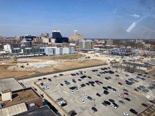
In February 2016 the St. Louis region was still accepting the fact the Rams were returning to California, our proposal to clear the north riverfront for a new National Football League (NFL) stadium had been rejected — by Kroenke or voters…can’t remember.
Also in February 2016 Major League Soccer (MLS) expressed interest in St. Louis as an expansion city. I didn’t want the historic north riverfront to continued being targeted, so I proposed a different site. A site I’d wanted to see redeveloped for years. The short remnants of the never-built 22nd Street Parkway.
This image is from that February 2016 post, taken from the adjacent hotel.
I haven’t been back to that hotel yet, but I have ridden the St. Louis Wheel at Union Station. Twice, in September 2019 and earlier this month.
Today’s post is a look at similar views from those two visits, nearly 18 months apart.
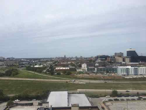
Before: looking northwest on September 24, 2019During: a similar view as above on March 7, 2021. In time the Union Station surface parking lot in the foreground will get developed.
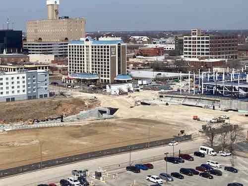
Now for a cropped view focusing on Market over the 22nd Parkway.
Before: the Market St bridge and the ramp up to it had been there for decades. I saw the big hole on the other side of Market as an architectural advantage.During: the decaying Market Street bridge is gone! The new MLS stadium is set into the hole. A tunnel will provide service access to the stadium.
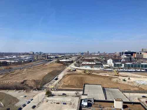
Now looking west:
Before: The 22nd Parkway cut a slice between 21st & 22nd streets. Prior NFL & MLS stadium proposals were here, wedged up against I-64.During: for the first time in 6+ decades Clark Ave will be uninterrupted between 20th & Jefferson.
It’s even more exciting closer to street level.
Before: pretty much a dead zone in 2019.During: you can see Clark Ave taking shape. Eventually the long vacant land in the foreground will be developed.
It is very exciting to see this area beginning to recover from the damaging 22nd Street Parkway project. It’ll take years to fill in, but it’s better to naturally fill in over time than to be an all at once infill project.
In 1990, at just 23, I fell in love with St. Louis and its quirky street grid. I hadn’t yet been to New York or Chicago but I knew many big cities had rigid orthogonal grids — nothing but right angles.
St.Louis’ grid, on the other hand, had right, obtuse, and acute angles. This meant interesting views from various directions, buildings designed to fit into the odd-shaped parcels. Some streets follow old trails, the neighborhoods built up around the meandering paths.
I simply adore this about St. Louis.
In my first 6-9 months here I made my way along North & West Florissant Avenue as it makes it way up through North St. Louis. My destination was O’Fallon Park — the neighborhood and city park.
Right before the park was the remnants of once-thriving commercial district. I’ve been back there many times over the years in a car, bike, bus, and motor scooter.
From the bus on August 5, 2017, looking at West Florissant Ave & Harne Ave. Click image to view in Google Streetview
This old commercial area is the center of a new revitalization project called “The City District.”
Phase One During the $34 million Phase One, 66 parcels will be demolished and the land will be reallocated for new construction of retail, homes and community greenspaces. More than 50 percent of these properties are currently vacant. The construction team is working on master plan and design development and bidding. Demolition will begin in March. Kwame Building Group is serving as the construction manager and program manager. The architect is Jackson Design Group.
In Phase One, the construction team also will build City Plaza, which will create vibrant shopping and recreational opportunities and a thriving local labor force. The commercial center will feature extensive retail and office space, including a grocery store and bowling alley.
Phase Two The O’ Fallon Neighborhood is home to some of St. Louis’ largest and most historical homes rivaling the size and stylings found in the Central West End and surrounding Tower Grove Park and Forest Park. In Phase Two, $1 million will be invested in rehabilitating 26 existing homes. Large single-family homes will be converted into multi-use rental properties while retaining their architectural history. A $24 million project will construct new single and multi-family homes.
Culturally competent and equitable redevelopment practices will be central throughout the five-year project. The KWAME team is committed to maximizing MBE/WBE and local firm participation. The project team has established a partnership with the City of St. Louis to increase community safety and security focused on community competent policing. Existing infrastructure will be reimagined to improve and promote public transit and pedestrian accessibility. (Kwame Building Group)
My initial thoughts are generally positive, the area desperately needs investment after decades of disinvestment by whites and then blacks. I’m very glad this effort is coming from the black community, not an old white suburban developer. It’s a very good thing they’ve given this commercial district a name — that’s important for creating a positive identity.
However, I’m very concerned about demolition of currently occupied structures. Reallocating land sounds like making wide suburban lots rather than the existing narrow lots with garages and services off the alley. How the large triangle created as West Florissant splits is treated will be very important. It’s all asphalt now. Lots of unanswered questions.
Wisely they’ve said it will take multiple phases and five years, though I expect it’ll take even longer. And that’s ok, it didn’t decline overnight so we can’t expect an immediate reversal. I’m looking forward to seeing more details.
AARP Livibility Index
The Livability Index scores neighborhoods and communities across the U.S. for the services and amenities that impact your life the most
Built St. Louis
historic architecture of St. Louis, Missouri – mourning the losses, celebrating the survivors.
Geo St. Louis
a guide to geospatial data about the City of St. Louis