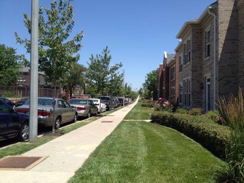
Escalators are great, very helpful to those who find stairs difficult. However, like elevators, they’re expensive to install and maintain. Escalators exposed to the elements are even more challenging to keep in operation.
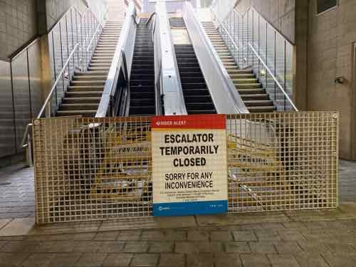
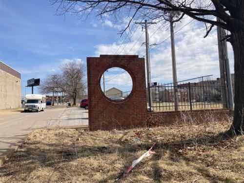
When our original light rail line opened in 1993 two stations were located within an old freight tunnel under the central business district (CBD). The Convention Center and 8th & Pine stations were designed with stairs, elevators, and escalators. Because the tunnel is narrow the tracks are in the center, the passenger platforms are on both sides — one per direction of travel, east or west. This meant a total of four elevators and four pairs of escalators — all exposed to elements to a degree.
When the Shrewsbury (Blue) expansion line opened in 2006 its three underground stations had stairs, elevators/ramps — no escalators.
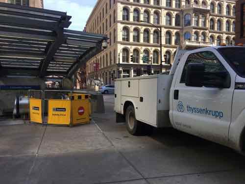
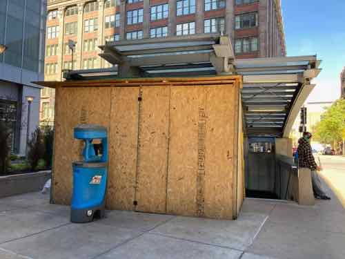
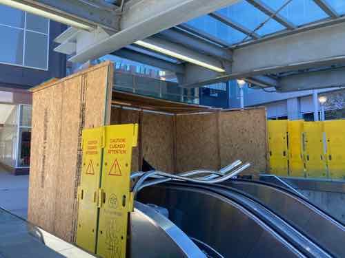
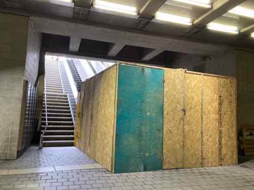
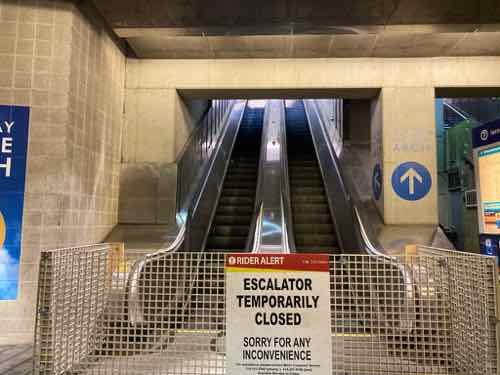
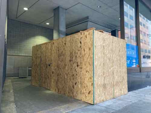
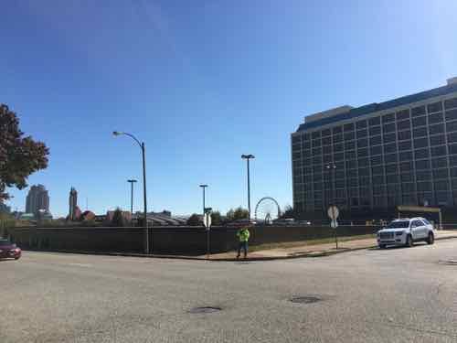
In 2018 & 2019 I’d frequently see ThyssenKrupp maintenance people working on the Convention Center escalators, or at least their service truck on the public sidewalk near the westbound entrance/exit. April 1, 2019Here’s the same location on November 2, 2020Another view, with parts visible. November 2, 2020View from the platform level. November 2, 2020The big plywood barricade has been gone for quite a while, but the escalators remain out of service. March 7, 2022The eastbound escalators at 8th & Pine have been a similar story. Note access to the elevator is on the right, back — between the escalators and stair. April 21, 2021.The street entrance of the eastbound 8th & Pine station after the plywood construction barricade was constructed, steps & elevator are accessible. March 1, 2022
I search all Metro press releases from 2019 through the present, only one mentioned escalators in the subject/summary.
From May 3, 2021:
Rehabilitation work on the westbound escalator at the 8th & Pine MetroLink Station in downtown St. Louis begins on Tuesday, May 4. During this project, the station’s westbound elevator will remain in service, however, the accessible pathway to the westbound side of the 8th & Pine Station (near Pine Street) will have to be closed temporarily.
MetroLink riders who are traveling to or from the 8th & Pine Station and use a wheelchair or mobility device may need to make adjustments to their commute, as it will be necessary for riders to use stairs (located near Chestnut Street) when entering or departing the westbound side of the 8th & Pine Station.
The escalator rehabilitation work is expected to take approximately three months to complete. (Source: Metro)
The above press release was issued a week after I followed up with Metro again since I hadn’t received any specifics from my inquiry on December 28, 2020. Receipt of my original inquiry was acknowledged but I never received anything. Just the one press release, above.
Since I use my power wheelchair when using transit why do I care if the escalators aren’t working?
Well, it looks bad to have something temporarily non-functional for days, weeks, months..years.
What do I hope to accomplish with this post? I want all the escalators either in good working condition — or I want them removed and replaced with fixed stairs (I can’t speak to concerns of those who have a hard time with stairs). It obviously won’t happen quickly, but steady progress needs to be demonstrated.
It looks very bad for visitors to see out of service signs, but it’s even worse when returning visitors say “oh yeah they were out the last two years I’ve visited.”
As I outlined two years ago, the blocks around new Centene Stadium will most certainly change in the coming years, decades. We’ve already seen some buildings on Olive be razed for the stadium, and more for a new garage. These weren’t architectural masterpieces, but they were urban. Hopefully it’ll be a good trade off.
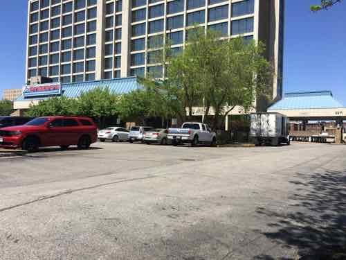
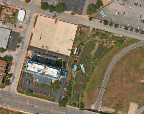
One building I want to see razed, or significantly altered, is the hotel at 2211 Market Street (2.78 acres). Currently it’s officially known as the “Pear Tree Inn Near Union Station.” With the new major league soccer stadium nearing completion next door I think they’ll rename the hotel to reflect the ideal proximity. I’d like to bigger change — a complete rethink.
The 11-story hotel was built in 1965. It is set back from Market Street behind parking. It doesn’t orient to any of the three streets (Market, 23rd, Pine) that has bordered it since new.The 2-level parking garage to the north of the tower was built at the same time.
One of the first things I like to do is look back at what existed before — especially streets & alleys. Not that I’d necessarily want to recreate what existed over a hundred years ago, I just find it helpful.
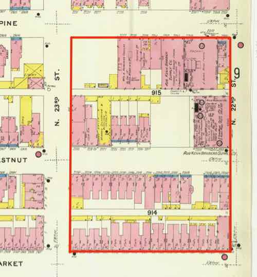
In February 1909 we can see Chestnut between Market and Pine, 22nd on the east, 23rd on the west. City blocks 914 & 915.For decades is was next to what was planned to be the 22nd St Parkway. This interchange was all that ever got built.Now the new MLS stadium is going up, and 22nd Street will once again exist!
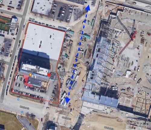
Interestingly, the little bit of land between the east side of the hotel and the new 22nd Street is deeded in several small parcels, at least one to TKFC Properties, LLC in Moscow Mills, MO. The accessor classifies it as “9900 (OTHER UNDEVELOPED LAND AND WATER AREAS, NEC)”, so perhaps it’ll collect runoff water. Seems too valuable for water retention.
I strongly dislike this hotel and parking garage. I suspect the owner, Drury Hotels, is contemplating their options now that their real estate has a prime spot near the MLS stadium, and a higher valuation. The big question is what are the various ways to rebuild or start over?
I believe in reusing existing structures, so the first option would be to look at adding a new tower perpendicular to the existing one so hotel rooms on the east side could look toward the stadium and downtown. The roof of a new tower could contain a rooftop restaurant/bar with outstanding views. A new urban entrance facing Market, 22nd, or Pine. Some sort of drive though for check in that doesn’t block the many pedestrians that will soon be in this area. Parking will need to go somewhere, preferably underground.
Other options involve razing the tower and garage, completely starting over from scratch. If they get the little bit of land between the existing lot and 22nd Street the site will be bordered by four streets — it needs to acknowledge all of them.
Reconstructing Chestnut Street needs to be considered. Chestnut still exists between 23rd and Jefferson Ave. so this would help reconnect the original street grid. We would then have two parcels, with the north larger than the south. Perhaps a parking garage in the center of the larger parcel, wrapped in hotel rooms, apartments, and/or offices? The new block of Chestnut might be a full public street, a public walkway, or a private walkway that’s generally open to the public. I can see a Chestnut walkway being filled with outdoor dining, a new building(s) on the south side blocking the hot sun.
My one time in the hotel was to get this photo from the hallway of an upper floor. This was the view I used in my February 2016 post when I called for this to be the site of a new stadium — over six years ago! Click image to view post.
I’m confident this site will look dramatically different within a decade, just not sure how it’ll look. If I’m still around when something happens I’ll be sure to post about it.
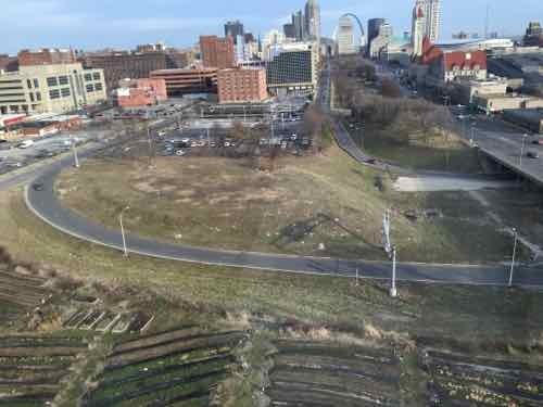
Monday’s post was about reconnecting the pedestrian grid at 8th Street, just south of Cass Ave — see 8th Street Walkway Needed To Fill Missing 110’ Connectivity Gap. Today’s post is about exploring options for new housing on the large lot known as 801 Dickson Street — it stretches a full block along the north side of Dickson, between 8th & 9th streets. This vacant land is owned by the St. Louis Housing Authority.
First we’ll look at the site, conditions, etc. and then some of the various configurations I’ve considered. You may have others.
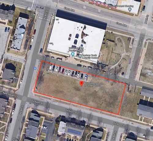
801 Dickson is owned by the St. Louis Housing Authority, zoned D Multi-Family Housing. The strategic land use is NPA — neighborhood preservation area. The long sides are 292.52 feet, the east/right short side is 110 feet, and the left/west short side is 120 feet. Click to view in Google Maps — sans boundary lines.
Site characteristics:
Faces south-southwest.
Gentle slope south from alley.
The parking for 12 cars at the alley has been in place for 70 years, it lacks an accessible space and adjacent loading zone.
The Youth & Family Center on the north side of the alley was built in 1982. It was previously called Cochran Youth & Family Center. It has entrances onto Cass and the back alley. It has no parking on its site at 818 Cass Ave. Nobody ever parks on Cass Ave, even though it isn’t marked as no parking.
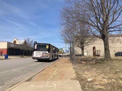
A northbound bus stop (#32) is on the short side, on 9th Street.
Overhead electric enters the site on the east side, about 20 feet south of the alley. The poles and overhead wires stop just before 9th Street (left side).
Some mature trees exist along the alley, 9th. Smaller street trees exist along Dickson Street. The trees next to the alley have been trimmed so as to not interfere with the overhead power lines.
The west end had part of Cochran Gardens tower C-9 from 1951 until about 2005, the west end was part of a Cochran Gardens playground. Presumably the building foundations were fully removed. Potentially 19th century remnants remain buried.
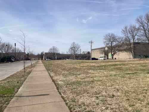
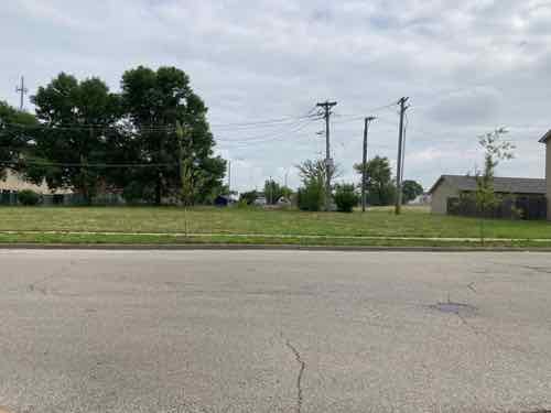
Looking west at 801 DicksonLooking north on 9th, at Dickson. The #32 bus frequently stops here to drop off a rider, or let one board.Looking back east from 9th, the brick circle is all that remains from Cochran Gardens. Parking & electrical poles are visible.A direct view of the parking from the alley. Again, the overhead electric is visible.
Before getting into the various options for new construction please understand this post isn’t concerned with who would build any housing, or how it would be paid for, demand, market economics, etc. The purpose here is to see the various options for constructing additional housing on the site — what does & doesn’t physically fit on the site. Ideally I’d like to avoid a curb cut/driveway off both Dickson & 9th streets.
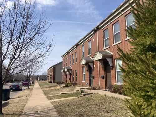
A good plan to start with ideas is to look at the context, the housing around the site. To the east of where I want a new 8th Street pedestrian walkway the dimension between 8th and 7th is just a few feet wider. It has two buildings, each with four townhouses. Along the alley are two garage buildings, each with a 2-car garage — one for each of the 8 total townhouses. When Cochran Gardens was replaced all the new construction, like my apartment, is rental — but each of the 8 townhouses are privately-owned, owner-occupied.
Row houses 7xx DicksonGarages behind 7xx Dickson
The problem is the aforementioned parking spaces off the alley, on the west end of the site. If the trees along the alley were removed you could building one group of four townhouses, with garage. You could do a second if the parking were removed, but that’s not ideal.
Directly across Dickson Street are more townhouses, these are mixed-income rentals with a common shared parking lot behind. Theoretically it may be possible to put a shallow parking lot behind townhouses.
This is a 2012 view of townhouses on 9th Street, the ones facing Dickson are similar.
The other contextual option is a building with garden apartments. The Cambridge Heights garden apartment buildings each contain 12 apartments — 3 floors, six units per two entrances/breezeways. Like townhouses, parking might be possible behind. One such building could fit. A variation with 18 units with three entrances/breezeways could potentially fit.
What about going higher than 3 floors? While elevators are expensive, and costly to maintain, a 4-5 story building could work as you get more units in the same space. The scale of an old 5-story building on 7th seems fine in the neighborhood. I’d love to see a lot of accessible units as the need for low-income housing for the disabled is needed — especially near downtown. With an existing bus stop adjacent it would be great for many people who don’t drive or own a car, this would make it easier to not have any off-street parking. Perhaps the site is arranged so a small parking lot is located off the alley, on the east end of the site.
It would be nice if an elevator building had a retail space at the corner, perhaps part of a live/work unit.
Another option would be groupings of tiny homes (300sf) or small homes (800sf). Some could front onto the 8th Street walkway I’d like to see get built. Since the site is a block long there’s nothing to say it all has to be the same, some combination of ideas can be used.
The parking at the alley for the Youth & Family Center should probably be separated from the main lot, or a formalized easement. It would also be nice if the overhead electric was buried. The St. Louis Housing Authority also owns a larger lot between 8th & 9th, on O’Fallon Street (map), but kids often use this for ball, frisbee, etc.
The vacant land in my neighborhood, owned by the housing authority, is ideal for affordable/low-income new housing — perhaps by a developer seeking a tax break on a big project in the central corridor.
When cold water flats and tenements were cleared just north of downtown for St. Louis’ first high-rise public housing project, Cochran Gardens, several blocks of 8th Street were erased from the grid. Six decades later 8th Street was rebuilt* when the mixed-income Cambridge Heights apartments & townhouses replaced Cochran Gardens’ towers.
* 110 feet of 8th Street wasn’t replaced!
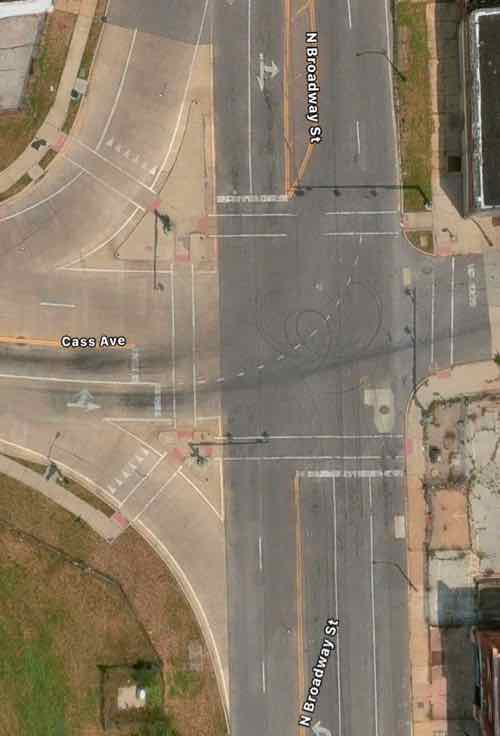
This short missing piece is a connectivity problem for those of us who live here. Later, when Cass Ave over I-44 (aka I-70) was raised as part of the Stan Musial Veterans Memorial Bridge project 7th Street got disconnected from Cass Ave. So now neither 7th or 8th connect to Cass. Getting to/from the bus at Cass Ave & Broadway is likely the primary reason for needing access here, it would also be nice when we go to Shady Jack’s or walk/roll up Broadway.
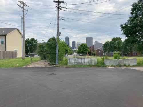
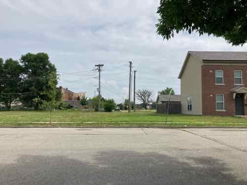
A little bit of the original 8th Street exists south of Cass Ave, but it quickly ends at an alley. Jersey barriers exist to keep drivers from going straight ahead.From the broken sidewalk on the east side of 8th you can see a clear route to 8th Street 100 feet further south. The west side of 8th, unfortunately, has no sidewalk.In the field you can see beyond Dickson Street to 8th StreetAt the public sidewalk you can look south along 8th Street to downtown. 8th Street is the center of Cambridge Heights.
Motorists use the alley south of Cass to get to/from Cass Ave, but pedestrians often walk though vacant land where 110 feet of 8th street should be. As you’ll see, putting in street, curbs, drainage, etc would be challenging & costly — all that’s needed is a 110 foot long sidewalk and a couple of curb ramps.
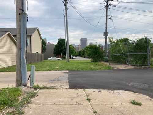
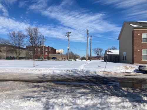
Looking toward Cass Ave from the SW corner of 8th & Dickson streets.Looking toward Cass Ave from the SW corner of 8th & Dickson streets.The same view after a recent snowfall. Two desire lines where people walked are clear. A community center is visible on the left, but no good way to get there directly.
This is needed because going between the neighborhood and Cass Ave is challenging as a pedestrian. I’ve thought so for the 3+ years I’ve lived here. I’ve also seen a woman at least 15 years my senior (so 70+) walking though the grass with a cane. The trail through the snow earlier this year was also a clue.
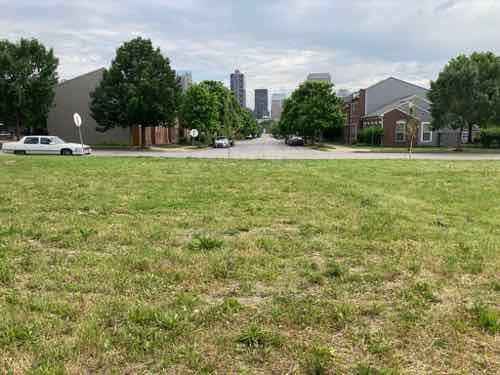
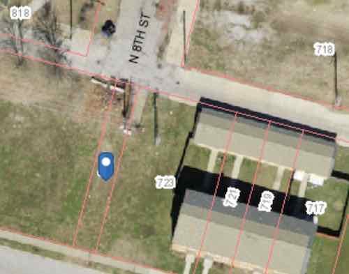
You might be thinking this land is vacant do it can be developed for more housing. Let’s take a look at the property lines.
The blue dot marks a 15 foot wide parcel owned by the St. Louis Housing Authority (725 Dickson Street). They also own the land from here to 9th Street. 723 Dickson Street is 64.26 feet wide, includes the 22 foot wide end of 3 townhouses.
My assumption is the 15 foot wide parcel known as 725 Dickson (map) is there to prevent anyone building over utilities, like sewer, under the old 8th Street. The end row house has a lot of extra land beyond their fence. Basically there’s more than enough width to create a generous pedestrian path. There are some obstacles near the alley.
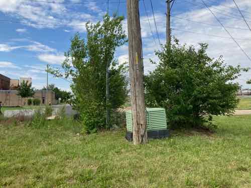
From the alley you can see a little bit of concrete and some useless chain link. And an electric utility pole.From the lot you can see the pole and an electrical box (transformer?). There are also wires to help keep the pole upright on the private land side.
There’s room to fit a 5′ wide walkway at the alley to then toward 8th & Dickson streets, we just need to figure out property lines, utilities, easements, etc. City mowers have a hard time during the summer keeping the back area cut — a private home owner would get a violation letter from the city for such conditions. The elevation is slightly higher at the alley than south at Dickson Street.
The need exists, much of the land is owned by the housing authority. Cost wouldn’t be that substantial. I’d love to see fruit trees planed on both sides of a walkway so the public can access free fruit.
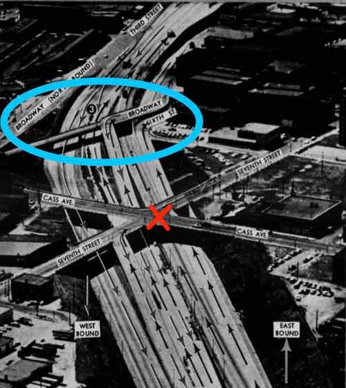
Urban highways & interstates allow drivers to get from point A to point B quicker than had they taken surface streets, but they’re also a major divider between the existing neighborhoods they cut through. In the late 1950s the downtown’s 3rd Street Parkway was being extended north, eventually connecting with the new Mark Twain Expressway (aka I-70/I-44) in July 1961.
I live on the west side of the highway, but I can stand in my kitchen and see Broadway & Cass, on the east side of the highway. I know first hand how the highway divides the historic north riverfront from my neighborhood, Columbus Square.
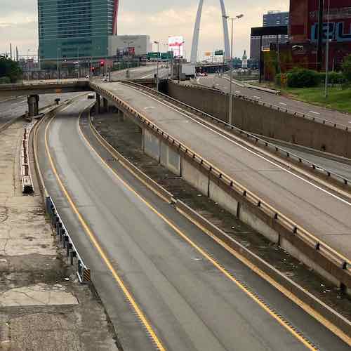
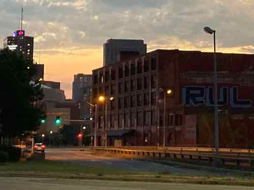
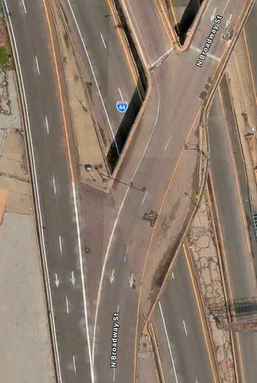
Looking south from the Cass Ave bridge over I-44, June 2020. The lane center is a southbound express lane, to the right is the express lane exit ramp to southbound Broadway.
Ideally we’d remove urban interstates and weave our neighborhoods back together, but that’s never going to happen. What should happen is when we rebuild crumbling infrastructure we add connections civil engineers in the 1950s never considered at the time the highways were planned.
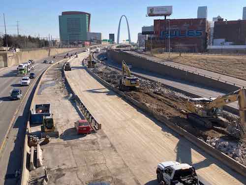
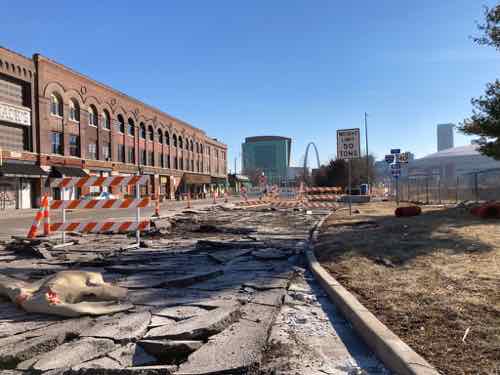
The same view Monday with southbound Broadway bridge and the exit ramp gone.The blue oval is the southbound Broadway bridge, the red X is where Csss & 7th were connected until construction began for the Stan Musial Veterans Memorial Bridge. Post-Dispatch July 9, 1961, p161.
The distance from Broadway & Cass to Broadway & O’Fallon is only 2/10 of a mile, but the distance required for the last 60 years has been double that — 4/10 of a mile.
The Missouri Department of Transportation supports pedestrian facilities:
MoDOT works with planning partners to create transportation facilities that work for all users because we value bicycle and pedestrian travel. Accommodating for bicyclists or pedestrians may be as simple as providing a well-designed road that all road users share or as complex as a separate-grade structure, such as a bridge. Developing appropriate facility design for nonmotorists depends on a variety of geometric and operational factors that are inter-related, such as available right-of-way, projected traffic counts and adjacent roadway design speeds.
We strive to integrate nonmotorized travel into the existing system to provide connections where none exist to promote efficiency and to focus on a primary concern—the safety of those who depend on walking or bicycling to reach their destinations. (MoDOT)
Unfortunately MoDOT failed to accommodate the needs of cyclists and pedestrians in the replacement. This is a huge mistake — it’ll be another 60+ years before we get another chance to reconnect these areas.
View from Broadway near Cass looking SW toward Broadway @ O’Fallon (just beyond building), June 2021The buildings on the right are part of a National Register Historic District.
You might be thinking it would be too difficult to include a pedestrian sidewalk. The old bridge, removed over the weekend, couldn’t have easily been retrofitted. But when building the new bridge entirely from the ground up it is actually pretty easy.
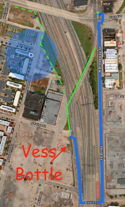
Here’s the overview:
The blue circle is my location. The blue line represents the route required to walk from Broadway @ Cass to Broadway @ O’Fallon — twice as far as the direct route shown in solid green. The dashed green line is how to connect Cass to 7th & 6th streets. Apple Maps
Now let’s take a look at the old bridge and highway exit ramps.
Broadway is only one lane per direction north of Cass, but it widens to 2 right turn lanes onto westbound Cass and 2 southbound lane to continue across the highway. One lane expands to four! Apple MapsSo 2 lanes of Broadway continued over the highway. The express lane exit is one lane but the Broadway exit is 2 lanes. Four lanes continue toward Cole before getting reduced to 2 further south.
The solution is the one southbound lane of Broadway splits into 3 before Cass — one left, one right, one straight ahead. This means the same width bridge can also accommodate bikes & pedestrians. The traffic exiting the southbound express lane and the highway have plenty of length for drivers to decelerate. Rumble strips (or similar) can be used to communicate to the driver to slow down as they approach Broadway. The 2 highway exit lanes can narrow to one before Broadway. Not sure if signals are necessary or just a flashing red light and notices to yield to pedestrians.
I would like to see Broadway south of Cole to return to two-way traffic in the future, so I’d like the new bridge to accommodate 2-way traffic and pedestrians on one side.
Again, I’m trying to connect two areas that have been separated for over 60 years. Both have enormous potential for redevelopment — new construction & adaptive reuse to the south and mostly captive reuse to the north. I’d love to see football fans have pre-game drinks at Shady Jack’s Saloon and then walk down to the Dome to see the St. Louis Battlehawks when the XFL returns under new ownership.
AARP Livibility Index
The Livability Index scores neighborhoods and communities across the U.S. for the services and amenities that impact your life the most
Built St. Louis
historic architecture of St. Louis, Missouri – mourning the losses, celebrating the survivors.
Geo St. Louis
a guide to geospatial data about the City of St. Louis