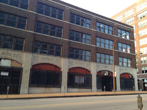
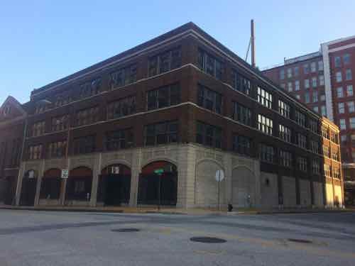
1701 Locust is a handsome 4-story building built in 1926. It has had several owners in the last decade.The facades facing Locust & 17th have double-hung windows on the upper floors, the North facade has steel factory/warehouse windows.
The building, in the block West of my loft, will be divided into apartments. Looking forward to seeing this long-vacant building come back to life!
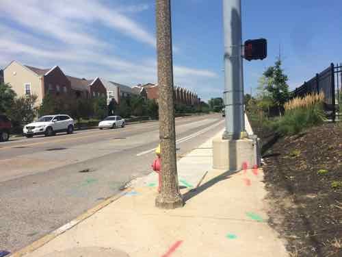
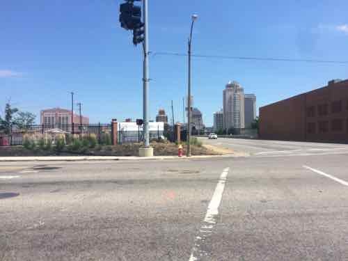
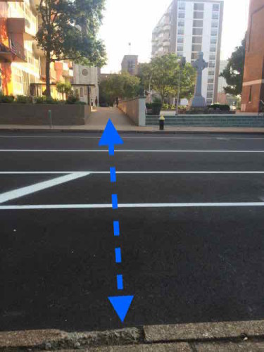
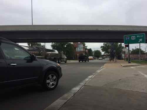
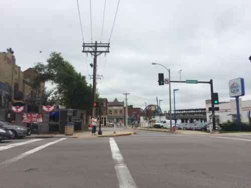
Yesterday’s post was about the bike lanes on Chouteau that aren’t there…yet. While I was photographing the absence of bike lanes late last month I noticed something else as I crossed Chouteau at Tucker. The annoying pedestrian crosswalk buttons aren’t next to the curb ramp where they should be.
I’m at the ramp to cross Chouteau going South, the pedestrian button is on the back side of the silver pole! The visible button the side of the pole to cross Tucker heading East.Looking back North you can see the pole and the ramp at the corner.
Pedestrian buttons should be reachable from the ramp, not 20 feet away! Personally I don’t think pedestrians should have to seek out and press button to get a walk signal — they should be automatic. Imagine driving and having to know just where to stop at a red light to give you a green light.
Pedestrian buttons are great for the sight-impaired. If done properly, once activated, it’ll verbally announce to the user when the walk sign is on and that it’s ok to cross. The rest of us shouldn’t have to press a button to get a walk signal.
Chouteau is maintained by MoDOT, I’ll alert them and the city about this.
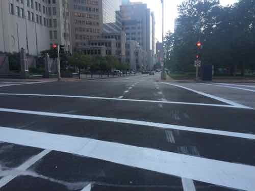
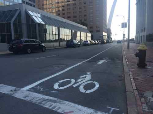
Those of you who follow this blog on Twitter & Facebook know I post a few pics of the new protected bike lane last week. I’d read about it in an article on the 18th or 19th:
The city also announced the addition of its first parking-protected bike lane downtown on Chestnut Street between Fourth and 20th streets. It uses parked cars and flexible posts to separate the cycling lane from the driving lane. A striped buffer painted on the street also creates space between open car doors and the bike lane. (Post-Dispatch)
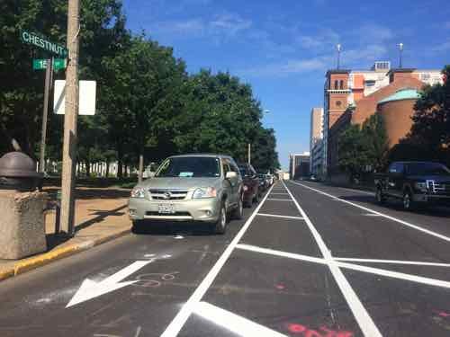
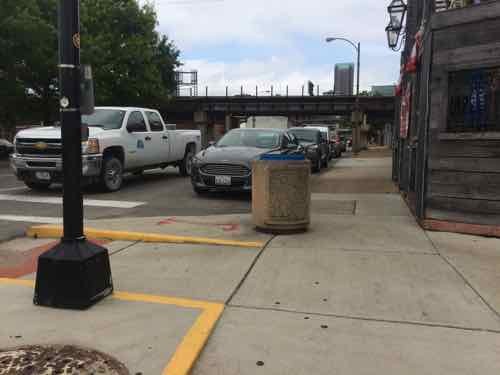
It was a few days before I could get over to Chestnut to see in person, passing by at 15th headed to transit.
On Wednesday July 22 @9;15am I was disappointed to see a long line of cars parked in the bike lane. Traffic Commissioner Deanna Venker told me work wasn’t finished yet.The following morning, Thursday July 23 @ 11am, I was again headed this direction. This time the poles were in place and it was being respected.
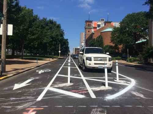
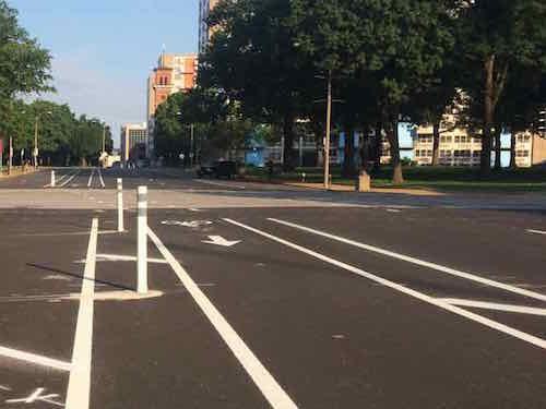
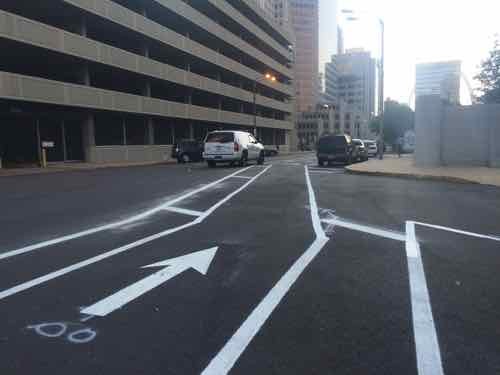
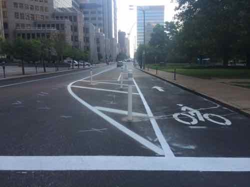
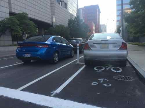
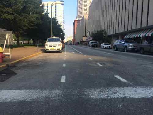
With the bike lane running for 16 blocks, 20th t0 4th, I knew I couldn’t just cross at a single point and expect to understand it. If I wasn’t disabled, biking the mile distance would be the best way to experience it. Friday morning I started at 20th and made my way East to 4th, mostly on the adjacent sidewalk or at crosswalks. Let’s start at 20th:
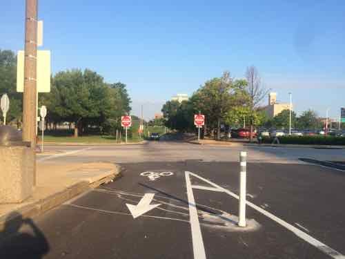
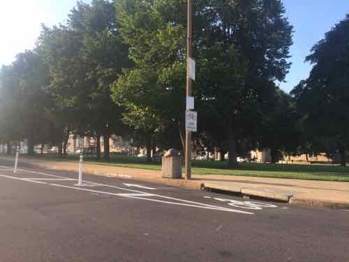
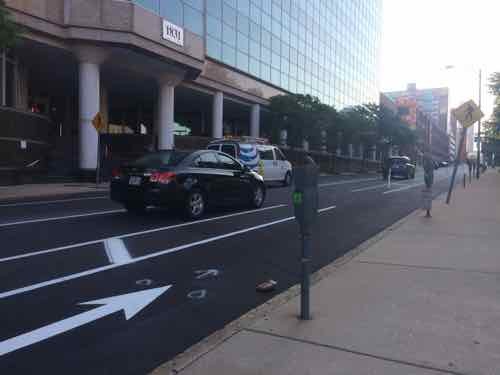
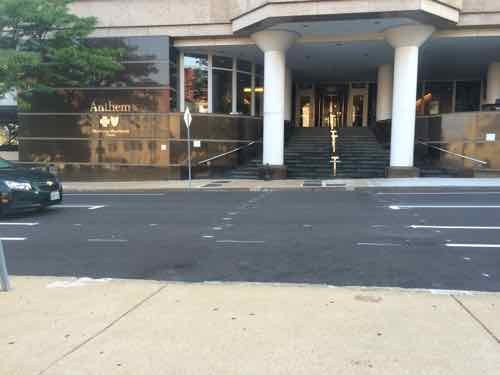
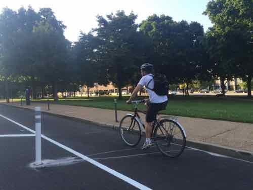
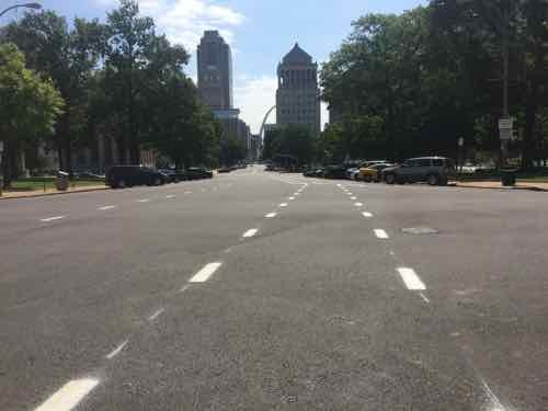
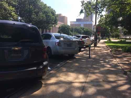
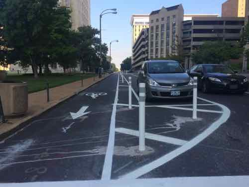
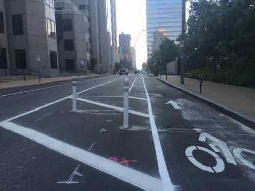
Looking West we see the I-64 off-ramp. A dashed line would help guide motorists to the leftFrom the NE corner, looking SW. toward Aloe Plaza & Union StationA Facebook commenter pointed out many like to load/unload in front of Anthem. If they do now traffic flow will be blockedIt appeared the city plans to paint a crosswalk mid-block, but no curb cuts existAt 18th Street the bike lane remains protected, though drivers & cyclists still need to worry about right-turning cars or left-turning bikes. The city vacated 19th Street decades ago.I saw two different cyclists using the new bike lane during the 45 minutes I was next to itIn this block auto parking is on both sides of a single traffic lane, which the city truck had blocked.At the former 16th Street we see the narrow public walkway, the dashed blue I added shoes that an ADA-conpliant crosswalk is needed here. Click image to see October 2013 post on this subject.Looking East from 15th toward 14th the day before, the angled parking is now back-in style. Auto traffic now has 2 EB lanes.View from the sidewalk, also from Thursday, Back-in parking is safer for cyclists than front-inFriday no cars were parked here, looking West from 14th back toward 15thStill looking West, now from the other side of 14th, we can see the big jog to the left for both cyclists & motorists .Looking West from 13th toward 14thI don’t recall angled parking in front of Soldiers Memorial before
So 20th to 15th is parking-protected, 15th to Tucker (12th) isn’t:
Protected: 5 blocks
Exposed: 3 blocks
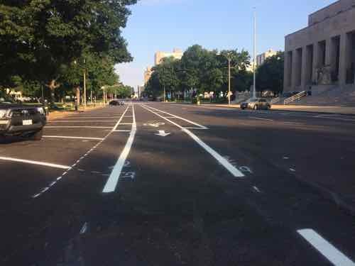
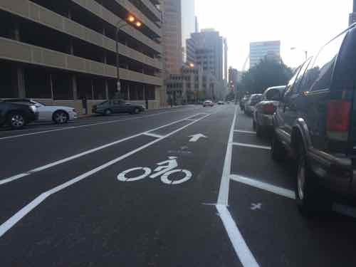
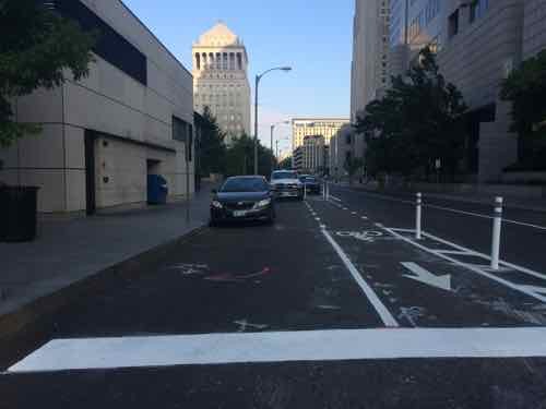
As we continue East across Tucker things get more complicated. Also back to a single lane for vehicular traffic.
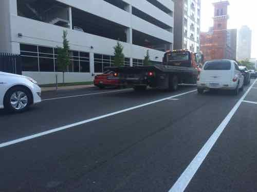
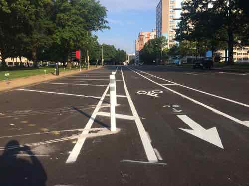
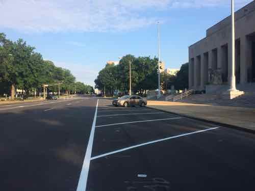
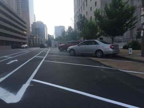
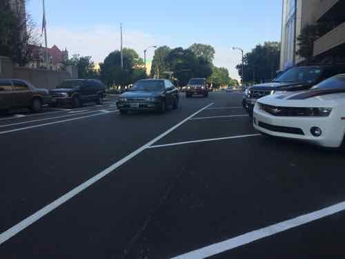
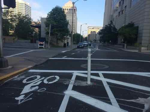
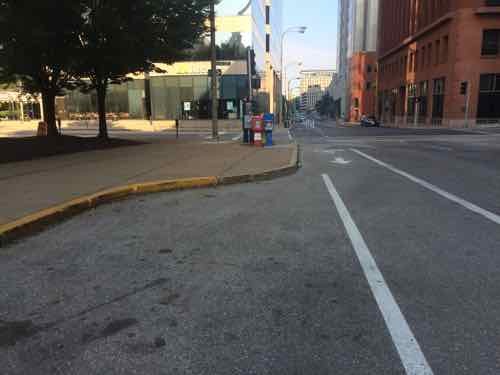
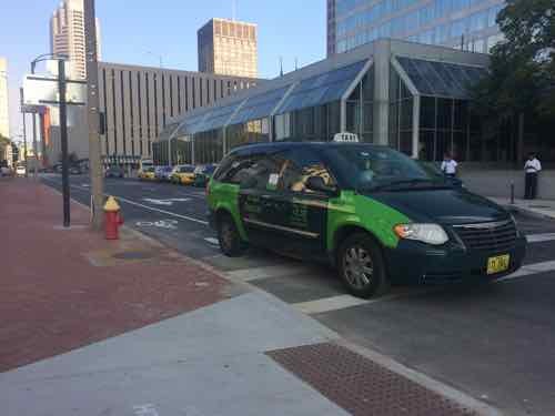
Diagonal back-in parking continues…brieflyThis is probably the single most controversial part of the route, the second half of this block has a conventional exposed bike lane. Hope drivers know to get over to the left.Looking East toward 11th, not sure why the bike lane isn’t on the right side of these parked cars. I see two possibilities: 1) not enough width, and 2) would create an angle crossing 11th.At 11th looking back WestIf more width was needed to protect the bike lane there’s extra on the north side of the streetLooking East across 11th, if the lane on the prior block were protected the angle here would be greater, but still better than the one a half a block backThe lane resumes being protected by parking East of 11th. Twain is on the right,Looking back West from 10thThe first block adjacent to Citygarden is protectedThe 2nd block, East of 9th, starts off protected — but I found a Ford Focus parked in the bike lane. It had two tickets.Looking West from 8th we see the bike lane goes around the delivery area. The white truck belongs to workers on the bike lane.Still looking West, now from the other side of 8th. I’m concerned about vehicles turning right from EB Chestnut onto SB 8th. Will they cut through the delivery area?The block from 8th to 7th is protected by parked cars. I do anticipate problems with people mot seeing disable;ed parking signs, especially back by Tucker. .Curb bulbs are great for pedestrians, bad for protected bike lanes. The last 3 blocks are exposed.Looking West from Broadway (5th), great potential for conflict with right-turning cars.Looking East from Broadway. Why wasn’t the single row of parking placed to protect the bike lane?And finally a taxi that sat in the bike lane through 2 cycles of traffic lights before turning left onto NB 4th
So Tucker to 4th the break down is:
Protected: 3.5 blocks
Exposed: 4.5 blocks
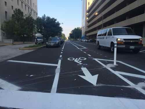
Which gives us totals of:
Protected: 8.5 blocks
Exposed: 7.5 blocks
Of the 16 blocks from 20th to 4th, just over half (53.125%) are protected.
The new white stripes look great against the dark black asphalt, but how will this look in a few years when both fade? I’d like to see the bike half block next to the Civil Courts be protected. When Kiener Plaza gets rebuilt hopefully those two blocks can become protected.
No surprise, but most who voted in the Sunday Poll favored an occupied building to replace a condemned parking garage downtown:
Q: The parking garage at Tucker & Locust, built in 1967, was condemned a few months ago. What should be the long-term outcome? (PICK UP TO 2)
Raze for new building w/zero parking 22 [34.92%]
Raze for new building w/some parking 21 [33.33%]
Renovation of structure, reopen garage 6 [9.52%]
Raze for new parking garage 5 [7.94%]
Unsure/no opinion 3 [4.76%]
Other: 3 [4.76%]
Apartments, parking, ground level retail.
Restaurant
Traditional incremental urbanism
Raze for surface parking lot 2 [3.17%]
Nothing, leave as is 1 [1.59%]
Raze for open space 0 [0%]
I was very happy nobody voted for “Raze for open space”, because we’ve got more open space than we need. I have to wonder about the person who voted that leaving a condemned parking garage is the best long-term outcome. Really!?!
Even in the short-term I’d oppose a surface parking lot. If built properly, it would likely stick around until fully depreciated — which isn’t short-term. We need to build on many of our existing surface lots to reduce holes in our urban fabric. A case could be made for a new parking garage on the site. At this point I’d give little chance the existing garage will be renovated — the repairs are just too costly.Without a doubt, a new building, with or without internal parking, is ideal.
The New Jersey-based entity that owns the condemned garage likely doesn’t care about what’s best for creating a more urban St. Louis, but I don’t care about their bottom line! In the Downtown Neighborhood Association’s Planning & Zoning Committee I’ll advocate for a position on this site that opposes just letting it sit or a surface parking lot, supports a building.
For over a decade I’ve written about pedestrians, including pedestrian deaths. It’s difficult to visit the sites and write about how the area could be designed better, but nothing like the pain experienced by the families & friends who’ve lost a loved one. Most recent was Bapi Gupta:
Gupta’s mother, Genie Dee, and Georgie Busch, who lost her daughter, Amber Wood, in a hit-and-run accident in the same location in 2012, are hoping to bring change to the stretch of roadway.
The string of fatalities and near misses has many calling for slower traffic in the area.
“Why is it 35 miles an hour here? Why isn’t there a stop light up the street here, which they took down, by the way,” said Michael Chekoudjian, the driving force behind a change.org petition asking for changes to the area. (KMOV)
With 3 fast lanes of traffic heading south, trying to beat the lights cars are exceeding the speed limit by 20 to 50 MPH. This is very Dangerous in an “Entertainment District” with as many as a 1000 people in the streets at times and as we know by the hit and run death of “Amber Wood” at the 700 block of Broadway in April of 2012 this is a very dangerous stretch of roadway. We the signers of this petition want Mayor Slay to put a stop to this speeding on this dangerous stretch of road in the name of “Amber Wood” NOW!
First let’s look at a couple of recent suggestions offered by family & friends:
Lower the posted speed limit: Motorists currently exceed the 35MPH speed limit, they’ll drive the same speed regardless of the posted limit. This is because people drive at what they perceive to be a safe speed based on the design of the road. If you want to lower the speed — you must change the design! More on the design later.
Traffic signal at previous intersection: The previous light at Cerre St was removed when a new ramp onto Eastbound I-64 made it a dead-end street. Putting a signal back doesn’t make sense. However, a flashing yellow signal overhead would be a good idea, changing to red if activated by a pedestrian wanting to cross Broadway.
There are things that should change, let’s take a look:
A lot of the traffic on Broadway gets on Westbound I-64 before getting to the commercial district where pedestrians have been struck & killed.Approaching Cerre St from the North.After many get on the highway the remaining traffic now has more room, so they can speed up. Looking South from from just South of Cerre St, three wide traffic lanes in one direction plus parking lanes on both sides. This is designed to move cars quickly, not a good design for the commercial district just beyond the elevated train tracks. The vehicles you see are a deep line stopped at Gratiot St.This is the pedestrian environment across the street from the Broadway Oyster Bar.Looking East at Gratiot St we see the traffic light is green but the pedestrian signal is “don’t walk” Broadway Oyster Bar is on the left. Also not the curb bulbs out into both Gratiot & Broadway.
I sat here for a few cycles to time the lights. For vehicles the light is green for about 38-40 seconds. However, the pedestrian signal is “walk” for just 4 seconds before it begins to flash! It flashes for 10-15 seconds before going to a solid don’t walk, but the traffic signal remains green. Having such a short walk time with a longer traffic time encourages pedestrians to go for it rather than wait on the longer Broadway signal. The pedestrian signal timing needs to change immediately! Ok, let’s cross.
Looking North we see how the “curb bulb” encloses the end of the parking lane on the East side of Broadway, Why wasn’t the curb on the West side bulbed out as well?
Based on my visit, here are my suggestions:
Immediate solutions:
Change pedestrian signal timing at Gratiot.
Short-term solutions:
Reinstall traffic signal at Cerre St., on yellow flash, changing to red if activated by a pedestrian.
Restripe Broadway, narrowing the 3 drive lanes.
Add a solid white lane to separate the outside drive lanes from the adjacent parking lanes.
Change pedestrian signals to have a countdown timer.
Long-term solutions:
New streetscape, putting the road on a diet with curb bulbs at all corners. Include mid-block planters in the parking lanes.
Return 4th & Broadway to 2-way traffic.
More observation, at different times, is needed. But this area must change or we’ll see more pedestrians hit.
AARP Livibility Index
The Livability Index scores neighborhoods and communities across the U.S. for the services and amenities that impact your life the most
Built St. Louis
historic architecture of St. Louis, Missouri – mourning the losses, celebrating the survivors.
Geo St. Louis
a guide to geospatial data about the City of St. Louis