Those of you who follow this blog on Twitter & Facebook know I post a few pics of the new protected bike lane last week. I’d read about it in an article on the 18th or 19th:
The city also announced the addition of its first parking-protected bike lane downtown on Chestnut Street between Fourth and 20th streets. It uses parked cars and flexible posts to separate the cycling lane from the driving lane. A striped buffer painted on the street also creates space between open car doors and the bike lane. (Post-Dispatch)
It was a few days before I could get over to Chestnut to see in person, passing by at 15th headed to transit.
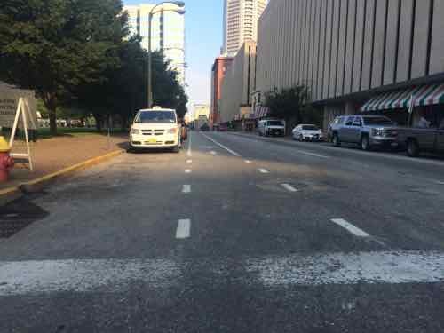
On Wednesday July 22 @9;15am I was disappointed to see a long line of cars parked in the bike lane. Traffic Commissioner Deanna Venker told me work wasn’t finished yet.The following morning, Thursday July 23 @ 11am, I was again headed this direction. This time the poles were in place and it was being respected.
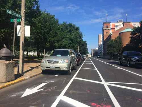
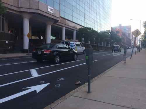
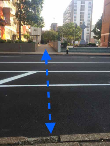
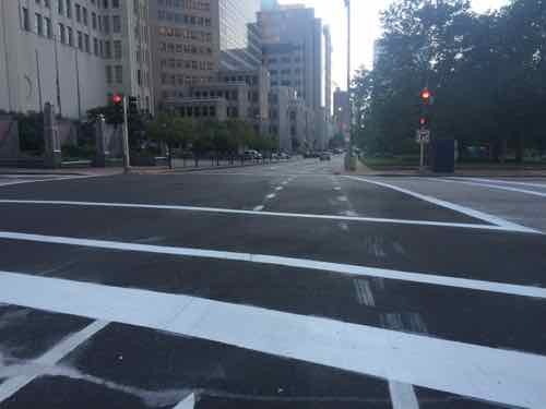
With the bike lane running for 16 blocks, 20th t0 4th, I knew I couldn’t just cross at a single point and expect to understand it. If I wasn’t disabled, biking the mile distance would be the best way to experience it. Friday morning I started at 20th and made my way East to 4th, mostly on the adjacent sidewalk or at crosswalks. Let’s start at 20th:
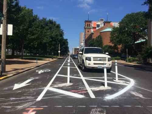
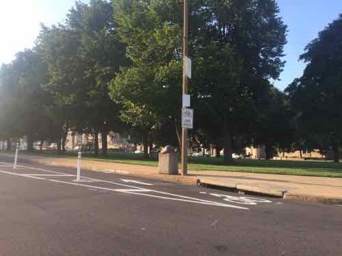
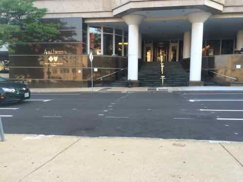
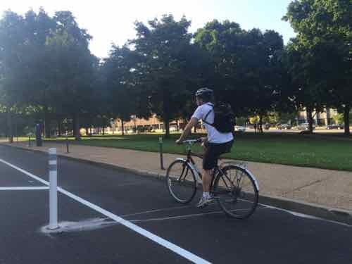
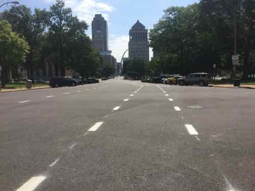
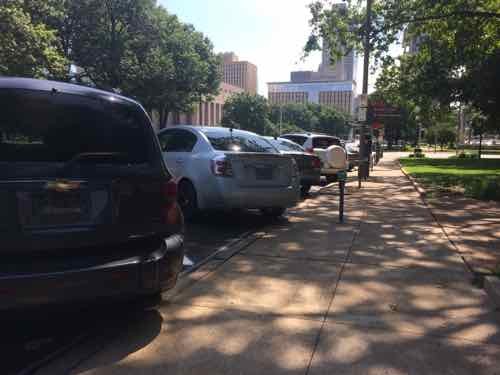
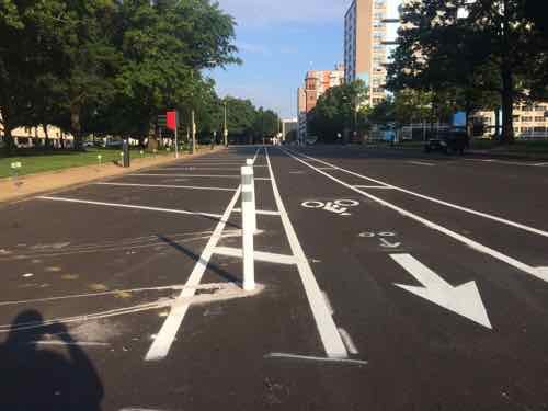
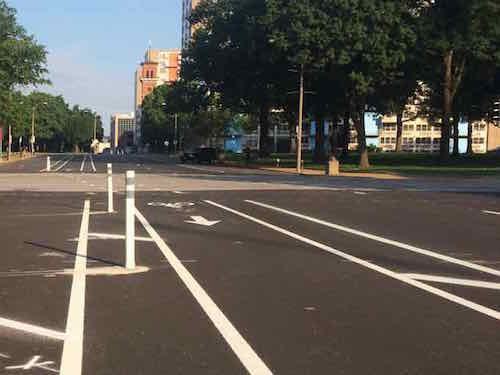
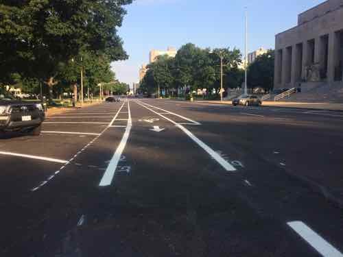
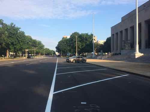
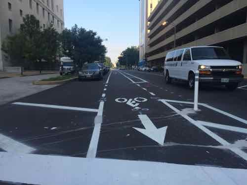
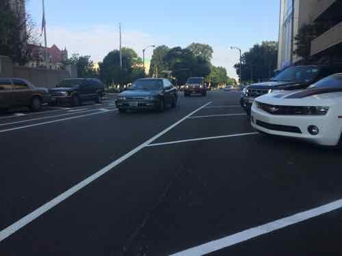
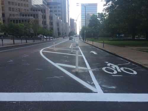
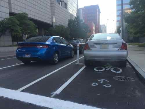
Looking West we see the I-64 off-ramp. A dashed line would help guide motorists to the leftFrom the NE corner, looking SW. toward Aloe Plaza & Union StationA Facebook commenter pointed out many like to load/unload in front of Anthem. If they do now traffic flow will be blockedIt appeared the city plans to paint a crosswalk mid-block, but no curb cuts existAt 18th Street the bike lane remains protected, though drivers & cyclists still need to worry about right-turning cars or left-turning bikes. The city vacated 19th Street decades ago.I saw two different cyclists using the new bike lane during the 45 minutes I was next to itIn this block auto parking is on both sides of a single traffic lane, which the city truck had blocked.At the former 16th Street we see the narrow public walkway, the dashed blue I added shoes that an ADA-conpliant crosswalk is needed here. Click image to see October 2013 post on this subject.Looking East from 15th toward 14th the day before, the angled parking is now back-in style. Auto traffic now has 2 EB lanes.View from the sidewalk, also from Thursday, Back-in parking is safer for cyclists than front-inFriday no cars were parked here, looking West from 14th back toward 15thStill looking West, now from the other side of 14th, we can see the big jog to the left for both cyclists & motorists .Looking West from 13th toward 14thI don’t recall angled parking in front of Soldiers Memorial before
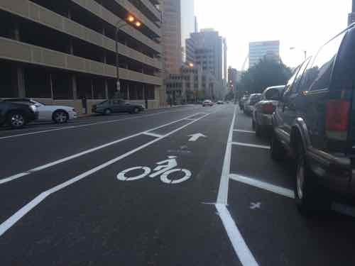
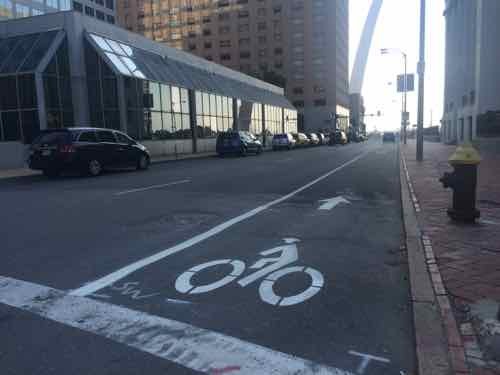
So 20th to 15th is parking-protected, 15th to Tucker (12th) isn’t:
Protected: 5 blocks
Exposed: 3 blocks
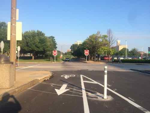
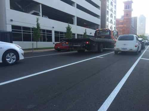
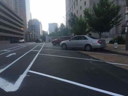
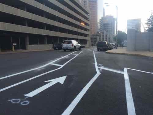
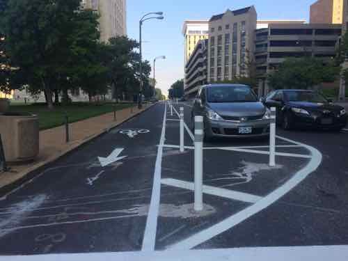
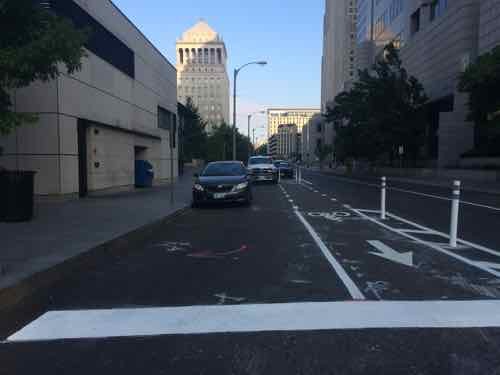
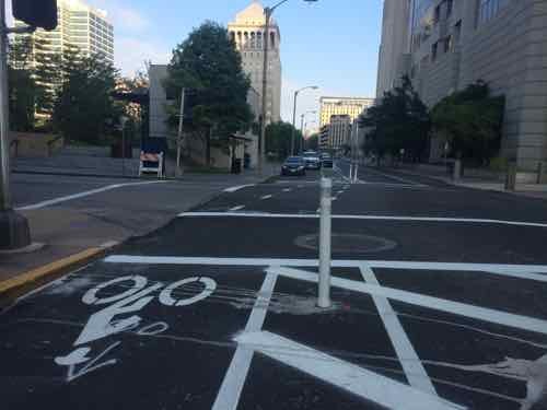
As we continue East across Tucker things get more complicated. Also back to a single lane for vehicular traffic.
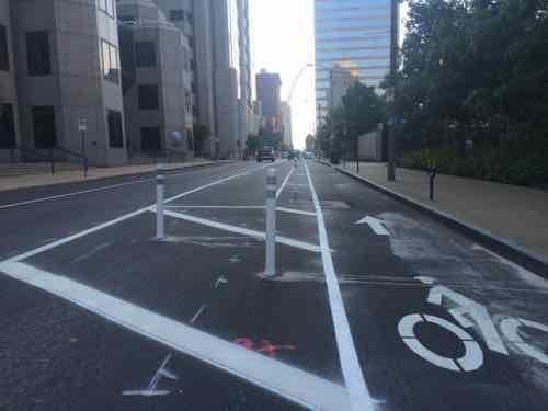
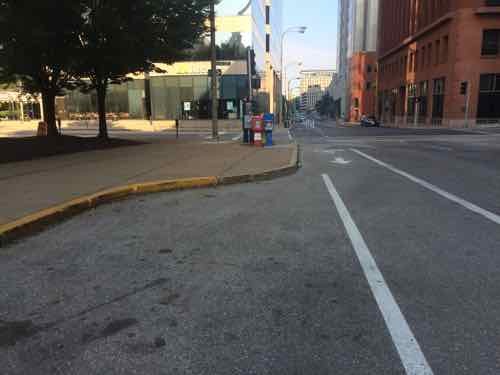
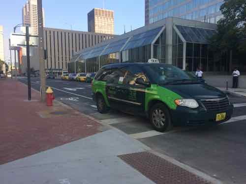
Diagonal back-in parking continues…brieflyThis is probably the single most controversial part of the route, the second half of this block has a conventional exposed bike lane. Hope drivers know to get over to the left.Looking East toward 11th, not sure why the bike lane isn’t on the right side of these parked cars. I see two possibilities: 1) not enough width, and 2) would create an angle crossing 11th.At 11th looking back WestIf more width was needed to protect the bike lane there’s extra on the north side of the streetLooking East across 11th, if the lane on the prior block were protected the angle here would be greater, but still better than the one a half a block backThe lane resumes being protected by parking East of 11th. Twain is on the right,Looking back West from 10thThe first block adjacent to Citygarden is protectedThe 2nd block, East of 9th, starts off protected — but I found a Ford Focus parked in the bike lane. It had two tickets.Looking West from 8th we see the bike lane goes around the delivery area. The white truck belongs to workers on the bike lane.Still looking West, now from the other side of 8th. I’m concerned about vehicles turning right from EB Chestnut onto SB 8th. Will they cut through the delivery area?The block from 8th to 7th is protected by parked cars. I do anticipate problems with people mot seeing disable;ed parking signs, especially back by Tucker. .Curb bulbs are great for pedestrians, bad for protected bike lanes. The last 3 blocks are exposed.Looking West from Broadway (5th), great potential for conflict with right-turning cars.Looking East from Broadway. Why wasn’t the single row of parking placed to protect the bike lane?And finally a taxi that sat in the bike lane through 2 cycles of traffic lights before turning left onto NB 4th
So Tucker to 4th the break down is:
Protected: 3.5 blocks
Exposed: 4.5 blocks
Which gives us totals of:
Protected: 8.5 blocks
Exposed: 7.5 blocks
Of the 16 blocks from 20th to 4th, just over half (53.125%) are protected.
The new white stripes look great against the dark black asphalt, but how will this look in a few years when both fade? I’d like to see the bike half block next to the Civil Courts be protected. When Kiener Plaza gets rebuilt hopefully those two blocks can become protected.
— Steve Patterson
Currently there are "10 comments" on this Article:
This looks unnecessarily complicated to me, especially considering 50% of the route is lightly traveled, as far as “big” cities go.
I understand the reasoning behind protected bike lanes, in that it’s safer for a bicyclist to have cars on one-side of him/her rather than both. But that’s more of an issue in busy areas/cities, which St. Louis’ downtown and downtown west decidedly is not.
To this laymen, it appears you’re further marginalizing bicyclists rights to the road by “hiding” them away behind parked vehicles. I feel the same dedicated bike lane between curb-parked cars and traffic does a much better job of empowering bicyclists and changing the views/actions of drivers as it relates to sharing the road with bicyclists.
– – –
And one quick question for you, Steve — why should a crosswalk be installed mid-block between 15th and 17th on Chestnut? It seems that without adding stop signs there, a crossing would be dangerous. I’m not sure it’s warranted when someone accessing the church or the apartments from the park side can just go up to the existing crosswalks a block in either direction. That, or cross illegally at their own risk. Not really opposed to a crosswalk here, but only if accompanied by stop signs.
Parked cars do a great job of protecting pedestrian on the sidewalk, they do the same for cyclists.
A crosswalk & ramps are needed because 16th remains a pedestrian walkway, used by many. But I and others in wheelchairs can’t cross Chestnut because it lacks ramps. I cross busier streets at crosswalks without stops daily.
I don’t think so. Some pedestrians travel it, sure, and some will/do cross Chestnut illegally to do so, but you commented on your (linked) previous post about this that the City released its rights “decades ago” and it’s no longer public property. So why should the City install a crosswalk guiding people toward what is, for all intents and purposes, just a private path to the Blu condos, accessible from both sides.
Having the parked cars between you and moving traffic is a huge plus. When you are riding with traffic to your left and parked cars to your right, you are threatened both with being smashed by a car (or a bus, which usually come closer) and being doored by a driver leaving his parked vehicle. With cars parked to your left and sidewalk to your right, there’s almost no danger of being smashed, and the risk of being doored is greatly reduced because (1) most cars don’t have passengers and (2) you can bike further away from the parked cars. You’ve got to keep alert for pedestrians stepping into the bike lane, but that’s easier and a lot less stressful.
Finally, I find having these lanes empowering rather than marginalizing,but that’s just my reaction.
This appears to be a well-thought-out solution, for an answer in search of a question. Chestnut was never that intimidating, with or without a bike lane – it’ll be interesting to see how much use it actually gets, including clueless cyclists who will insist on using the new lane to ride westbound!
The real need, especially for serious commuters, is improving bike infrastructure on, and connections to, our many viaducts – Tucker, Jefferson, Grand, Kingshighway, Hampton and Arsenal – all present serious, intimidating “missing links” between south city neighborhoods and the CBD, the central corridor and the CWE. Addressing those will require a similar expenditure of dollars, combined with a much larger expenditure of political will – taking a lane away from Chestnut (or South Broadway) isn’t going to ruffle a lot of feathers. Taking a lane (or two) away from a busy thoroughfare is going to be a much tougher sell- see the continuing pushback from the changes on Manchester.
I agree fully with the need for the connections that you mention. However, in situations like this, where there’s clearly a lot of education that needs to happen (on the part of drivers and bicyclists), it’s sometimes easier to get people accustomed to the general idea. Better to do a pilot first and not immediately put people in danger by retooling busy intersections with completely unfamiliar markings and barriers.
That said, I feel compelled to point out that so many projects (metro-link, proposed downtown trolley line, this bike lane) run east-west. Funny thing is, though, the bulk of the population immediately surrounding the City is north-south. Even if this lane is just a pilot, surely we could have found a not-too-busy north-south route.
South Broadway and 14th Street are currently the best choices for heading south, in my opinion. Both could provide protected bike lanes with some modification.
I think the Chestnut conversion is a good start. I think the next, immediate step would be to convert some lesser-used downtown streets for protected bike travel for west, north, and south-bound bicyclists. Getting people used to it is a good idea, I think.
I appreciated this article. I, too, headed to check out Chestnut when I read the article in the Post-Dispatch. I noted several of the issues mentioned, but not with the detail and thoroughness of the author. Thanks.
Actually, the closer one gets to downtown, thes easier things get, because traffic slows down. The bigger challenges, with intimidating traffic, are outside of downtown. The “lesser-used downtown streets” already work great, for most cyclists, with no further changes.
I don’t disagree. It’s pretty easy to get around downtown wherever the street grid isn’t interrupted. It’s pretty interrupted heading south of downtown and traffic tends to move more quickly on the few streets that provide this connection. That said, I find the City of Saint Louis a very satisfactory place to bike.
AARP Livibility Index
The Livability Index scores neighborhoods and communities across the U.S. for the services and amenities that impact your life the most
Built St. Louis
historic architecture of St. Louis, Missouri – mourning the losses, celebrating the survivors.
Geo St. Louis
a guide to geospatial data about the City of St. Louis


This looks unnecessarily complicated to me, especially considering 50% of the route is lightly traveled, as far as “big” cities go.
I understand the reasoning behind protected bike lanes, in that it’s safer for a bicyclist to have cars on one-side of him/her rather than both. But that’s more of an issue in busy areas/cities, which St. Louis’ downtown and downtown west decidedly is not.
To this laymen, it appears you’re further marginalizing bicyclists rights to the road by “hiding” them away behind parked vehicles. I feel the same dedicated bike lane between curb-parked cars and traffic does a much better job of empowering bicyclists and changing the views/actions of drivers as it relates to sharing the road with bicyclists.
– – –
And one quick question for you, Steve — why should a crosswalk be installed mid-block between 15th and 17th on Chestnut? It seems that without adding stop signs there, a crossing would be dangerous. I’m not sure it’s warranted when someone accessing the church or the apartments from the park side can just go up to the existing crosswalks a block in either direction. That, or cross illegally at their own risk. Not really opposed to a crosswalk here, but only if accompanied by stop signs.
Parked cars do a great job of protecting pedestrian on the sidewalk, they do the same for cyclists.
A crosswalk & ramps are needed because 16th remains a pedestrian walkway, used by many. But I and others in wheelchairs can’t cross Chestnut because it lacks ramps. I cross busier streets at crosswalks without stops daily.
I don’t think so. Some pedestrians travel it, sure, and some will/do cross Chestnut illegally to do so, but you commented on your (linked) previous post about this that the City released its rights “decades ago” and it’s no longer public property. So why should the City install a crosswalk guiding people toward what is, for all intents and purposes, just a private path to the Blu condos, accessible from both sides.
Having the parked cars between you and moving traffic is a huge plus. When you are riding with traffic to your left and parked cars to your right, you are threatened both with being smashed by a car (or a bus, which usually come closer) and being doored by a driver leaving his parked vehicle. With cars parked to your left and sidewalk to your right, there’s almost no danger of being smashed, and the risk of being doored is greatly reduced because (1) most cars don’t have passengers and (2) you can bike further away from the parked cars. You’ve got to keep alert for pedestrians stepping into the bike lane, but that’s easier and a lot less stressful.
Finally, I find having these lanes empowering rather than marginalizing,but that’s just my reaction.
This appears to be a well-thought-out solution, for an answer in search of a question. Chestnut was never that intimidating, with or without a bike lane – it’ll be interesting to see how much use it actually gets, including clueless cyclists who will insist on using the new lane to ride westbound!
The real need, especially for serious commuters, is improving bike infrastructure on, and connections to, our many viaducts – Tucker, Jefferson, Grand, Kingshighway, Hampton and Arsenal – all present serious, intimidating “missing links” between south city neighborhoods and the CBD, the central corridor and the CWE. Addressing those will require a similar expenditure of dollars, combined with a much larger expenditure of political will – taking a lane away from Chestnut (or South Broadway) isn’t going to ruffle a lot of feathers. Taking a lane (or two) away from a busy thoroughfare is going to be a much tougher sell- see the continuing pushback from the changes on Manchester.
I agree fully with the need for the connections that you mention. However, in situations like this, where there’s clearly a lot of education that needs to happen (on the part of drivers and bicyclists), it’s sometimes easier to get people accustomed to the general idea. Better to do a pilot first and not immediately put people in danger by retooling busy intersections with completely unfamiliar markings and barriers.
That said, I feel compelled to point out that so many projects (metro-link, proposed downtown trolley line, this bike lane) run east-west. Funny thing is, though, the bulk of the population immediately surrounding the City is north-south. Even if this lane is just a pilot, surely we could have found a not-too-busy north-south route.
South Broadway and 14th Street are currently the best choices for heading south, in my opinion. Both could provide protected bike lanes with some modification.
I think the Chestnut conversion is a good start. I think the next, immediate step would be to convert some lesser-used downtown streets for protected bike travel for west, north, and south-bound bicyclists. Getting people used to it is a good idea, I think.
I appreciated this article. I, too, headed to check out Chestnut when I read the article in the Post-Dispatch. I noted several of the issues mentioned, but not with the detail and thoroughness of the author. Thanks.
Actually, the closer one gets to downtown, thes easier things get, because traffic slows down. The bigger challenges, with intimidating traffic, are outside of downtown. The “lesser-used downtown streets” already work great, for most cyclists, with no further changes.
I don’t disagree. It’s pretty easy to get around downtown wherever the street grid isn’t interrupted. It’s pretty interrupted heading south of downtown and traffic tends to move more quickly on the few streets that provide this connection. That said, I find the City of Saint Louis a very satisfactory place to bike.