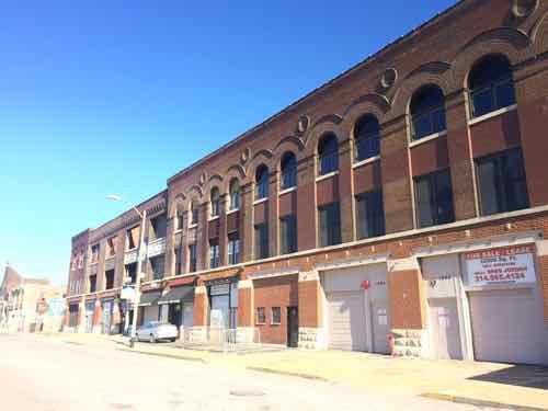
Fifty years ago today the final baseball game was played at Sportsman’s Park, aka Busch I, a site where where baseball had been played since 1867. On May 12, 1966 Busch Memorial Stadium, aka Busch II, opened. St. Louis’ Chinatown, called Hop Alley, was razed to make room for Busch II:
The earliest Chinese settlers congregated in an area stretching East and West between Seventh and Eighth Streets, and North and South between Market and Walnut Streets, which became the Chinatown of St. Louis, more commonly known as Hop Alley. Hop Alley was the name of a small alley running between Walnut and Market Streets where most boarding houses and apartment buildings were occupied by Chinese residents. It is not known how this neighborhood came to be called Hop Alley, but the name was widely used in contemporary newspapers and other accounts to represent the Chinese business district in St. Louis downtown where Chinese hand laundries, merchandise stores, grocery stores, herb shops, restaurants, and clan association headquarters were located. (Journal of Urban History January 2002)
One neighborhood was razed, another lost a major employer. Was it worth it?
This non-scientrific poll is open until 8pm tonight. Thursday I’ll post the results and share my views on the topic.
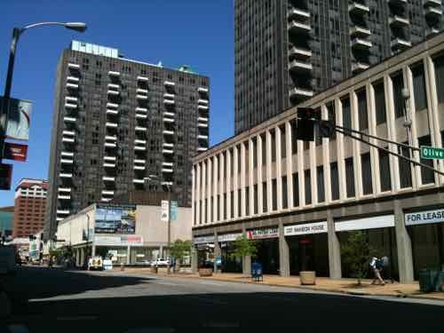
During the Urban Renewal era St. Louis leveled much of downtown — chasing away residents, businesses, shoppers, workers, etc. By the mid-1960s blocks and blocks of once-vibrant land began to get new structures. In October 1965 the top piece of the Arch was set into place. A couple of weeks before Busch Stadium II opened, a new residential project opened: Mansion House Center.
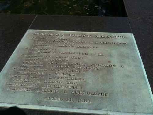
The Mansion House center faces 4th Street, 2011 photoA plaque next to the center fountain lists those involved and the date — April 29, 1966. Photo from April 2011
It was everything good & bad about 1960s modernism. On the plus side it had clean lines and quality materials. On the negative, it rejected the public sidewalk & street grid. Cars stored in the massive, but confusing, garage faced the new Arch. One level up from the public sidewalk, a private promenade level sought to remove residents from the street.
As I’ve said before, the three towers are good. It’s the low-rose platform base & garage that need to be reworked. Olive & Locust need to be reopened. The East face needs to be connected to a future boulevard. The center is divided among multiple owners, so the likelihood of a project to undo the anti-city aspects is slim.
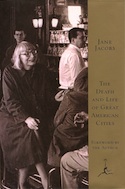
Ten years ago today, one of my heroes died. Jane Jacobs, author of The Death & Life of Great American Cities, was 89. Her 1961 classic was a sharp critique of Urban Renewal — the erase & replace thinking that was commonplace at the time. New York’s Robert Moses & St. Louis’ Harland Bartholomew were among the top advocates of Urban Renewal.
At 45, she and many others directly challenged Moses’ plan to cut an interstate highway through lower Manhattan:
Jacobs chaired the Joint Committee to Stop the Lower Manhattan Expressway (a.k.a. Joint Emergency Committee to Close Washington Square to Traffic, and other names), which recruited such members as Margaret Mead, Eleanor Roosevelt, Lewis Mumford, Charles Abrams, and William H. Whyte. Papers such as The New York Times were sympathetic to Moses, while the newly created Village Voice covered community rallies and advocated against the expressway. The Committee succeeded in blocking the project. On June 25, 1958, the city closed Washington Square Park to traffic, and the Joint Committee held a ribbon tying (not cutting) ceremony. Jacobs continued to fight the expressway when plans resurfaced in 1962, 1965, and 1968, and she became a local hero for her opposition to the project. She was arrested by a plainclothes police officer on April 10, 1968, at a public hearing, during which the crowd had charged the stage and destroyed the stenographer’s notes. She was accused of inciting a riot, criminal mischief, and obstructing public administration – after months of trials conducted in New York City (to which Jacobs commuted from Toronto), her charge was reduced to disorderly conduct. (Wikipedia)
Following her arrest, and in protest of the U.S. involvement in the Vietnam War, she, her husband (an architect) and two draft-able sons, moved to Canada. They settled in Toronto.
A few months after her death, I was in standing in front of the home where she lived in Toronto. Crying.
The following are some videos about her, some of her speaking.
Jacobs still inspires me today, I just wish I’d known of her in high school — I would’ve studied urban planning instead of architecture, in the mid-late 1980s. May 4th will mark the 100th anniversary of her birth.
The redevelopment process commonly known as Urban Renewal, in retrospect, was largely a failure:
After World War II, urban planners (then largely concerned with accommodating the increasing presence of automobiles) and social reformers (focused on providing adequate affordable housing) joined forces in what proved to be an awkward alliance. The major period of urban renovation in the United States began with Title I of the 1949 Housing Act: the Urban Renewal Program, which provided for wholesale demolition of slums and the construction of some eight-hundred thousand housing units throughout the nation. The program’s goals included eliminating substandard housing, constructing adequate housing, reducing de facto segregation, and revitalizing city economies. Participating local governments received federal subsidies totaling about $13 billion and were required to supply matching funds.
Sites were acquired through eminent domain, the right of the government to take over privately owned real estate for public purposes, in exchange for “just compensation.” After the land was cleared, local governments sold it to private real estate developers at below-market prices. Developers, however, had no incentives to supply housing for the poor. In return for the subsidy and certain tax abatements, they built commercial projects and housing for the upper-middle class. Title III of the Housing Act of 1954 promoted the building of civic centers, office buildings, and hotels on the cleared land. Land that remained vacant because it was too close for comfort to remaining slum areas often became municipal parking lots. (source)
Jane Jacobs’ 1961 book The Death and Life of Great American Cities rebuked the ongoing land clearance policies advocated by supporters of urban renewal. By the late 1960s one of St. Louis’ most prominent urban renewal projects — Pruitt-Igoe — was a disaster. Before the 20th anniversary the first of 33 towers were imploded in 1972 — urban renewal was unofficially over.
In 1974 it was officially over:
The Housing and Community Development Act of 1974 emphasized rehabilitation, preservation, and gradual change rather than demolition and displacement. Under the Community Development Block Grant program, local agencies bear most of the responsibility for revitalizing decayed neighborhoods. Successful programs include urban homesteading, whereby properties seized by the city for unpaid taxes are given to new owners who promise to bring them “up to code” within a given period—either by “sweat equity” (doing the work themselves) or by employing contractors—in return for free title to the property. Under the Community Reinvestment Act, lenders make low-interest loans to help the neighborhood revitalization process. (same source as first quote)
But forty plus years later the St. Louis leadership continues as if nothing changed. The old idea of marking off an area on a map to clear everything (homes, schools, businesses, churches, roads, sidewalks) within the red lined box remains as it did in the 1950s. The message from city hall is clear: don’t invest in North St. Louis because they can & will walk in and take it away.
Great old building near Cass & Jefferson would be razed for the campus
What are the scenarios at this point?
A) National Geospatial-Intelligence Agency selects the city option:
Businesses, residents, churches, etc are displaced.
A 100-acre swath is purchased and cleared.
The federal government builds a fortress-like campus, few workers would leave at lunch.
No benefit to the surrounding neighborhoods, access to public transit cut off by monolithic campus.
Adjacent areas now threatened as the next target for clearance, further eroding those areas.
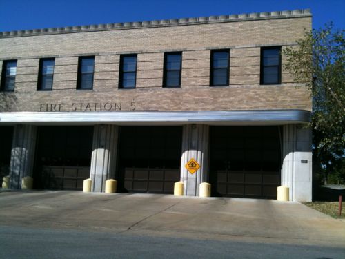
Fire Station Number 5 would remain, but because of the new campus, firefighters would be unable to quickly reach the area to the West of Jefferson/Parnell.
Fire Station 5, in the narrow strip between St. Louis Place Park and the proposed campus, would be blocked to the West.
B) National Geospatial-Intelligence Agency selects another option:
Nobody buys into this area because it’s now a known target area.
It declines further because it’s a known target area.
It’s taken later for some corporate campus.
C) An alternative if National Geospatial-Intelligence Agency selects another option:
The city/community works with Paul McKee, existing businesses and property owners to develop a plan to revitalize the Cass & Jefferson/Parnell corridors and to coordinate with a new street grid in the long-vacsnt Pruitt-Ogoe site.
The existing street grid is left fully intact.
Infill planned with a variety of residential units with a concentration of retail & office at Cass & Jefferson.
But this won’t happen, St. Louis is forever stuck in the middle of the 20th century. Clearance for a new stadium and a QuikTrip are other current examples. It has been nearly 70 years since St. Louis adopted Harland Bartholomew’s City Plan and we’ve yet to stray from the thinking he outlined.
Q: Should the City of St. Louis use eminent domain powers to assemble a site if the National Geospatial-Intelligence Agency selects the city option?
No 20 [44.44%]
Yes 14 [31.11%]
Maybe 8 [17.78%]
Unsure/No Opinion 3 [6.67%]
We shouldn’t be willing to raze 100 acres to retain earnings tax revenues. If there was hope the campus would help the surrounding area it might be a fair tradeoff, but it’ll further deteriorate and isolate. Still, this urban renewal mindset is so engrained I’m not sure we’ll ever break free of it.
The Rams Task Force unveiled its proposal for a new open-air stadium in downtown St. Louis last Friday:
The proposed location of the new stadium is on the North Riverfront, adjacent to Laclede’s Landing, sitting on over 90 acres of privately and publicly owned property. The completion date would be set no later than 2020. (KSDK)
The reactions to Friday’s announcement of a proposal for a new stadium were swift and varied; some liked it, others habte it. It was suggested it’ll never happen, it’s just a way for politicians to say they tried their best to keep the Rams from leaving or Kroenke is set on LA, he’ll never go for it. Unlike when we failed to get an NFL expansion team and we had to attract an existing team, now all we need to do make the proposal attractive enough so the NFL owners don’t vote to allow the Rams to leave — except that Kroenke seems willing to build a new LA stadium, move the team, and fight his fellow NFL owners in court. The truth is likely a combination of all these.
Rather than rush out a post, I wanted to visit the area again in person before putting my thoughts down. My previous visit was in May 2012, passing through on Amtrak.
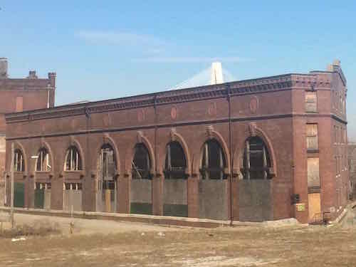
The Cotton Belt is listed on the National Register of Historic Places, click image to see nomination.
Hopefully this won’t go forward, but we must act as if it will to help block it.
Proposed stadium not within the CBD (Central Business District): I’ve been posting for years that NFL has no place in a CBD, they play too few games and the tailgate tradition means surface parking — both bad if you desire a 24/7 downtown. For these reasons, other cities have placed their stadiums just outside their CBD
Recognition of need to connect two areas long separated by highway: Two long-neglected areas on each side of I-44, previously I-70, each need investment and access to each other.
Open-air, dual use for soccer: Open air is much nicer than dark and closed (EJD), weather permitting. Major League Soccer (MLS) is expanding, we could get an expansion team if we build a stadium. This sounds vaguely familiar…
Bad use of public resources, see Nicklaus: Stadium may sparkle, but it’s not an investment: “St. Louis is being asked to pay dearly for the prestige of remaining an NFL city, so I think Peacock described his stadium plan accurately when he called it a “crown jewel.” A jewel can sparkle and make its owner feel good, but it’s hardly a productive use of half a billion dollars.”
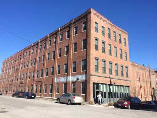
Would destroy recently completed (April 2013) $10 million+ transitional housing project called Stamping Lofts, halt plans for future phase to create urban farming jobs know as FarmWorks.
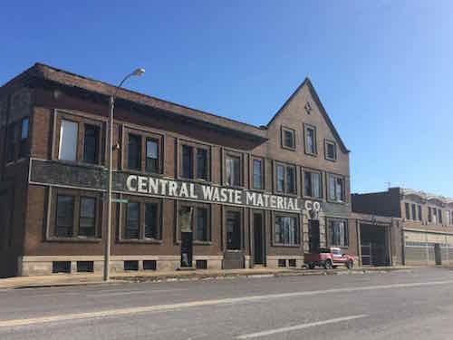
Would destroy the unique Cotton Belt building (shown above), individually listed on the National Register of Historic Places for over a decade.
Would destroy the William Kerr Foundation building, a state of the art green building.
Would destroy numerous vacant warehouses that could be used for offices and/or residential.
Would force numerous businesses to close or relocate.
The railroad isn’t likely to agree to routing their track to the West of this new stadium, in a ditch. Leaders must’ve forgotten about the legal battles won by the railroad when designers want the track moved for the Arch, see tunnel.
Although MetroBus service exists, light rail isn’t close.
Let’s take a look:
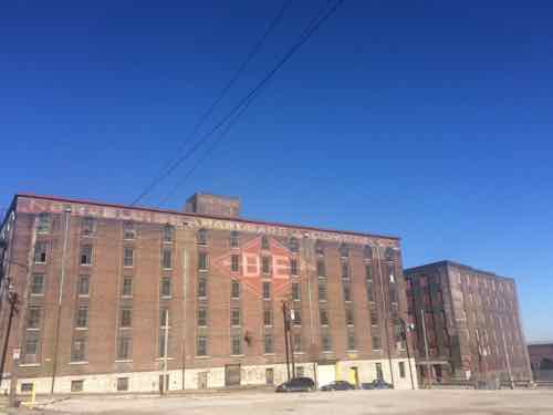
The Laclede Power building, just North of the Ashley Street Power House, a contributing building in the North Riverfront Industrial Historic District, would be razed. Considerable money has been spent over the years to stabilize the building so it might be rehabbed in the future.Warehouses, contributing buildings in the North Riverfront Industrial Historic District along Ashley St between 2nd and Lewis.These buildings along North Broadway are the main part of the Wholesale & Warehouse Historic District, the Shady Jacks Saloon is located in partThese buildings are part of the same district on the National Register.After a $10 million dollar investment, the Stamping Lofts opened in April 2013. Also part of the same historic district.
For years now this area has been coming together, with two National Register historic districts and one individually-listed building, substantial investments have been made to numerous buildings as a result. Don’t our leadership care about the investments, businesses, and year-round jobs? Sadly, as I pointed out yesterday, St. Louis began planning to raze a hotel less than a decade after it opened.
It also seems like every decade our leadership wants to raze a historic building — this would let them take away two entire districts and an individually-listed building. It’s been just over a decade since the wrecking ball began taking down the Century Building, so they’re on schedule I suppose. This area is also likely targeted because the owners of Lumière Place Casino and Hotels and Bissinger’s don’t like the rest of the area between them.
I’ll end with an open note to Rams owner Stan Kroenke:
Mr. Kroenke:
There are lots of large vacant sites in the St. Louis region where you could build a stadium. I say you build it because you’re a real estate developer, you know the value of owning the real estate. More importantly, I want you to own any new stadium so you’ll reinvest your profits in it as you see fit, also making it harder to walk away in 10-20 years.
You can do something else with your property in Inglewood, CA, but I think you already know prime property like that has many potential projects. Hell, build a stadium on it for another NFL team. But please, don’t accept the task force proposal — we’d lose too much and gain…more public debt.
So build elsewhere in the region or move the team back to LA!
AARP Livibility Index
The Livability Index scores neighborhoods and communities across the U.S. for the services and amenities that impact your life the most
Built St. Louis
historic architecture of St. Louis, Missouri – mourning the losses, celebrating the survivors.
Geo St. Louis
a guide to geospatial data about the City of St. Louis