When St. Louis opened the Cervantes Convention Center in 1977 it had an adjacent convention hotel, a Sheraton, at 7th & Cole. Almost immediately talk of expanding the convention center was underway. The city had two options — go east of 7th Street or South of Delmar (renamed Convention Plaza). The convention center is now called America’s Center.
One problem with expanding the convention center to the East was the nearly new, 600+ room, Sheraton hotel that also opened in 1977.
From the St. Louis Post-Dispatch from Thursday, March 10, 1988:
If St. Louis follows through on its offer to buy and demolish the Sheraton St. Louis Hotel just east of the Cervantes Convention Center, the convention center could be left with a marketing nightmare, hotel industry insiders say. Razing the 614-room Sheraton to expand the convention center would leave the convention center, at least temporarily, without a hotel on the site that is large enough to handle visitors.
The city offered Monday to buy the Sheraton and other land east and south of the convention center to make way for a 120,000-square-foot expansion. Officials declined to disclose the amount of the offers. Hotel and real estate sources estimate that the Sheraton could be worth anywhere from $25 million to $40 million, but city officials said those estimates were high.
By May 1988 the city looked toward the South rather than the East:
There are several good reasons for the city to have changed directions on the Convention Center expansion and go southward to Washington Avenue instead of eastward across Seventh Street. A Convention Center fronting on Washington would remove an eyesore and contribute significantly to the revitalization of the street. It will thrust the center into downtown, whereas the eastward expansion would have left it on the periphery. Finally, it solves the problem of the Sheraton Hotel, east of the center. Under one scheme, the center was to be built around the hotel. Under another, the hotel was to be demolished. Neither approach was satisfactory.
The Convention Center is on Convention Plaza, better known as Delmar Boulevard, and is bounded by Seventh and Ninth streets. Under the latest expansion plan, Dillard’s parking garage and the Lennox Apartments would be spared but the other structures between Seventh and Ninth would go. The southward expansion would add 120,000 square feet, as would have the original plan. The cost, $72 million, will be about the same. The tourism industry is important to the economy of the region and the state. The expansion of the Convention Center will assure that the area will be able to attract large meetings that otherwise would go elsewhere [Source: St. Louis Post-Dispatch – Saturday, May 21, 1988]
The Sheraton hotel, just over a decade old, was spared demolition – for now at least.
Earlier in 1988 the football Cardinals announced plans to leave St. Louis for Arizona because St. Louis wouldn’t build them a stadium. The Cardinals had played football in Busch Stadium since it was built in 1966. I’m not sure where they played 1960-66. The team wanted a football stadium, not a shared baseball stadium.  The new stadium debate had already gone on for a couple of years before the Cardinals left. As soon as they announced they were packing their bags for Arizona the efforts to built a stadium and attract a new team gained speed. Soon the idea of expanding the convention center to the South with the stadium going East emerged.
From the St. Louis Post-Dispatch on Friday, December 14, 1990:
The Sheraton St. Louis hotel downtown is scheduled to close the first week of January [1991], idling about 300 workers and leaving the city without a major convention headquarters. Officials of the two unions that represent the employees were formally notified Thursday morning. The hotel lies in the path of the eastern expansion of the Cervantes Convention Center, a $250 million project that includes a domed stadium. The hotel will be torn down, but no date has been set for the demolition. Management of the Sheraton had expected to operate the hotel until construction of the stadium began. Until the last few days, the hotel was accepting reservations through 1991.
Late in 1987, city officials first publicly discussed an eastern expansion of the convention center. From that moment on, hotel industry sources say, the Sheraton has seen an erosion of bookings. It has always depended on group business, which is usually arranged two to four years in advance.
The best way to ruin a business is to threaten to take it away. Talk of razing a building a decade later. Smart. Taking out your convention hotel to expand your convention center, even smarter.
P-D on Tuesday, July 14, 1992:
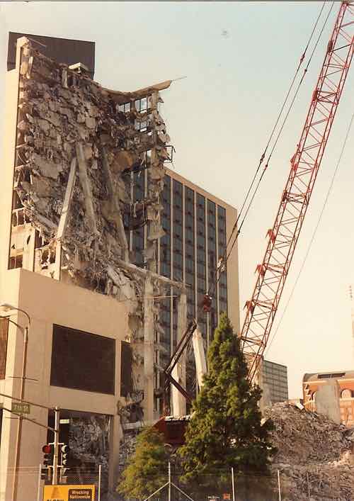
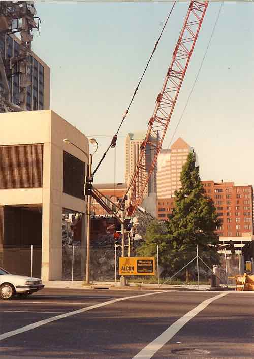
As politicians smiled and sweated in Monday morning’s 89-degree heat, ground was broken for the $260 million stadium expansion of Cervantes Convention Center. The building, scheduled for completion by October 1995, will seat 70,000 for professional football. With 177,000 square feet of exhibit space on one level, it will accommodate events as large as national political conventions. During the hour-long ceremonial groundbreaking at Seventh Street and Convention Plaza, demolition crews began swinging a giant ”headache ball” at the old Sheraton Hotel, one block north. Each swipe at the 13-year-old hotel, which sits near the 50-yard-line of the stadium expansion, brought cheers. But the sturdily built hotel was slow to succumb to the headache ball.
It took a while to raze the nearly new structure. I recently found a couple of photos I had taken:
July 1992July 1992 — looking South from Cole & 7th
The expansion & dome were completed. St. Louis was not awarded an expansion team. Instead the Rams relocated from Los Angeles, California. It was not until 2003, over a dozen years later, that the Renaissance Grand & Suites opened to replace the loss of the Sheraton. Conventions expected by the expansion didn’t come due to the lack of a convention hotel. Brilliant!
Of course the Renaissance Grand convention hotel has had it’s own issues, from earlier this year:
The Renaissance Grand Hotel & Suites is set to be auctioned off Feb. 2 at the St. Louis Civil Courts Building, 11th and Market streets.
Since the hotel’s opening, it has repeatedly not generated enough revenue to cover its twice-yearly interest payments due on its $98 million debt load. New Orleans-based HRI Properties developed the hotel and is an owner. [Source: St. Louis convention center hotel headed for foreclosure, January 14, 2009]
Each decade the numbers get bigger and bigger. We had a convention hotel, then we didn’t and then we did again. The most jobs created through all this were for demolition companies and consultants.
General Motors is expected to file for bankruptcy protection today.
The GM that helped move the world from horses to Chevys and Cadillacs is expected to file for bankruptcy protection Monday. The new GM that emerges sometime in the future will be leaner — unsaddled from much of its debt and labor cost disadvantages that contributed to tens of billions of dollars of losses. It will also be almost three-quarters owned by U.S. taxpayers. Source: AP/USA Today
But GM’s headquarters can’t be made leaner as easily.
Above: GM's Headquarters, July 2006
I saw GM’s Renaissance Center, now branded as Ren Cen, in 2006 while returning to the U.S. from a vacation in Canada The iconic headquarters gleamed in the sunlight but failed to impress me. It symbolizes the old GM — bigger than life, too big in fact. Disconnected. It is like tail fins on a Cadillac in an era of Honda Accords.
The history is interesting, starting life with Ford, not GM:
On November 24, 1971, Henry Ford II, then chairman of the board of directors of Ford Motor Company, announced the Renaissance Center project to the Detroit Common Council. One year later, site clearance for the Center began. On July 1, 1976 the first office tower (Tower 100) was opened. A formal dedication was held on April 15, 1977 for the four, 39-floor office towers and the 73-story hotel.Renaissance Center Phase II, Towers 500 and 600, was opened in 1981, as a separate venture developed by subsidiaries of Ford Motor Land Development Corporation and Rockefeller Center, Inc. and purchased by ANR Ren-Cen, Inc. in 1984.
On May 16, 1996, General Motors announced the purchase of the Renaissance Center for use as its global headquarters and later announced a $500 million renovation of the Center. The GM Renaissance Center is now home to more than 6,000 GM workers and 4,000 Center tenant employees.
The total square footage of the GM Renaissance Center is 5.5 million. The office towers include 2.2 million square feet of space; 230,000 square feet is dedicated to retail space. The Marriott Detroit at the Renaissance Center is one of the tallest hotels in the world with 1,298 guest rooms.
Construction on the Ren Cen began May 22, 1973 (Phase I).
Project architects were by John Portman & Associates.
The Ren Cen has its own zip code – 48243.
The GM Renaissance Center sits on 14 acres.
There are four 39-story towers (508’ high each).
The 73 story 1,298 room hotel (Marriott) is 726’ high and 188’ in diameter.
There is a 5-story glass enclosed atrium (GM Wintergarden).
There is a 12 ft. wide glass circulation walkway with access to all four towers (for exercise purposes, you need to walk around 8 times for one mile). Source: gmrencen.com
Like so many projects of the era, the large site was cleaned and started over. Shedding the past, like bankruptcy. But in the urban renewal version the result is bloated and detached.
Source: gmrencen.com (click image to view)
The headquarters isn’t fully to blame for the disconnected from Detroit. I-375, also known as the Chrysler Expressway, does a good job of separating Detroit from it’s waterfront.
The U. S. auto industry is getting a long overdue overhaul. New emissions standards will alter the automobiles we see in the future. Cities too are slowly undoing past urban renewal mistakes. The scale of GM’s Renaissance Center means it will likely be with us long after the new GM emerges from bankruptcy. How unfortunate.
My intent for today was to summarize Paul McKee’s development proposal being dubbed ‘NorthSide.’Â In starting to write that piece it became clear I needed to build a foundation on the origins of the current problems in North St. Louis. So today I take you through decisions from the 20th century that got us to where we are and tomorrow I’ll give you my thoughts on McKee’s proposal.
North St. Louis has many great streets, buildings and people. But it has as many streets that are largely abandoned, buildings barely standing, vacant lots and criminally minded youth.  It is known more for the latter than the former.
Above: North St. Louis property in August 2007
When I moved to St. Louis in August 1990. at age 23, I was told not to go North of Delmar Blvd. — the long dividing line between white and black St. Louis. I ignored the advice, however well-intentioned, from the 50-something apartment manager and went North of Delmar. The following year I moved to the Old North St. Louis neighborhood. But how did this dividing line come to exist? For the answer we need to start way back in 1917.
Harland Bartholomew came to St. Louis in 1916, at age 27, after working briefly in Newark, NJ as an employee of civil engineers E.P. Goodrich & George Ford. Bartholomew was the first municipal planner in the country. Yes, St. Louis was the leading edge for planning at the time. Of course, planning as a profession was just getting started. The 1910 Census was 557,238.
Upon his arrival Bartholomew located his family in a relatively new house on Goodfellow near Page (map). Although within the city’s limits, it was very suburban relative to the older parts of the city near the Mississippi River. His 1917 report, The Problems of St. Louis, shows his dislike of the older sections of the city surrounding downtown.
Above: 1917 book, click to view book
From the above:
The problems of St. Louis are briefly as follows :
(1) Restoration of districts wherein values and occupancy are at a low ebb to a greater degree of usefulness and productivity.
(2) Perfection of transportation and transit systems to make possible the use of property within the zone of the city’s influence, now inaccessible,
(3) Extension of the city limits, or power of the city, to secure greater uniformity and permanency of development.
(4) Provision for public works and service sufficiently far in advance to preclude undue delay and excessive expense.
The problems then are still the problems today. Bartholomew spent the next 30 years telling the city how bad the older areas are. Bartholomew, for example, convinced voters to approve fund measures to widen many streets which involved cutting off the fronts of many buildings, see The History of the Ubiquitous Building Setback Line.  Jane Jacobs in her 1961 classic The Death and Life of Great American Cities called such funds “cataclysmic money.” The Census count was 772,897 by 1920, 821,960 by 1930 and, a down a bit to 816,048 in 1940.
In 1947 Harland Bartholomew, now nearly 60, authored the Comprehensive City Plan which considered much of the city, North & South, “obsolete” or “blighted:”
1947 "Obsolete" (black) & "Blighted" (red) map.
In the above image North St. Louis is on the right. Delmar runs top to bottom a bit right of center. Clearly much of the city, mostly white, was labeled obsolete & blighted. But what did that mean?
Obsolete Areas
Present obsolete areas must be cleared and reconstructed. This is a social necessity as well as an economic essential. The City of St. Louis cannot continue to thrive and prosper where there is nothing but progressive decadence in its housing supply, any more than is could with polluted water supply or smoke laden air.
The unit area for reconstruction must be the neighborhood. It is necessary to create a new environment. This can be accomplished only by large scale operations. Obsolete neighborhoods must be rebuilt, not merely with houses of good design and construction, but with more open space, more park and playground facilities, a good school and community center.
The new Constitution of Missouri authorizes cities to clear obsolete areas and to sell or otherwise dispose of the property, as well as to replan, reconstruct, or redevelop such cleared areas. The new Constitution also authorizes the General Assembly to provide by law for partial relief from taxation for not to exceed 25 years for projects designed for the reconstruction or redevelopment of obsolete areas. A newly enacted Urban Redevelopment Corporation Act now provides for substantial tax relief for reconstruction projects. It should make possible considerable large scale reconstruction.
The Legislature has not enacted legislation which will permit St. Louis to undertake public housing projects of the type heretofore financed with Federal funds. Such legislation is imperative if St.Louis is to participate, as do other American cities in any future Federal public housing programs.
Present high costs of building construction together with rent controls preclude immediate reconstruction of obsolete areas, either for public or for private housing. As construction costs become lower the city must be in a position to encourage wholesale reconstruction of these obsolete areas. This can be achieved by public acquisition of land so that it could be made available for housing and other needed purposes if private acquisition and construction fails to accomplish the needed results. The total cost of clearance would scarcely exceed public expenditure during the past 25 years for other types of public work such as streets, sewers and airports. Unlike these, however, ownership of the land would be a sound investment. The land could be leased or sold, and much if not all of the expense involved could be recovered by (1) elimination of the present $4,000,000 annual deficit, (2) a long-term increment in taxable revenues on private housing projects, and (3) participation in Federal subsidy programs.
Plate Number 15 is a suggested plan for reconstruction of two extremely obsolete neighborhoods-DeSoto and Carr Neighborhoods. This plan calls for reconstruction of these neighborhoods, except for the present Carr Square Village, into super residential blocks with a revised street system that would recognize this block type of development and discourage through traffic; Fourteenth Street, Eighteenth Street, Twentieth Street and Jefferson Avenue would be widened while Cass and Franklin Avenues would remain as they are. Further proposals call for the grouping of commercial areas into designated shopping centers; the erection of two or three story row type apartment buildings generally except for a few multi-story apartment buildings; the erection of two new schools one east of Jefferson and the other between 18th and 20th at O’Fallon; the continuance of certain unobjectionable industries, the enlargement of Carr Park adjacent to Carr School; the development of DeSoto Park for active sports, swimming and as a community center; the enlargement of Murphy Playfield adjacent to the Carr Neighborhood on the north and the provision for landscaped areas throughout the community for passive recreation.
The effectuation of this plan would result in a good standard of housing with ample open space, freedom from multiplicity of small streets, attractive environment, small concentrated shopping areas, and a large neighborhood park and community center would replace one of the worst slums in the city. This is an area occupied by low-income families, many of whom should be rehoused here.
Plate Number 16 is a plan for the reconstruction of the Soulard Neighborhood. Some of the more important features of the plan are: the extension of Gravois Avenue from Twelfth Street to the proposed Third Street Interstate Highway, providing a direct route to the central business district; the widening of 18th Street, the widening and extension of 14th Street, the widening of Park and Lafayette Avenues; underground garages in the multi-storied apartment area between 12th and 14th; a neighborhood part of 10 acres or more complete with spray pool, community facilities and game courts; the extension of Lafayette Park to serve this as well as other neighborhoods; landscaped areas throughout the community for passive recreation; enlargement of the City Hospital area; grouping of commercial areas into orderly shopping centers and the complete reconstruction of the neighborhood into super residential blocks with a new street pattern to serve these blocks and to discourage through traffic.
Such a plan would transform an obsolete area into a fine residential neighborhood with a good standard of housing, enlarged open areas, greatly improved environment, small concentrated shop centers, and much needed park and recreation space. The new interstate highway passes diagonally through this neighborhood and could be most advantageously undertaken simultaneously with the reconstruction. This is an area well suited for families of medium incomes.
The plan sought to clear and reconstruct a vast area. It had nothing to do with race – these areas were largely white. It had everything to do with Bartholomew’s inability to see any value in these older areas.  Blighted districts, Bartholomew thought, didn’t need clearing but he clearly wasn’t a fan:
Blighted Districts
The blighted districts should be extensively rehabilitated before they degenerate into obsolete areas. This is both a social need and an economic essential because of high rates of juvenile delinquency, crime, and disease found in areas of poor housing.
Rehabilitation of blighted districts must be undertaken on a neighborhood basis also in order to protect environment and to create improved living standards. Because of the larger areas involved, special planning and experimentation is required. Obsolete buildings should be removed, some streets should be closed, new park, playground and recreation areas created, small concentrated shop areas established, and individual buildings should be repaired and brought up to a good minimum standard. The new Constitution of Missouri specifically provides for this type of rehabilitation. There is fully as much opportunity for private enterprise in this field as in the more spectacular large scale reconstruction housing projects.
The most important single requisite for the improvement of housing in St. Louis is the enactment of a Minimum Standards Housing Ordinance. The City Plan Commission, the Building Commissioner and the Health Department with the aid and assistance of the American Public Health Association, have collaborated in the preparation of such an ordinance which provides for:
1. Elimination of overcrowding by prescribing minimum standards of space per family and per person.
2. The number, area, and openness of windows permitting entrance of fresh air and natural light.
3. Screens on doors and windows to restrict flies and mosquitoes.
4. Elimination of basement rooms as dwelling units unless they comply with the provisions set forth in the ordinance.
5. Improvement of sanitary conditions by elimination of hopper water closets and privies in sewered areas within six years of effective date of ordinance.
6. The location of water closets and the number of persons using them.
7. Keeping dwelling units in a clean, sanitary, habitable condition and free from infestation.
8. Maintenance and repair of dwellings necessary to provide tightness to the weather and reasonable possibilities of heating.
9. Installation of flues which would permit the operation of heating equipment to maintain adequate temperature in each habitable room.
10. Adequate daylight or fixtures for artificial illumination in public halls bath rooms and other habitable rooms.
Unless and until such an ordinance has been adopted and enforced, most housing areas in St. Louis will continue to deteriorate and blighted districts and obsolete areas will reach much greater proportions than at present.
The rehabilitation of blighted areas is the No Man’s Land of housing. It is more important than reconstruction of obsolete areas. It is a field that has been completely neglected partly because it is less spectacular than large scale reconstruction and partly because the opportunities for profitable investment are presumably less than in a new development. Without a definite plan for the rehabilitation of the present blighted areas new obsolete areas will develop faster than present areas can be reconstructed. Plate Number 17 illustrates the manner in which neighborhood rehabilitation should be undertaken.
So the message was clear in 1947, these areas were going to change. The 1947 plan added to the pressure for whites to move to the suburbs. Soon race would be another.
At the time most of these areas were off limits to non-whites. Blacks had few choices about where to live. One choice was The Ville, located in North St. Louis:
The Ville is not St. Louis’ earliest Black community, but it is certainly the most cherished. When elder Black folks talk of their old St. Louis they remember the area bounded by Taylor Avenue, St. Louis Avenue, Sarah Street and what is today called Dr. Martin Luther King Drive. Though embattled with middle-class flight to the suburbs, underemployment, and other ills, it remains a close-knit community of churches, schools, social institutions and residences. Fortunately, the Ville was never dominated by high-rise public housing. (Source: Soul of America)
At the same time much of the city, where blacks still couldn’t live, was being set up to be cleared or rebuilt. But soon blacks would be able to move beyond a few areas like The Ville:
In 1945, a black family by the name of Shelley purchased a house in St. Louis, Missouri. At the time of purchase, they were unaware that a restrictive covenant had been in place on the property since 1911. The restrictive covenant barred “people of the Negro or Mongolian Race” from owning the property. Neighbors sued to restrain the Shelleys from taking possession of the property they had purchased. The Supreme Court of Missouri held that the covenant was enforceable against the purchasers because the covenant was a purely private agreement between the original parties thereto, which “ran with the land” and was enforceable against subsequent owners. A materially similar scenario took place in the companion case McGhee v. Sipes from Detroit, Michigan, where the McGhees purchased land subject to a similar restrictive covenant. The Supreme Court consolidated the two cases for oral arguments. (Source: Wikipedia)
The Shelley house is in the 4600 Block of Labadie (map), just a block outside of The Ville. In 1948 the U.S. Supreme Court, in Shelley v. Kraemer, agreed that restrictive covenants are private agreements but state enforcement of them violated the 14th Amendment to the Constitution.  Blacks were now legally free to buy where they pleased. Easier said than done. More on that in a bit.
By 1949 Congress passed the Housing Act of 1949 that funded large scale “Urban Renewal” schemes like those envisioned by St. Louis’ Bartholomew and New York’s Robert Moses.
Bartholomew predicted by 1970 St. Louis' population would pass one million and we'd live in newly rebuilt high density housing.
The 1950 Census was St. Louis’ peak at 856,796. In the next 20 years (1950-1970) the population didn’t pass the million mark as Bartholomew had predicted. Instead it fell 25% to 622,236. Real Estate agents in these decades engaged in blockbusting and steering. They determined which streets, blocks and neighborhoods would quickly shift from all white to all black. And although some whites live North of Delmar and some blacks lived South of Delmar the dividing line was established.  North St. Louis has come to be viewed by all as black. As time marched on white flight was followed by black flight, leaving North St. Louis with fewer total residents, more and more who were poor & black.
Many public housing projects were built on the near South side & near North side. The most well known was Pruitt-Igoe, which opened in 1955. In 1956 the Pruitt (black) – Igoe (white) project became integrated.
Above: Pruitt-Igoe (click to view Wikipedia article)
Within a decade the 2,870 apartments were only 2/3rd occupied. In March 1972 the first of the 33 buildings were imploded with all being demolished within two years. Planned as the type of project to rebuild a former Polish slum, Pruitt-Igoe didn’t last 20 years.
The RAND Urban Policy Analysis Program released 3 reports on St. Louis in 1973 including St. Louis: A City and Its Suburbs: By: Barbara R. Williams. The following is the official summary:
A summary statement of the research findings and policy implications of a series of studies conducted under the St. Louis project of the RAND Urban Policy Analysis Program. Three possible futures for the city are posed: continued decline; stabilization in a new role as an increasingly black suburb; and return to a former role as the center of economic activity in the metropolitan area. The analysis argues that without major policy changes beyond the local level, the city will most likely continue to decline, and suggests that, among the alternatives open to the city, promoting a new role for St. Louis as one of many large suburban centers of economic and residential life holds more promise than reviving the traditional central city functions. However, new resources, available to the city from sources outside the city, are essential to any improvement. Several mechanisms are offered for consideration: (1) a more substantial federal revenue-sharing program; (2) a state revenue-sharing program to support selected public goods; (3) a metropolitan revenue program, sharing revenue generated by industry in the metropolitan area; and (4) a metropolitan earnings tax.
In response local firm Team Four was hired to look at the problems facing the city:
This document contains the technical memorandum that was submitted to the Plan Commission by Team Four, Inc. in 1975. This memorandum proposed public policy guidelines and strategies for implementing the Draft Comprehensive Plan that was prepared by others. It offered a series of considerations concerning the process of adopting, staging, budgeting and ultimately implementing the Draft Comprehensive Plan. In addition, this document contains a preface dated 1976 that attempts to clean up any inconsistencies and or controversies surrounding the proposed implementation strategies and a bibliography or annotated listing of Technical Memoranda and Appendixes. Part I of this document focused on strategies for three generic area types: conservation, redevelopment, and depletion areas; and Part II of this document discussed major urban issues and their solutions. (Source: Summaries of Historical Planning Documents, City of St. Louis)
This last document will forever be known as the “Team Four” plan. It called for a triage approach to the city. Letting areas that are too far gone to die, focusing resources on areas that could be saved. Increasingly this meant white areas would get help and black areas would not. The Team Four plan was never officially adopted but many feel it became the unofficial policy of the city. Bartholomew’s 1947 Comprehensive Plan was the last city-wide plan adopted.
The city basically stopped trying to any planning. People continued to leave. By 1980 the Census count452,801. In 1990, the year I moved to St. Louis, the Census count dropped below 400K to 396,685.
By the time the plan was adopted by the Planning Commission in March 2002 the boundaries of the 5th Ward had changed as a result of the 2000 Census (now at 348,189). No regulatory changes were made in the planning area to ensure the plan would be followed.
In 2005 the city adopted a new Strategic Land Use Plan. But the old zoning and land use designations remained unchanged. New more thoughtful & appropriate ideas alluded to in this new land use plan never materialized. We remain stuck in 1947.
The decline of North St. Louis goes back farther than anyone reading this blog post. St. Louis basically stopped trying to plan their way out of decline — perhaps the best option. Tomorrow I’ll look at the plan by Paul McKee to reverse this long trend.
I recently received a review copy of a new book that should interest many of you: Historic Photos of the Gateway Arch by NiNi Harris. The hardcover book features 199 photographs ranging from images of the area before being razed to today.
The book is well organized into sections on the riverfront from the 1840s – 1940s, 1947 (when the monument competition was held), 1948-1959 when various obstacles delayed construction, 1960-1967 for the construction and finally 1968 to present. I’ve had a hard time getting past 1940.
I should disclose that I’ve been friends with author NiNi Harris for nearly 15 years now. This book is her eight and biggest work (200+ pages) to date. In August of 2007 I reviewed her book, ‘Unyielding Spirit, the History of the Polish People in St. Louis.’ Here is her official bio:
NiNi Harris’ ancestors settled in St. Louis, near the site of the Gateway Arch, before the Civil War. As a grade school student, Harris was awed by construction of the Arch. Her father, an engineer, had impressed upon her the challenges in building the towering monument. Historic Photos of the Gateway Arch is Harris’ eighth book about the history, architecture, and heritage of St. Louis. Harris lectures at local colleges, universities, and continuing education programs.
St. Louis’ Gateway Arch rivals the monuments of the world in its simplicity, scale, elegance, and symbolism. The shimmering, stainless-steel
ribbon forms a catenary arch 630 feet tall and 630 feet across at its base. Its design amazed the civic leaders determined to construct a great monument on the St. Louis riverfront. When it was completed, it wowed not just St. Louisans, not just Americans, but also visitors from around the world. Its sleek geometric design and engineering was a creation of the Space Age, but the Arch was a monument to America’s frontier heritage. The Gateway Arch commemorated St. Louis’ riverfront as the Gateway to the West.
Historic Photos of the Gateway Arch chronicles the St. Louis riverfront from its days as a fur-trading post, to the creation of the Arch. From clearing the site to welding the first section into place, to the breathtaking moment of inserting the keystone—the photos tell the story.
If you love old photos this is a volume you will want to get. The AIA Bookstore at 911 Washington Ave has the book in stock.
I’m not writing the history, just passing it along. As I come across interesting documents in my files I’m scanning them for safe keeping as sharing the info with you, the reader.
One such document is the history of Urban Renewal in St. Louis. It was published by the City Plan Commission in the early 1970s.
Click cover image above to download the 4.2MB PDF file.
The document gives a detailed look at Urban Renewal projects in St. Louis like Plaza Square, Mill Creek Valley and Desoto-Carr (these last two have been razed & replaced).
AARP Livibility Index
The Livability Index scores neighborhoods and communities across the U.S. for the services and amenities that impact your life the most
Built St. Louis
historic architecture of St. Louis, Missouri – mourning the losses, celebrating the survivors.
Geo St. Louis
a guide to geospatial data about the City of St. Louis