The razing of 40 blocks of St. Louis along the riverfront began on October 10, 1939. There was no plan at that time, a design competition wasn’t held until 1947. So St. Louis created the biggest surface parking lot on what was the original village.
ABOVE: For two decades the Arch grounds was nothing but a massive parking lot. Image: NPS
Ground breaking for construction of the Arch was held nearly 20 years later, on June 23, 1959. For 20 years the only reason to connect with this location was to get to your car in a sea of cars.
May 2, 1961 only a boulevard separates downtown from the JNEM site. Image: NPS
Two years after the ground breaking we see that all that had changed was the reduction in the amount of land for surface parking. By this point the city’s leaders saw this site as a wasteland, nothing we’d ever want easy pedestrian access to.
Future mayor Raymond Tucker was 43 (my current age) when the city razed these blocks. One of his first duties as mayor would have been the ribbon cutting at the Pruitt-Igoe housing complex. He was 68 when the depressed highway lanes created a permanent divide between the central business district and what would become the Jefferson Nation Expansion Memorial we know today. He and others leaders at the time must have thought they were making good decisions for the future of our city.
But to them the site was simply parking. They worked hard to get the Arch funded and built. Tucker saw the Arch completed but not the landscaping, he died in 1970. This generation of men had experience with a very different St. Louis than us today.
The topic of my capstone (thesis) for my Masters in Urban Planning is the pedestrian mall. I’ve taken on the ambitious task of documenting every pedestrian mall built in North America between 1959-1984. So far I have documentation on 135 pedestrian malls created during this 25-year period. Of those I know the current status of 75. I believe the 60 that remain on my list have all been removed. Some of you out there reading this post have knowledge about some of these.
For my purposes a pedestrian mall is a formerly through street that was converted to a pedestrian zone.
I’m looking for the following information:
Year opened (if not listed below)
Length (measured in blocks)
Width of right-of-way (measured in feet)
Street that was closed for the mall (from street to street)
Did the mall have fixed canopies
Year street reopened
Although you are all very knowledgeable, for academic purposes I could use links to sources such as newspaper articles, organization/city websites and such that have the information I seek.
Alphabetical listing by city (mall name, city, state, year opened):
Hamilton Mall Allentown Pennsylvania 1973
Ann Arbor Michigan
Lexington Mall Baltimore Maryland 1974
Downtown Mall Centrallia Illinois 1970
Neil Street Champaign Illinois
City Center Mall Coos Bay Oregon 1969
Stoneplace Mall Dallas Texas 1965
Vermillion Park Mall Danville Illinois 1967
Landmark Mall Decatur Illinois 1970
Town Clock Plaza Dubuque Iowa 1971
Elgin Illinois
Downtown Mall Erie Pennsylvania 1974
Fargo North Dakota
Franklin Commons Fayetteville North Carolina
Las Olas Boulevard Fort Lauderdale Florida
St. Clair Mall Frankfort Kentucky 1974
Downtown Plaza Freeport Illinois 1968
Central Plaza Galveston Texas 1971
Downtown Greenville Mall Greenville North Carolina 1975
Coffee Street Mall Greenville South Carolina 1975
Pratt Street Hartford Connecticut
Progress Place Jackson Michigan 1965
Downtown Mall Lake Charles Louisiana 1970
Milwaukee Wisconsin
Courthouse Plaza Monroe North Carolina 1973
Walnut Plaza Muncie Indiana 1975
Parkway Mall Napa California 1974
Downtown Mall New Bedford Massachusetts 1974
Captain’s Walk New London Connecticut 1973
Plaza Park Mall Oxnard California 1969
Main Street Mall Painesville Ohio 1973
Worth Avenue Palm Beach Florida
Parsons Plaza Parsons Kansas 1971
Main Street Mall Paterson New Jersey 1975
Chestnut Street Transitway Philadelphia Pennsylvania 1975
Liberty Place/Gallery Place Washington District of Columbia 1976
Complicating matters is how a pedestrian mall was defined. A full mall was completely closed to all vehicles except emergency vehicles. A transit mall, like Denver’s 16th Street, allows transit vehicles. But then we have the murky waters of the “semi” mall – vehicles are allowed but little to no on-street parking is.
East Park Central East Springfield MO (from Google Street View)
For example it is possible that East Park Central East in Springfield, MO (above, map) was considered to be a semi-mall at the time. Or Springfield had a completely closed street that was their pedestrian mall? Given the fact that Lawrence Halprin did the adjacent Park Central Square I’d say they did label the above a mall.
Park Central Square Springfield MO, April 2008
I’ve been here several times. The most recent was last year.
Me with two of my nieces, April 2008
OK, 59 left. Wait, not so fast. I found a document (PDF) from the City of Springfield that indicates the original plan was all four streets entering the square would be pedestrian malls and in 1979 they were reopened. But other evidence suggests traffic was never barred from the Square. So it is 60 — I’m still unsure how to classify Springfield, MO.
I’ve visited other places on the above list, such as Parsons, KS.
Parsons, KS, July 2009
Parsons, KS had a “full” mall on Main Street and concrete canopies over the sidewalks. Today they once again have a more traditional street design. The canopies were partially destroyed by a tornado – I just don’t know the year.
I’ve sent out requests for information on many of the above but only a few have responded. I got an email back from one town in the Northeast that said their mall remains — a 24 foot wide alley behind their main shopping street where vehicles were banned. Not sure I get the point of that one. A car-free alley is better than a street with cars?
It is too early in my research to talk findings or conclusions. I have been surprised by the number of these malls that remain. If you have knowledge of these please share in the comments below or email me. My graduation is 3-weeks from today.
Downtown St. Louis has many parking garages, too many in fact. Most are as bland as you’d expect a parking garage to be.
The curving exit ramp of the Macy’s garage at 6th & Pine (map link) is anything but bland.
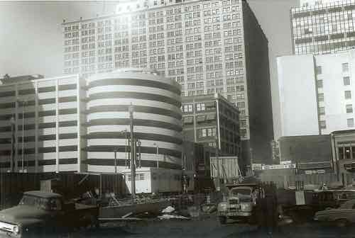
One of the two Kiener Plaza garages are visible from the exit ramp of the Macy’s garage, above.
In this historic image, we see the Macy’s garage in the background as the Kiener garages are built in the foreground.
It is hard to sustain a vibrant downtown with so much real estate used for car storage. We built garages to accommodate everyone coming downtown but in the process created a downtown less attractive to visitors.
I just hope nobody gets the idea to list one on the National Register of Historic Places. Wait, the city likes to raze historic buildings so perhaps we should get all of them on the register. That may be the only way to reduce their numbers.
For less than 20 years 33 towers stood on 57 acres on the city’s near-north side (map). Pruitt-Igoe was a failure of massive proportions. The reasons are numerous and complex. The towers were razed over a two-year period starting in 1972. Since then the site remained (mostly) vacant.
I continually hear people make the false claim the site has remained vacant because of the old foundations that were left in place. To debunk this often repeated myth I turned to the person that would know best: Martin Braeske.
Braeske, a planner formerly with St. Louis County, was working in the planning office for the St. Louis Public Schools in February 1994 when they broke ground on the Gateway Middle School for Science and Technology to be built on a portion of the former Pruitt-Igoe site. Braeske, now retired, is an Adjunct Professor at Saint Louis University. So I emailed my one-time instructor and asked him his thoughts on the foundations preventing site development:
Each tower had a partial basement for boiler and mechanical systems equipment. The ones we found were intact and simple filled in with dirt. We dug them out, punched holes in the bottom to equalize the water table and demolished the walls to about eight feet below the finished ground level. While this did cost a bit, it is not a major deterrent to redevelopment of the site.
The old foundations are not a big deal. If anything has prevented development of the Pruitt-Igoe site it has been the city’s fragmented politics over the decades. Late December 1992:
The federal judge overseeing the area’s school desegregation program is giving the St. Louis Housing Authority two weeks to hand over part of the old Pruitt-Igoe tract as the site for a $30 million magnet school.
U.S. District Judge George F. Gunn Jr. noted in his order that the federal court last year had approved the Pruitt-Igoe location as the site for the Gateway School.
In May, the St. Louis School Board filed an application with the Housing Authority to acquire 18 acres at Pruitt-Igoe, a public housing complex demolished in the 1970s.
The authority owns the property and the U.S. Department of Housing and Urban Development has a lien on the tract.
The Tenant Affairs Board, which represents public housing tenants, opposed the deal. It contended that under federal law it has the “first right of refusal” in land transactions that affect public housing tenants.
Gunn disagreed, at least regarding the Gateway case. In an order late Wednesday, he said the tenants’ board cannot block the Pruitt-Igoe deal. He pointed out that the site is a “vacant debris-strewn area” that has had no residents for more than 15 years.
He ordered the Housing Authority to disregard the tenant board’s intent to develop the site the School Board wants for Gateway School.
(Source: St. Louis Post-Dispatch 12/25/1992)
The remaining 39 acres are still vacant 15 years after the school opened, becoming an urban forest. Interest in Pruitt-Igoe remains as strong as ever. Local filmmakers are hard at work on a documentary on the project. See their site at Pruitt-Igoe.com (under construction) or follow them on Twitter @PruittIgoe.
Pruitt-Igoe is known around the world. I recently received this email:
My name is Phil Bosch. I’m an artist based in Holland who is coming this Oktober and November to St. Louis to work on a special video documentary project. I would like to investigate the memories of former residents of the now defunct Pruitt-Igoe housing complex. For the citizens of St. Louis this place is still an open space in the city, like an inverted monument of a history that seems to be forgotten.
Slowly this housing complex seems to have taken on a mythological status.  My film will be a study on its mythological status on the one side and the realm of experiences of the former residents on the other. The goal of my project is to enter, imaginatively, this huge building complex, even though its physical appearance is no longer there to be seen. While the Pruitt-Igoe no longer exists physically, it still exists in the memory of the former residents. It appears that despite the negative aura of the complex (the death of Modernism, the site’s history of crime and vandalism), there is still a coherent social group in the area who meet regularly. Thus, my goal would be to search for memories of a place where many lives were connected by this architecture that no longer exists.
I would like to document these memories. First of all, I would like to video the site of Pruitt-Igoe, which now has been taken back by nature. Next, I would like to contact people who had lived there or who otherwise have memories of the buildings.
Main streets across this country, from big cities to suburbs to small towns, have been abused by urban planners over the second half of the 20th Century trying to find the right formula to reverse the exit to the edge.
In big cities you had white flight and schools as explanations for flight but in many small towns these reasons didn’t exist. They didn’t have the mall on the edge of town drawing customers away from main street. They had only the single school district. However, many had Wal-Mart pulling customers out of the existing downtown’s.
The “solutions” were almost universal from big city CBD‘s to suburban areas to small towns. With some exceptions these all failed:
One-way traffic – charming main streets were turned into high speed roads to get through town. See Collinsville IL and many others.
Elimination of on-street parking – Saw this in Springfield MO. A street where you could drive through but you couldn’t stop and shop.
Pedestrian mall – a few have done well but most separated remaining customers from remaining stores.
Indoor mall – an alternative to the open-air pedestrian mall is the enclosed indoor mall.
Removal of projecting signs – main streets were cleansed of unique signs. Projections were viewed as a bad thing.
Uniform signage – uniformity was considered an asset. All businesses were encouraged to have the same font & size.
Concrete canopies – numerous towns were sold the idea of uniform concrete canopies over the sidewalks. Beautiful facades were bisected.
Modernize facades – cheap modern materials covered detailed old storefronts. Sometimes the original facade can be restored but often they are damaged beyond repair.
Structures over roadway – Salina KS has 4-5 open grid structures over their main street. Adds nothing but a dated look.
Parking in rear – Many towns built excessive parking behind main street buildings. With new rear entrances the street out front became useless.
Visuals of some of the above, all coincidentally from Kansas towns:
Atchison KSCoffeyville KSSalina KS
Agree? Disagree? Have additional “solutions” to add to the list? If so, use the comments below.
AARP Livibility Index
The Livability Index scores neighborhoods and communities across the U.S. for the services and amenities that impact your life the most
Built St. Louis
historic architecture of St. Louis, Missouri – mourning the losses, celebrating the survivors.
Geo St. Louis
a guide to geospatial data about the City of St. Louis