Home » Transportation » Recent Articles:

The 2013 Northside-Southside Study Was About Development, Not Transit

In 2006/07 I attended many public meetings on a proposed Northside-Southside light rail line, it was finalized in 2008. In writing about these plans in the last year, people have asked if I’d seen the new study that was done, it’s not the same as it was in 2008. The study they’re referring to, Transit Oriented Development Study for the PROPOSED NORTHSIDE-SOUTHSIDE ALIGNMENT, isn’t anything new on the actual transportation side. It was completed in July 2013. At first, it wasn’t online. I pushed to get it online…downloading it on April 18 2014.

Today’s post is about this study — dispelling myths about what it is — and isn’t.  My criticism of running high-speed light rail down streets like Natural Bridge & Cherokee is the street grid will be severed to achieve desired speeds.  I’m an advocate of rail transit, and the preferred route. If it were up to me, I’d build it immediately — as modern streetcar/tram instead of light rail. This greatly simplifies construction by eliminating the need to reduce conflicts with a train speeding down the center of the street.

STUDY OBJECTIVE: To assist the City of St. Louis, its neighborhoods, and developers with preparing for and taking advantage of transit investment along the proposed Northside-Southside Alignment.

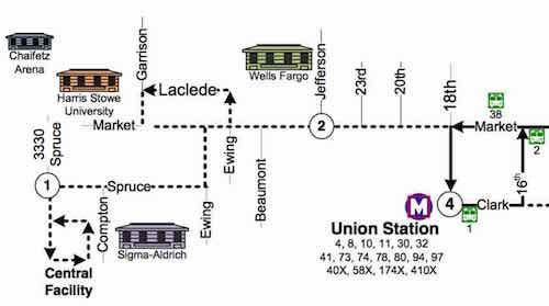
As the study title & objective indicate — it is about development related to proposed stations.  The study is a detailed look at two stations on the proposed alignment: Kingshighway & Cherokee.

This study builds upon the goals set forth in previous plans, while giving a strong framework for decision-making regarding Transit Oriented Development, which ,as defined by HUD, is compact, mixed-use development in close proximity to transit facilities. Transit Oriented Development promotes sustainable communities by providing people of all ages and incomes with improved access to transportation and housing choices and reduced transportation costs that reduce the negative impacts of automobile travel on the environment and the economy. This report aspires to meet these goals and study the Alignment at this higher level of detail, with a comprehensive analysis of each of the proposed stations, a set of Station Area Plans that describe detailed development programs, building form and distribution, street improvements, and environmental analysis for the proposed Cherokee and Kingshighway Stations. These two stations were selected because they embody a similar range of challenges and opportunities to the other station areas along the Alignment. In future studies of the other station areas, lessons from Kingshighway and Cherokee can be readily applied.

The study makes no mention of what happens between stations.

Two East-West streets are between Cherokee & Arsenal-- Utah & Wyoming
Two East-West streets are between Cherokee & Arsenal– Utah & Wyoming

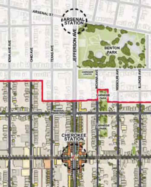
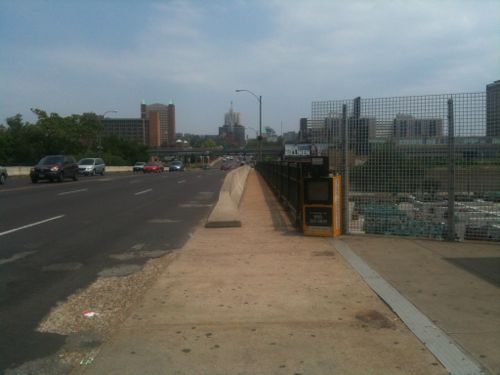
Depending upon how the Arsenal & Cherokee stations would be designed — both Wyoming & Utah could be cut off — no more crossing at either. Most likely the Northbound platforms would be located north of Arsenal & Cherokee, respectively. The Southbound platforms would be located South of each. This, rather than a shared platform, requires the least amount of width.

Looking East across Jefferson at Wyoming, May 2013. Benton Park on left, Cherokee Recreation Center on right

The distance between the two proposed stations is 4/10ths of a mile. Another 4/10ths North would be a Gravois station. The streets of Crittenden, Pestalozi, & Lynch would become no-crossing points. Another 4/10ths of a mile North to a station/crossing at Russell, with no-crossing allowed in between.

We should build North-South rail connection, but not at the expense of the street grid and the access it currently affords. Build modern streetcar on the Northside-Southside route. Keep the grid fully intact.

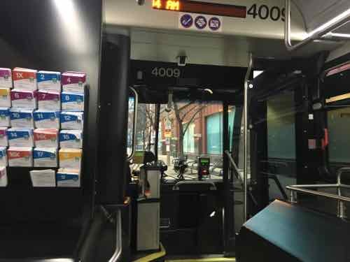
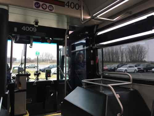
The study showed the current Siemens high-floor light rail vehicles in the new proposed street-runing lines. Not going to happen. In-street platforms and high-floor vehicles don’t work together.

The Siemens SD-400 & SD-460 vehicles are a 1980s design, used in only three regions worldwide: Pittsburgh, St. Louis, and Valencia, Venezuela. Shown: Shrewsbury opening August 2006
Upcoming modern streetcar lines in Cincinatti & Kansas City use the same 100% low-floor vehicles. (CAF's Urbos 3/100)
Upcoming modern streetcar lines in Cincinatti & Kansas City use the same 100% low-floor vehicles. (CAF’s Urbos 3/100)

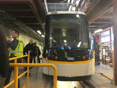
The best solution to simplify platforms and make ADA-compliance easier is 21st Century 100% low-floor vehicles.

From Wikipedia — a list of cities with Urbos 70 and Urbos 100 vehicles:

  1. Cuiabá, Brazil (40 ordered)
  2. Salvador, Brazil
  3. Belgrade, Serbia (30)
  4. Seville, Spain
  5. Granada, Spain
  6. Cádiz, Spain
  7. Debrecen, Hungary (18)
  8. Edinburgh, Scotland (27)
  9. Málaga, Spain
  10. Besançon, France (19)
  11. Nantes, France (8)
  12. Zaragoza, Spain (21)
  13. West Midlands, England (£40 million order for 20, with options for five)
  14. Kaohsiung, Taiwan (9 ordered; ACR system built in; no need for catenary)
  15. Cincinnati, Ohio, USA ($25 million for 5 trams)
  16. Sydney, Australia. ($20m order for 6 trams; order subsequently expanded to 12 trams)
  17. Freiburg im Breisgau, Germany (12 ordered)
  18. Kansas City, Missouri, USA
  19. Budapest, Hungary (47; €90m order for the 47 trams)
  20. Utrecht, Netherlands (27 ordered; to be operational in 2018)

See videos of the Urbos in Belgrade (Serbia)Kansas City, and Cincinatti.

The beauty of modern streetcar vehicles is they can be used for light rail as well. So if the lines were to continue into North & South St. Louis County the same vehicles could travel at higher speeds on closed right-of-way.

When it comes to the actual transit design of Northside-Southside, the final 2008 study still remains. The 2013 was a look at development options — a good thing considering how we’ve failed to capitalize on existing light rail stations since the first line opened in 1993.

— Steve Patterson


St. Charles County & St. Louis County Connected Via Public Transit

Five days a week people take public transit to/from St. Louis & St. Charles counties! No, MetroLink light rail wasn’t secretly extended over the Missouri River. No, MetroBus doesn’t serve St. Charles County either. “How”, you ask?

Just the way Madison County Transit enters the City of St. Louis, St. Charles Area Transit (aka SCAT), enters St. Louis County. In late February I took the last morning SCAT bus from the North Hanley Transit Center into St. Charles. Over four hours later, I took the first SCAT bus back.

The shuttle type bus used by SCAT.
The shuttle type bus used by SCAT at North Hanley. They can’t/don’t get close to the sidewalk for easy boarding via wheelchair. No curb ramp exists on the end so I had to backtrack to find the nearest ramp. .
I'm now at the nearest ramp to reach the white bus. Metro needs to add a curb ramp and/or SCAT needs to pull closer to the sidewalk.
I’m now at the nearest ramp to reach the white bus. Metro needs to add a curb ramp and/or SCAT needs to pull closer to the sidewalk.
The I-70 Commuter bus makes six stops in St. Charles plus one at North Hanley
I got off on the last stop -- the Streets of St. Charles, the driver is putting the wheelchair lift away. I'll post about that development on Thursday. Click image to see my initial post on it from February.
I got off on the last stop — the Streets of St. Charles, the driver is putting the wheelchair lift away. I’ll post about that development on Thursday. Click image to see my initial post on it from February.

We departed North Hanley on time — here’s the official schedule for the last SCAT bus leaving St. Louis County:

  • 8:55am North Hanley
  • 9:19am St. Joseph Health Center/Main St St. Charles
  • 9:24am Ameristar Casino
  • 9:31am Cave Springs Commuter Lot
  • 9:38am Zumbehl Commuter Lot
  • 9:46am Fairgrounds Commuter Lot
  • 9:50am Streets of St. Charles — where I got off
  • 10:16am last morning drop off at North Hanley

The route, logically, is designed to serve St. Charles residents needing to get into St. Louis County for the day. Just 30 minutes to go from the Fairgrounds Commuter Lot to North Hanley four times each weekday morning, starting at 5:44am!  Still, my bus from North Hanley into St. Charles had about 10 other passengers — people I presume were going to work.

In the afternoon the SCAT I-70 bus runs four times, starting at North Hanley at 1:38pm, the last on 5:59pm.

  • 1:38pm North Hanley
  • 1:45pm Fairgrounds Commuter Lot
  • 1:52pm Zumbehl Commuter Lot
  • 2pm Cave Springs Commuter Lot
  • 2:11pm St. Joseph Health Center/Main St St. Charles
  • 2:16pm Ameristar Casino
  • 2:20pm Streets of St. Charles — where I got on
  • 2:42pm arrival at North Hanley — next departure is 2:48pm

I’m so glad to see the City of St. Charles operating transit buses, connecting to the rest of the region — via St. Louis County. However, the webpage and route maps need improvement. Online maps for the four St. Charles routes must be viewed separately. No system map exists, at least not online.  Still, it’s a start.

— Steve Patterson


1960s Grand Bridge Closed For Replacement 5 Years Ago Today

It was five years ago today when St. Louis closed the 1960s Grand Ave bridge over the railroad tracks so it could be replaced:

The Grand Bridge is scheduled to close from Chouteau Avenue to the I-64 off-ramp on Monday, March 14, 2011. The bridge will close before the morning rush around 5:00 am. The bridge will be closed to traffic for about 14 months; the entire project is expected to be completed in 18-24 months. During that time, the current bridge will be completely removed and replaced. When finished, the project will provide a dramatic facelift to Midtown. (St. Louis)

The old bridge had 3 vehicles lanes in each direction and vary narrow sidewalks.

Looking north from the old transit stop, June 2010

The new bridge, with 2 lanes per direction & wider sidewalks, opened in July 2012. See: New Grand Viaduct Huge Improvement, Development Opportunities Remain.

The Grand bridge over I-44 will soon be replaced, though traffic won’t be completely cut off:

The driving surface of the bridge will be completely replaced and the bridge will be raised to meet interstate standards. Although the project will be completed in stages, drivers can expect fewer lanes across the bridge and will not be able to make left turns during construction, MoDOT said.

At least one lane will be open in each direction on Grand during each stage of construction.

Construction is expected to start in June, with all driving lanes expected to be open by the end of the year. (Post-Dispatch)

Work continues on a new kingshighway bridge over the railroad tracks South of I-44, the old bridge closed last July.

— Steve Patterson


Trump Is Less Than A Half Mile Away Today, Last Week I Took Public Transit 20+ Miles To Hear Bernie Sanders

Before this year, and despite being an active voter for 30+ years, I’d never seen a presidential candidate in person. At noon today Republican frontrunner Donald Trump will be speaking at the Peabody Opera House — less than half a mile away from my downtown loft. I won’t go hear him speak — not worth minimal effort.

A week ago, however, I traveled 20+ miles to hear Sen. Bernie Sanders at SIUE’s Vadalabene Center. As I indicated on February 2nd, I already voted for Bernie Sanders via absentee ballot. Today’s post is mostly about my journey there and back via public transit.

You’re probably thinking it took forever, the answer is no & yes.  Getting there was as fast as driving, coming back took three times as long.

Each weekday morning the Madison County Transit 16X Edwardsville-Glen Carbon Express makes two pickups from St. Louis, it makes nine drop offs. At 7:02am I caught the first 16x at 6th & Washington Ave.  Thirty-six minutes later I was on the SIUE campus.

Driving from my loft would’ve required my husband to use our Enterprise CarShare membership so I could use our car, it would’ve taken 36-41 minutes for me to drive there. With the time it would’ve taken me to walk from parking to the line using my wheelchair on public transit saved me time — and money.

At 7:04am I was on the 16x on WB Washington Ave between Broadway & 6th. There were 5-6 people on the bus -- they boarded at Jefferson & Pine
At 7:04am I was on the 16x on WB Washington Ave between Broadway & 6th. There were 5-6 people on the bus — they boarded at Jefferson & Pine
At 7:20am we made our first stop, at a Park & Ride lot next to the Gateway Center in Collinsville IL
At 7:28am we stopped at a park & ride lot in Glen Carbon IL. The next stop was Beck Hall at SIUE

Upon arrival at the campus I didn’t stop to photograph — I wanted to get to get in lime at the Vadalabene Center. As I was making my way to the back of the line a volunteer stopped me and said I could follow her to the disabled entrance.

At 7:48am I was almost inside, myself and others who are disabled were able to bypass the long line. Had I driven the walk from the parking lot to the door would've been exhausting.
At 7:48am I was almost inside, myself and others who are disabled were able to bypass the long line. Had I driven the walk from the parking lot to the door would’ve been exhausting.
I was inside just before 8am. Mr. Sanders began speaking around 10:30am. I could not have been any closer to the stage!
I was so close I was the first person to shake his hand after he came off the stage, I took this image just after -- 11:29am
I was so close I was the first person to shake his hand after he came off the stage, I took this image just after — 11:29am
15 minutes later I was leaving the Vadalabene Center, heading for Beck Hall

I already knew the next express bus to St. Louis wasn’t for another 4 hours — I’d need to take two buses and a train to get home.

A few Madison County Transit buses came by before the next bus I needed,

I had two options:

  1. #19 to Collinsville > #18 to Emerson Park > MetroLink to St. Louis
  2. #4 to Granite City > #5 to Emerson Park > MetroLink to St. Louis

Both were within minutes of each other — just shy of two hours total. Based upon when I arrived, the #2 option via Granite City would be next. While waiting I began talking to someone else who attended the event, we talked much of the way until I got off the train downtown. Turns out he’s married to a woman I’ve known for at least a decade, they live in Webster Groves!

It was worth all the trouble to hear & meet Bernie Sanders!  Missouri & Illinois both hold primaries on Tuesday, along with Ohio, Florida, and North Carolina — please vote.

— Steve Patterson


Downtown Trolley Route Expands To Compton Starting March 14th

Tuesday’s post (Metro Makes Long-Needed Changes at 18th & Clark, Still Violates ADA) listed the many MetroBus route changes effective March 14th, one of which was the #99 Downtown Trolley. As mentioned in a July 2014 post, the Trolley will reach Union Station — and well-beyiond, as it turns out.

First, some history…

Me leaving the #99 Downtown Trolley after the first ride on July 6, 2010. This replaced the #99 Downtown Circulator that used non-wrapped buses. Photo by Jim Merkel, Suburban Journals
In 2014 new low-floor buses replaced the ones used since 2010
The trolley route hasn't changed except the addition of one stop on Spruce at 14th.
The trolley route hasn’t changed except the addition of one stop on Spruce at 14th.

The route — until March 14th — had a loop at each end: City Museum and Civic Center MetroBus Center. Mostly in Downtown, a little in Downtown West (West of Tucker).

Overview of new route, click image to view PDF
New West extension, only daytime on weekdays

As you can see, it’ll now turn around at 18th & Clark, with some turn arounds still at Civic Center. The main difference is going much farther West on Market Street into Midtown. This will connect more businesses with the Central Business District (CBD). It’ll also show how bad this area is for pedestrians trying to use public transit — see Harris-Stowe State University Campus Disconnected From Adjacent City.

I personally would like to see the trolley not do the 14th/Delmar/16th loop around City Museum — but continue on Washington Ave to 18th or 20th — to reach Market. This would better serve Downtown West, a stronger connection with the CBD.  Rather than them turning around on each end half would go clockwise, half counter-clockwise.

Looking forward to riding the new route, checking out the new stops.

— Steve Patterson

b

b

b

b

b

b

b


Advertisement


[custom-facebook-feed]

Archives

Categories

Advertisement


Subscribe