The 2013 Northside-Southside Study Was About Development, Not Transit
In 2006/07 I attended many public meetings on a proposed Northside-Southside light rail line, it was finalized in 2008. In writing about these plans in the last year, people have asked if I’d seen the new study that was done, it’s not the same as it was in 2008. The study they’re referring to, Transit Oriented Development Study for the PROPOSED NORTHSIDE-SOUTHSIDE ALIGNMENT, isn’t anything new on the actual transportation side. It was completed in July 2013. At first, it wasn’t online. I pushed to get it online…downloading it on April 18 2014.
Today’s post is about this study — dispelling myths about what it is — and isn’t. My criticism of running high-speed light rail down streets like Natural Bridge & Cherokee is the street grid will be severed to achieve desired speeds. I’m an advocate of rail transit, and the preferred route. If it were up to me, I’d build it immediately — as modern streetcar/tram instead of light rail. This greatly simplifies construction by eliminating the need to reduce conflicts with a train speeding down the center of the street.
STUDY OBJECTIVE: To assist the City of St. Louis, its neighborhoods, and developers with preparing for and taking advantage of transit investment along the proposed Northside-Southside Alignment.
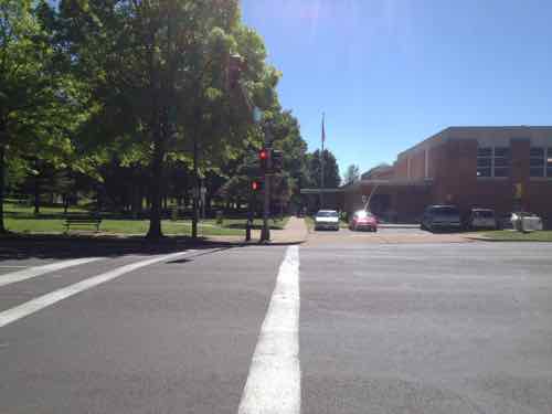
As the study title & objective indicate — it is about development related to proposed stations. The study is a detailed look at two stations on the proposed alignment: Kingshighway & Cherokee.
This study builds upon the goals set forth in previous plans, while giving a strong framework for decision-making regarding Transit Oriented Development, which ,as defined by HUD, is compact, mixed-use development in close proximity to transit facilities. Transit Oriented Development promotes sustainable communities by providing people of all ages and incomes with improved access to transportation and housing choices and reduced transportation costs that reduce the negative impacts of automobile travel on the environment and the economy. This report aspires to meet these goals and study the Alignment at this higher level of detail, with a comprehensive analysis of each of the proposed stations, a set of Station Area Plans that describe detailed development programs, building form and distribution, street improvements, and environmental analysis for the proposed Cherokee and Kingshighway Stations. These two stations were selected because they embody a similar range of challenges and opportunities to the other station areas along the Alignment. In future studies of the other station areas, lessons from Kingshighway and Cherokee can be readily applied.
The study makes no mention of what happens between stations.
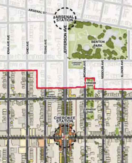
Depending upon how the Arsenal & Cherokee stations would be designed — both Wyoming & Utah could be cut off — no more crossing at either. Most likely the Northbound platforms would be located north of Arsenal & Cherokee, respectively. The Southbound platforms would be located South of each. This, rather than a shared platform, requires the least amount of width.
The distance between the two proposed stations is 4/10ths of a mile. Another 4/10ths North would be a Gravois station. The streets of Crittenden, Pestalozi, & Lynch would become no-crossing points. Another 4/10ths of a mile North to a station/crossing at Russell, with no-crossing allowed in between.
We should build North-South rail connection, but not at the expense of the street grid and the access it currently affords. Build modern streetcar on the Northside-Southside route. Keep the grid fully intact.
The study showed the current Siemens high-floor light rail vehicles in the new proposed street-runing lines. Not going to happen. In-street platforms and high-floor vehicles don’t work together.
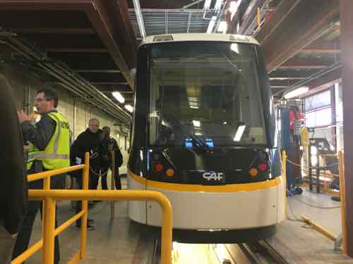
The best solution to simplify platforms and make ADA-compliance easier is 21st Century 100% low-floor vehicles.
From Wikipedia — a list of cities with Urbos 70 and Urbos 100 vehicles:
- Cuiabá, Brazil (40 ordered)
- Salvador, Brazil
- Belgrade, Serbia (30)
- Seville, Spain
- Granada, Spain
- Cádiz, Spain
- Debrecen, Hungary (18)
- Edinburgh, Scotland (27)
- Málaga, Spain
- Besançon, France (19)
- Nantes, France (8)
- Zaragoza, Spain (21)
- West Midlands, England (£40 million order for 20, with options for five)
- Kaohsiung, Taiwan (9 ordered; ACR system built in; no need for catenary)
- Cincinnati, Ohio, USA ($25 million for 5 trams)
- Sydney, Australia. ($20m order for 6 trams; order subsequently expanded to 12 trams)
- Freiburg im Breisgau, Germany (12 ordered)
- Kansas City, Missouri, USA
- Budapest, Hungary (47; €90m order for the 47 trams)
- Utrecht, Netherlands (27 ordered; to be operational in 2018)
See videos of the Urbos in Belgrade (Serbia), Kansas City, and Cincinatti.
The beauty of modern streetcar vehicles is they can be used for light rail as well. So if the lines were to continue into North & South St. Louis County the same vehicles could travel at higher speeds on closed right-of-way.
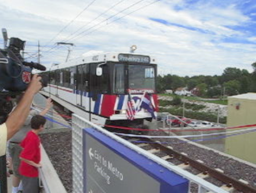
When it comes to the actual transit design of Northside-Southside, the final 2008 study still remains. The 2013 was a look at development options — a good thing considering how we’ve failed to capitalize on existing light rail stations since the first line opened in 1993.
— Steve Patterson
given funding realities, we’ll be dead before this has a chance to happen, so why worry?
Good idea!,can’t possibly let the do nothing crowd take over, oh wait, they already run the place.
Since the Siemens SD-100 and SD-160 (which are closely related to the SD-400 and SD-460) have been discontinued, your concerns about Bi-State acquiring more vehicles of the same design may be a non-issue: https://en.wikipedia.org/wiki/Siemens_SD-100_and_SD-160
The operating environment and the operating speeds are closely related. If you have a secure, dedicated, right-of-way, you can operate at higher speeds, with streetcars, light rail vehicles, buses or pedicabs. If you’re operating in general traffic, you can’t go faster than anyone else, again, in a streetcar, light rail vehicle, bus or pedicab.
And the real question is do you want to offer “local” service or “express” service, or both? Do you want to move people short distances, long distances, or both? Do you want to provide frequent service with smaller vehicles (and more operators) or do you want to provide less frequent service with larger / longer vehicles (and fewer operators)? Do you want fewer, bigger “stations” or do you want more, smaller “stops”? They’re all potential answers, and they directly inform which vehicle would be the best choice – “modern streetcar” may or may not be, depending on te goals the community chooses.
I realize the 80s designs are discontinued. though they got more built in 2005. I want others to realize any new rail line not directly connected to the existing will use different vehicles — not the same ones we have that are shown in the 2013 study.
The questions in your last paragraph are all valid — the public needs to be discussing these.
The original Metrolink was also built on existing railroad right of way, no? That made it much easier as a lot of the overpasses were in place. A route down Jefferson should definitely be a tram.
. . . or just more-frequent bus service, with or without “better” stations or stops . . .
Articulating buses work well too, or even double-deckers!
That looks likes a good urban streetcar. Technically the urbos cars, as you point out, fit into a urban, people scale environment pretty well. To me a key sentence is where you say “The study makes no mention of what happens between stations.”
That is the exact problem. How does this study function as part of a whole? It is impossible, or difficult to judge without a greater understanding of how a transit system should operate.
Take Gravois for instance, if you are looking for vacant, development ready land, it is full of auto lots and suburban style eateries.
Should Gravois have a streetcar line? How does this interact with buses and other lines?
I have yet to see regional authorities, who is it East West Gateway? offer ideas about what a finished streetcar line might look like and how it interacts with the rest of transit. Along with an overlays showing pedestrians, bicycles with the always present automobile, how does this all work as a unit?
The McKee proposal is a huge misstep, how does transit impact that area? The basic nature of transit is that it serves the whole city, the region. So how can there not be a comprehensive idea of the goals that are being pursued? especially when tax dollars are at stake. It is irresponsible government. Is there a shape to the transit system?
I think streetcars can be very effective in a well done transit system.
St Louis, however, is not well done.
Maybe its just me, but I think we should be looking at this as part of a larger proposed system, at least a concept of how the system should work, whether or not anything gets built immediately.
Somehow building piecemeal lines here and there can’t be the right approach. It is going to be a hard sell without showing how this line will improve the city and transit.
As Mark-AL suggests double decker buses might be a good substitute for streetcars, creating a similar identity. In fact you could probably replicate a complete streetcar system with double decker buses and play with it until it seems right.
Here’s a good article on development and developers: https://www.minnpost.com/politics-policy/2016/04/what-most-neighborhood-activists-dont-understand-about-real-estate-developme
Interesting article, but it misses asking what policies are in place before the project is even considered.
From a developer perspective, there is going to be a stronger interest if the developer has a sense of how the surrounding buildings and communities impact a project. For example, would a developer be interested in a location in a district that was pedestrian orientated, with at least some density, and inclusion of good transit and bicycle connections and be attracted accordingly by the certainty of purpose?
In contrast the McKee Plan illustrates uncertainty. Is the area going to be autocentric or pedestrian oriented? It’s not clear, nothing is clear, hence the difficulty in attracting investment.
Ultimately the policies that will shape the Northside should have already been debated and be in place by now.
I think developers would flourish under a city leadership that had a better understanding of cities. For St. Louis it is less about blocking views than creating a coherent environment that has meaning and pizzaz.
Most developers have only ONE interest, to make money! They don’t give a damn about autocentric or transit or bicycle connections or historic or suburban or urban, all they care about is do the numbers work out and are there (enough) buyers for what I’m selling (demographics)? Yes, having a plan gives them a framework to look at, but the bigger the project, the more flexible any framework becomes, especially if an area is interested or desperate for something new. The ONLY time a framework is rigid is when the community is fat and happy and does NOT want any change, then the “rulles” will be used to create hurdle after hurdle to stymie a developer.
That’s like saying a restaurant is only in business to make money, the quality doesn’t matter.
If there were no building codes developers would cut corners and build shoddy and unsafe buildings to “make money”
Lets take Soulard, a developer cannot build a strip mall in the middle of Soulard to “make money”. And in fact the rigorous historic legislation has increased property values and encouraged development. A developer in Soulard knows that another developer cannot build a strip mall adjacent to his property to “make money” and thereby devalue the investment that was already made.
Unfortunately most of the region already operates with the anything goes mindset you advocate. The prime human value is for the developer to use a “make money” style of urban planning. At least this gives you many choices of garbage environments to live in.
I could cite cities like San Francisco or Portland as examples of well designed cities that prosper with good design, or say the City of London and its Unitary Plan (called something else now) and how it creates a structure that serves both developers and the public.
But I don’t think you are are interested in knowledge or solutions, rather you seem more concerned about clinging to your ideological viewpoint.
The irony is St Louis has being doing it your way for decades and with it has come with decades of decline and economic stagnation throughout the region.
What is really funny the process (or lack of it) you advocate is costing your developers who want to “make money” a good deal of money.