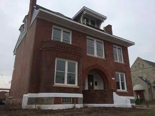
I like to end each week with a positive post and nothing is more positive than a favorite building, long written off, getting rehabbed. A large house on Delmar, with unique dormers, has been in disrepair for years. A few months ago a friend posted on Facebook that work was starting on the building. Earlier this month I took the #97 MetroBus to photograph the progress.
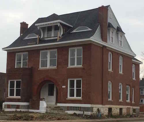
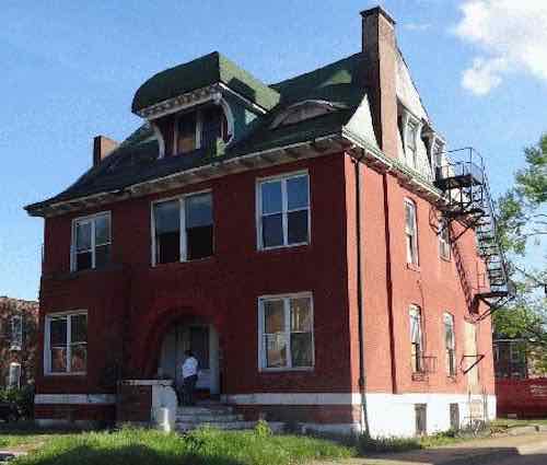
Work was still ongoing on my December 12th visit.Diagonally across Delmar & Pendleton, click image for mapThis March 2014 photo from GEO St. Louis shows the old fire escape from when the house was divided into multiple units.
City records indicate 4270 Delmar Blvd was built in 1893 and contains 5,687 sq ft. This property is just a couple of blocks West of another favorite building, that also recently got rehabbed, now known as Freedom Place. Fingers crossed someone will take on the building at the East end of Fountain Park.
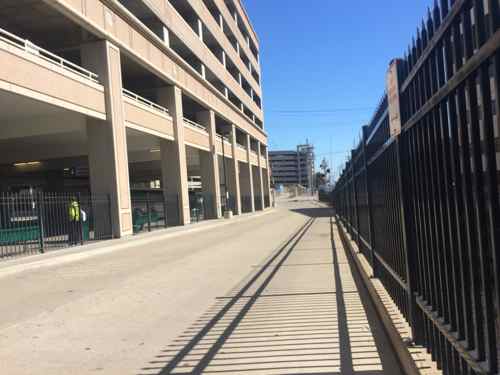
Our busiest MetroLink light rail station is the Central West End (CWE) station, but it’s also one of the worst when it comes to connecting to a public street. If you head up the stairs/elevator at the west end of the platform you’ll get to a plaza where Euclid Ave used to be, now part of the Washington University Medical School/BJC campus that’s decimated the street grid. Head east and the grid remains mostly intact, but getting to it isn’t easy.
Looking east toward Taylor from the CWE MetroLink platformLooking east down the service driveway toward Taylor
The connection is narrow & winding, designed to get MetroBus rides to/from light rail. It isn’t designed for pedestrians to reach Taylor Ave. Why might someone want to go to Taylor Ave? For one, various hospital related buildings are within a few blocks. The CWE is to the north, but one can use the former Euclid Ave to connect with Euclid Ave. To the south, however, is the Forest Park Southeast (FPSE neighborhood) and The Grove, accessed via Taylor Ave.
Expensive investments in mass transit infrastructure, such as light rail, needs to be designed to maximize use and thus, return on investment. If you didn’t see the train occasionally or the crossing gates, you’d never know a station as been just off Taylor Ave for more than two decades.
I February 2010 I posted I would live at 4005 Delmar, then a vacant & boarded building, I was dreaming of it being renovated.
Boarded storefronts at sidewalk level, February 2010
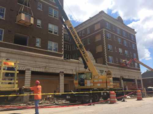
The building at 4005-4011 Delmar has since attracted the attention of a developer, who also dreams:
We believe being a dreamer is every bit as important as being a do’er. In our personal and our professional lives, the members of The Vecino Group are dedicated to imagining a better world and then working to make it happen.
I too agree it is important to dream, I’ve shared mine here for over 9 years.
Last year:
A housing developer from Springfield, Mo., has embarked on a $12.7 million project to renovate the building as 68 affordable apartments for homeless vets. The five-story building, at 4011 Delmar Boulevard, is in the city’s Vandeventer neighborhood, about three blocks from the John Cochran VA Medical Center.
Plans call for the building, named Freedom Place by the developer, to be redone as 20 studio apartments, 24 one-bedroom units, 16 two-bedroom units and eight three-bedroom units. Monthly rents are scheduled to range from $369 to $640. (stltoday)
According to city records, the building had 100 one-bedroom apartments and three “other” units. Hopefully the new mix of units will work well.
I pass by this project on the #97 MetroBus, but recently I was in the area photographing for my post on the North Sarah Apartments so I got a closer look at the progress.
New windows greatly improve the appearance
I’m curious to see how the ground-level will be used. Will a neighborhood coffeehouse be able to open? A small local market perhaps? The area desperately needs economic activity to create jobs for the veterans that will live here, as well as others.
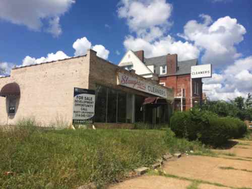
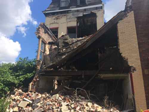
Directly across the street a 1945 commercial building is vacant. With its side parking lot this could be a good market for the area.At 4035 a commercial storefront addition in from of a 19th century house has collapsed.
Housing for these vets is huge, but we must also finds ways to rebuild the local economic base to create jobs. One local effort is Bridge Bread:
Bridge Bread is a social entrepreneurship initiative designed to provide job opportunities for guests of The Bridge. The goal of the initiative is to help disadvantaged guests engage in a financially rewarding effort that enhances self-worth, promotes dignity and enables the guests to help themselves.
It takes much more than a shelter cot to rebuild the lives of the homeless. Kudos to the people behind The Vecino Group!
The August day my college friend Mary Ann and I drove into St. Louis is permanently etched in my memory like it was last year, but it was 23+ years ago! The plan: be roommates in Washington DC. We were young and ready to conquer the world. Unemployment was also high and after seeing her mom’s townhouse in Benton Park, touring St. Louis with her and her friends the next day, I decided St. Louis would be my new home — there was just so much untapped potential.
I thought I was part of a first wave of 20-somethings to discover the urban core but as I met people 10-20 years older they quickly reminded me when they were my age places I thought were cool like the Central West End (CWE), Lafayette Square, and Soulard were the unrealized potential they saw the 1970s/80s.
Let’s start much earlier with young folks who moved to a booming city:
Henry Shaw (1800-1889) came to St. Louis two months before his 19th birthday had a huge impact on the development of his new city.
Adolphus Busch (1839-1913) moved to St. Louis at age 18. At 21 he married the daughter of candle maker and brewery investor Eberhard Anheuser. Anheuser was 37 when he moved to St. Louis.
Joseph Pulitzer (1847-1911) came to St. Louis by boxcar at around age 20, completely broke. By age 32 he bought bought two newspapers which he combined to form the St. Louis Post-Dispatch.
Scott Joplin (1867/68-1917) grew up in Texas but moved to Sedalia after attending the Chicago World’s Fair (1893) and in his early 30s moved to St. Louis. Around age 40 Joplin moved on to NYC to further his musical career.
Luther Ely Smith (1873-1951) moved to St. Louis at age 21 to attend Washington University’s School of Law. Later Smith was the driving force behind the effort to rebuild our riverfront. In his early 40s Smith recruited a 20-something to come to St. Louis to be the first full-time municipal city planner in the nation.
Harland Bartholomew (1889-1989), St. Louis’ first planner (roughly from 1915-1950), sought to reorder the older areas through large-scale demolition, he was 25-26 when he arrived in St. Louis from the east coast.
And some who moved to, stayed in, or returned to a now-aging city:
Stan Musial (1920-2013) was just 17 years old when he came to St. Louis from his home state of Pennsylvania to play baseball. Except during WWII Musial called St. Louis home the rest of his life. He was 42 when he retired from playing baseball. He had money and fame but stayed. Musial was a VP of the Cardinals when the team moved from North Grand to a new stadium downtown in 1966.
Gyo Obata (1923-) was born in San Francisco but moved to St. Louis around age 18-19 to attend Washington University, and to avoid being internment during WWII. Obata got his masters at Cranbrook, served a year in the Army and worked for SOM in Chicago for 4 years, returning to St. Louis at age 28. At 32 he joined “he joined architects George Hellmuth and George Kassabaum in establishing the St. Louis-based architecture firm Hellmuth, Obata and Kassabaum.”
Jack C. Taylor (1923-) returned to St. Louis after serving in World War II. At 25 he started working at Lindberg Cadillac, located within the city, and by 34 started Executive Leasing with seven cars. Later the name was changed to Enterprise, after the USS Enterprise.
Tina Turner (1939-) moved to St. Louis at 16, where she and husband Ike were discovered.
A quiet bohemian area of the 1950s became Gaslight Square after a 1959 tornado brought new attention:
By summer 1960, it was the place to be for beats, preppies, well-dressed adults, street troubadours and tourists. Olive pulsed with a happy cacophony wafting from places called the Crystal Palace, Left Bank, Laughing Buddha, and Dark Side. Jack Carl dished pastrami and genial abuse at 2 Cents Plain. A row of columns outside Smokey Joe’s Grecian Terrace anchored the landscape.
On March 24, 1961, the St. Louis Board of Aldermen anointed the obvious by renaming two blocks of Olive as Gaslight Square. Laclede Gas Co. later installed 121 gas streetlights, adding flicker to the buzz.
By summer 1961, Gaslight was noisier with more restaurants, taverns, nightclubs and shops. Some of the antiques dealers were squeezed out by rising rents. “The old gang doesn’t come around anymore, but perhaps it is a necessary evil of growing,” Massucci said as cash registers jingled.
Big and future names in show biz played the square. An 18-year-old singer named Barbra Streisand was warm-up for the Smothers Brothers. Allen Ginsberg recited poetry to mellow jazz. Miles Davis and Singleton Palmer were regulars. Earnest ministers opened the Exit, a coffee shop promising meaningful discussion and “jazz liturgy.” (A Look Back • Gaslight Square in St. Louis burned brightly but briefly in the 1960s)
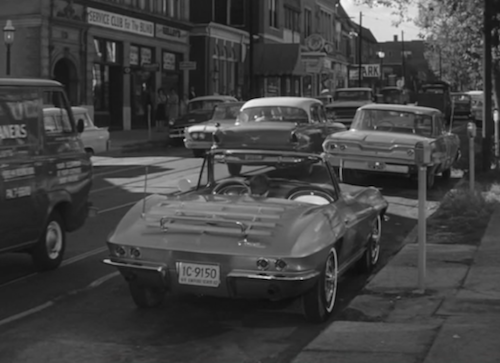
The popular show Route 66
The familiar Corvette from the Route 66 television series parked on Olive in Gaslight Square, Click image for IMDB page on this episode
The two handsome young stars are walking in Gaslight Square at night:
Tod: “Buz if you still don’t like it here we can always move into the country and get a little closer to the quarry.”
Buz: I didn’t say that, I said living in Gaslight Square was like living inside a drum, I haven’t had a good nights sleep since we got here. It’s not that I don’t like it, it’s I just don’t know how long I can last.”
They were working at the Rock Hill Quarry.
After I first moved to St. Louis the neighbor across the street from my parents in Oklahoma told me about visiting Gaslight Square in the 60s — he would’ve been in his 20s or 30s at the time. By 1972 O’Connells Pub was the last business to leave Gaslight Square.
That same year a 42-year old Herbie Balaban opened Cafe Balaban on Euclid Ave. Duff’s opened as well in 1972. Left Bank Books had already been open 3 years. Rothschild Antiques also opened in 1969. If you were a 20/30-something Euclid Ave was the in place to be.
I have numerous friends who saw a future is the area around Lafayette Park, rehabbing run down mansions that had been chopped up into rooming houses. Others began renovating buildings in the Soulard neighborhood, designed as an urban renewal clearance area just 25+ years earlier.
Plate Number 16 is a plan for the reconstruction of the Soulard Neighborhood. Some of the more important features of the plan are: the extension of Gravois Avenue from Twelfth Street to the proposed Third Street Interstate Highway, providing a direct route to the central business district; the widening of 18th Street, the widening and extension of 14th Street, the widening of Park and Lafayette Avenues; underground garages in the multi-storied apartment area between 12th and 14th; a neighborhood part of 10 acres or more complete with spray pool, community facilities and game courts; the extension of Lafayette Park to serve this as well as other neighborhoods; landscaped areas throughout the community for passive recreation; enlargement of the City Hospital area; grouping of commercial areas into orderly shopping centers and the complete reconstruction of the neighborhood into super residential blocks with a new street pattern to serve these blocks and to discourage through traffic. (1947 Comprehensive Plan)
In the late 1970s a group of idealistic 20/30-somethings moved to the declining Murphy-Blair neighborhood, buying buildings to rehab. Never heard of Murphy-Blair? That’s because they changed the name to Old North St. Louis. Some from that original group remain.
There are many more examples but hopefully you get the drift. We’ve had no trouble attracting the 20/30-sometyhing crowd over the years. Our problem has been one of retention. On that topic I’ve had friends, fellow Gen Xers, move out to the suburbs once they had kids, but I know one family that returned to the city and another to Clayton, both within 5 years of leaving. Neighbors in my loft building moved to the suburbs with their young daughter but they kept the loft for when they move back. Other neighbors are Baby Boomers visited by their grandkids.
Yes, millennials are moving to the core — just like every generation prior. But…but…the numbers, it’s bigger now! Well, sorta:
THE MILLENNIALS — sometimes called Generation Y, and defined by many demographers as ranging from ages 18 to 37 — make up the largest population cohort the U.S. has ever seen. Eighty-six million strong, it is 7% larger than the baby-boom generation, which came of age in the 1970s and ’80s. And the Millennial population could keep growing to 88.5 million people by 2020, owing to immigration, says demographer Peter Francese, an analyst at the MetLife Mature Market Institute.
This echo-boom generation totals 27% of the U.S. population, less than the 35% the boomers represented at their peak in 1980. When the baby-boom generation drove the economy in the 1990s, growth in gross domestic product averaged 3.4% a year. As the Millennials hit their stride, they could help lift GDP growth to 3% or more, at least a percentage point higher than current levels.
The Millennials already account for an annual $1.3 trillion of consumer spending, or 21% of the total, says Christine Barton, a partner at the Boston Consulting Group, which defines this cohort as ages 18 to 34. As the economy pulls out of an extended period of sluggish growth, helped in part by this rising generation, annual growth in consumer spending is likely to revert to its long-term average of 3.5% to 4% from about 2% now. Likewise, consumer spending on durable goods could rise sharply. (Barron’s)
It’s not that Millennials are moving to the city in greater percentages, there’s just so many of them. Because of the efforts of prior generations, they get to build upon and expand the opportunities for the next generations. It’s a cycle I don’t see stopping. When kids born today are 20 they’ll do the same.
In a few week I’ll turn 47 and I’ll have spent half my life in St. Louis, I’m very glad I stuck around. Now I get to see all the exciting things the Millennials are doing. I’ll enjoy them with my finance, a member of the Millennial generation.
The previous St. Louis Treasurer, Larry Williams, conducted limited testing of modern parking collection technology on South Grand in 2006. There were a couple of blocks of pay-per-space and a few pay-n-display. (FYI: In St. Louis the treasurer is responsible for parking revenue.)
What’s the difference between the two types?
With pay-per-space each fixed-length parking space is assigned a number. After parking you walk to a nearby pay station, enter the space number where you parked, and pay.
With pay-n-display you park, walk to a nearby pay station, buy time, return to your vehicle and display the receipt on the inside of the windshield.
Each has pros & cons compared to each other and against individual meters. In 2006 it was concluded neither pay-per-space or pay-n-display were right for St. Louis. I say the design of the test was flawed — only 2-3 blocks of each and they were next to each other. Someone might park in front of a store and use pay-per-space and a few days later park a block away and use pay-n-display.
A pay-per-space station on South Grand, November 10, 2006A pay-n-display station on South Grand, November 10 2006
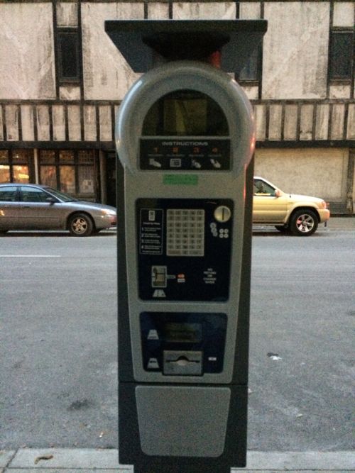
Monday St. Louis Treasurer Tishaura Jones will announce new pilot programs testing new parking technology. The treasurer’s office director of communications, Deborah Johnson, told me via email:
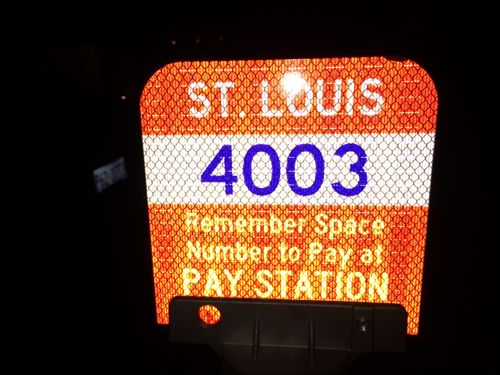
The city has previously tested “pay-n-display” units, where the customer must walk to the unit, print a ticket, and walk back to their car to display the ticket. The multi-space units this pilot is testing will use the “pay by space” method, where the customer types in the 4 digit space number they are parked in and does not have to return to their vehicle to place a ticket. Instead, the system automatically monitors and communicates with enforcement officers.
I reminded her both pay-per-space & pay-n-display were tested simultaneously.
In response to another question she said:
The pilots are in four locations in the city: 10th Street between Chestnut and Washington; Broadway and Pine; Euclid and Laclede; and Euclid and Maryland. The pilot will be in place for six months.
The new equipment is already installed on 10th Street, I posted the following picture to Twitter & Facebook yesterday:
Pay-per-space stations on 10th will be functional starting Monday
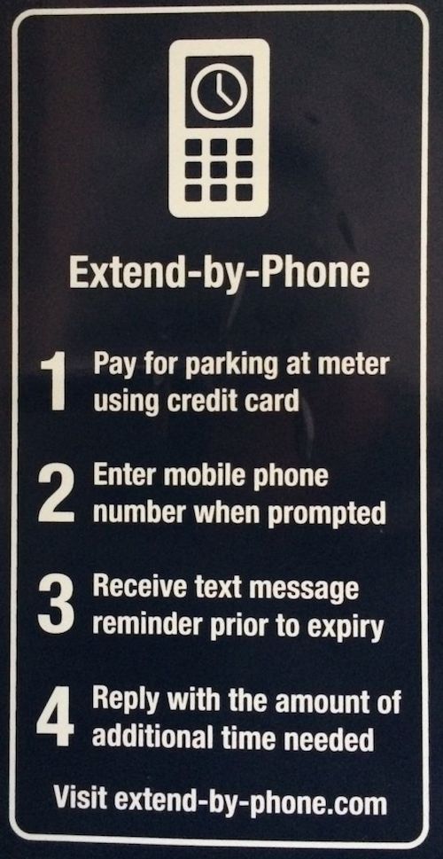
Of note is the stations on 10th accept coins, bills, and credit cards. You’ll even be able to extend the amount of time via phone!
Instructions to extend time, click image to view the mobile-optimized website.
From the site:
Extend-by-Phone is an innovative service that enables the parking meter to send you a text message reminder when your parking is about to expire, and allows you to add time to your parking by simply replying to the reminder message with the amount of additional minutes you need.
Small signs with numbers replaced the meters on 10th
I’m glad to see recent testing isn’t limited to a very tiny test area as in 2006. I also appreciate the caution given the infrastructure costs to change, but I’d hoped for something more modern years ago. Treasurer Jones has only been in office a little over a year and for someone who campaigned on not wanting to be a “parking czar” she and her staff are making changes at a record pace compared to her predecessor.
I look foreword to hearing the official details on Monday.
AARP Livibility Index
The Livability Index scores neighborhoods and communities across the U.S. for the services and amenities that impact your life the most
Built St. Louis
historic architecture of St. Louis, Missouri – mourning the losses, celebrating the survivors.
Geo St. Louis
a guide to geospatial data about the City of St. Louis