August 25, 2017Accessibility, Featured, ParksComments Off on Wheelchair Users Locked Out Of St. Louis Public Park
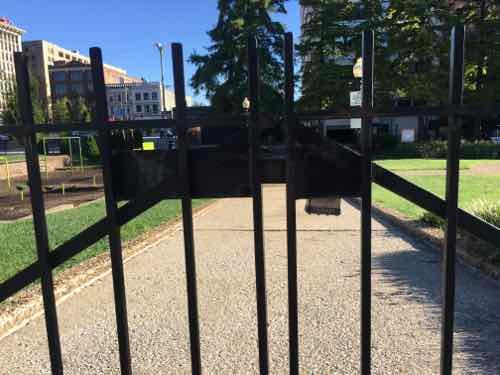
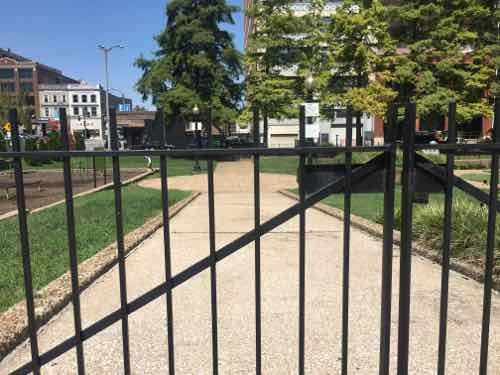
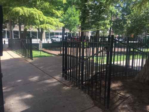
Since moving downtown nearly a decade ago I’ve spent a lot of time in Lucas Park, just two blocks to the East. Unfortunately, the city has me locked out of the park. Lucas Park has four entrances — two along the South edge off Locust St, and two along the North edge off St. Charles Sr. The city’s parks department keeps the two South gates locked and opens the North gates during the day. The problem is the two North gates both have steps.
When I first began visiting Lucas Park only one ramp existed — the South entrance nearest to 14th. When the dog park was added a 2nd ramp was installed near the North entrance nearest to 13th. That pedestrian gate gas unlocked by the nearby gate at the ramp does not. It’s impossible for me, while using my power wheelchair, to use Lucas Park.
The SW gate is locked on Wednesday August 23rd @ 8:32am.The NE gate for the ramp was also lockedAn hour later, on the way home from the grocery store, the park still looks inviting.
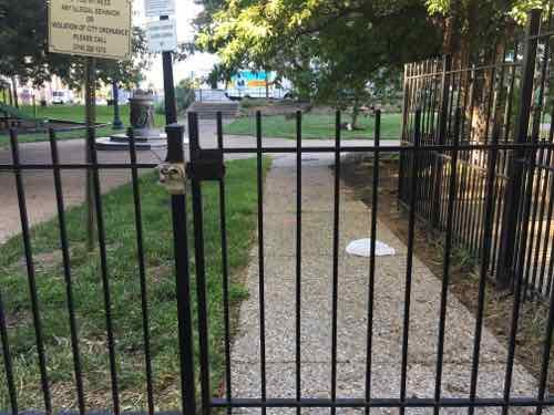
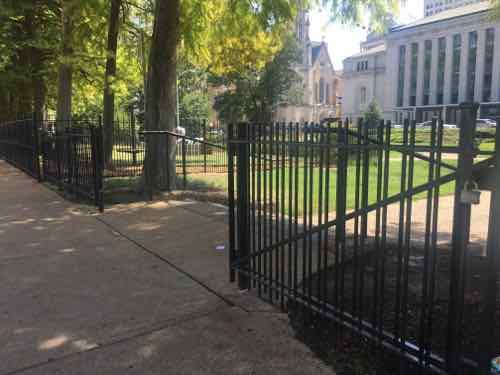
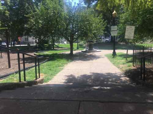
Wednesday I emailed the first two photos to a couple of city officials and posted them to social media. Yesterday was also a very nice day, I tried to visit the park again on my way to the grocery store.
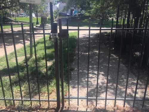
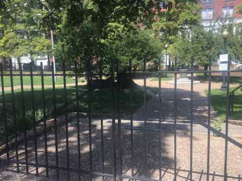
A couple of people were working out in the park at 1:50pmAgain, the SW gate to the original ramp was lockedThe NW gate was unlockedIt has steps downThe NE gate to the newer ramp was lockedThe NE gate with steps was wide openI can see into the park, I just can’t get insideThe SE gate was locked.
As I understand it, city parks dept employees come out to unlock the NE & NW gates, but don’t unlock the NE gate for the ramp. I don’t think this is deliberate, just another example of people not thinking.
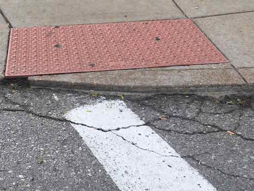
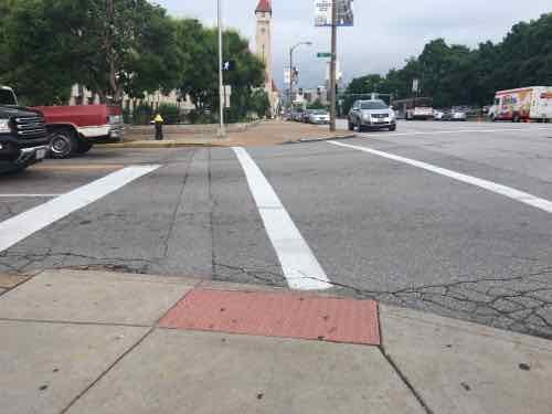
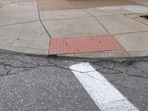
Over a year ago I posted about one of the many poorly design/constructed curb ramps in this city, see Shoddy Curb Ramp/Crosswalk At 16th Street & Market St from May 2016. Here are a couple of images from that post:
May 2016: The pained crosswalk was to left of the line, but most pf the ramp was to the right. Plus, the ramp violated the “no lips” rule. One corner of the tactile surface hangs over the curb!May 2016; Looking West across 16th St at Market, note the location of the crosswalk relative to the detectable warning mat.
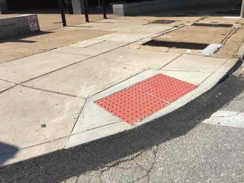
At some point in the last year I was told the city will be correcting this ramp. I’ve been through this intersection a lot over the last few months and hadn’t noticed a change — until the other day. While I was glad to see the city hadn’t forgotten about it, I was disappointed by what was done.
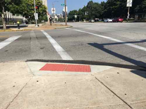
The old ramp was torn out and a new one poured. New asphalt fills in the gap that was removed to form the new ramp.Another view. Like most ramps, this one is still too high so the asphalt helps make up for the error. Not ADA-compliant.Looking West. Hopefully the crosswalk will be changed at some point, but the ramp still directs you into the intersection.
So the city has gone from an “F” to a “C-“. How much did this cost? What does it take for the city to do A or B work?
I know, I should just accept this city doesn’t care about pedestrian like it does motorists, crappy pedestrian infrastructure has been the norm for too long.
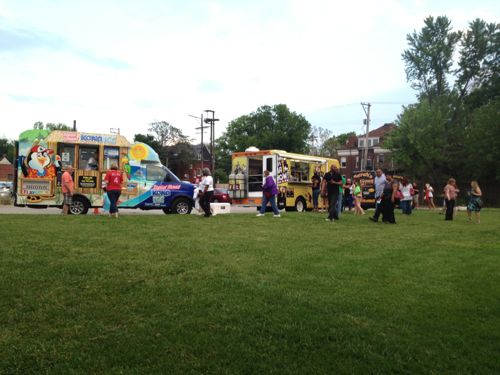
More than two decades after the Americans with Disabilities Act was signed, the ongoing food truck revolution remains largely inaccessible to those of us who use wheelchairs. Not because of the tricks themselves, but because of where they park.
From a 2013 post — Foods trucks at Third Degree’s open house require lining up on grass — a challenge for some.
In early September a proposed food truck park was in the news:
St. Louis may soon get its first food truck park — a regular gathering spot for some of the area’s best-regarded mobile kitchens. The proposed site is on a stretch of South Vandeventer Avenue — not far from the popular Grove entertainment district — that officials hope to regenerate with new businesses.
Some planning remains, and the park’s developers have yet to choose the project’s name. But they have a site and hope to conduct a food truck pop-up event there this fall.
If plans work out, next spring a rotating assemblage of food trucks will begin to operate daily on what is now an overgrown lot next to the long-ago home of Liberty Bell Oil Co. The vacant building at 1430 South Vandeventer will be redone as the joint commissary for the food trucks. (Post-Dispatch)
My hope is if this moves forward it’ll be designed so everyone can patronize the food trucks. Often I can’t reach the trucks parked downtown at one of my favorite spots: Citygarden.
Even downtown many access problems exist. Just walk up right?No, in this case the window isn’t lined up with the walk shown in the previous picture.Market next to Citygarden is a very narrow strip of concrete. Enough to stand on but not enough for a wheelchair.Even when the window is lined up it can still be a challenge if there are others in line.
When I started blogging 12+ years ago I argued for more food carts to activate streets — food trucks weren’t a thing yet. I still wish food carts were more common because they trend to be easier to access in a wheelchair. But trucks have replaced carts so now we need to ensure the public can access them.
Part of the implied contract when taking a bus to a destination is when you’re dropped off at your stop, you’ll be able to get to the corresponding stop in the opposite direction for the return trip. Seems simple enough, right? But in many parts of the St. Louis region being able to reach a bus stop in the opposite direction is impossible if you’re disabled. I don’t go looking for them, I run across them just going about my life.
Since the Americans with Disabilities Act of 1990 became law, transit operators, like Metro St. Louis, formerly Bi-State Development Agency, have equipped their fleet of buses with either a lift or ramp in new low-floor models. This permits those us who use wheelchairs to board every bus with access to hundreds of routes throughout the region — theoretically, at least. Bus routes are operated on municipal/county roads throughout our region. The responsibility for these public rights-of-way (PROW) are that of the municipality, county, or state — depending upon the entity that has assumed responsibility. Regardless, the transit agency generally isn’t responsible for the pedestrian infrastructure (sidewalks, curb cuts. etc) to/from their bus stops.
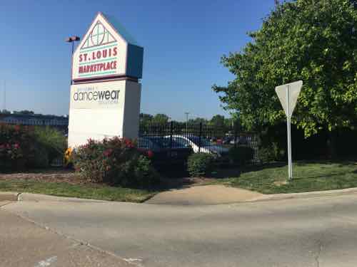
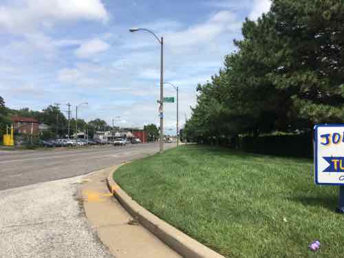
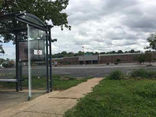
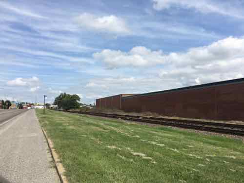
Today’s example involves a 2.5 mile stretch of Manchester Ave from McCausland Ave to Kingshighway Blvd — all in the City of St. Louis. A third of this stretch is fronted by the St. Louis Marketplace — a strip retail center that opened in 1992 — it was St. Louis’ very first TIF project. A former industrial area was reclaimed for retail by relocating railroad tracks further away from Manchester. The entire site was new from scratch and post-ADA. Furthermore, Manchester Ave has had a bus route for the entire 26 years I’ve lived in St. Louis — probably for at least 3-4 decades. For years it was the #59, but after the Cross County MetroLink line opened in 2006 the #59 stops at Maplewood and the #32 was extended West to Maplewood.
The morning of August 11th my husband forgot his phone, so I decided to take it to him. His morning client lives a few blocks North of Manchester Ave. in the Franz Park neighborhood (aka Dogtown), 24th ward. With my car key I was able to leave his phone in the door pocket and a note on the seat. I needed to return to Manchester Ave and catch the #32 Eastbound.
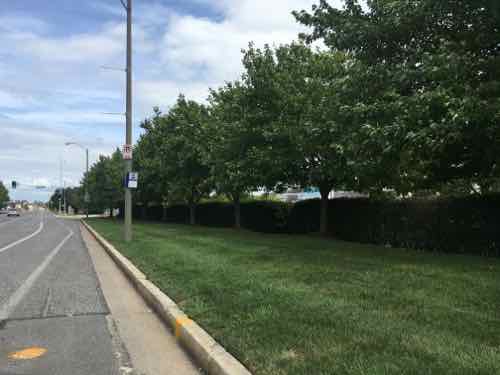
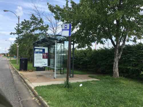
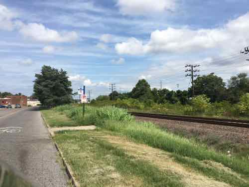
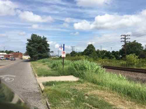
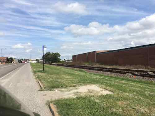
I crossed Manchester at the light at Prather Ave, Google maps told me the stop was to the right. Thankfully ramps were built.Looking West toward the bus stopThankfully my chair had enough power to roll over the grass. If it had been wet or muddy I couldn’t have reached this bus stop . A user of a manual chair probably couldn’t have. and finally, why should ab;e-bodied pedestrians have to walk through grass? The bus stop sign is attached to the light post.
When I boarded the bus from this stop the driver asked me how I managed to get to the stop! On the bus I noticed a stop further East that I’ve blogged about before.
A bench head been casually placed at the stop, partially blocking the pad that was barely big enough for a wheelchair user to turn around.
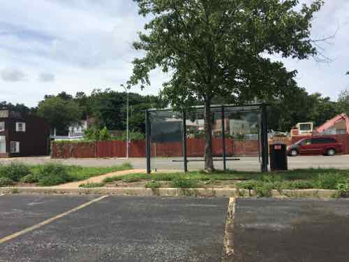
I paid attention to all the stops as we passed each one. I decided I needed to look at the entire stretch, not just one stop here or there. Again, the distance between Kingshighway and McCausland is 2.5 miles. There are 12 MetroBus stops in each direction. All 12 in the Westbound direction are accessible — not ideal but adequate. However, in the Eastbound direction only half are accessible/adequate.
Six aren’t accessible, although I was able to power through the grass to reach one of them. Four of these six inaccessible bus stops are in front of the St. Louis Marketplace, the retail development that was created 100% from scratch after the ADA became law. Let’s take a look.
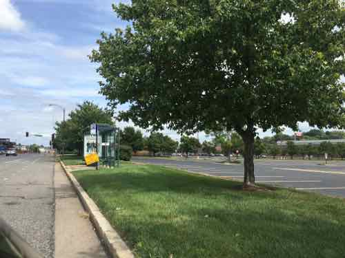
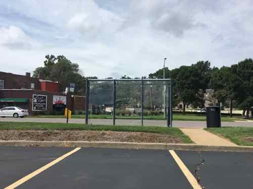
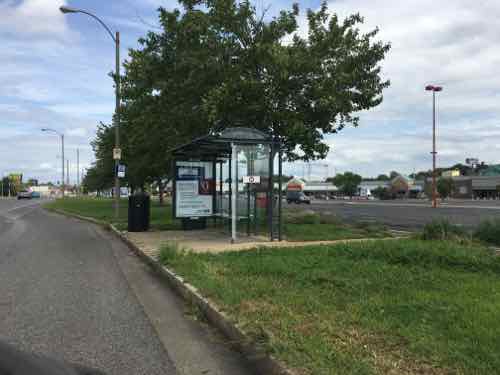
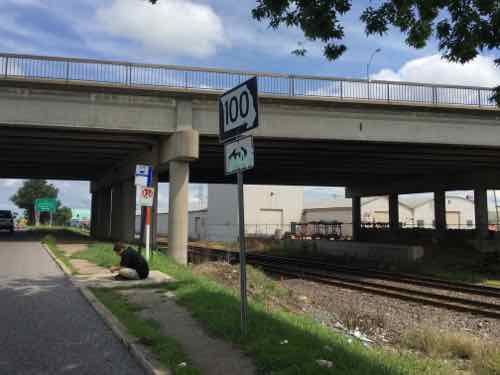
Starting at Ecoff Ave on the West edge of St. Louis Marketplace, you can see the curb ramp in the lower right corner but it leads to grass not sidewalkMy guess is either the city or developer were supposed to add a sidewalkThis is the stop I used on August 11thThe next EB stop has a place for the bus to pull over and a shelter — the city & Metro planned ahead for this stopThe back side shows a curb prevents access from the parking lotThe next stop also has a space for the bus and a shelter, but no sidewalk along ManchesterThis looks accessible. right?Like the previous stop, a curb prevents access from the parking lotThe last of the four stops in front of the shopping center also has a shelter. Here you can see concrete was recently added — the old walkway next to the shelter was too narrow to meet the ADA minimum.Oh yes, it’s wide enough now, But no sidewalk leading to the bus shelter and shrubs are at the backCharter vans blocked my view of the walkway but it’s safe to assume it has a curb like the two previous stops.The next stop East of the shopping center isn’t accessible at allBut yes, Metro added a wheelchair pad in a recent round of ADA improvements. I guess we’re expected to cross Manchester between signals to reach this stop? If I’m heading EB would a driver let me off at this stop? Anyone using this stop risks getting hit crossing Manchester.The bench that was blocking the stop at Hampton was moved after I tweeted about it, but seating is needed — just not blocking the pad.And the 6th inaccessible stop is just East of MacklindMetro also poured a pad here even though there’s no safe way to reach it.
Previous posts on a couple of bus stops on this stretch of Manchester:
Today post is another example of poor quality work. This isn’t about being a cash-strapped city — this is incompetence at all levels.
Looking West across 16th St at Market, note the location of the crosswalk relative to the detectable warning mat, click image for map to intersectionFrom the crosswalk looking toward the “ramp”Here’s a closer view of the ramp.
Looking at Google Street View I know this was done by the city sometime between September 2009 and August 2015. It was during this time the city took possession of the building from the federal government. I remember the old ramp, there are still some like it. It was done during a period when detectable warnings weren’t required, plus the location had no relationship with their crosswalk. But it was flush with the street.
The maximum vertical hight change allowable per ADA guidelines is 1/4″ — but this curb ramp is substantially higher than that. Sadly, it is very common to have greater than 1/4″ at ramps. Many are so bad I email the Streets Dept’s asphalt guy directly so they can do a non-compliant patch. Many things can be non-compliant, but still useful. This, and others, are hard to use and they damage the drive wheel on my chair. This would be very challenging for someone using a manual chair, and a trip hazard for a person walking with a cane or walker. In fact — this is a trip hazard for anyone walking here.
I have no idea if this was built by city employees or by a hired contractor. Either way, we’s never tolerate such shoddy work on our homes or cars — it shouldn’t be allowed in the public right-of-way.
AARP Livibility Index
The Livability Index scores neighborhoods and communities across the U.S. for the services and amenities that impact your life the most
Built St. Louis
historic architecture of St. Louis, Missouri – mourning the losses, celebrating the survivors.
Geo St. Louis
a guide to geospatial data about the City of St. Louis