July 11, 2018Featured, Public TransitComments Off on Readers Split On Northside Light Rail Alignment
In the recent non-scientiifc Sunday Poll readers were split on the twi competing alignments that’ll be recommended to East Wes. Planning approved a decade ago was to use 14th, North Florissant, and Natural Bridge. Since then a big chunk of the St. Louis Place neighborhood was razed for the new West headquarters of the National Geospatial Agency (NGA West), now under construction. So an alternative is to use Cars & Jefferson avenues to serve NGA West’s workforce.
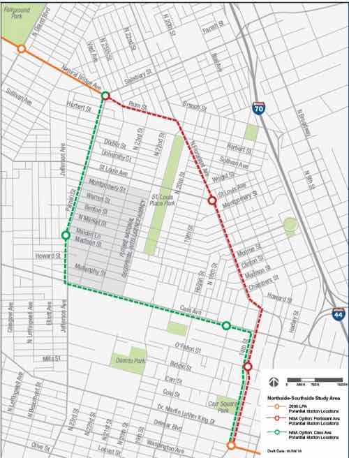
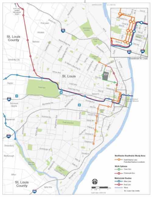
The red represents North Florissant alignment, green the Cars/Jefferson alignment
Here are the results:
Q: Which of the two alternatives for the Northside light rail alignment do you prefer:
Unsure/no answer 9 [36%]
Florissant Ave 9 [36%]
Cass Ave 7 [28%]
The results are lower than typical weeks, and some selected Unsure/no answer because they oppose investing in additional rail transit — even though taxpayers approved taxes to build additional rail to serve North & South St. Louis.
Advantages of Florissant Ave alignment:
Serves 3 neighborhoods: Carr Square, St. Louis Place, & Old North St. Louis
Taking transit to/from Crown Candy would be easier than now
No 90-degree turns to slow down speeds
Advantages of Cars Ave alignment
Serves 2 neighborhoods: Carr Square & St. Louis Place
Serves more of Jeff Vanderlou neighborhood than Florissant Ave alignment
Serves NGA West
Could spur development of long-vacant Pruitt-Igoe site
It’s tough picking a favorite. Would more NGA workers use transit if it stopped right out front? Would think significantly reduce auto traffic to/from NGA?
On Monday I’ll propose an alternative to the Case Ave alignment.
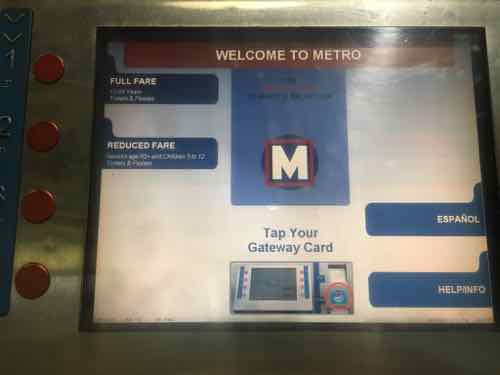
July 9, 2018Featured, Public TransitComments Off on First To Test Metro’s Reduced Fare Gateway Card
In February 2014, on a trip to Chicago, I used my first contactless transit card. It took a few times to get used to it but it was far easier than paying cash and deciding if I needed ro pay up front for a 2-hour transfer. If I bought a transfer, I had to keep track of it. With a contactless card there’s no problem paying the bus fare while wearing gloves. No fumbling with bills & coins. Just tap & go. My post from February 2014: Contactless Transit Smart Cards. I’d already contacted Metro St. Louis about being a reduced fare tester.
Metro was supposed to have such a system in place in St. Louis by then, but other cities, including Chicago, experienced huge problems when launching their contactless cards. Other delays happened tooo, but Metro has been cautiously slow.
From April:
Metro has been working on the smart card system for more than eight years.
It’s part of a $31 million project that also included replacing fareboxes on all 400 of Metro’s buses, replacing or modifying ticket vending machines and validators and technical upgrades.
Metro in 2011 had said the card system would be launched by 2013. Later the targeted launch date was changed to 2015. That also wasn’t met. Officials blamed the delays on the complexity of integrating disparate systems on moving buses and trains and with bus fareboxes. (Post-Dispatch)
I’ve been pretty patient as the months & years passed by. In November 2015 I applied for a reduced fare Ventra card for use in Chicago. It arrived in the mail the next month, prompt9ing me to write Reduced Fare Smart Card For Chicago, Still Waiting On St. Louis.
In late 2017 I saw Metro’s now-retired Executive Director, Ray Friem, at an event at North Hanley. He explained the many pages of problems they’ve worked through and the few that remained. One issue was different vendors for bus fareboxes and a different one for MetroLink fare gates.
Earlier this year testing was opened up from a limited number of riders to sort of a public beta test — but still only full fare. I was getting inpatient. In March Friem promised me I’d be the first reduced fare tester. He was right, 3 months later I got my card!
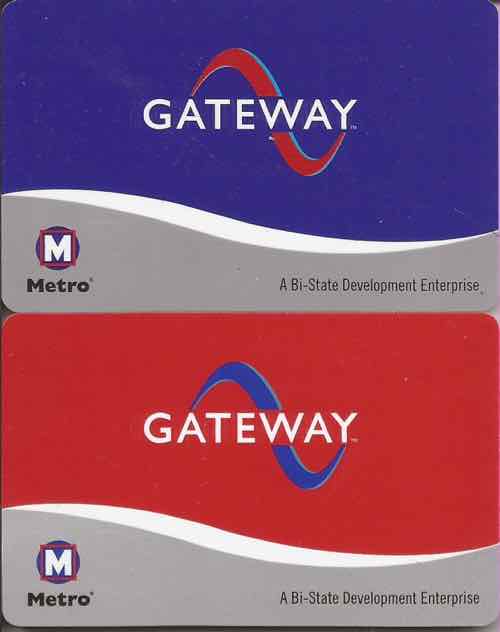
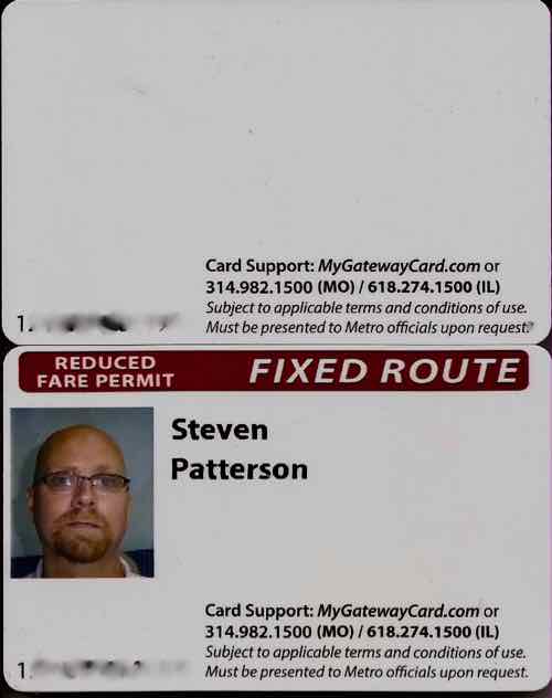
Standard fare cards are blue (top), reduced fare cards are red.The back of my husband’s full fare card includes tow card number and where to call Metro. The back of my card includes my name & photo as well as card number — only the person assigned the card can use a reduced fare card, I’ve blurred both card numbers.
I’ve now used the card 7 times — on both MetroBus and MetroLink (Light rail). My very first time using the card was on a #10 bus as I headed to an appointment with an ophthalmologist. It didn’t work. I tapped again, still didn’t work. The 3rd time it didn’t work the bus driver indicated to just wheel back to my spot so she could get going. I emailed the time, bus route, and bus numbers to the person at Metro I’d been working with for months to get this card.
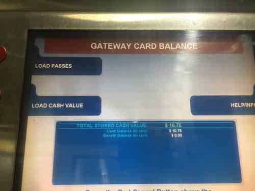
I managed to board the one bus, out of 400, that had a defective reader. Since then it has worked flawlessly, including a bus to MetroLink transfer last week! As these cards are still in testing mode, all the bells & whistles aren’t yet up & running. I can’t open an app on my phone to check transactions, balance remaining, or add funds. Can’t logon from my home computer either. I can check the by calling the number on the back of the card; I can also check the balance or add funds by visiting the Metro Store at 8th & Pine, or at a Metro ticket machine.
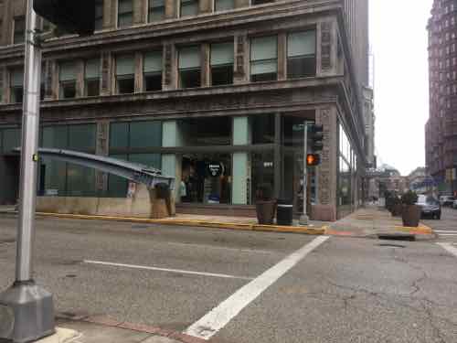
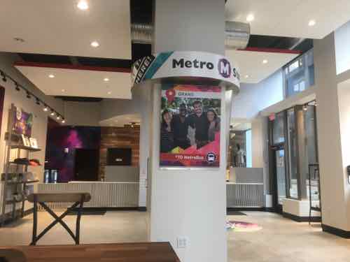
The Metro Store in the Arcade Bldg, as seen from the SW corner of 8th & PineThe machines at MetroBus centers & MetroLink stations have a reader you can tap your card to add funds, passes. or just check your balance.This day I checked my balance, $10.75 matched my spreadsheet.
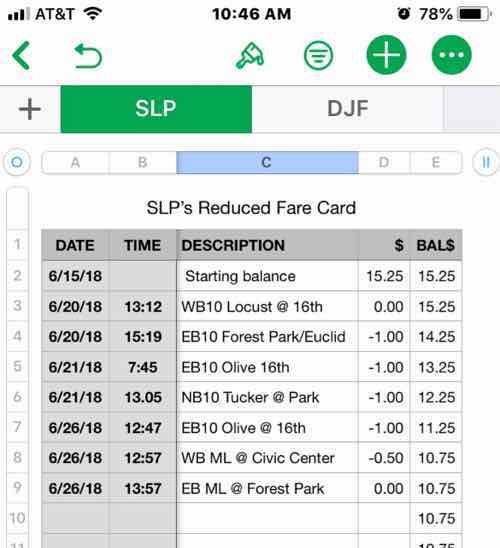
A Spreadsheet? Yes, I thought this was the best way to track my use and confirm the card is working.
Because no app is available, I created a spreadsheet on my phone using Apple’s Numbers app. This allows me to track the balance of my card.
This also helps me when I’m using Metro because the time will let me know the window in which I can use again at the transfer rate — exactly 2 hours.
The other way to check the balance is to call the number on the back of the card. At first I’d call and thought something wasn’t working. Unlike Chicago, the bus data isn’t sent in instantaneously. it’s downloaded from each bus when it returns each night. The call-in system may not know my card balance at any moment because of this, but the card itself knows. Don’t think you can exceed your balance because the bus hasn’t downloaded yet — it doesn’t work that way.
I’m told in a few months myself and others can begin testing the online portion. This will allow the autoload of passes or funds. I don’t use passes, but I love the idea of having it automatically charge a credit card I have on file whenever my balance reaches a minimum threshold.
Aside from the one faulty bus reader, everything has worked fine. I’m looking forward to helping test online functions. I’m really glad I no longer need to carry a coin purse with $1 bill & quarters! As a result of the new convenience I find myself using transit more than I would have if I still had ro use cash or 2-hour passes.
Today’sSunday Poll is a little different than most, instead of agreeing or disagreeing with a statement you’ll be asked your favorite of two alternative routes for the Northside alignment of proposed new light rail line.
After a year and a half of data analysis, study and public feedback from over 60 presentations, meetings and open houses, the Northside-Southside Study team is releasing our recommended first phase project alignment for the City of St. Louis. We knew the best route for Northside-Southside should align with community investment strategies, serve area neighborhoods and residents, and provide pedestrian access to the National Geospatial-Intelligence Agency (NGA) West campus.
Thus, the study team is recommending to the Board of East-West Gateway Council of Governments, our metropolitan planning organization, a $667 million street-running light rail investment that would run from Chippewa Boulevard in the South through downtown to Grand Boulevard in the North via one of the two North St. Louis alignment options. See map below.
The first phase would:Serve approximately47,000 people;
Carry an estimated 9,200 transit riders per day(4,200 of which are transit-dependent riders);
Access 65,000 jobs within a half-mile of the route; and
Spur possibly millions of dollars in economic development throughout our neighborhoods.
The North St. Louis Alignment From public feedback gathered during the study, we knew any Northside-Southside route should align with community investment strategies and serve area neighborhoods and residents. Additionally on the Northside, the route should provide pedestrian access to the NGA West campus.
Both the Florissant Avenue and the newly proposed Cass Avenue routes align with community investment strategies, including the Choice Neighborhoods Initiative. These options also serve the pedestrian entrances to the new NGA West campus, Carr Square and Old North neighborhoods. Although both options fulfill project needs and provide access to jobs, redevelopment and neighborhoods, the final north St. Louis route will be chosen during the next project phase, following additional technical work and community input. The map below shows the two Northside alignment options.
East-West Gateway Council of Governments Board to Receive Final Project Recommendation Later This Summer The study team will submit its final project recommendation to the East-West Gateway Board at its August 29th board meeting. The next step is to secure funding for an environmental study and project development, expected to take place during the environmental review process. At this time, a preferred alignment through North St. Louis will be chosen.
Overall, we have seen and heard great community support for this project. We know it will transform the City of St. Louis and St. Louis’ regional public transit system.
So the study team is recommending two a;ltermatoves North of downtown. Lots of pros & cons to each. The number of stations is the same for each. Either way Carr Square and what’s left of St. Louis Place neighborhood are served by either. So think about it and vote in the poll below.
This poll will close at 8pm tonight..
Wednesday I’ll share the results, what I see as the pros & cons of each, and if I’ve made up my mind — my preferred alternative.
March 19, 2018Featured, Public TransitComments Off on Nearly a Quarter of St. Louis Households Underserved by Transit
Last month Streetsblog USA had a post that caught my attention:
Where should your city aim to add transit service? The places where more buses and trains will be most useful are areas where lots of people live or work, but there’s not enough service to meet the demand.
A new data tool from the Center for Neighborhood Technology helps pinpoint these locations in cities around the U.S. The “Gap Finder” — an extension of CNT’s All Transit database — overlays demographic data and transit schedule information on maps that highlight where more people would ride transit if service levels were higher.
The transit gaps mapped by CNT are not to be confused with “transit deserts” — areas with no transit at all. Areas with some transit service may still not have nearly enough to adequately serve the people who live or work there, while areas without any service may be so spread out that fixed-route transit won’t do much good. (Streetsblog USA)
They used three cities as examples: Miami, Los Angeles, and New York City — all had lots of underserved households — their maps were covered in red.
TRANSIT GAPS On the map above, any orange and red areas show transit markets where households are underserved by transit and would benefit from improvements. Blue areas indicate where the transit market strength is already met by a minimum benchmark of adequate transit service and white areas show where the market strength for transit service is low enough that adding transit would not represent an improvement. The pie chart shows the percentage of those households underserved by transit grouped by market strength.
Note: The market is not the same as demand. The gap results from a comparison of current service to the standard or average transit service in similar neighborhoods – not the best and not the worst service, but average.
Why Are There Transit Gaps?
Transit gaps exist wherever there is a mismatch between the strength of a transit market and the quality of transit service available to the households of that community.
Calculating the Strength of Transit Markets
AllTransitTM defines the strength of a transit market by comparing a wide range of neighborhood characteristics to current transit service available in transit served areas with similar neighborhood characteristics.
I show the pie chart below, but first I want to get in closer.
Now we can see underserved areas.
Soi now what? How do we improve?
Reducing the average wait time for transit by 17 minutes for the underserved neighborhoods in St. Louis, MO would provide enough service improvement to meet minimum standards expected of the transit market in those areas.
Here’s more:
Every location and transit agency is unique, but generally one solution would be to increase the frequency of transit service along the existing (on average) 6 routes or adding new routes. Adding 7 rides per hourwould, on average, close the gap for the underserved areas in St. Louis, MO.
The measure of transit service is driven by the frequency of service, the distance to all transit stops, and the access to jobs on transit. For underserved areas in St. Louis, MO, increasing the average frequency of service from 8 to 15 total trips/hour would change the average transit service in underserved areas from 39 to 44 (out of 100).
The following summarizes headway & frequency goals:
I did not try to find flaws in their methodology. The purpose of this post us to inform others about this new tool and hopefully it’ll lead to improved service in St. Louis.
March 5, 2018Featured, Public TransitComments Off on Metro’s New Store, Still Waiting For Smart Card Fare System
For many years our transit agency, Metro, operated a retail store as part of the convention center, known as America’s Center. It was connected to the visitor’s center at 7th & Washington Ave, This location was a block West of the Convention Center MetroLink station.
I’d like to see Metro make it obvious to anyone walking, or driving, past the MetroRide store to know it is a place to buy transit passes and pick up schedules. As a fan of gift shops, I’d also like to see St. Louis transit-related merchandise: t-shirts, postcards, magnets, calendars, etc. I still have a puzzle of the Philly transit map I bought on vacation in 2001, but I have almost nothing for St. Louis. I’d love a toy MetroBus.
Step up your retail game Metro!
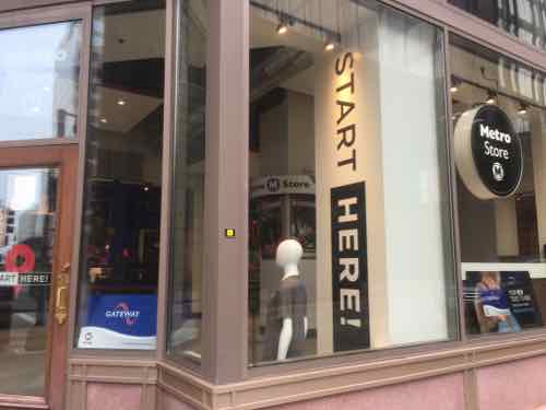
They recently moved their store to the NW corner of 8th & Pine — in the Arcade building. The space was briefly occupied by Webster University’s cafe called Gorlok Grind (March 2016 — June 2017)
View from the SW corner of 8th & Pine, with Westbound MetroLink stairs right out frontPeople walking by on the sidewalk can see in and understandLooking North insideLooking South inside
I have no knowledge of the old or new lease terms. Perhaps this new space will better serve Metro customers and attack some new riders. Though at a MetroLink station, it isn’t near any MetroBus routes. They might have done it, but they need a vending machine on Washington Ave to purchase passes/tickets — especially downtown trolley tickets.
The smart card is part of Metro’s new fare collection system, a more convenient, secure way to pay Metro transit fares. Instead of paper tickets or passes, the Gateway Card will contain a computer chip that stores Metro passes or cash value. The fare is automatically deducted when customers tap their card on fare equipment each time they ride.
“Much of our current fare collection equipment can be replaced with new technology to improve both our efficiencies as well as the customer experience.” said John Nations, Bi-State Development Agency/Metro President & CEO. “The Gateway Card and this new system will transform the way we do business and will bring our operations up to 21st century standards.”
The smart card system is currently being tested in preparation for next year’s rollout. Hundreds of Metro customers have volunteered to test the new system before it is rolled out to the general public. Metro will gradually phase in Gateway Cards to its customer groups until all customers have moved to smart cards.
Nearly four years later and we’re still waiting for the rollout. I get their caution, the rollout of these new systems in other cities have gone poorly.
Chicago’s 2013 rollout, for example:
CTA fare options that expired this week are back in place until the company that is being paid almost a half-billion dollars to manage the implementation of the new Ventra system fixes problems that have left thousands of customers frustrated, the president of the CTA said Wednesday.
The transit agency made the abrupt, if temporary, reversal in response to angry riders who this week overwhelmed a Ventra hotline in an effort to activate their new cards and in some cases have demanded their old, time-tested fare-payment choices back.
So until further notice, sales of magnetic stripe transit cards will continue at rail stations, and Chicago Card customers will be allowed to add value to their cards. But CTA President Forrest Claypool said Wednesday he is determined to stick to a Dec. 15 deadline to stop accepting the old fare cards on trains and buses. (Chicago Tribune)
We began regular trips to Chicago a year later, the Ventra card system has worked great for us.
No need to worry about having a stack of dollar bills or coins.
No need to worry about holding onto transfers.
Easily add more money to cards online or via our phones.
In Chicago it’s rare to see a person using cash to pay bus fare and boarding goes so much quicker as a result.
Last September I spoke with Metro’s Executive Director Ray Friem about these cards at a ribbon-cutting event at their North Hanley Transit Center. Friem said they’ve been working on many pages of problems getting fare systems from two different vendors to play nice with each other. Metro uses one vender for MetroBus, another at MetroLink light rail fare gates. When we spoke on September 28, 2017 he said the problems were down to just 3 pages and he expected a rollout late in the year — 2017.
My followup email from a month ago is still unanswered. You can see the draft Gateway Card website here.
AARP Livibility Index
The Livability Index scores neighborhoods and communities across the U.S. for the services and amenities that impact your life the most
Built St. Louis
historic architecture of St. Louis, Missouri – mourning the losses, celebrating the survivors.
Geo St. Louis
a guide to geospatial data about the City of St. Louis