The historic Cupples 7 warehouse was razed last year because owners let a small hole in the roof become a big hole over the years, destroying the structure. Last week an aerial image of similar roof damage at Lemp Brewery was posted on Facebook.
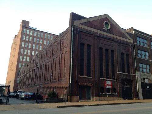
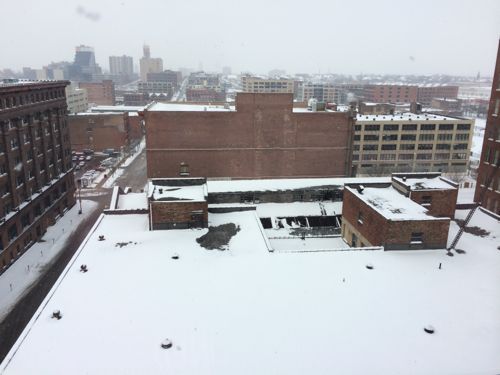
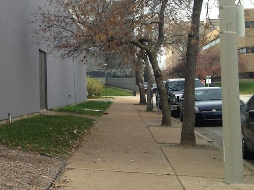
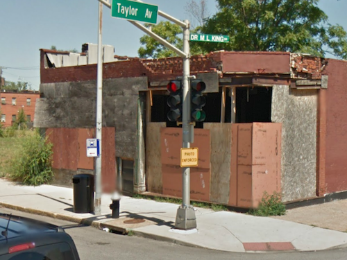
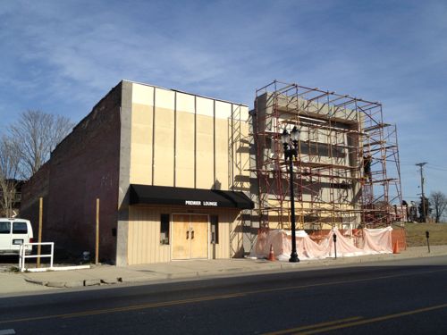
I’ve seen similar holes in the roof of the old power station on Locust, but the visible ones on the west side are nearly impossible to photograph. But yesterday I got a chance to photograph damage on the east side of the roof.
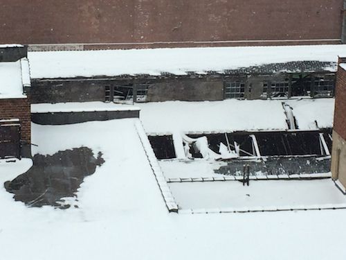
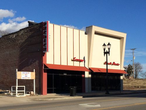
1711 Locust was a power station for the original streetcar system, it is vacant and in disrepair.Roof of 1701 Locust in the foreground, 1711 Locust attachedCropped view of damage, allowing water & snow into the building
Here’s information on the building:
This tall , one story power sub station was constructed in 1903 for the St. Louis Transit Company. Stately pilasters define three bays a center bay with three segmentally arched, very narrow tall windows and bays to each side with two segmentally arched openings. Quoins and voussoirs -frame? the segment-ally arched entrance at the lower portion of the easternmost bay. A large pediment, embellished with wreath, is superimposed in front of the parapet. The west elevation is divided into 11 bays each with two segmental1y arched blind windows. (Washington Ave Historic District)
The owner is 1711 LOCUST LLC located at Maryland Plaza, Suite 300 — the offices of Koplar Properties. The last sale on city records is for $385,000 on 12/17/2007. We can’t keep letting people allow their properties fall apart while the rest of us get cited for peeling paint.
In less than two weeks St. Louis will celebrate its 250th birthday, but 50 years ago today the city officially adopted a new flag design, replacing a 48 year old design from 1916:
The design submitted by Professor Emeritus Theodore Sizer, Pursuivant of Arms at Yale University, and now on file in the office of the City register is approved, adopted and designated as the official flag of the City. The flag with a solid red background has two broad heraldic wavy bars, colored blue and white, extending from the left top and bottom corners toward left center where they join and continue as one to the center right edge. This symbolizes the confluence of the Missouri and Mississippi rivers. Over the point of confluence a round golden disk upon which is the fleur-de-lis of France (blue) calling attention to the French background of the early city and more particularly to St. Louis of France for whom the City is named. The golden disk represents the City and/or the Louisiana Purchase. (Heraldically, the disk is a “bezant” or Byzantine coin signifying, money or simply purchase.)
The flag’s colors recall those of Spain (red and yellow or gold), Bourbon France (white and gold), Napoleonic and Republican France (blue, white and red), and the United States of America (red, white, and blue). (St. Louis City Revised Code Chapter 1.20 Official Flag)
As far as I know, the design is universally loved. For more on prior St. Louis flags see my post from four years ago.
The St. Louis flag for the last 50 years
The flag is so beautiful we have one hanging in our loft. The flag’s designer died three years later in 1967 at approximately 75 years old (Find-A-Grave). So happy 50th to our city flag and happy 250th to our city!
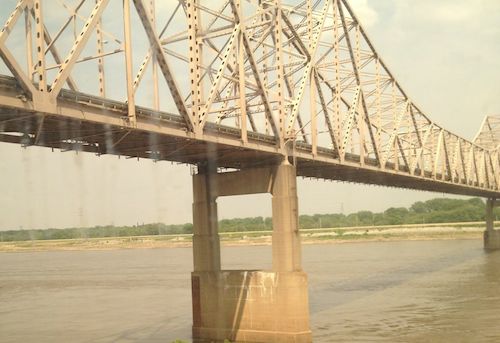
This is my 10th year blogging on Dr. Martin Luther King Jr. Day, on each of the previous nine years I’ve taken a look at Dr. Martin Luther King Drive in the City of St. Louis. Let’s start at the Mississippi River withn the King Bridge, originally known as the Veterans Memorial Bridge.
The MLK Bridge viewed from an Amtrak train in 2012
The Veterans Memorial Bridge was built by the City of East Saint Louis as a toll bridge, opening in 1951. At the time, it was the 6th longest cantilevered truss bridge in the US, and the largest cantilevered truss bridge over the Mississippi River. It carried US-40 and US-66 from 1955 until 1967. When the Poplar Street interstate highway bridge opened as a free bridge in 1967, the toll revenue from the Veterans Memorial Bridge dropped off dramatically. Eventually, both the bridge and the City of East Saint Louis would end up going bankrupt. The bridge was renamed in honor of Dr. Martin Luther King, Jr. in 1968. The structure continued to go downhill until it had to be taken over by the Saint Louis Port Authority and rebuilt in the late 1980’s, opening again in early 1989. (Source)
At that time drivers coming into St. Louis on the newly renamed bridge crossed under the elevated highway but the road split — Delmar Ave. to the left (south) or Franklin Ave. to the right (north). This 1958 aerial is clearer than the 1971 aerial. My guess is there was debate in St. Louis about which street to rename for Dr. King. This is just a hunch given the fact it wasn’t until 1972 that part of Franklin Avenue and Easton Avenue were renamed to honor Dr. King. I hope to do some research on the naming process before MLK Day 2015.
MARTIN LUTHER KING DRIVE (E-W). (Official designation is DR. MARTIN LUTHER KING DRIVE.) Following the route of the early trail from St. Louis to St. Charles, this street was officially named St. Charles Rock Road in 1865 and renamed Easton Avenue in 1881 to honor Rufus Easton, an early St. Louis postmaster. It received its present name following the assassination of the Reverend Martin Luther King, Jr., in 1968. King won a Nobel Prize in 1964 for his work to gain full civil rights for black Americans.
EASTON AVENUE (E-W). Honored Rufus Easton, who was named St. Louis’ first postmaster in 1805. He also served as Missouri’s first attorney general and gained recognition as one of the leading lawyers of his day. The name Easton still occasionally appears on city street maps although Easton Avenue is now known as Dr. Martin Luther King Drive. (St. Louis Library Street Index):
Just a few years later we began removing blocks of Dr. Martin Luther King Drive, first the two blocks were between 7th-9th for the Cervantes Convention Center, which opened in 1977. This cut off the ability to drive directly from the King Bridge onto MLK Drive.
There are now several groups working in the Wellston Loop area, each with the stated goal to revitalize the area. Their strategies are diverse and not entirely compatible with each other. Over the next year I plan to talk with the various players, asking each why they think their strategy will be successful.
Just a few blocks west of my loft, a St. Louisan died 100 years ago. I enjoy these things because they send me on a chase looking for information and places to photograph.
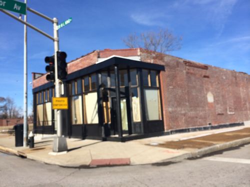
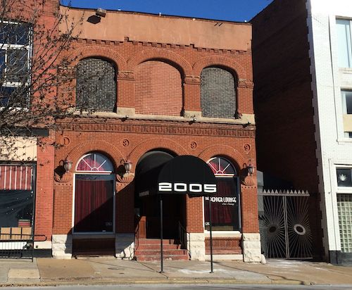
The Pepper Lounge now occupies 2005 Locust St, city records show the building was built in 1890; click image for map
Here’s what caught my attention back in February:
Manufacturer of the first x-ray plates Miles Ainscough Seed
Born February 24, 1843
Died December 14, 1913 [Note: Seed’s memorial on Find-A-Grave says he died ten days earlier, on December 4, 1013.]
Residence: The M.A. Seed Dry Plate Company worked from the building at 2005 Locust
Born in Preston, England, Miles Ainscough Seed came to St. Louis in 1865 to search out better scientific opportunities, and he began working in a photographic gallery. He worked in his spare time simplifying and the process for producing photographic negatives. He formed the M.A. Seed Dry Plate Company in St. Louis in 1882, and began to manufacture his new photographic dry plates and film. Among other innovations such a positive celluloid films and lantern slides, Seed produced the first dry plate sensitive enough to be used for x-rays and astronomical images. His company was extremely lucrative, and in 1902 he sold it to the Eastman Kodak Company of Rochester, New York. (STL250 on Facebook)
Ok, so maybe he died 100 years and 10 days ago. I did find some research on him but it uses Find-A-Grave as a reference on the date of death. I’ll need to look up the death certificate to know for sure.
I did find information on the Miles A. Seed Carriage House, listed on the National Register of Historic Places around 1986:
The carriage house dates to the ownership of the property by Miles A. Seed, who acquired it in 1887 and retained ownership until 1910. Born in England in 1842, Seed began a career as a portrait photographer in St. Louis after the Civil War. By the early 1870s he began manufacturing photographic supplies, and in 1883 he incorporated the Miles A. Seed Dry Plate Company specifically to be located in the village of Woodland. Woodland was a train stop that gave its name to a diffuse community later to become the City of Jennings. It was an attractive location for the fabrication of photographic plates because of its clean air and pure water. The success of Seed Dry Plate caused the whole community to prosper. In its field the company rivaled George Eastman of Rochester, New York, and by 1902 the threat of ruinous competition with him led Seed Dry Plate to sell out. In 1913 operations were moved to Rochester, but by then Miles Seed had moved on to new endeavors in Westchester County, New York. (PDF)
Sadly the Queen Anne carriage house was razed sometime between 1986 and 2002.
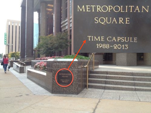
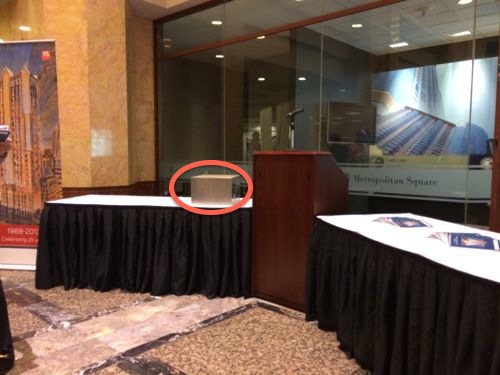
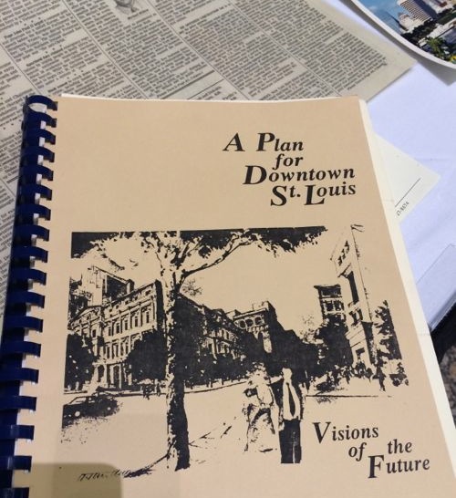
August 2013It was retrieved from the exterior location and opened in the lobby on November 20, 2013. Click image to view 10 minute video.One of the items was “A Plan for Downtown St. Louis: Visions for the Future”
The time capsule box was to be refilled and placed back into the front planter for opening in 2038. If I’m still alive then I’d like to attend. January 20, 2014 marks the 25th anniversary of the opening of the building.
AARP Livibility Index
The Livability Index scores neighborhoods and communities across the U.S. for the services and amenities that impact your life the most
Built St. Louis
historic architecture of St. Louis, Missouri – mourning the losses, celebrating the survivors.
Geo St. Louis
a guide to geospatial data about the City of St. Louis

 Manufacturer of the first x-ray plates Miles Ainscough Seed
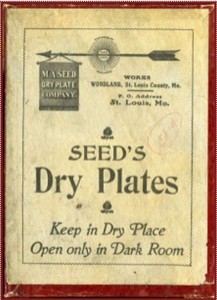 I did find information on the Miles A. Seed Carriage House, listed on the National Register of Historic Places around 1986: