Home » Downtown » Recent Articles:

Examining the St. Louis MLS Stadium Site Plan, Part 1

November 4, 2019 Downtown, Featured, Planning & Design Comments Off on Examining the St. Louis MLS Stadium Site Plan, Part 1

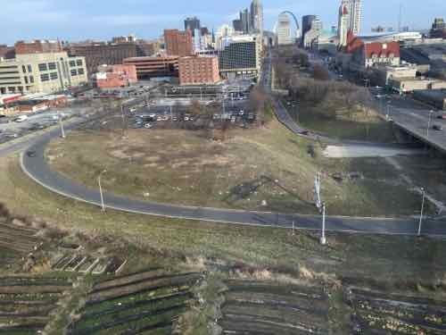
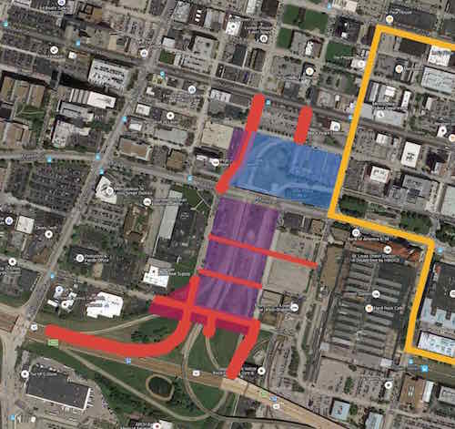
Last week we finally saw the proposed site plan for the new Major League Soccer (MLS) stadium. It’ll be exactly where I suggested in February 2016, where I said it would be a month ago —  northwest corner of 20th & Market.

Site plan for the proposed MSL stadium published by the Post-Dispatch last week. The top is north at Olive. Union Station its in the lower right corner. The new stadium is at the top, with two practice fields south of Market — immediately east of a new hotel being built along 22nd Street.

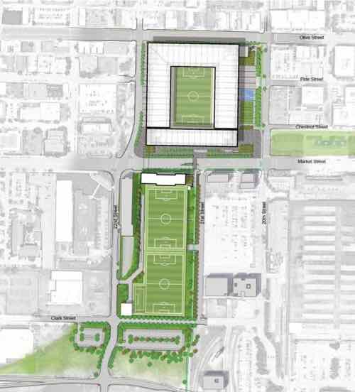
As I said last month, I thought of a smaller structure stopping at Pine on the north. But I see how more space is needed so it will go another block north, to Olive. This means razing a few buildings and relocating businesses. Understandably, one is refusing.

The owner of JR Market at 2020 Olive doesn’t want to relocate

Many, including myself, thought they’d build south of Market Street like the prior MLS group proposed. However, the site I proposed in February 2016 makes much more sense. The MLS prefers urban settings and the location north of Market gives them instant urbanism on all sides — plus two blocks of frontage along Market. South of Market there is no urbanism. None.

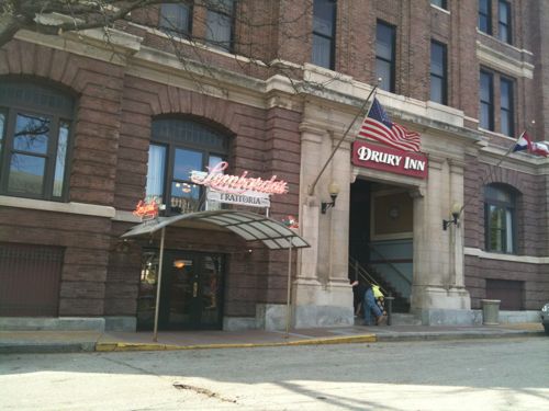
Ok, for a brief moment on 20th Street you’ve got Union Station’s train shed with new Farris wheel on one side with the old railway YMCA, now a hotel & restaurant, on the other. But a new stadium south of Market couldn’t be close to this single spot.  Granted, if done right urbanism could build up around a new stadium south of Market.

Former railroad worker YMCA on 20th Street

Wisely, they’ve opted to fill the hole in the middle of existing buildings north of Market. The new stadium will be surrounded on all sides by multi-story structures. There’s enough surface parking that it isn’t ideal urbanism, but it’s significantly better than south of Market.

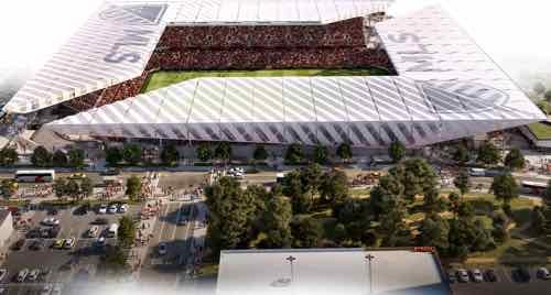
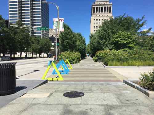
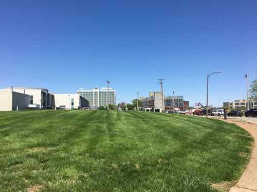
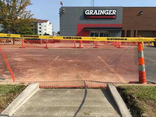
Today I want to begin to critically examine their site plan, discuss street grid changes, parking, and look at future development potential of the surroundings. The new stadium is square but one can argue the south side, facing Market, is the primary facade. The east side, facing 20th is a close second. Due to the amount of land area, we’ll start with the area south of the stadium.

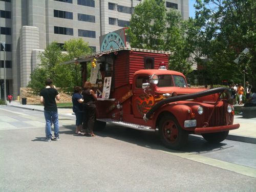
I’ll admit in February 2016 I hadn’t considered practice fields. I saw the area south of Market being filled with offices, housing, etc.  The area devoted to practice fields is largely dead space, perhaps school groups could use them. This keeps the team owners from having practice fields and team offices elsewhere in the region  — as was the case with the Rams NFL team.

This portion of the site plan shows Market Street (top) downtown to 40/64, between 21st and 22nd. The plan shows new points to cross Market at both 21st & 22nd. It also shows 22nd getting straightened and Clark Street connecting 20th to 22nd — for the first time in decades.

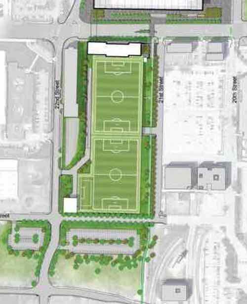
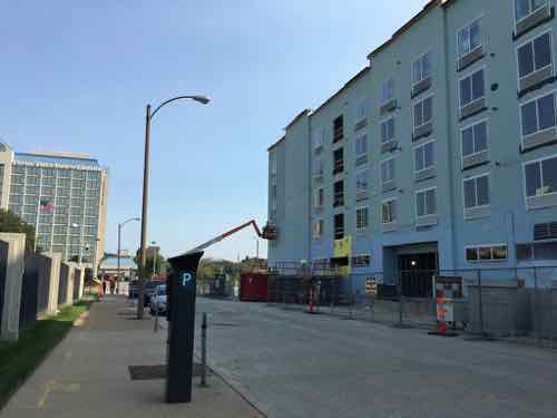
I like a number of things about this design. As I thought in 2016, the stadium will be an excellent terminus to the Gateway Mall. The site plan shows a new building facing Market across from the stadium, north of the practice fields. I assume this will hold a team store, offices, etc. If this is more than a single story in height it and the stadium will give this stretch of Market a feeling of urbanism — enclosure. Combined with the new hotel finishing up at 22nd Street this will do wonders for the area.

In time the two buildings on Market between 20th & 21st will likely get replaced by multi-story structures. The rest of this block is surface parking for Union Station. I’d like to see a center parking garage with sidewalk-level storefronts and perhaps at multi-story building at the south end.

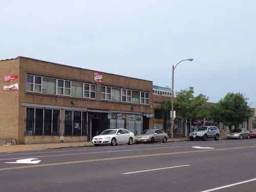
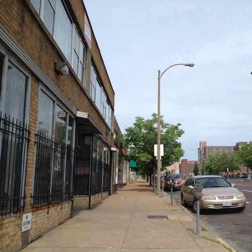
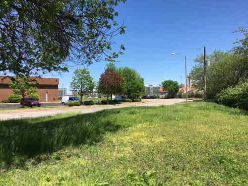
Replacing the two buildings and filling in the surface parking lots in the block bounded by Market, 20th, 21st, and Eugenia Street will not happen overnight — but I do think it will over time. It should at least.

As mentioned above, Clark Street will connect between 21st and 22nd — something it hasn’t done in decades. The site plan shows surface parking right now, a placeholder for future development. Hopefully this new Clark will be designed to permit on-street parking on both sides. Not sure what will get developed on the land between Clark and 40/64 — hopefully multi-story.

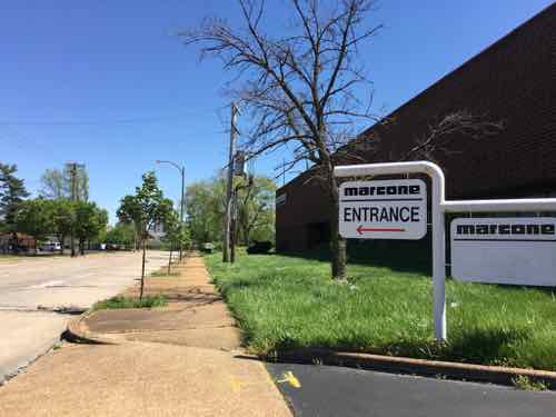
You’ll also notice 22nd street continuing south to the interstate. Changes have been in the works since Paul McKee first named the 22nd Interchange site as one of his four jobs centers. MoDot has been planning major changes to interstate entry exit points.

The pink shows new highway on/off ramps. A person driving westbound on 64 that wants to go north or south on Jefferson would exit at 22nd but stay on the side road until they reach Jefferson. A new bridge would extend 22nd Street over 40/64 to reach Scott Ave. Click image for original source — h/t to Scott Ogilvie

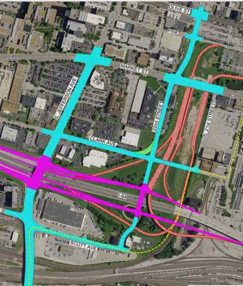
I love the new 22nd Street connection over the interstate! Hopefully it’ll also include pedestrian accommodations. It’s unclear from MoDot’s materials what will become of the state-owned land south of 40/64.

One of the benefits of developing the 22nd interchange site is the current hole makes underground parking significantly cheaper compared to excavating an area filled with dirt, foundations, utilities, etc. The MLS team plans to use the area under the two practice fields for team/staff parking. Just guessing before the first match we’ll learn that luxury box ticket holders will also get access to underground parking.

I suspect they’ll also have locker rooms, kitchens, etc under the MLS stadium itself. I also expect the area under the stadium will be connected to the parking under the practice fields. Given the area is totally open now this is a very easy proposition.

This photo under Market was in my February 2016 post. I didn’t see a need to connect the north & south sides under Market but it makes sense knowing the MLS team will be on both sides.

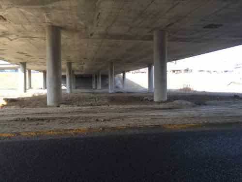
The connection won’t be the full width of what has existed for decades, perhaps a nice hallway for players, owners, and staff. A second service connection is likely for food service, rubbish removal, etc.

New Fairfield Inn being built on the former site of Harry’s restaurant. This view looking north on 22nd was taken in early September. FBI’s St. Louis offices on my left.
The NW corner of 22nd & Clark is now grass. The seamless curve of 22nd into Clark made this difficult to develop. It’s owned by Grainger next door.
Grainer Industrial Supply is a simple one-story structure set back from Clark.
I was happy to see in September they were making site changes for a pedestrian connection to the public sidewalk on Clark. They own the building and land, I can see them getting an offer someday that’ll entice them to move. Dense urban infill will eventually occupy this site.
Looking east as Clark curves north to become 22nd. This view will be radically different in a couple of years.
Marcone Appliance supply was located on Clark, backing up to 40/64. They’ve already relocated and their property is for sale. Once Clark continued east to 21st and 22nd is extended over the interstate this will be a potentially good site for new development.

Part 2 of this series will explore another direction around the proposed MLS stadium.

— Steve Patterson


St. Louis’ MLS Stadium Will Be Built On Site I Proposed In February 2016

October 7, 2019 Downtown, Featured, Planning & Design, Popular Culture Comments Off on St. Louis’ MLS Stadium Will Be Built On Site I Proposed In February 2016

In 2015 St. Louis officials were proposing razing historic buildings/districts in the North Riverfront area, between Laclede’s Landing and the Stan Musial Veterans Memorial Bridge, to build a new NFL stadium to keep the Rams in St. Louis.  It never happened, in early January 2016 the Rams officially applied to relocate to Los Angeles.

The next month it was announced a group had formed to attempt to get a Major League Soccer (MLS) team in St. Louis — they were scouting for sites. I’d opposed the North Riverfront as a site for an NFL stadium, I also felt it wasn’t the best site for a smaller MLS stadium.

I weighed in:

The site they shouldn’t consider is the North riverfront one previously targeted for a significantly larger NFL stadium — we shouldn’t tear down buildings when we have vacant land available. We have land, mostly state owned, without any buildings and a target for redevelopment for years already. I’m talking about the 22nd Street Interchange area — an area on the West side of downtown I’ve written about numerous times over the 11+ years.

In that February 8, 2016 post I imagined fitting a stadium in between Pine, 20th, Market, and the hotel to the west. Busch Stadium fits in a space 2 blocks x 3 blocks, so a MLS stadium with less seating should fit in a smaller footprint. I emailed my post to a contact at St. Louis Development Corporation (SLDC)

Looking West from the Pear Tree Inn at 2211 Market in February 2016.

That first group proposed a stadium in the 22nd Street Interchange area, but south of Market Street, not north. I don’t know if they were already looking at this location prior to my post & email, but the entire year before development officials were so focused on the North riverfront I can’t help but think they wanted to stick with what they knew and had so much time invested in.

When the state & city residents opposed public funding a of soccer stadium the ownership group was out.  When the current ownership group entered the picture in October 2018 they’d privately finance a stadium in the 22nd Street Interchange area many, including myself, assumed it’d also locate south of Market St.  In April 2019 they showed some renderings, but no site plan. Again, many of us assumed the larger area south of Market St.

I can now guess this view is looking east. The parking garage roof seen at the bottom is the existing Pear Tree Inn garage. Pine, to the left of the garage, would not go through from 20th to the new 22nd Street

We were wrong, it will be the area I’d proposed in February 2016! However, instead of stopping at Pine the site will go one more block north to Olive. A few buildings would be razed, businesses are already being forced to relocate on short notice.

The tenants of these buildings on Olive have been told to vacate. May 2013 photo
On the sidewalk in front of the buildings that’ll likely be razed. I’ve been a fan of the 2-story buff brick building for years. May 2013 photo.

I reviewed the ownership records for these and the remaining buildings to the west, none showed a recorded change of ownership — yet. I don’t like seeing businesses and/or residents forced to move. Hopefully they’ll be offered a financial package to compensate for their time, trouble, and loss of business.

I’m also not a fan of closing streets, though Pine has been an awful one-way street for decades. Hopefully the one-way couplet (opposite directions) of Chestnut & Pine will both be returned to two-way traffic as a result of the existing on/off ramps going away.

I still want to see an official proposed site plan. Despite holes from parking lots, Olive has clung to a urban feel with multi-story buildings on both sides. I also wonder if we’ll see a revised I-64 on/off ramp that ends at Market Street — I’d be disappointed, but not surprised.  Even if that happens, a lot less land could be devoted to highway on/off so the area would support additional development and tax revenue.

— Steve Patterson


Time For St. Louis To Decide What The Area Around A Future MLS Stadium Should Look Like, How It Should Function

August 16, 2019 Accessibility, Downtown, Featured, Planning & Design, Walkability Comments Off on Time For St. Louis To Decide What The Area Around A Future MLS Stadium Should Look Like, How It Should Function

On Wednesday a long expected, though still unconfirmed, report indicated St. Louis will be the next city to get a Major League Soccer (MLS) expansion team.

Major League Soccer will award an expansion franchise to St. Louis, a source close to the prospective ownership group has confirmed to ESPN. The deal is expected to be announced as soon as next Tuesday.

The St. Louis Post-Dispatch was first to report that St. Louis will be MLS’s 28th team.

The ownership group, MLS4TheLou, declined to directly comment on the reports, issuing the following statement: “Major League Soccer is responsible for the timing of any announcements around League expansion, but we remain confident St. Louis has made a strong case for a team.”

MLS didn’t immediately respond to a request for comment.” (ESPN)

Now that it looks likely the team and new stadium will happen we can delve more seriously into the design of the stadium and, more importantly, the surrounding blocks.

My map of the area from 2016

Nearly four months ago we got our first look at the proposed stadium, here’s how I ended my post then:

Here’s what I think about the site, both north & south of Market Street:

  • The stadium & new buildings should take advantage of the existing hole for basement or underground parking.
  • Market Street between 20th & 21st is a deteriorating bridge, it should be removed. Under it can be filled in with foam so a new road/sidewalks can be built at grade.
  • Market Street should be redesigned to be friendly to pedestrians. This means narrowing the road (fewer, narrower lanes) and more crossing points. Right now there’s a crosswalk at 20th and at Jefferson –this is nearly a half a mile without a crossing.
  • Hopefully the changes at Union Station, including the upcoming Farris Wheel along 20th Street, will mean easier access under the train shed between the Union Station MetroLink platform on the East side of 18th to the new MLS stadium.
  • Metro will need to rethink downtown circulation with a revised Union Station, a MLS stadium, and hopefully active surroundings.
  • Pine & Chestnut have been a one-way couplet for decades. Once the on/off ramps to/from I-64 are gone both streets should be returned to two-way traffic. The revised Soldiers Memorial, however, has only one eastbound lane on Chestnut between 13th-14th.  Chestnut has our only protected bike lane.

I’ll probably think of more issues, hopefully the site planning being done now will address at least some of these.

My views haven’t changed, but I do have some additional thoughts now that we’re getting close. Most are questions, in no particular order:

  • We still need to see a proposed site plan. What is the current ownership of the current land?  How much city & state property will exist beyond the stadium boundaries? Is the stadium site too small? Too large?
  • Because not everything will get built by the date of the first match, we need to think long-term. What might this large vacant hole look like in 10-15-20 years? What do we as a community want it to look like?
  • I think minority businesses should get work from infrastructure improvements, stadium, and new construction adjacent to the stadium. Big investments are being made, every part of the community should benefit.
  • We need to plan an area larger than the stadium — I-64 on the South (since it’s a hard boundary), the West side of Jefferson (since the city is looking at Jefferson changes to accommodate the coming NGA West headquarters further North, to the North I’d say at least include Locust. To the East Union  Station is a hard boundary but there are development opportunities surrounding the historic train station (16th, perhaps 14th).
  • Housing should be included within the larger area described above. This should be at all price points from low-income to high-end. It should include purchase & rental.
  • Hopefully we can agree that new low-density uses like gas stations & stand-alone fast food restaurants would be inappropriate.
  • Pedestrian circulation needs to be considered as much, or more, than vehicular circulation. We’re going to have lots of visitors coming into town for future MLS matches, they need to be able to fly into St. Louis, take MetroLink to Union Station, easily walk to their hotel, walk from their hotel to the stadium, patronizing local businesses along the way. Will pedestrians be able to freely walk from 18th to 20th through the Union Station train shed, or will they be forced to go up to Market Street?
  • New infrastructure (water, sewer, electric, etc) needs to be planned for future development. Initial surface parking lots should be development sites in the future. For example, we shouldn’t need to move a water line just five years later.
  • Unlike Ballpark Village, the surroundings shouldn’t all be owned by the team ownership. It shouldn’t even be just one entity. A different company might work each direction from the stadium. The community plan, hopefully with form-based zoning, will ensure they all work to create what we want this area to become over time.
  • How can we make the area active on days without a match? One option might be having one street where restaurants are concentrated on both sides. Or maybe just at all corners?
  • How do we create a good West terminus to The Gateway Mall? Currently there’s a little bit of the linear park west of 20th Street.  Do we end at 20th? End at a new 21st?  At a new 22nd?
  • Will there be a place for match-day events? A side street that gets closed? A plaza adjacent to the stadium? The west end of The Gateway Mall?
  • Though this area is part of the Downtown West neighborhood, the stadium area needs a good name. This will help identify this district.

My fear is the rush to get a new stadium built mistakes with long-term consequences will be made. We’ve got one chance to do this right.

— Steve Patterson


Ninth Street Needs To Be Unblocked Through Citygarden

July 5, 2019 Downtown, Featured, Parks Comments Off on Ninth Street Needs To Be Unblocked Through Citygarden

Ninth Street through Citygarden was, to my knowledge, never officially vacated by the city.   The late Peter Fischer of the Gateway Foundation just decided it would be closed. He

East block of Citygarden, June 2011

St. Louis loves closing streets. A block here, a block there. The cumulative effect has been disastrous for the city, especially downtown. We have one-way streets but with blocks either closed or some two-way. It’s confusing to residents and visitors.  Everyday at the Downtown YMCA I see cars going to wrong direction on Locust St.

West block of Citygarden on September 8, 2014 @ 8pm

Thankfully Citygarden was designed to have 9th Street open to vehicles.

The site plan clearly shows a narrow 9th Street dividing the two blocks.

At each end rain garden curb bulbs narrow the street to just two lanes — this is a natural message to drivers to slow down. In the center is a crosswalk. On each side is a passenger drop-off point. This is helpful for the elderly and disabled.

The Fire and Ice Cream Truck on 9th Street in 2011

One thing everyone involved failed to do is provide a pedestrian signal for those crossing 9th on the wide “Hallway” that’s supposed to eventually extend the length of the Gateway Mall.

One reason they closed 9th is they didn’t figure out how to let pedestrians using the “hallway” to know when it was safe to cross 9th

Spend tens of millions but not even consider the basics of pedestrian safety.

Most who took the recent non-scientific Sunday Poll thought 9th Street should remain closed.

Q: Agree or disagree: 9th Street through Citygarden should remain closed to vehicle traffic

  • Strongly agree: 16 [41.03%]
  • Agree: 6 [15.38%]
  • Somewhat agree: 2 [5.13%]
  • Neither agree or disagree: 1 [2.56%]
  • Somewhat disagree: 2 [5.13%]
  • Disagree: 7 [17.95%]
  • Strongly disagree: 5 [12.82%]
  • Unsure/No Answer: 0 [0%]

It could still be closed on nice weekends when it’s busy and during special events. It would be nice to be able to exit I-64 at 9th and be able to take it all the way into Columbus Square neighborhood to go home.

Still need to figure out how to fix the lack of pedestrian signal though…

— Steve Patterson


My Visit To Fields Foods in Downtown West

July 1, 2019 Downtown, Featured, Retail Comments Off on My Visit To Fields Foods in Downtown West

Back in April I visited a new grocery store located in a building I could see from my windows/balcony for over 11 years. Naturally a very convenient grocery store didn’t open until after I moved.

December 2008: the then-CPI building on the left as seen from my balcony

The CPI building at 17th & Washington is now known as The Monogram. It has apartments on the upper floors, and now a Fields Foods on the ground floor.

A new ramp on Washington Ave for ADA accessibility
Good produce selection, right at the entry.
Deli and all the usual items you’ll find at their original location on Lafayette.

I don’t recall now what I bought, but I do remember they hadn’t been open long and they had ApplePay working — very important to me.  Like their original, prices on some things are lower than other stores, while others are higher. When I was car-free I would’ve gladly paid a little more for the convenience.

I suspect many of my old neighbors will continue to shop where they had been if they’re already out in their cars. If you’re used to driving to ALDI or Costco to stock up you’re not going to like shopping here. However, if you’d rather make frequent walking trips then this will be a great addition to the neighborhood.

I wish them well!  Fields Foods’ Downtown West location is at 1706 Washington Ave.

— Steve Patterson


Advertisement


[custom-facebook-feed]

Archives

Categories

Advertisement


Subscribe