Home » Downtown » Recent Articles:

Richard Serra’s ‘Twain’ Sculpture Dedicated 40 Years Ago, Needs To Be Lighted

May 1, 2022 Downtown, Featured, Popular Culture Comments Off on Richard Serra’s ‘Twain’ Sculpture Dedicated 40 Years Ago, Needs To Be Lighted

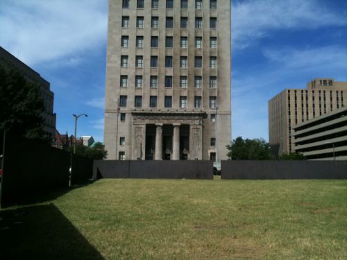
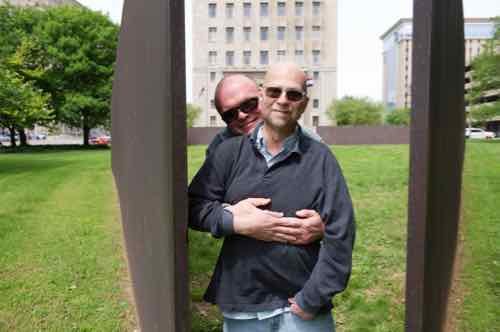
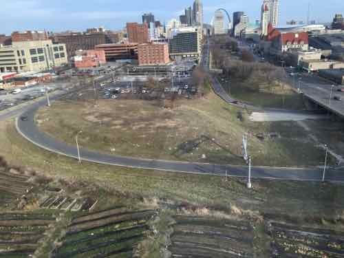
Every five years I post about Twain. Not Mark Twain, but the COR-TEN steel sculpture by Richard Serra (1938 – ) It was inaugurated 40 years ago today — May 1, 1982. St. Louis loves to hate this sculpture, bashing it is a group bonding experience. I like it, partly because so many don’t.  I also like how it feels to be inside, or looking into or through the openings.

Looking west inside ‘Twain’

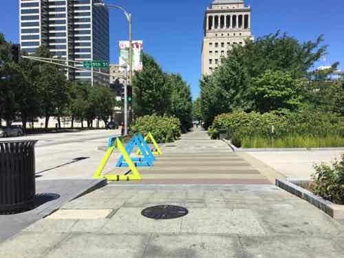
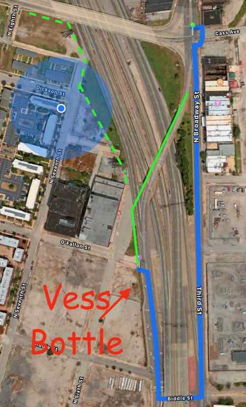
Ever since Citygarden opened across 10th Street in 2009 I’ve felt we need to connect the two — extend the wide “hallway” as envisioned by the Gateway Mall master plan.  Install new wider sidewalks on the three other sides.

The wide hallway connecting the two blocks of Citygarden at 9th & Market. One reason they closed 9th is they didn’t figure out how to let pedestrians using the “hallway” to know when it was safe to cross 9th. A problem that would need to get solved at 10th.

Definitely install new lighting like Twain had in 1982. Well, not big fixtures on the ground that make it hard to mow the grass — new compact LEDs flush with the ground.

At the 1982 opening the lighting was extensive, the outsides were washed in light, inside there was a light on each side of each opening. Still image from video on opening day — click to view 4:09 minute video on YouTube.

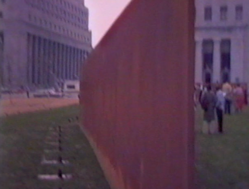
Five-10 years ago a light manufacturer was willing to temporarily mock up what new modern lighting could look like. Art patrons in St. Louis weren’t willing to cover the cost for security for the week so the installation never happened.

So Friday night my husband and I went to Twain and used an iPhone flashlight on bright to simulate what just one light would look like.

The spot on one section was created with one iPhone X, just imagine what proper LED landscape lighting would look like all the way around the perimeter.
A closer view of the light.

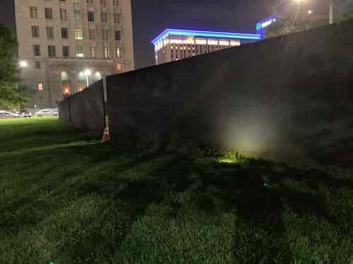
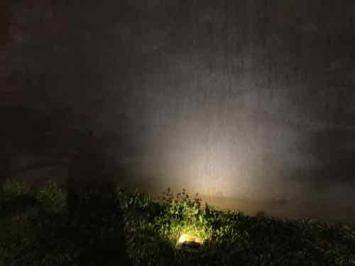
The results were worth the effort. Proper lighting could potentially change perceptions about this sculpture.

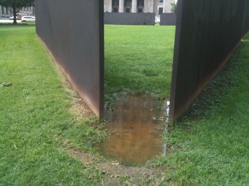
Another problem is the grass is very uneven, and the openings get very worn.

After raining the openings are a mud pit.

I have some ideas about a solution, but I’m very curious what the artist would say. He didn’t want any formal paths because he wanted people to be able to approach the sculpture from any point. I’d also be interested in what landscape architects would come up with, perhaps through a competition.

Again, I really like this sculpture. So much so that a year ago when Lindy Drew from Humans of St. Louis was taking my picture for post I selected Twain & Citygarden as the locations.

Steve & David, May 2021.

A non-profit arts organization is needed to submit an application to the Gateway Foundation to fund lighting, other work. Someone please make this happen.

— Steve Patterson


MetroLink Escalators “Temporarily Closed” For Years

April 18, 2022 Accessibility, Downtown, Featured, Public Transit, Transportation Comments Off on MetroLink Escalators “Temporarily Closed” For Years

Escalators are great, very helpful to those who find stairs difficult.  However, like elevators, they’re expensive to install and maintain. Escalators exposed to the elements are even more challenging to keep in operation.

When our original light rail line opened in 1993 two stations were located within an old freight tunnel under the central business district (CBD). The Convention Center and 8th & Pine stations were designed with stairs, elevators, and escalators. Because the tunnel is narrow the tracks are in the center, the passenger platforms are on both sides — one per direction of travel, east or west. This meant a total of four elevators and four pairs of escalators — all exposed to elements to a degree.

When the Shrewsbury (Blue) expansion line opened in 2006 its three underground stations had stairs, elevators/ramps — no escalators.

In 2018 & 2019 I’d frequently see ThyssenKrupp maintenance people working on the Convention Center escalators, or at least their service truck on the public sidewalk near the westbound entrance/exit. April 1, 2019
Here’s the same location on November 2, 2020
Another view, with parts visible. November 2, 2020
View from the platform level. November 2, 2020
The big plywood barricade has been gone for quite a while, but the escalators remain out of service. March 7, 2022
The eastbound escalators at 8th & Pine have been a similar story. Note access to the elevator is on the right, back — between the escalators and stair. April 21, 2021.
The street entrance of the eastbound 8th & Pine station after the plywood construction barricade was constructed, steps & elevator are accessible. March 1, 2022

I search all Metro press releases from 2019 through the present, only one mentioned escalators in the subject/summary.

From May 3, 2021:

Rehabilitation work on the westbound escalator at the 8th & Pine MetroLink Station in downtown St. Louis begins on Tuesday, May 4. During this project, the station’s westbound elevator will remain in service, however, the accessible pathway to the westbound side of the 8th & Pine Station (near Pine Street) will have to be closed temporarily.

MetroLink riders who are traveling to or from the 8th & Pine Station and use a wheelchair or mobility device may need to make adjustments to their commute, as it will be necessary for riders to use stairs (located near Chestnut Street) when entering or departing the westbound side of the 8th & Pine Station.

The escalator rehabilitation work is expected to take approximately three months to complete. (Source: Metro)

The above press release was issued a week after I followed up with Metro again since I hadn’t received any specifics from my inquiry on December 28, 2020. Receipt of my original inquiry was acknowledged but I never received anything. Just the one press release, above.

Since I use my power wheelchair when using transit why do I care if the escalators aren’t working?

Well, it looks bad to have something temporarily non-functional for days, weeks, months..years.

What do I hope to accomplish with this post?  I want all the escalators either in good working condition — or I want them removed and replaced with fixed stairs (I can’t speak to concerns of those who have a hard time with stairs). It obviously won’t happen quickly, but steady progress needs to be demonstrated.

It looks very bad for visitors to see out of service signs, but it’s even worse when returning visitors say “oh yeah they were out the last two years I’ve visited.”

— Steve Patterson


Rethinking 2211 Market Street (Pear Tree Inn)

March 21, 2022 Downtown, Featured, MLS Stadium, Planning & Design Comments Off on Rethinking 2211 Market Street (Pear Tree Inn)

As I outlined two years ago, the blocks around new Centene Stadium will most certainly change in the coming years, decades. We’ve already seen some buildings on Olive be razed for the stadium, and more for a new garage. These weren’t architectural masterpieces, but they were urban. Hopefully it’ll be a good trade off.

One building I want to see razed, or significantly altered, is the hotel at 2211 Market Street (2.78 acres). Currently it’s officially known as the “Pear Tree Inn Near Union Station.” With the new major league soccer stadium nearing completion next door I think they’ll rename the hotel to reflect the ideal proximity. I’d like to bigger change — a complete rethink.

Photo of Pear Tree Inn
The 11-story hotel was built in 1965. It is set back from Market Street behind parking. It doesn’t orient to any of the three streets (Market, 23rd, Pine) that has bordered it since new.
Photo of low parking garage behind Pear Tree Inn
The 2-level parking garage to the north of the tower was built at the same time.

One of the first things I like to do is look back at what existed before — especially streets & alleys. Not that I’d necessarily want to recreate what existed over a hundred years ago, I just find it helpful.

1909 Sanborn fire insurance map
In February 1909 we can see Chestnut between Market and Pine, 22nd on the east, 23rd on the west. City blocks 914 & 915.
Aerial view with interchange east of hotel
For decades is was next to what was planned to be the 22nd St Parkway. This interchange was all that ever got built.
Aerial view with stadium construction east of hotel
Now the new MLS stadium is going up, and 22nd Street will once again exist!

Interestingly, the little bit of land between the east side of the hotel and the new 22nd Street is deeded in several small parcels, at least one to TKFC Properties, LLC in Moscow Mills, MO. The accessor classifies it as “9900 (OTHER UNDEVELOPED LAND AND WATER AREAS, NEC)”, so perhaps it’ll collect runoff water. Seems too valuable for water retention.

I strongly dislike this hotel and parking garage. I suspect the owner, Drury Hotels, is contemplating their options now that their real estate has a prime spot near the MLS stadium, and a higher valuation. The big question is what are the various ways to rebuild or start over?

I believe in reusing existing structures, so the first option would be to look at adding a new tower perpendicular to the existing one so hotel rooms on the east side could look toward the stadium and downtown. The roof of a new tower could contain a rooftop restaurant/bar with outstanding views. A new urban entrance facing Market, 22nd, or Pine. Some sort of drive though for check in that doesn’t block the many pedestrians that will soon be in this area.  Parking will need to go somewhere, preferably underground.

Other options involve razing the tower and garage, completely starting over from scratch. If they get the little bit of land between the existing lot and 22nd Street the site will be bordered by four streets — it needs to acknowledge all of them.

Reconstructing Chestnut Street needs to be considered. Chestnut still exists between 23rd and Jefferson Ave. so this would help reconnect the original street grid. We would then have two parcels, with the north larger than the south.  Perhaps a parking garage in the center of the larger parcel, wrapped in hotel rooms, apartments, and/or offices? The new block of Chestnut might be a full public street, a public walkway, or a private walkway that’s generally open to the public. I can see a Chestnut walkway being filled with outdoor dining, a new building(s) on the south side blocking the hot sun.

My one time in the hotel was to get this photo from the hallway of an upper floor. This was the view I used in my February 2016 post when I called for this to be the site of a new stadium — over six years ago! Click image to view post.

I’m confident this site will look dramatically different within a decade, just not sure how it’ll look. If I’m still around when something happens I’ll be sure to post about it.

— Steve Patterson


This Is Our Chance To Reconnect Two Neighborhoods Long Separated By Highways

February 17, 2022 Downtown, Featured, North City, Planning & Design, Transportation, Walkability Comments Off on This Is Our Chance To Reconnect Two Neighborhoods Long Separated By Highways

Urban highways & interstates allow drivers to get from point A to point B quicker than had they taken surface streets, but they’re also a major divider between the existing neighborhoods they cut through.  In the late 1950s the downtown’s 3rd Street Parkway was being extended north, eventually connecting with the new Mark Twain Expressway (aka I-70/I-44) in July 1961.

I live on the west side of the highway, but I can stand in my kitchen and see Broadway & Cass, on the east side of the highway. I know first hand how the highway divides the historic north riverfront from my neighborhood, Columbus Square.

Looking south from the Cass Ave bridge over I-44, June 2020. The lane center is a southbound express lane, to the right is the express lane exit ramp to southbound Broadway.

Ideally we’d remove urban interstates and weave our neighborhoods back together, but that’s never going to happen. What should happen is when we rebuild crumbling infrastructure we add connections civil engineers in the 1950s never considered at the time the highways were planned.

The same view Monday with southbound Broadway bridge and the exit ramp gone.
The blue oval is the southbound Broadway bridge, the red X is where Csss & 7th were connected until construction began for the Stan Musial Veterans Memorial Bridge. Post-Dispatch July 9, 1961, p161.

The distance from Broadway & Cass to Broadway & O’Fallon is only 2/10 of a mile, but the distance required for the last 60 years has been double that — 4/10 of a mile.

The Missouri Department of Transportation supports pedestrian facilities:

MoDOT works with planning partners to create transportation facilities that work for all users because we value bicycle and pedestrian travel. Accommodating for bicyclists or pedestrians may be as simple as providing a well-designed road that all road users share or as complex as a separate-grade structure, such as a bridge. Developing appropriate facility design for nonmotorists depends on a variety of geometric and operational factors that are inter-related, such as available right-of-way, projected traffic counts and adjacent roadway design speeds.
 

We strive to integrate nonmotorized travel into the existing system to provide connections where none exist to promote efficiency and to focus on a primary concern—the safety of those who depend on walking or bicycling to reach their destinations. (MoDOT)

Unfortunately MoDOT failed to accommodate the needs of cyclists and pedestrians in the replacement. This is a huge mistake — it’ll be another 60+ years before we get another chance to reconnect these areas.

View from Broadway near Cass looking SW toward Broadway @ O’Fallon (just beyond building), June 2021
The buildings on the right are part of a National Register Historic District.

You might be thinking it would be too difficult to include a pedestrian sidewalk.  The old bridge, removed over the weekend, couldn’t have easily been retrofitted. But when building the new bridge entirely from the ground up it is actually pretty easy.

Here’s the overview:

The blue circle is my location. The blue line represents the route required to walk from Broadway @ Cass to Broadway @ O’Fallon — twice as far as the direct route shown in solid green. The dashed green line is how to connect Cass to 7th & 6th streets. Apple Maps

Now let’s take a look at the old bridge and highway exit ramps.

Broadway is only one lane per direction north of Cass, but it widens to 2 right turn lanes onto westbound Cass and 2 southbound lane to continue across the highway. One lane expands to four! Apple Maps
So 2 lanes of Broadway continued over the highway. The express lane exit is one lane but the Broadway exit is 2 lanes. Four lanes continue toward Cole before getting reduced to 2 further south.

The solution is the one southbound lane of Broadway splits into 3 before Cass — one left, one right, one straight ahead. This means the same width bridge can also accommodate bikes & pedestrians. The traffic exiting the southbound express lane and the highway have plenty of length for drivers to decelerate. Rumble strips (or similar) can be used to communicate to the driver to slow down as they approach Broadway. The 2 highway exit lanes can narrow to one before Broadway. Not sure if signals are necessary or just a flashing red light and notices to yield to pedestrians.

I would like to see Broadway south of Cole to return to two-way traffic in the future, so I’d like the new bridge to accommodate 2-way traffic and pedestrians on one side.

Again, I’m trying to connect two areas that have been separated for over 60 years. Both have enormous potential for redevelopment — new construction & adaptive reuse to the south and mostly captive reuse to the north. I’d love to see football fans have pre-game drinks at Shady Jack’s Saloon and then walk down to the Dome to see the St. Louis Battlehawks when the XFL returns under new ownership.

We must use this moment to correct past mistakes!

— Steve Patterson

n


Newish Book — ‘ Recast Your City How to Save Your Downtown with Small-Scale Manufacturing’ by Ilana Preuss

December 11, 2021 Books, Downtown, Economy, Featured Comments Off on Newish Book — ‘ Recast Your City How to Save Your Downtown with Small-Scale Manufacturing’ by Ilana Preuss

It’s possibly human nature that causes us to look for a magical silver bullet to fix our cities, towns, and villages. Examples might include a sports team, corporate headquarters, even a monorail.  Lasting success is never that easy, it takes more effort.

Too many U.S. cities and towns have been focused on a model of economic development that relies on recruiting one big company (such as Amazon), a single industry (usually in technology), or pursuing other narrow or short-term fixes that are inequitable and unsustainable. Some cities and towns were changing, even before the historic retail collapse brought on by COVID-19. They started to shift to a new economic model that works with the community to invest in place in an inclusive and thoughtful way, with short-term wins that build momentum for long-term growth. A secret ingredient to this successful model is small-scale manufacturing.

In Recast Your City: How to Save Your Downtown with Small-Scale Manufacturing, community development expert Ilana Preuss explains how local leaders can revitalize their downtowns or neighborhood main streets by bringing in and supporting small-scale manufacturing. Small-scale manufacturing businesses help create thriving places, with local business ownership opportunities and well-paying jobs that other business types can’t fulfill.

Preuss draws from her experience working with local governments, large and small and illuminates her recommendations with real-world examples. She details her five-step method for recasting your city using small-scale manufacturing: (1) light the spark (assess what you can build on and establish goals); (2) find and connect (get out of your comfort zone and find connectors outside of your usual circles); (3) interview (talk to people and build trust); (4) analyze (look for patterns and gaps as well as what has not been said); and (5) act (identify short-term actions to help build long-term change). This work is difficult and sometimes uncomfortable, but necessary and critical for success. Preuss supports and inspires change by drawing from her work in cities from Knoxville, Tennessee, to Columbia, Missouri, to Fremont, California.

In Recast Your City, Preuss shows how communities across the country can build strong local businesses through small-scale manufacturing, reinvest in their downtowns, and create inclusive economic opportunity. Preuss provides tools that local leaders in government, business, and real estate as well as entrepreneurs and advocates in every community can use. (Island Press)

St. Louis still has manufacturing downtown, TUMS is the example that comes to my mind. We certainly could use more downtown and throughout the region.

This newish book has a video trailer featuring the author!

As usual, I like to use the contents to show how the author makes her case:

Chapter 1: What it Means to Recast Your City
Chapter 2: Why We Need a New Economic Development Model
Chapter 3: A Stronger Economic Development Model with Small-Scale Manufacturing
Chapter 4: Five Steps to Recast Your City
Chapter 5: Step 1: Light the Spark
Chapter 6: Step 2: Find and Connect with New People
Chapter 7: Step 3: Start the Conversation and Get Great Information from Your Interviews
Chapter 8: Step 4: Analyze the Input and Understand What it All Means
Chapter 9: Step 5: Be Impatient and Act Now

As Preuss said in the video, this book is for local leaders that want to change the economic outlook where they live.  Any of you might be the local leader to make it happen here.

You can get a link to download the first chapter emailed to you here.

Steve Patterson


Advertisement


[custom-facebook-feed]

Archives

Categories

Advertisement


Subscribe