I’ve only begun looking at the new “Metro Reimagined” bus service in St. Louis City & County, haven’t even ridden a bus yet this week. I do recall other riders discussing it last Friday at the bus stop. One woman, who also lives just north of downtown, was upset about the west end of the #97 Delmar bus getting cut in St. Louis County. It will mean more walking for her to get to work.
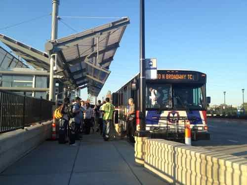
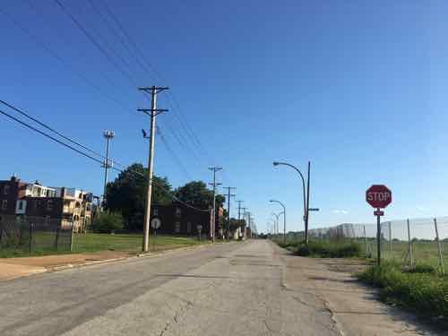
The #70 Grand MetroBus is the busiest bus line in the region, partly due to being the only route frequent service. August 2012
Here are the four tiers used to organize the MetroBus routes:
Frequent: 10 high-frequency routes offering service every 15 minutes or faster
Local: 35 routes offering 30-minute service
Community: 6 routes that provide important connections in low-ridership areas
Express: 6 routes providing direct connections with limited stops to key destinations
My first place to start was asking “Will I be impacted?” by this change. The short answer is yes — every bus rider will see changes to service. Some positive, some negative.
Moving from Downtown West to Columbus Square in December 2018 means I have fewer bus routes available — basically the #32, with the southbound #40 another 1/10 of a mile further away than the southbound #32. The northbound #32 is considerably closer than the northbound #40.
Since moving I’ve rarely used the #40, the #32 is my primary bus route. Both routes are considered “local” routes, now with 30 minute frequency during weekdays. The service was every 40 minutes, so 30 minute frequency is an improvement.
The other bus I use is the #90 Hampton, when I visit my doctor 4x per year. While it’s listed as a “frequent” route with 15 minute service that only applies to the northern portion of the route from Riverview to Forest Park. From Forest Park to Gravois-Hampton service is every 30 minutes. I think service has been every 40 minutes, so another slight improvement.
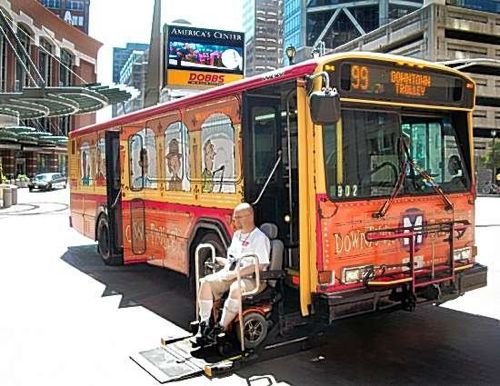
Another bus I used to ride often is the #99 downtown trolley, introduced in
Me exiting the Downtown Trolley on the day it debuted in July 2010. The bright wrap ceased being used a few years ago. Photo by Jim Merkel
Q: Agree or disagree: Metro’s new ‘Metro Reimagined’ with more frequent bus service will result in significant ridership increases.
Strongly agree: 0 [0%]
Agree: 2 [7.14%]
Somewhat agree: 4 [14.29%]
Neither agree or disagree: 3 [10.71%]
Somewhat disagree: 3 [10.71%]
Disagree: 5 [17.86%]
Strongly disagree: 9 [32.14%]
Unsure/No Answer: 2 [7.14%]
More than 60% didn’t think this will lead to a significant increase in ridership. That’s fair, I think the primary goal was to better serve existing riders — to stop losing ridership.
Riders in some parts of the county will see less service. My intention is for future posts to look at what’s working well, and what’s not.
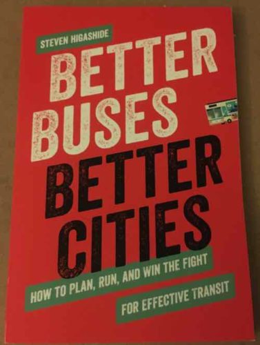
September 30, 2019Books, Featured, Public Transit, TransportationComments Off on New Book — ‘Better Buses, Better Cities: How to Plan, Run, and Win the Fight for Effective Transit’ by Steven Higashide
‘Better Buses, Better Cities: How to Plan, Run, and Win the Fight for Effective Transit’ by Steven Higashide will be available October 10, 2019.
I’ve known for a while that today’s the day Metro rolls out the biggest change to bus routes in decades. I wasn’t sure how I’d evaluate the changes then last week a new book shows up: ‘Better Buses, Better Cities: How to Plan, Run, and Win the Fight for Effective Transit’ by Steven Higashide.
Imagine a bus system that is fast, frequent, and reliable—what would that change about your city?
Buses can and should be the cornerstone of urban transportation. They offer affordable mobility and can connect citizens with every aspect of their lives. But in the US, they have long been an afterthought in budgeting and planning. With a compelling narrative and actionable steps, Better Buses, Better Cities inspires us to fix the bus.
Transit expert Steven Higashide shows us what a successful bus system looks like with real-world stories of reform—such as Houston redrawing its bus network overnight, Boston making room on its streets to put buses first, and Indianapolis winning better bus service on Election Day. Higashide shows how to marshal the public in support of better buses and how new technologies can keep buses on time and make complex transit systems understandable.
Higashide argues that better bus systems will create better cities for all citizens. The consequences of subpar transit service fall most heavily on vulnerable members of society. Transit systems should be planned to be inclusive and provide better service for all. These are difficult tasks that require institutional culture shifts; doing all of them requires resilient organizations and transformational leadership.
Better bus service is key to making our cities better for all citizens. Better Buses, Better Cities describes how decision-makers, philanthropists, activists, and public agency leaders can work together to make the bus a win in any city.
Though I have a hard time post-stroke reading a book cover to cover, I dived into the introduction and some chapters. Here are the contents so you can see how it’s organized:
Preface: My Own Bus Story
Acknowledgements
Introduction: We Need to Unleash the Bus
Chapter 1: What Makes People Choose the Bus?
Chapter 2: Make the Bus Frequent
Chapter 3: Make the Bus Fast and Reliable
Chapter 4: Make the Bus Walkable and Dignified
Chapter 5: Make the Bus Fair and Welcoming
Chapter 6: Gerrymandering the Bus
Chapter 7: Technology Won’t Kill the Bus—Unless We Let It
Chapter 8: Building a Transit Nation
Conclusion: Winning Mindsets and Growing Movements
The introduction agues we must reduce greenhouse emissions from transportation — public transit it how we accomplish that goal. Specifically, the bus is how we reduce greenhouse emissions by reducing car trips — including Lyft & Uber trips. Higashide also points out that civic leaders, business leaders, and transit agency executives & board members don’t ride the bus in their regions. Non-riders think adding wifi, for example, will make a difference. Frequency and convenience is what matters. If the bus runs every 15 minutes that’s great — bus not if you need to walk 5 blocks on each end of the trip.
If you’re interested in learning about the importance of bus service is to a region, and how to improve it, I suggest getting this book when it comes out October 10th. Read more about author Steven Higashide here.
I’ll be using this book as a guide for my first look at Metro’s new bus service on Wednesday morning.
Our elected officials like stop signs, from March 2017:
You can’t just erect a stop sign by fiat, not in St. Louis, as Alderman Cara Spencer has learned.
Spencer, 20th Ward, put up the stop sign Wednesday afternoon at Chippewa Street and Marine Avenue because she said it was a dangerous intersection near a school. The city’s Streets Department removed it Thursday.
Mayor’s office spokeswoman Maggie Crane said no actions were taken against Spencer because “we recognize that this was a publicity stunt.” Spencer said she had tried since September to get city officials to put one there, but didn’t receive an answer until January. The city told her there was not enough data to prove the intersection was dangerous or merited a stop sign, but recommended she introduce legislation to have one erected. Spencer said that process might have taken until May to get a stop sign posted. The Board of Aldermen began a spring recess in February and will not reconvene until April. (Post-Dispatch)
Legislation is how stop signs usually get installed. Yes, a bill is introduced. A committee hearing is held. A majority of the 28-member Board of Aldermen must approve, it’s then signed by the mayor — becoming an ordinance. Two such bills were introduced at their last meeting before summer break — see BB91 & BB92.
But what about the reverse, when an intersection is no longer an intersection?
Stop sign on 22nd Street where it used to intersect with Montgomery Street — vacated for the NGA West project, right
The intersection of 22nd Street and Montgomery Street no longer exists, but the stop signs on 22nd remain. In my mind these signs should’ve been removed when Montgomery Street was vacated, closed, or physically removed. Yet they remain.
While I’m here I wonder if the NGA, a high security government facility, will oppose on-street parking on the west side of 22nd Street. If so, it should be narrowed accordingly.
I’ll be contacting the city’s Citizen Service Bureau about this stop at an intersection that no longer exists.
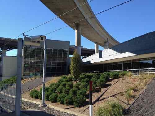
June 24, 2019Featured, TransportationComments Off on Noxious Weeds Outside St. Louis’ Gateway Transportation Center
The city-owned Gateway Transportation — home to Amtrak, Greyhound, and Megabus — has a landscaped area between it and the adjacent Civic Center MetroLink station. The landscaping has never been noteworthy. I was at the ribbon cutting in November 2008, but my exterior landscaping pics aren’t that old.
October 2011: non-planted sections with planted in betweenApril 2015, largely unchanged
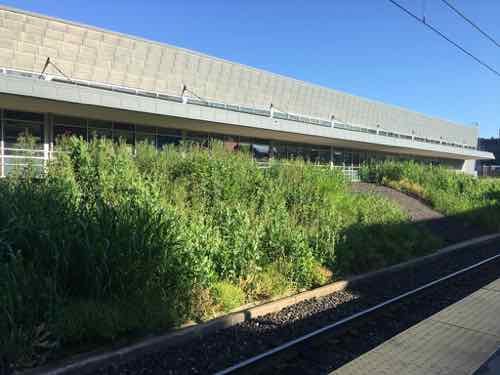
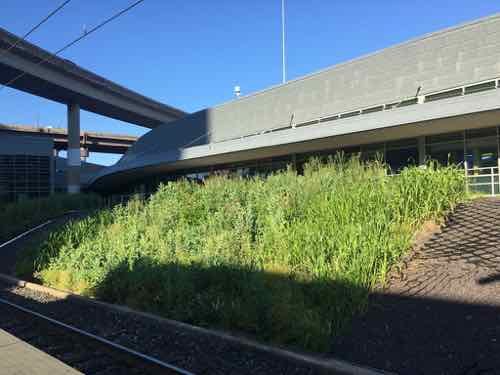
On the 7th of this month we were at the station early to catch our train to Chicago. I stopped to snap a pick of the…weeds.
Friday June 7th @ 6am, all the weeds were hard to miss.
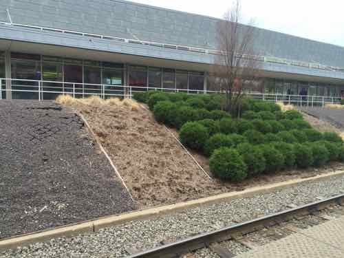
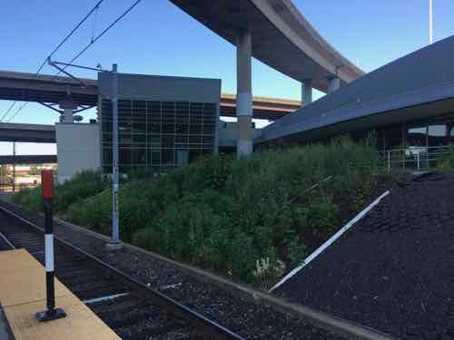
Less than a week later I came down to the area the morning after the Blues won the Stanley Cup. I was quiet at Enterprise, but I really noticed the weeds from the MetroLink platform.
June 13, 2019 @ 7:30amThe material to keep the gravel in the non-planted section from moving is now clearly visible
I sent these images to a landscape architect friend, she said it might have been intended as a native garden — but she sees “some thistles (noxious weed).” All landscaping requires regular weeding, something this hasn’t had.
The city issues citations to homeowners for less than this. If a homeowner had this as their yard the city would come mow it and send them a bill. This looks completely unkept, neglected.
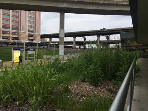
It would be nice to see more attention paid to this area since it’s in such a highly-visible location. I can only imagine what our guests from Boston must’ve thought.
I don’t know if this landscaping is the responsibility of the city’s comptroller, Metro, or some other entity. I’ll send this post around today and hopefully someone will step up and get the landscaping cleaned up. Or the city will ticket itself?
MetroLink will have extra trains ready to go on Saturday as hundreds of thousands of Blues fans head downtown to celebrate with the Stanley Cup Champions, the St. Louis Blues.
With five downtown MetroLink stations a block or two away from the Stanley Cup Parade, MetroLink is the perfect option while avoiding road construction, traffic and parking issues.
What about residents of North & South city that don’t yet have light rail?
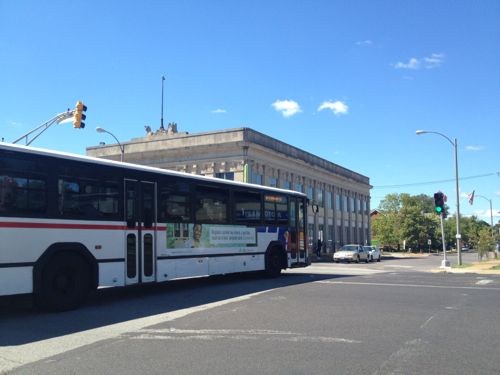
2012: The #11 MetroBus crosses Jefferson Ave. heading west on Chippewa Ave.
Yes, MetroBus is a good option. Since Metro’s marketing folks don’t seem to want to suggest their own service I decided to step up and show you some suggested routes. Those of us who live in the city are well-served by transit, if we take it downtown that’ll ease congestion for everyone downtown. We’re not all served by light rail.
My focus is on MetroBus routes that enter downtown, though other routes could connect you to say the Forest Park MetroLink station — the 90 Hampton MetroBus serves both North, West, & South city. Of course the busiest MetroBus route, the 70 Grand, is an excellent option to reach MetroLink.
Because the Civic Center Transit Center is on the south edge of downtown (Downtown West technically) the south routes have less disruption from downtown events. However, most should be good, assuming you get downtown prior to street closures.
From South City:
8 Bates-Morganford winds its way through the city on streets like: Loughborough, Holly Hills, Tower Grove, Shaw, Russell, 12th/Tucker, and — Bates & Morganford. On Saturday this bus runs every hour, the last bus before the parade arrives at Civic Center at 11:40am.
10 Gravois-Lindell originates at Gravois & Hampton, cutting a diagonal path through south city along Gravois. Saturday morning this bus runs every 30 minutes.
11 Chippewa runs every 40 minutes on Saturday morning, from the Shrewsbury MetroLink Station along Landsdowne, Chippewa, and Jefferson. Normally the EB bus heading into downtown goes up to Market but tomorrow it’ll use Chouteau to 14th to avoid the parade.
20 South Broadway serves South County & South City including South County Mall, Jefferson Barracks, far south city, & Soulard. On Saturday it runs every hour.
30 Arsenal is another route running through south city between Shrewsbury MetroLink and Civic Center Transit Center in Downtown West. It primarily uses Arsenal for the East-West portion and Broadway for the North-South. The 30 runs every 40 minutes on Saturdays.
31 Chouteau connects the Maplewood/Manchester MetroLink Station to Civic Center via Manchester in both the county & city, and Chouteau. It runs every hour on Saturdays.
73 Carondelet serves both south county & city, every 30 minutes on Saturdays. Streets include: Michigan, Virginia, Osceola, Meramec, Cherokee, Lemp, and Truman Parkway.
80 Park-Shaw connects the CWE MetroLink to Civic Center via south city. Similar to 8 above, but the route is different. Every hour on Saturdays.
From North City — most will have a reroute in the downtown area due to the parade.
4 Natural Bridge travels mostly along Natural Bridge, then using Parnell/Jefferson, usually to Market. Due to the parade it’ll reroute by staying on Jefferson to Chouteau to 14th to Civic Center. The 4 runs every 40 minutes on Saturdays.
19 St. Louis Ave connects the Rock Road MetroLink to Civic Center, through the heart of The Ville. It runs every 40 minutes on Saturdays. Because 14th will be closed for the parade it’ll reroute to Olive, Jefferson, Chouteau, 14th — if you take this bus to the parade I suggest exiting at 14th & Olive. The 19 runs every 40 minutes on Saturdays.
32 ML King also connects Rock Road to Civic Center, a little further south than the 19. It uses ML King & Cass for East-West and 9th/10th for North-South. At Washington & Tucker it will due a massive reroute along Washington to Jefferson, to Chouteau, to 14th. Avoid the reroute and exit before Tucker. The 32 runs every 40 minutes on Saturdays.
40 North Broadway connects Riverview to downtown, primarily along Broadway. Like the 32 it reroutes along Washington from Broadway to Jefferson — avoid all that and get off at Broadway & Washington! The 40 runs every hour on Saturdays.
41 Lee runs every 40 minutes between Riverview and downtown/Civic Center on streets like Thekla, Emerson, Lee, Kossuth, 20th, Carr. Like other bus routes, avoid the very long reroutes by exiting at 14th & Olive.
74 Florissant runs every half hour connecting north county to downtown via West/North Florissant. Like others, exit at 14th & Olive to avoid the long reroute.
From West City:
10 Gravois-Lindell was mentioned above on the South City section, but for those in midtown it’s a good option to get to Civic Center. It’ll reroute at Jefferson to Chouteau so either stay on the bus to Civic Center or exit at Olive & Jefferson and walk to the parade start at 18th & Market. Or take it WB to the CWE to catch the train downtown.
94 Page runs every 40 minutes on Saturdays connecting Westport Plaza via Wellston to Civic Center. In the city it primarily uses Page, 18th, Market. Because of the parade it’ll reroute at 18th & Olive to Jefferson, Chouteau. Either get off at 18th & Olive or continue to Civic Center.
96 Market Street Shuttle runs every hour on Saturdays. This is an option for SLU/Harris Stowe students. It’ll reroute at Jefferson to Chouteau.
97 Delmar connects Clayton to Civic Center via the Delmar/Loop MetroLink, running every 30 minutes on Saturdays. In the city it primarily uses Delmar, Compton (briefly) and Washington. Due to the parade it’ll reroute at Washington to Jefferson, to Chouteau.
The links above are to the regular map for each route, for a list of all MetroBus routes click here. Again, if you live in the city and plan to attend the parade please walk, bike, or use transit — bus and/or rail. The cash fare each way is $2 — have $1 bills because you can’t get change on the bus. If you need to take more than one bus or bus plus rail you’ll need $3 each way for a transfer. For exact times, stop locations, etc use Google Maps, Apple Maps, the Transit App, or Metro’s Trip Planner.
Street parking isn’t free on Saturday, and lots will be charging a lot. Uber/Lyft will likely have surge pricing, plus will have to deal with lots of traffic. Take transit — light rail or MetroBus.
AARP Livibility Index
The Livability Index scores neighborhoods and communities across the U.S. for the services and amenities that impact your life the most
Built St. Louis
historic architecture of St. Louis, Missouri – mourning the losses, celebrating the survivors.
Geo St. Louis
a guide to geospatial data about the City of St. Louis
 I sent these images to a landscape architect friend, she said it might have been intended as a native garden — but she sees “some thistles (noxious weed).” All landscaping requires regular weeding, something this hasn’t had.