Home » Public Transit » Recent Articles:

Cleveland’s Healthline Bus Rapid Transit (BRT), Part 2

Last week I introduced you to transit in Cleveland. including their Heathline Bus Rapid Transit (BRT), see Cleveland’s Healthline Bus Rapid Transit (BRT), Part 1. In summary, they had long planned street-running light rail (LRT) on their most important East-West corridor — Euclid Avenue.

RTA originally conceived the project in the 1980s as the “Dual Hub” light-rail line, but found in the 1990s that a rail line would have cost $700 million to $800 million. Inspired by the rapid bus system in Curitiba, Brazil, RTA redesigned the Euclid Avenue project to achieve the speed and high-class feel of light rail at the lower cost of a bus line. (Euclid Corridor Health Line is a strong RX for Cleveland’s once and future Main Street)

Curitiba, Brazil? In 1971 a young architect. Jaime Lerner, became mayor.

Realising the importance of mass transit, planners called for the creation of subway lines, as well as widened streets for cars – but construction would be costly and could take decades to complete.

Instead, Lerner saw an opportunity in the one form of transport that many considered a lost cause: the bus. His idea was to devise a system that gave buses as many of the functional advantages of urban train systems as possible. He proposed to integrate dedicated bus lanes along the city’s main arteries, with stations placed on medians along the routes. This would allow buses to run at speeds comparable to light rail, while dramatically reducing the cost. 

A savvy deal-maker, Lerner made a bargain with private bus operators to pay for the creation of the new infrastructure, while they would provide the vehicles in exchange. With this trade-off in place, the first rapid bus lanes of Curitiba ended up costing 50 times less than rail.

Though the system wasn’t an instant success after the opening of the first line in 1974, it gradually worked its way into the livelihoods of residents. In 1979, Lerner created the Rede Integrada de Transporte (Integrated Transport Network) to better manage the system and, as new routes were added, it began to show its full potential. By 1993, it was carrying 1.5 million passengers a day.

But high ridership created a problem. Buses in the system still used conventional boarding systems, where passengers entered through the front of the bus and paid fares on board. Lerner, who was back in office for his third term as mayor, came up with an elegant solution.

He called for a revamped station design that enabled faster boarding through multiple doors, and fares would be exchanged before entering the station – similar to subway or light-rail systems. Offboard payment would also allow for the creation of transfer stations, meaning one fare would cover the entire system. To top it off, Lerner gave the stations a distinctive look by placing them in futuristic glass tubes. These new “tube stations” debuted in October 1991 as part of the first Ligeirinho express line. Today there are 357 tube stations throughout the city. (How Curitiba’s BRT stations sparked a transport revolution)

Curitiba’s Rede Integrada de Transporte has been so successful (overcrowded) they are now considering a costly subway system. This new mode, BRT, prompted Cleveland transportation planners to switch from LRT to BRT in planning for their Euclid Ave. corridor.

bbb
bbb

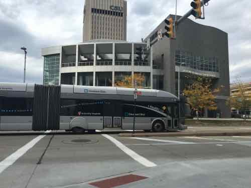
It has paid off handsomely — Cleveland’s Heathline is the highest ranked BRT in the U.S. However, it isn’t ranked high enough to achieve a gold-level rating. In 2014 it got a score of 76/100 — giving it a silver rating.  No BRT system in the world has earned the full 100 points, Curitiba’s Green Line ranks second worldwide with a 92/100 score. The highest ranking BRT is in Guadalajara, Mexico with 93/100. Here are some videos on BRT in Guadalajara (Spanish but the visuals are great) & Curitiba.

Let’s take a closer look at the 14 areas where Cleveland’s Healthline missed 24 points:

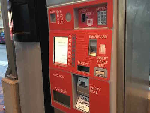
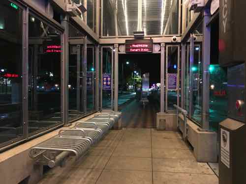
Off-board fare collection 6/7

Off-board fare collection is one the most important factors in reducing travel time and improving the customer experience. There are presently two basic approaches to off-board fare collection: “Turnstile-controlled,” where passengers pass through a gate, turnstile, or checkpoint upon entering the station where their ticket is verified or fare is deducted, and “proof-of-payment,” where passengers pay at a kiosk and collect a paper ticket that is then checked on board the vehicle by an inspector. Both approaches can significantly reduce delay. Turnstile-controlled is slightly preferred, but proof-of-payment systems on bus routes that extend beyond BRT corridors extend the benefits of time savings to those sections of the bus routes that lie beyond the BRT corridor.

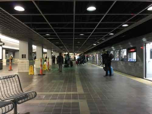
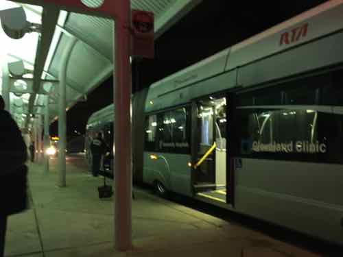
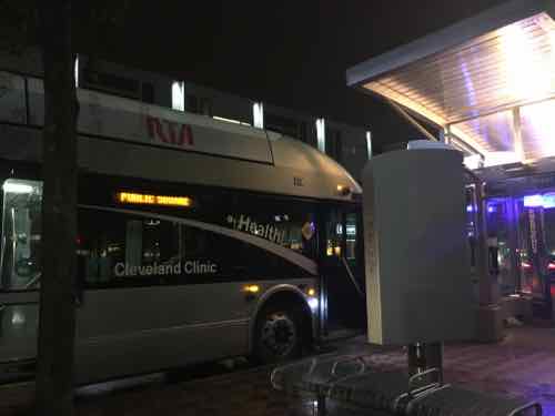
Each station along Cleveland’s Healthline has a fare machine where tickets can be purchased — we mostly opted for day passes because they’re priced at just $5, a roundtrip would be $4.50. Our Metro doesn’t offer day passes.

Off-board fare machine located within each station.
Signs in each station indicating fare must be paid, if checked. This is likely why a point was lost.

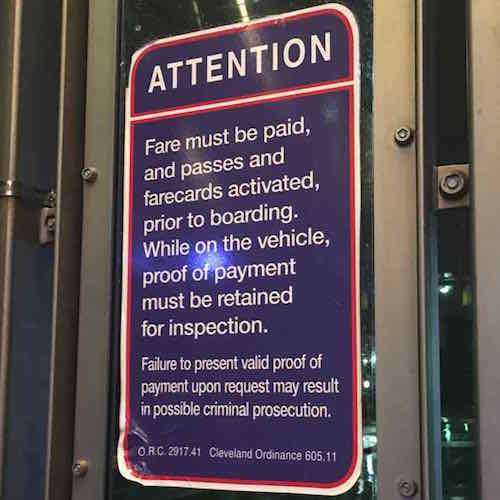
At times I rode the Healthline boarding passengers would enter through the numerous side doors and walk to the front to swipe their cards on the fare box by the driver. Other times my husband tried to swipe his card and the driver said they weren’t worrying about fare collection at that time. I still don’t when a person is expected to go all the way up to the front of the bus to swipe their payment — at least the bus was able to keep moving during the fare parade.

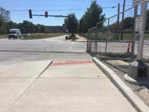
Intersection Treatments 3/6

There are several ways to increase bus speeds at intersections, all of which are aimed at increasing the green-signal time for the bus lane. Forbidding turns across the bus lane and minimizing the number of traffic-signal phases where possible are the most important. Traffic-signal priority, when activated by an approaching BRT vehicle, is useful in lower-frequency systems but less effective than turn prohibitions.

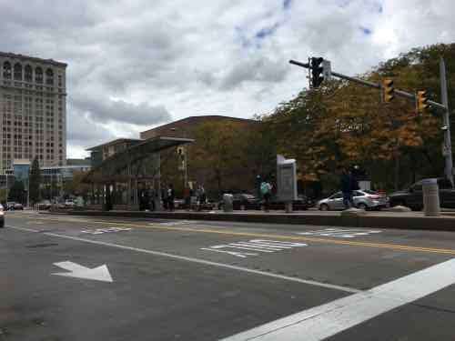
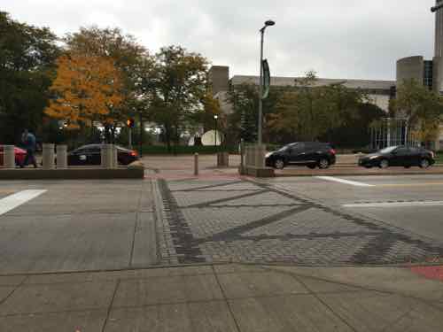
Cleveland allows left turns across the bus-only lane, on left arrow.

The car & truck are in a left turn lane. To their right is a lane for vehicles continuing Eastbound on Euclid Ave., to their left is a bus-only lane.

I’m curious how cities handle traffic where left turns aren’t allowed across the bus lane. A prohibition on left turns is very much like street-running light rail.
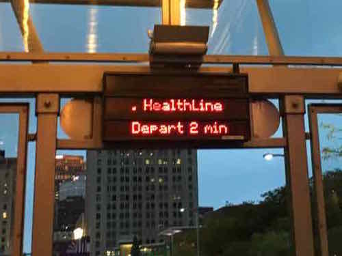
Peak frequency 1/3

How often the bus comes during peak travel times such as rush hour is a good proxy for quality of service. For BRT to be truly competitive with alternative modes, like the private automobile, passengers need to be confident that their wait times will be short and the next bus will arrive soon.

During peak times it is every 5 minutes, which means morning & afternoon weekday rush:

Arriving every 5 minutes during morning and afternoon weekday rush hours, and providing service in 10, 15, 20 and 30 minute increments during other hours, the HealthLine offers service 24 hours a day, 7 days a week.

Often when we'd arrive at a station the sign
Displays in each station indicated how many minutes until the next departure. I didn’t see this for their regular bus service though common in Chicago.

Off-peak frequency 0/2

As with peak frequency, how often the bus comes during off-peak travel times is a good proxy for quality of service.

The RTA website says during off-peal it operates every 8-15 minutes, but as the quote above indicates, it is actually 10-30 minutes off-peak.

At 2:41am I had a 30-minute layover on the East end of the Healthline

I was impressed the Healthline operates 24/7.

Express, Limited, and Local Services 0/3

One of the most important ways that mass-transit systems increase operating speeds and reduce passenger travel times is by providing limited and express services. While local services stop at every station, limited services skip lower-demand stations and stop only at major stations that have higher passenger demand. Express services often collect passengers at stops at one end of the corridor, travel along much of the corridor without stopping, and drop passengers off at the other end.

Infrastructure necessary for the inclusion of express, limited, and local BRT services is captured in other scoring metrics.

Cleveland didn’t design their system for Express or Limited service. Like regular bus routes, it doesn’t stop at a station unless someone wants to board or de-board. Still it can take a while to travel from end to end.

Multi-corridor network 1/2

Ideally, BRT should include multiple corridors that intersect and form a network, as this expands travel options for passengers and makes the system more viable as a whole. When designing a new system, some anticipation of future corridors is useful to ensure the designs will be compatible with later developments. For this reason, a long-term plan is recognized, with an emphasis on near-term connectivity through either BRT services or infrastructure.

Not sure why they received 1/2 points.

Passing lanes at stations 2/4

Passing lanes at station stops are critical to allow both express and local services. They also allow stations to accommodate a high volume of buses without getting congested with buses backed up waiting to enter. While more difficult to justify in low-demand systems, passing lanes are a good investment, yielding considerable passenger travel-time savings and allowing for flexibility as the system grows.

Again, they didn’t plan for Express & Limited — but they do have some points where one bus can pass by another,

Minimizing bus emissions 2/3

Bus tailpipe emissions are typically a large source of urban air pollution. Especially at risk are bus passengers and people living or working near roadsides. In general, the pollutant emissions of highest concern from urban buses are particulate matter (PM) and nitrogen oxides (NOx). Minimizing these emissions is critical to the health of both passengers and the general urban population.

The primary determinant of tailpipe emission levels is the stringency of governments’ emissions standards. While some fuels, like natural gas, tend to produce lower emissions, new emission controls have enabled even diesel buses to meet extremely clean standards. However, “clean” fuels do not guarantee low emissions of all pollutants. As a result, our scoring is based on certified emissions standards rather than fuel type.

Over the last two decades, the European Union and the United States have adopted a series of progressively tighter emissions standards that are being used for this scoring system. Buses must be in compliance with Euro VI and U.S. 2010 emission standards to receive 3 points. These standards result in extremely low emissions of both PM and NOx. For diesel vehicles, these standards require the use of PM traps, ultra-low-sulfur diesel fuel, and selective catalytic reduction. To receive two points, buses need to be certified to Euro IV or V with PM traps (note: 50 ppm sulfur diesel fuel or lower is required for PM traps to function effectively).

Vehicles certified to the Euro IV and V standards that do not require traps emit twice as much PM as vehicles meeting more recent standards. Therefore, these vehicles are awarded one point. Ideally, buses will include contractually stipulated requirements in the purchase order to control real-world NOx emissions from buses in use, because the actual NOx emissions from urban buses certified to Euro IV and V have been tested at levels substantially higher than certified levels. Because that is hard to verify, it is included as a recommendation, but not as a requirement, for receiving the one point. Zero points are awarded for U.S. 2004 and Euro III standards and less stringent standards, because these standards allow ten times as much PM emissions as the U.S. 2010 and Euro VI standards.

Buses also generate greenhouse gas emissions. Since no clear regulatory framework exists that requires bus manufacturers to meet specific greenhouse-gas emission targets or fuel-efficiency standards, there is no obvious way to identify a fuel-efficient bus by vehicle type. For CO2 impacts, we recommend the use of the TEEMP model, which incorporates the BRT Standard into a broader assessment of project-specific CO2 impacts.

Emissions is one area where rail (streetcars, light rail) is superior to diesel busses.

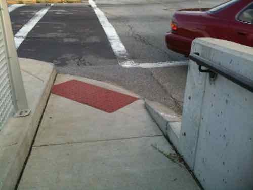
Stations set back from intersections 1/3

Stations should be located at minimum 26 meters (85 feet), but ideally 40 meters (130 feet), from intersections to avoid delays. When stations are located just beyond the intersection, delays can be caused when passengers take a long time to board or alight and the docked bus blocks others from pulling through the intersection. If stations are located just before an intersection, the traffic signal can delay buses from moving from the station and thus not allow other buses to pull in. The risk of conflict remains acute, particularly as frequency increases. Separating the stations from the intersections is critical to mitigating these problems.

Cleveland’s Healthline has a variety of station types, but most are near intersections.

This station serves Westbound bus heading downtown, it allows the bus to get out of the intersection for boarding.
One station was entered via a mid-block walkway.

Center stations 1/2

Having a single station serving both directions of the BRT system makes transfers between the two directions easier and more convenient—something that becomes more important as the BRT network expands. It also tends to reduce construction costs and minimize the necessary right-of-way. In some cases, stations may be centrally aligned but split into two—called split stations, with each station housing a particular direction of the BRT system. If a physical connection between the two directions is not provided, fewer points are awarded. Bi-lateral stations (those that, while in the central verge, are curb-aligned) get no points.

The stations on the East end aren't in the center
The stations on the East end aren’t in the center

The stations on the East end aren’t in the center.

Sliding doors in BRT stations 0/1

Sliding doors where passengers get on and off the buses inside the stations improve the quality of the station environment, reduce the risk of accidents, protect passengers from the weather, and prevent pedestrians from entering the station in unauthorized locations.

The small stations are open on both ends, an opening on one or both sides for the bus. The other bus doors open onto platform, not in the shelter.

Integration with other public transport 1/3

When a BRT system is built in a city, a functioning public transport network often already exists, be it rail, bus, or minibus. The BRT system should integrate into the rest of the public transport network. There are two components to BRT integration:

  • Physical transfer points: Physical transfer points should minimize walking between modes, be well-sized, and not require passengers to exit one system and enter another;
  • Fare payment: The fare system should be integrated so that one fare card may be used for all modes.

Very little observed integration.

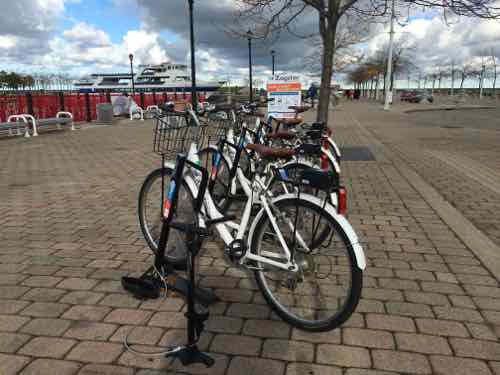
Secure bicycle parking 1/2

The provision of bicycle parking at stations is necessary for passengers who wish to use bicycles as feeders to the BRT system. Formal bicycle parking facilities that are secure (either monitored by an attendant or observed by security camera) and weather-protected are more likely to be used by passengers.

Didn’t see any bike parking.

Bicycle lanes 1/2

Bicycle-lane networks integrated with the BRT corridor improve customer access, provide a full set of sustainable travel options, and enhance road safety.

Bicycle lanes should ideally connect major residential areas, commercial centers, schools, and business centers to nearby BRT stations to provide the widest access. All such major destinations within at least two kilometers of a corridor should be connected by a formal cycleway.

Moreover, in most cities, the best BRT corridors are also the most desirable bicycle routes, as they are often the routes with the greatest travel demand. Yet there is a shortage of safe cycling infrastructure on those same corridors. If some accommodation for cyclists is not made, it is possible that cyclists may use the busway. If the busway has not been designed for dual bike and bus use, it is a safety risk for cyclists. Bicycle lanes should be built either within the same corridor or on a nearby parallel street and should be at least 2 meters, for each direction, of unimpeded width.

Didn’t see any bike lanes.

Bicycle-sharing integration 0/1

Having the option to make short trips from the BRT corridor by a shared bicycle is important to providing connectivity to some destinations. Operating costs of providing bus service to the last mile (i.e., feeder buses) are often the highest cost of maintaining a BRT network; thus, providing a low-cost bicycle-sharing alternative to feeders is generally seen as best practice.

Only saw one bike-share area during our visit, not close to the Healthline.
Only saw one bike-share area during our visit, not close to the Healthline. 

Still seeking donations toward the cost of the trip — have raised $200 of the $375 total so far — click here to donate $5, $10, $15 or more.

Next week Part 3 will look at areas of the Healthline’s design & operation I didn’t like.

— Steve Patterson


Cleveland’s Healthline Bus Rapid Transit (BRT), Part 1

October 26, 2015 Featured, Planning & Design, Public Transit, Transportation, Travel Comments Off on Cleveland’s Healthline Bus Rapid Transit (BRT), Part 1

I’m back from my brief Bus Rapid Transit (BRT) research trip in Cleveland. I’m still processing the experience so today I want to introduce their transit system, the Healthline BRT in particular.

BRT is an innovative, high capacity, lower cost public transit solution that can significantly improve urban mobility. This permanent, integrated system uses buses or specialized vehicles on roadways or dedicated lanes to quickly and efficiently transport passengers to their destinations, while offering the flexibility to meet transit demand. BRT systems can easily be customized to community needs and incorporate state-of-the-art, low-cost technologies that result in more passengers and less congestion. (National BRT Institute)

In short, BRT is an alternative to light rail/streetcar systems.

The HealthLine route travels 6.8 miles (11 km) along Euclid Avenue from Public Square in Downtown Cleveland to Louis Stokes Station at Windermere in East Cleveland. It passes through the neighborhoods of Downtown, Midtown, Fairfax, University Circle and the suburb of East Cleveland.

Between Public Square and East 105th Street, Euclid Avenue has two “bus only” lanes close to the inner median which only allow HealthLine vehicles passage, reducing delays due to conflicts with general traffic during busy times. Complementing the HealthLine is a set of bike lanes on the outer edges of the stretch Euclid Avenue that connects Cleveland State University with Case Western Reserve University. (Wikipedia)

It should be noted they don’t have a newer light rail system like our MetroLink, their rail lines all date from the early to mid-20th century. Two 1913 suburban streetcar lines are now considered light rail, Blue & Green. Their main rail line, Red, is a heavy rail line. Planned before 1930, it didn’t open until 1955. The last extension, to their airport, was in 1968. Red, Blue, & Green share some track & stations. All three stop at Tower City-Public Square, an underground station connected to the 1930 Terminal Tower.

Built for $179 million by the Van Sweringen brothers, the tower was to serve as an office building atop the city’s new rail station, the Cleveland Union Terminal. Originally planned to be 14 stories, the structure was expanded to 52 floors with a height of 708 feet (216 m). It rests on 280-foot (85 m) caissons. Designed by the firm of Graham, Anderson, Probst & White, the tower was modeled after the Beaux-Arts New York Municipal Building by McKim, Mead, and White. The Terminal Tower opened for tenants in 1928, though the Union Terminal complex wasn’t dedicated until 1930.

It remained the tallest building in the world outside of New York City until the completion of the main building of Moscow State University in Moscow in 1953; it was the tallest building in North America outside of New York until the Prudential Center in Boston, Massachusetts, was completed in 1964. (Wikipedia)

Let’s state a look.

The platform at Tower City-Public Square. Their interurban streetcar lines converged at this downtown location.
Looking from the mall inside Tower City down to the transit level.
The grand lobby of Tower Terminal leading out to Public Square
Public Square is being rebuilt in time for the 2016 GOP convention, Tower Terminal is in the background.

During construction the cross streets, Ontario & Superior, are blocked off:

Public Square is the four-block central plaza of downtown Cleveland, Ohio. Based on an 18th-century New England model, it was part of the original 1796 town plat overseen by Moses Cleaveland, and remains today as an integral part of the city’s center. The 10-acre (4.0 ha) square is centered on the intersection of Superior Avenue and Ontario Street. Cleveland’s three tallest buildings, Key Tower, 200 Public Square and the Terminal Tower, face the square. Other Public Square landmarks include the 1855 Old Stone Church and the former Higbee’s department store made famous in the 1983 film A Christmas Story. It reopened as the Horseshoe Casino Cleveland on May 14, 2012.

A 125-foot monument to Civil War soldiers and sailors occupies the southeast quadrant of the square. City founder Moses Cleaveland and reformist mayor Tom L. Johnson each have statues on the square. (Wikipedia)

It appears Ontario will remain closed, with Superior reopening in 2016 — the four distinctive blocks will become two rectilinear blocks visually connected on other side of Superior. For more information click here.

Why have I spent so much time leading up to Public Square? Because prominent corridor, Euclid Avenue, traveling from Public Square out to the adjacent suburb of East Cleveland. Euclid Ave is Cleveland’s Main Street.

St. Louis has no equivalent. Broadway travels North & South from our downtown out into the suburbs, but it doesn’t have major institutions. Extending West from downtown Olive/Lindell has many institutions and population density, but it doesn’t even reach the city limits.

For decades Cleveland’s Euclid corridor was served by bus, the No. 6.  Like our #70 MetroBus route on Grand, their No. 6  was heavily used. Like our long-diuscuyssed North-South MetroLink, their original plan was for street-running light rail.

RTA originally conceived the project in the 1980s as the “Dual Hub” light-rail line, but found in the 1990s that a rail line would have cost $700 million to $800 million. Inspired by the rapid bus system in Curitiba, Brazil, RTA redesigned the Euclid Avenue project to achieve the speed and high-class feel of light rail at the lower cost of a bus line. (Euclid Corridor Health Line is a strong RX for Cleveland’s once and future Main Street)

From the same November 2008 article:

Critics complained about the two years of surgery on the avenue, which disrupted traffic and killed some small businesses. The work, however, was absolutely necessary; it replaced water and sewer lines that dated as far back as the turn of the 20th century. 

Critics also called the Health Line a boondoggle, saying it will do little more than provide a marginal improvement over the former No. 6 bus line, which was already the city’s most successful and heavily used route. The new line will cover the distance between downtown and University Circle in 20 minutes, 10 minutes less than the old line. 

It’s true that when measured purely in cost efficiency per rider, the project didn’t score high on tests required by the Federal Transit Administration as a condition for funding. But the project did meet those basic requirements.  (Euclid Corridor Health Line is a strong RX for Cleveland’s once and future Main Street)

A year later, during the worst of the recession, there were positive signs:

Despite the challenging financial climate, the $197 million renovation of Euclid Avenue has become an economic development engine for the city. More than $3.3 billion worth of projects are in the works or recently finished along five miles of the vital artery. 

To be sure, the progress has been slower than many would like. The number of projects would be far greater if not for an economic crisis that has stalled or killed developments across the country. And given a shortage of private lending, many of the high-profile projects along the corridor depend on institutions, tax credits and other incentives.

Nevertheless, builders are staring down the shaky real estate market and finishing town houses in University Circle. They’re completing apartments in former department stores downtown. And they’re pitching plans to make Midtown a biomedical and technology hub. (Cleveland’s Euclid corridor project has paved the way to economic development)

Going from the Megabus stop to our hotel we first spotted the Healthline, at E. 21st & Euclid Ave.

The Heathline is traveling Eastbound in its bus-only lane. The Cleveland State University Student Center in the background was built after the BRT line opened.

As I rode the Healthline I kept thinking much of the new development on hospital & university campuses would’ve happened anyway, but a good point was made in the 2009 article quoted above:

Without the corridor project, the university’s new buildings probably would have turned their backs to Euclid Avenue, creating a more insular campus. But the remade road has encouraged CSU to put its front doors on Euclid, to build on both sides of the street and to consider how the appearance of new university buildings fits with the avenue. (Cleveland’s Euclid corridor project has paved the way to economic development)

And therein lies a difference the BRT made versus a standard bus line — new buildings were built oriented toward the public street rather than internally.

Next week, in Part 2, we’ll take a closer look at specifics of the Healthline, list pros & cons, and discuss lessons for St. Louis.

— Steve Patterson


Bus Rapid Transit Research Trip, Funding Assistance Still Needed

Later this week I’ll arrive in Cleveland — my first time in that city — I think. My 2006 bus trip to Toronto may have routed through Cleveland. I do know I’ve never explored the city.  My purpose for visiting it to ride their Bus Rapid Transit (BRT) lines — the HealthLine and 55-A-B-C: Cleveland State Line. We’ll spend just over 48 hours in Cleveland, our hotel is located on the HealthLine.

Cleveland has many similarities to St. Louis — such as losing more than half its peak 1950 population.  Pollution was a problem, in 1969 the Cuyahoga River caught on fire! Earlier this year, Cleveland police agreed to train officers to minimize racial bias and the use of excessive force.

A few months ago I started a GoFundMe page to raise money for this 2-day research trip to Cleveland. So far I’ve raised $200 of the $375 needed — a little more than half.

Click image to open GoFundMe page

The rest of our vacation will be spent in Chicago.  There I’ll check out construction on Chicago’s first BRT line — the Loop Link:

Traffic-clogging construction has been underway for almost six months on Loop Link, the Emanuel administration’s experiment intended to speed CTA buses through downtown, yet the bus rapid transit service will be launched late this year with fewer features than originally promised, officials told the Tribune.

Even before the changes that threaten to reduce the benefits of the whole endeavor to ease congestion in the central Loop, the $32 million project was labeled “BRT Lite” by some transportation experts because its design lacked several elements that are key to helping buses replicate the service reliability of rail rapid transit. Those experts said making a strong first impression was vital to winning public backing for introducing bus rapid transit citywide. (Chicago Tribune – CTA bus rapid transit service to debut with fewer bells and whistles)

Cleveland’s HealthLine was given a 76/100 score by the Institute for Transportation & Policy Development — a Silver rating — the highest score of all BRT lines in the U.S. Other countries have higher ranked BRT systems:

Of the systems scored, 15 are classified as gold, 28 as silver, 41 as bronze, and 6 as “basic” BRT, indicating a minimum of BRT features, but not quite qualifying as best practice. Eight did not qualify as BRT. Furthermore, ITDP has identified 200 additional corridors that preliminarily meet the BRT basics.

The BRT Standard is an evaluation tool for world-class bus rapid transit based on international best practices. It is also the centerpiece of a global effort by leaders in bus rapid transit design to establish a common definition of BRT and ensure that BRT systems more uniformly deliver world-class passenger experiences, significant economic benefits, and positive environmental impacts. (ITDP)

Scores of other BRT lines in the U.S.

Bronze

  • Los Angeles CA (Orange line) 65/100
  • San Bernardino CA (E-Street) 63/100
  • Pittsburgh PA (MLK) 56/100
  • Seattle WA (SODO) 56/100
  • Eugene OR (Green line) 55/100

Basic

  • Pittsburgh PA (West) 51/100
  • Pittsburgh PA (South) 50/100

So we have no “Gold” BRT lines, and only one “Silver”.  See the scoring criteria here, of interest to me is station spacing:

In a consistently built-up area, the distance between station stops optimizes at around 450 meters (1,476 ft.). Beyond this, more time is imposed on customers walking to stations than is saved by higher bus speeds. Below this distance, bus speeds will be reduced by more than the time saved with shorter walking distances. Thus, in keeping reasonably consistent with optimal station spacing, average distance between stations should not be below 0.3 km (0.2 mi.) or exceed 0.8 km (0.5 mi.).

Two-tenths to a half mile spacing sounds like excellent criteria to me, Cleveland’s HealthLine did this. It also got all three points for Pedestrian Access:

A BRT system could be extremely well-designed and functioning but if passengers cannot access it safely, it cannot achieve its goals. Good pedestrian access is imperative in BRT system design. Additionally, as a new BRT system is a good opportunity for street and public-space redesign, existing pedestrian environments along the corridor should be improved.

Regular posts will continue here during my vacation/research trip, plus I’ll be posting images from Cleveland & Chicago to Twitter & Facebook. Would love to raise the remaining $175 before the credit card bill arrives.

— Steve Patterson


Don’t Wait For New Light Rail Station, Take MetroBus To IKEA

While I’ve ridden many MetroBus routes in the region, one I don’t recall is the #42 (Sarah). However, I’m familiar with it because other routes I ride, like the #10 (Gravois-Lindell), intersect with it. With the opening of the new IKEA St, Louis I noticed the #42 route makes a loop East past Sarah to Vandeventer. A new bus stop got my attention.

Nw bus stop right in front of IKEA
New bus stop right in front of IKEA

I always assumed it went North/South on Sarah, connecting with the Central West End MetroBus/MetroLink station via Forest Park. It does — but rather than turning there it uses Laclede to go East one block to Vandeventer.

If you use public transit in St. Louis you can easily get to IKEA. I use the #10 and just go down Vandeventer or Sarah from Lindell, but I could transfer to the #42 at Lindell & Sarah. Another option is the #32 from Manchester/Chouteau & Vandeventer. Many other MetroBus lines meet up with the #42 at the Central West End MetroLink light rail station.

I especially encourage the proponents of the North-South light rail to use this as an opportunity to actually familiarize themselves with MetroBus. The humble bus carries more people more places daily.

— Steve Patterson


Ramps To Cross Forest Park Parkway at DeBaliviere Greatly Improved

I often post about accessibility problems, but today’s post is about a problem that’s finally getting addressed. The reconstruction of the DeBaliviere viaduct/bridge over MetroLink tracks is making great improvements to crossing Forest Park  Parkway (map).  Tuesday I saw the improvement on the newly-opened West side.

The ramps on each side heading South weren't the best, the crosswalk was pushed out right next to traffic.
Before: The ramps on each side heading South weren’t the best, the crosswalk was pushed out right next to traffic. September 2010
Before: we had to use a narrow ramp reach the crosswalks. If you're waiting to cross a street someone crossing the other would be blocked.
Before: we had to use a narrow ramp reach the crosswalks. If you’re waiting to cross a street someone crossing the other would be blocked. These were also trip hazards to others. September 2010
After: Now the ramp is wide and directional. The crosswalk won't be up against Southbound traffic anymore.
After: Now the ramp is wide and directional. The crosswalk won’t be up against Southbound traffic anymore.
After: Looking back North you can see the West side isn't totally finished.
After: Looking back North you can see the West side isn’t totally finished.

After the East side and the crosswalks are complete I’ll do another post. I’m just so thrilled at the ramp improvement!

Hopefully the pedestrian signal buttons, once activated, will be solely for the visually impaired to get audio signals about when to cross. Other pedestrians shouldn’t need to press a button to get a walk signal.

— Steve Patterson


Advertisement


[custom-facebook-feed]

Archives

Categories

Advertisement


Subscribe