Home » Walkability » Recent Articles:

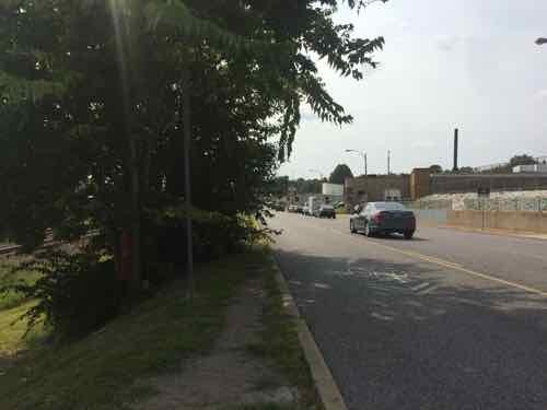
Lemay Ferry (MO-267) Is A Pedestrian Nightmare

Yesterday I posted about the horrible pedestrian environment along the #12 MetroBus route in St. Clair County. I took that bus on Wednesday the 16th. That night, Fox2 ran a related story (Disabled man hit 3 times on Lemay Ferry, due to lack of sidewalks):

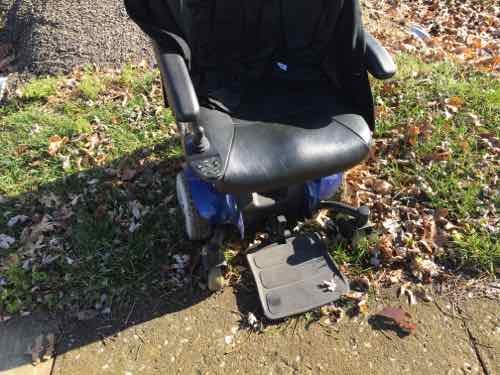
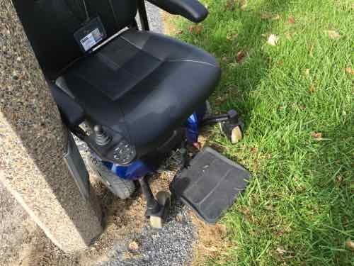
Tony Berding says he’s been hit 3 times by vehicles on Lemay Ferry.  Berding is disabled, and lives in a senior apartment complex in the 3600 block Lemay Ferry Road in South St. Louis County.  He uses a motorized wheelchair to travel to a nearby Quick Trip and Kmart.

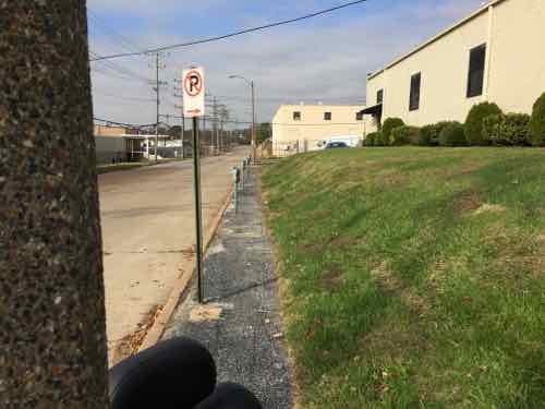
Berding was struck last Thursday while traveling on a narrow shoulder along northbound Lemay Ferry.

That evening a reader messaged me about the story, but I didn’t have time to watch. The next morning I got a message from Berding’s sister, so I watched — horrified watching her brother use the narrow shoulder to get to the store. We messaged via Facebook, then text, and finally on the phone. This is about real people at risk because of how we have chosen to build our physical environment.

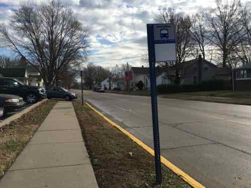
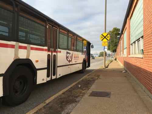
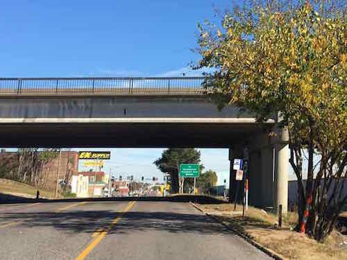
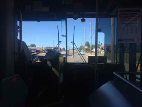
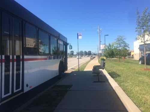
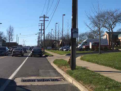
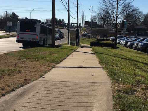
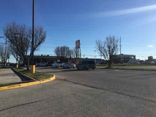
Lemay Ferry in South St. Louis County is far more urban than the area I traveled through in St. Clair County, I’ve taken the #73 MetroBus numerous times, most recently the morning of August 25, 2015:

A passenger got on at the SB stop across from Dierbergs
I took a pic of a vintage convertible in front of the QT mentioned in the Fox2 story
I got off past Lindbergh, I met my husband for lunch at IHOP

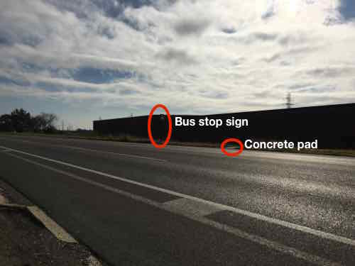
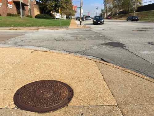
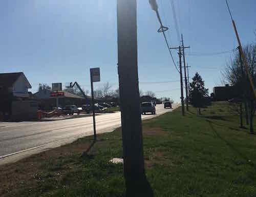
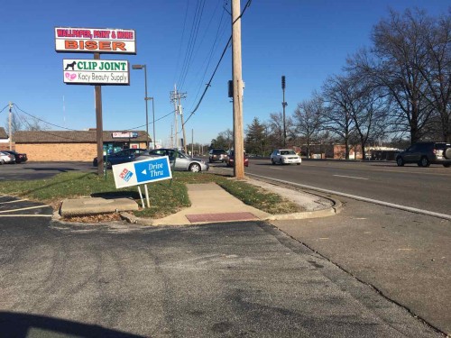
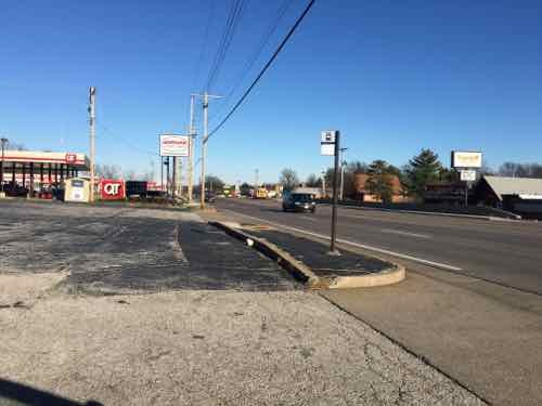
What I hadn’t done is roll along the part of Lemay Ferry mention in the Fox2 story. After looking at it on Google Street View I saw just how physically impossible the West side of Lemay Ferry was, the East side isn’t great — but it’s passable. I decided I’d have to drive to photograph. Before doing so I did some research.

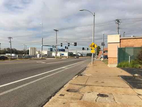
Fox2 said St. Louis County indicated they couldn’t afford to buy land for the right-of-way to build a sidewalk on the East side. Two problems here: Lemay Ferry is also known as MO-267 — it’s maintained by MoDOT, not the county.  Secondly, the right-of-way is 80 feet wide — more than enough width for four travel lanes, a center turn lane, and sidewalks on each side! More on this later, let’s take a look at the problem.

Not far into the County there are good sidewalks, but no pads for accessing the bus or routes to buildings set back behind parking.
There are spots on both sides where there is no pretense of a sidewalk, such as this cemetery stop
Even spots where sidewalks exist they don't always connect to buds stops/ The curb here makes this inaccessible.
Even spots where sidewalks exist they don’t always connect to buds stops/ The curb here makes this inaccessible.
Here's a spot where a wheelchair user has no choice but to use the shoulder. What about an able-bodied parent walking with a small child or pushing a stroller?
Here’s a spot where a wheelchair user has no choice but to use the shoulder. What about an able-bodied parent walking with a small child or pushing a stroller?
Just before Reevis Barracks the sidewalk & bus stop are excellent
I was delighted to see a good connection to the adjacent bank!
But pulling back out to Lemay Ferry I noticed the curb to the North
Many spots where you see a sidewalk on the West side they're located on private property, don't connect to adjacent property -- the drive where the car is exiting has a curb.
Many spots where you see a sidewalk on the West side they’re located on private property, don’t connect to adjacent property — the drive where the car is exiting has a curb.
Looking South we have the same situation. A private sidewalk not usable by those who need it. Decoration adding to water runoff issues.
We stopped to fill up the tank at the QT mentioned in the Fox2 story. For many convenience stores are their primary grocery store.
Looking back North you can see what appears to be a sidewalk -- but it isn't accessible. It is, however, located in the PROW.
Looking back North you can see what appears to be a sidewalk — but it isn’t accessible. It is, however, located in the PROW.
How does a pedestrian get to the QT from the sidewalk? Up these steps from the side street!
From the next property to the South we see how the shoulder is the only option for anyone in a wheelchair.
A little further South we see a bus stop sign on a curbed island -- located in the PROW.
A little further South we see a bus stop sign on a curbed island — located in the PROW.
Looking South toward the apartments where Tony Berding has lived since 2001
From the entrance drive looking back North. The QT is less than a 10th of a mile. Click image for map
The Kmart is to the South
Pretty much the same thing heading South to Kmart. Curb after curb...
Pretty much the same thing heading South to Kmart. Curb after curb…
At the Kmart parking lot you see the only way in is the auto driveway

So why not just move? When you’re disabled and low-income housing options are very limited.  It has been 25 years since the Americans with Disabilities Act became law — St. Louis County & the Missouri Dept of Transportation need to prioritize this.

Below are two examples of dividing the existing 80′ right-of-way so still have four drives lanes & a center turn lane.

Two scenarios for the 80' right-of-way. The top version has the overly wide lanes currently in use and the lower has better 10' wide lanes. The ROW is wide enough! Click image to view larger version.
Two scenarios for the 80′ right-of-way. The top version has the overly wide lanes currently in use and the lower has better 10′ wide lanes. The ROW is wide enough! Click image to view larger version.

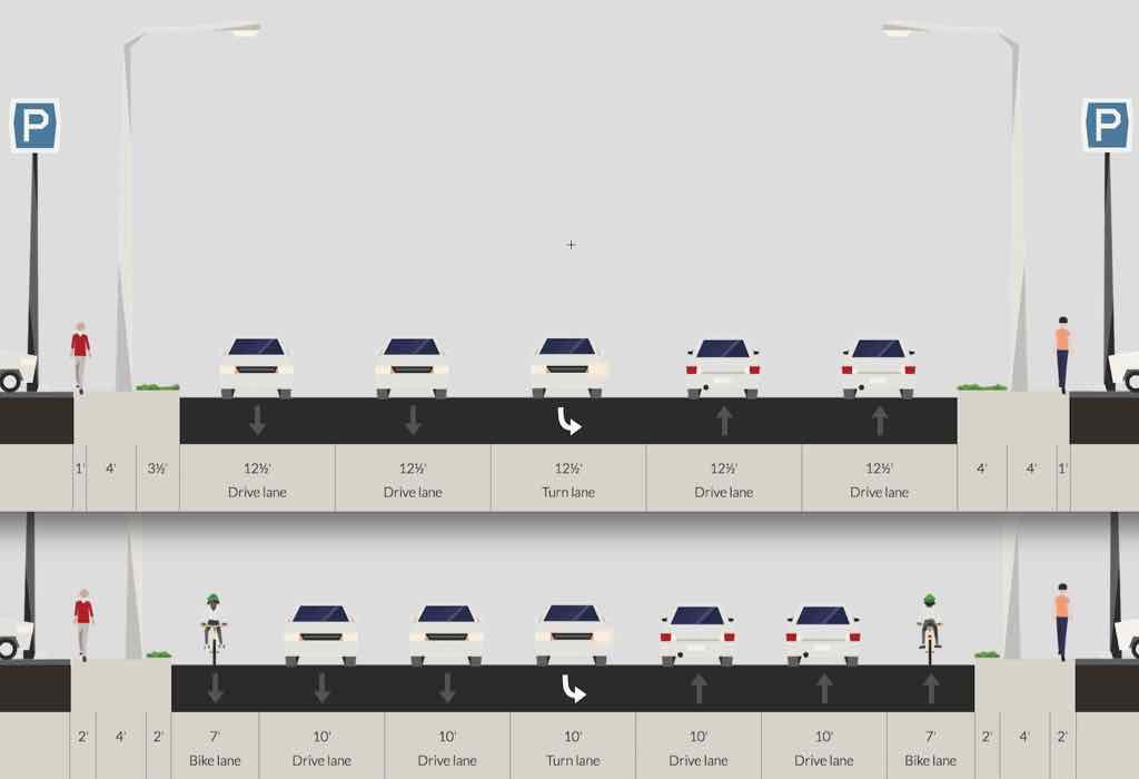
My guess is decades ago Lemay Ferry was a 2-lane road that got widened after people & businesses began moving to south county from south city. It went from a rural 2-lane to a 4-lane with center turn without any consideration for pedestrians. The 80′ right-of-way might have been in anticipation on more lanes of traffic — the land was subdivided before I-55 was even a dream.But MO-267, aka Lemay Ferry, is used by pedestrians. People use transit. Not all residents own cars.

It hasn’t kept up, but it needs to change.    Before someone gets killed!

— Steve Patterson


Most Bus Stops On A St. Clair County Route Not Designed For Pedestrians

Last week I decided to visit downtown O’Fallon IL so I could see & photograph their old city hall — which is for sale. It is just a 24-28 minute drive from my loft in downtown St. Louis but my husband and I share a car, which he uses has for work. Transit was my best option, but it would be 90 minutes each way. The first half via MetroLink light rail, the second via MetroBus.

The MetroLink stations/platforms are all wheelchair accessible, as are all MetroBus vehicles. The weak link is MetroBus stops. With thousands of stops throughout the region, a transit agency can only do so much to improve municipal/county rights-of-way. I assumed I’d be ok once I reached downtown O’Fallon so I didn’t look ahead at the stops along the way.

But on the bus I began to snap pictures as the bus stopped — in some cases as we went past stops. For those unfamiliar with riding a bus, they don’t stop at every bus stop. If you want off you must pull the cord to let the driver know you wan the next stop. A bus also stops for those waiting to board. Light rail, however, stops at every stop because they’re limited and spaced far apart.  Still, the bus stops are needed because throughout the day each and every stop will likely be used at least once.

Below are some of the images I took from the #12 MetroBus heading East from the Fairview Heights IL MetroLink station to the O’Fallon City Hall. The bus was near seated capacity when we departed the station.

One of the first few stops, just grass -- no sidewalk
One of the first few stops, just grass — no sidewalk
Entering a retail area, the stop isn't accessible at all
Entering a retail area, the stop isn’t accessible at all
Curbs & mulch at Vatterott College
This was one of the busier stops, numerous people got off the bus here.
St, Clair Square. No smoking at bus shelter. No access to out parels
St, Clair Square. No smoking at bus shelter. No access to out parcels
One of the worst stops was for Green Mount Crossing shopping center -- just a little shoulder and worn grass before quickly going downhill into a drainage ditch . Click image to see a list of business
One of the worst stops was for Green Mount Crossing shopping center — just a little shoulder and worn grass before quickly going downhill into a drainage ditch . Click image to see a list of business
Looking back toward the main automobile entrance.
Just to the North we see construction of a new building next to one bus stop.
Just around the corner the new St Elizabeth Hospital is under construction. Will they provide an ADA-compliant bus stop and route to front door? How about crossing the street to go the other direction?
The bus driver tried to let off at the bus stop nearest the city hall, but the ramp stopped short of the sidewalk and the height difference would've gotten me stuck. He had to retract the ramp , pull up to the corner, and let the ramp out again.
The bus driver tried to let off at the bus stop nearest the city hall, but the ramp stopped short of the sidewalk and the height difference would’ve gotten me stuck. He had to retract the ramp , pull up to the corner, and let the ramp out again.
I got around fine, but a missing ramp in downtown O'Fallon forced me into the street until I found a driveway. Washington & Vine
I got around fine, but a missing ramp in downtown O’Fallon forced me into the street until I found a driveway. Washington & Vine
After crossing Cherry 4th I got stuck trying to reach the sidewalk on the West side of Cherry. I had to stand up and pull my front casters onto the sidewalk. All while hoping I don't fall -- because I can't get up on my own.
After crossing Cherry 4th I got stuck trying to reach the sidewalk on the West side of Cherry. I had to stand up and pull my front casters onto the sidewalk. All while hoping I don’t fall — because I can’t get up on my own.

I reviewed the entire route on Google Street View, my stop in downtown O”Fallon was the 82nd stop after leaving the Fairview Heights MetroLink station. We traveled through Fairview Heights, Shiloh, O’Fallon, and likely unincorporated St. Clair County.

If you care to take a look, here’s a link to all the stops. Only a few I’d consider to be ADA-compliant.

Basically this is largely impossible for those of us who are disabled, but a miserable experience for the able-bodied. None of this was built with any consideration for pedestrians — everyone is expected to drive everywhere.  The reality is not everyone can drive. Physical, mental, emotional, and financial issues are some of the reasons why not everyone drives.

Sadly, this is the rule — not the exception. We’ve built so much that’s hostile to pedestrians and impossible for some of us. Tomorrow a similar example from St. Louis County.

— Steve Patterson


Another Downtown/CBD Traffic Study In The Works, Looking Back At The 2005 Study

I recently learned that a traffic study will be done for downtown’s Central Business District (CBT), a good thing.  But then I thought about the last CBD traffic study. A search of this blog turned up posts from a decade ago:

I’m a digital packrat, so I saved the presentation:

First slide of presentation, click image to view 53 page PDF on Scribd.

You can view the presentation and draw your own conclusions — I want to call attention to some of my thoughts at the time along with how things have changed, or stayed the same:

Doug Shatto, President of the consulting firm Crawford, Bunte, Brammeier did an excellent job of explaining the tradeoffs between various methods such as one-way vs. two-way streets. I felt he understands what it takes to create a pedestrian & retail-friendly environment. What I didn’t get was a sense that he will fight for that. Instead I think he’ll do whatever the city tells him.

Shatto has changed jobs.

Washington Avenue East of Tucker. While they say that on-street parking has not been ruled out I’m suspicious. They hinted at allowing parking except during peak hours. I pointed out after the meeting to Doug Shatto how KitchenK will not use their sidewalk cafe license until they have a row of parked cars to make sidewalk dining more hospitable to their patrons. I also pointed out that Copia is allowed to take a traffic lane for valet parking. If we can take a lane for a valet we can certainly take the balance of the lane for parking as the flow is already restricted. I still want to see on-street parking all the way from Tucker to at least Broadway.

Ah yes, a decade ago parking wasn’t allowed on Washington Ave East of Tucker. I did a number of posts at the time about this, finally we got limited parking on the EB block between 11th & Tucker and 10th-11th in both directions –except during morning & afternoon rush. On-street parking is still needed East of 10th, but it hasn’t happened. It’s needed to separate pedestrians from moving vehicles, reduce drive lines from four to two. The anticipated long line of WB cars turning right onto Tucker toward the new bridge never materialized, yet the rentire WB right lane from 11th to Tucker remains no-parking. Why?

I asked at the end of the meeting about Cole street being abel to take some of the traffic off Washington Avenue. Shatto did indicate that if Washington Avenue was restricted from four lanes to two lanes through drivers would likely alter their route and use the nearly vacant Cole. Another factor that may reduce some traffic on Washington Avenue is people going around the block due to one-way streets. They are recommending changing 8th & 11th from one-way to two-way (more later).

  • Streets they deemed “appropriate” to change from one-way to two-way were 8th, 11th (North of Market only), and Walnut (from Tucker to either to 4th or Broadway).
  • Streets they deemed “inappropriate” to change from one-way to two-way were 9th, 10th and Pine.
  • Streets they deemed “inappropriate but viable” to change from one-way to two-way were 6th, 7th, and Locust.
  • One-way streets not even mentioned were Broadway or Chestnut.

Balpark Village did cause portions of some one-way streets to become tw0-way again. Downtown remains confusing with one-way, two-ways, and streets that don’t go through because of vacations of blocks here and there. Decades of butchering the grid has created a nightmare.

  • The immediate plan (2006) is to change the controllers for the existing signals. This will allow them greater flexibility in controlling the signals via computer. This might include changing the timing for game days or setting the signals to flash after a certain time. I think changing the timing makes sense as this could help with special events. I’m not sure how I feel about the flashing signals after hours. Does this say we have so little going on that we don’t need normal timing? Or does it say that we change over to a pedestrian environment after hours?

Presumably the controllers were changed. Many signals themselves remain the same. Many intersections still lack any type of pedestrian signal, others need countdown timers.

  • They mentioned trying to change Missouri law to allow a left turn on red on one-way streets. Apparently this is allowed in 16 or so states but not Missouri. It is commonplace downtown to see drivers do this.

I posted about this in June — Missouri law still doesn’t allow left turns on red.

  • I think they did an excellent job of evaluating pedestrian concerns and will do a good job upgrading the system and reducing conflicts. One of the changes it to go to a simple two-phase system where pedestrians are permitted to cross with the flow of traffic. Currently some intersections are considered scrambled where pedestrians can cross any direction while cars wait. While this sounds good that also means that they are generally not allowed to cross with the flow. It seems more natural to have the simpler system.

The pedestrian experience downtown is horrible — highly inconsistent from one block to the next. With the Arch parking garage gone we’re expecting visitors to parking in garages in the CBD and walk to the new downtown-facing entry. The pedestrian experience doesn’t seen to have been given the scrutiny that traffic flow & space availability has.

Hopefully once a new plan is complete we can actually take some action!

– Steve Patterson


Macklind Ave Is An Inaccesible, Incomplete Street

At the start of this month I had an appointment with an orthopedic specialist, to get a cast made for a new ankle-foot orthosis (AFO).  Orthotic & Prosthetic Design is located at 5467 Highland Park Drive, off of Macklind Ave. between Manchester & Oakland. I’d been there before, usually driving. Once via the #59 MetroBus on Oakland — which goes as far East as the Central West End. With my husband at work with our car, I decided to take the #32 MetroBus — no transfer needed. I boarded at 14th & Washington.

This is the Eastbound #32 I took, the Macklind bus stop is just West of the intersection. I snapped this photo at 9:21am on November 2, 2015.
This is the Eastbound #32 I took, the Macklind bus stop is just West of the intersection. I snapped this photo at 9:21am on November 2, 2015. Click image to map bus stop.
The lowered section here is to be able to cross Manchester, but it's filled with debris.
The lowered section here is to be able to cross Manchester, but it’s filled with debris.
I wanted to locate the bus stop for my return trip, it's East of Macklind. The concrete pad isn't accessible -- no sidewalk to reach it. I'm forced to take a different MetroBus and transfer at the CWE or travel further East or West on Manchester until I find an accessible stop.
I wanted to locate the bus stop for my return trip, it’s East of Macklind. The concrete pad isn’t accessible — no sidewalk to reach it. I’m forced to take a different MetroBus and transfer at the CWE or travel further East or West on Manchester until I find an accessible stop. Click image to view closer view on Google Street View.
I rotated back toward Macklind to show you how far away from the intersection I was.
To head North on Macklind I can't go up the East side. The sidewalk is missing behind the corner but just out of view is a curb. My only option is the West side, which is ok because my destination is to the West.
To head North on Macklind I can’t go up the East side. The sidewalk is missing behind the corner but just out of view is a curb. My only option is the West side, which is ok because my destination is to the West.
At 9:26am I get to 1249 Macklind, owned by American Pulverizer, and see there's no sidewalk. Rather than risk getting hit in the street, I risk tipping over on uneven ground. If it had rained I might have gotten stuck.
At 9:26am I get to 1249 Macklind, owned by American Pulverizer, and see there’s no sidewalk. Rather than risk getting hit in the street, I risk tipping over on uneven ground. If it had rained I might have gotten stuck.
In front of the Humane Society I reach Wise Ave -- no curb cut on either side. I decide to go West on Wide to cross over to the other side at a driveway.
In front of the Humane Society I reach Wise Ave — no curb cut on either side. I decide to go West on Wide to cross over to the other side at a driveway.
On the North side of Wise Ave I managed to slowly get past the parking meters next to the Pasta House headquarters, but then...
On the North side of Wise Ave I managed to slowly get past the parking meters next to the Pasta House headquarters, but then…
I couldn't get past a light pole because the slope of the grass. I had to stand to get my chair reversed, all while not falling or sending my chair over the curb into the street.
I couldn’t get past a light pole because the slope of the grass. I had to stand to get my chair reversed, all while not falling or sending my chair over the curb into the street.
So I returned to the driveway off Wise and rode back toward Macklind in the street. But I can't get onto the sidewalk. I had to choice but to use Macklind Ave -- going into a drive and to go around parked cars until I reached a curb ramp or driveway.
So I returned to the driveway off Wise and rode back toward Macklind in the street. But I can’t get onto the sidewalk. I had to choice but to use Macklind Ave — going into a drive and to go around parked cars until I reached a curb ramp or driveway.
The next point was the street I needed, Highland Park Drive. No curb ramps here either, but I was able to get over this curb. Others might not be able to.
My destination is at the end of the street, but CBRE decided their sign was more important than pedestrians, I went around but the slope & condition of the asphalt was another challenge in a difficult morning, I arrived right on time at 9:40am.
After my appointment I headed North to Oakland Ave, at St. Louis Community College I encountered another curb. I used a nearby drive to once again go onto Macklind Ave to get around the lack of a curb cut. Whoever painted it yellow probably didn't think about wheelchair access.
After my appointment I headed North to Oakland Ave, at St. Louis Community College I encountered another curb. I used a nearby drive to once again go onto Macklind Ave to get around the lack of a curb cut. Whoever painted it yellow probably didn’t think about wheelchair access.

I did reach the bus stop on Oakland — in front of Paraquad.

When the Humane Society of Missouri opened their new headquarters nearly 18 years ago it seems nobody worried about pedestrians reaching the property — no sidewalk to the South and no curb cut to the North. Not sure how long the Pasta House Company has been in their location. And what if my destination had been on the East side of Macklind?

This morning I’ll email a link to this post to various people with the City of St, Louis, Metro, the Humane Society, American Pulverizer, the Pasta House Company, St. Louis Community College, Paraquad, and 24th Ward Alderman Scott Ogilvie. Hopefully they can collectively figure out a plan to make this area comply with the American’s with Disabilities Act of 1990. Twenty-five years is long enough, this shouldn’t still be like this.

— Steve Patterson


MetroBus Stop Now Visible

November 13, 2015 Accessibility, Featured, Public Transit, Walkability Comments Off on MetroBus Stop Now Visible

In September I posted about a dangerous to reach MetroBus stop, and once there it was nearly impossible for the driver to see me waiting. It stopped because a passenger wanted to get off, not because he saw me. The problem was overgrown trees just before the stop.

Looking West for the approaching MetroBus, August 2015
Looking Eastbound on November 1st

Driving down Manchester recently I noticed the overgrowth had been trimmed, as I had requested, by the City and/or Metro. Crossing Manchester at this point is still dangerous, nothing has been done to address that. In August I used this stop to take the #32 back downtown because overgrowth on the other side blocked the sidewalk — preventing me from reaching the next stop at the traffic light seen in the background. That overgrowth was also cleared.

It’s far from perfect — but it’s also far more user-friendly than before.

— Steve Patterson


Advertisement


[custom-facebook-feed]

Archives

Categories

Advertisement


Subscribe