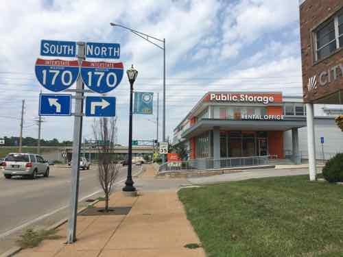
Five years ago I suggested 9th & 10th Streets through the Columbus Square neighborhood (Cole to Cass) be uncoupled so that both are two-way streets again. See Columbus Square: 9th & 10th Streets from May 19, 2014.
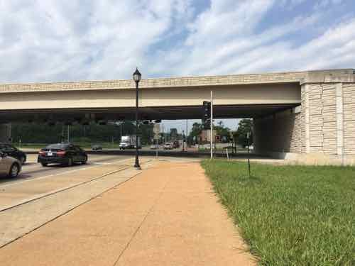
In short, 9th & 10th have been a one-way couplet (opposite directions) to facilitate vehicular travel between I-70 and downtown — passing through the Columbus Square neighborhood. Due to the construction of the Stan Musial Veterans Memorial Bridge 9th/10th hasn’t connected to I-70 in 8-9 years. Yet, these excessively wide one-way streets remain through the neighborhood.
What has changed in the last five years?
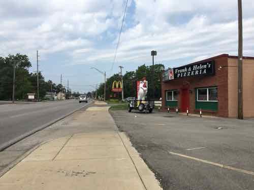
I moved to the neighborhood nearly 5 months ago and 9th Street immediately south of Cole Street will close if the convention center is expanded. Living here, frequently crossing 9th & 10th, I can tell you they’re substantially wider than necessary. Being wide and one-way their design encourages drivers to travel at much higher speeds than should be in a residential neighborhood.
Five years ago the main obstacle to correcting this problem was the cost to alter/replace 3 traffic signals. The possible convention center expansion project includes significant changes to Cole Street — including new signals at 9th & 10th. That leaves only the relatively new signal at 9th & Cass to modify — minor work since 3 out of 4 approaches is currently two-way. Some additional stop signs will be necessary at intersections between Cole & Cass.
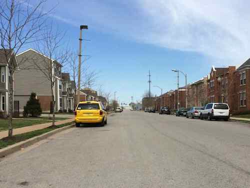
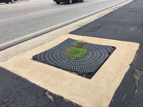
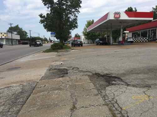
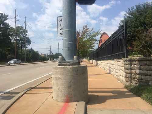
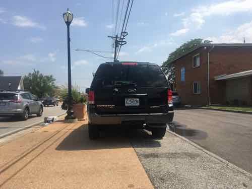
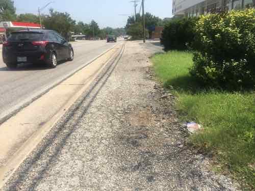
Looking North on 9th Street toward Cass. It’s 44 feet from curb to curb.
We measured the width of 9th & 10th in various places five years ago, 9th @ Manhattan Place (south of Cass) was a very wide 44 feet. For comparison, Locust at 16th is a much busier street and is 42 feet wide. You need 8 feet for each parking lane, plus a max of 12 feet for each travel lane — a total of 40 feet. I’d prefer 10 or 11 foot travel lanes. There’s no money to physically narrow the streets, but a wide center “median” could be painted with stripes.
This pair of streets should’ve been returned to two-way during the 2010-2013 bridge project, but they weren’t. With the convention center project closing 9th and altering Cole, we’ve got another opportunity to correct the problem of one-way highway access streets through the center of a neighborhood — with an elementary school in between.
The recent non-scientific Sunday Poll was about closed streets and crime, prompted by a news story about new research at Saint Louis University:
St. Louis’ often-interrupted street grid is the outgrowth of the 1970s-era “defensible space” strategy to address rising crime championed by Oscar Newman, a prominent urban planner who was a Washington University architecture professor in the mid-1960s, according to the paper. That idea stems from the notion that an area is safer when residents feel a sense of ownership and control, which Newman described as allowing neighbors to focus their attention on “removing criminal activity from their communities.”
St. Louis became the birthplace of such ideas, according to the paper. And they haven’t had the desired effect. (Post-Dispatch)
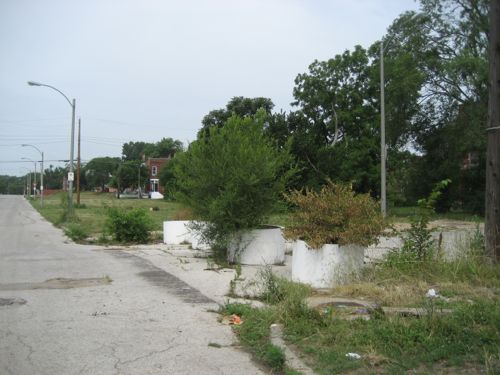
Below is one such example where “Schoemehl pots”, just sections of sewer pipe, were used to limit vehicular traffic.
Schoemehl pots used in their traditional role of messing up the street grid, 2012 photo.
Their paper’s conclusion:
Oscar Newman’s defensible space theory is a product of St. Louis’s mid-century history. It is perhaps unsurprising, therefore, that St. Louis also offers a large-scale implementation of defensible space in the street barriers that constrict swaths of the city’s geography. The barriers scattered across the city’s landscape are a testament not only to former Mayor Vincent Schoemehl, the elected official most closely associated with the barriers, but to Newman himself. We have developed the most comprehensive known list of closures in the city, and find that the density of closures is not associated with less crime in neighborhoods. Our finding is an important one for St. Louis, given that addressing crime is the argument being made explicitly in the legislation that authorizes more recent installations of barriers. For other municipalities that may be considering defensible space or other techniques to “design out” crime, our findings suggest that street closures are at best ineffective and at worst associated with higher rates of violent crime in neighborhoods. They may also have secondary effects on first responders’ ability to reach the neighborhoods they serve. (Research paper)
I completely agree with the conclusions of the researchers, but I also think they should be looking at earlier changes to the urban street grid. As I’ve said before, when Harold Bartholomew (1889-1989) first arrived in St. Louis in the nineteen teens he quickly began assaulting our fine network of public streets. Writing decades later in the 1947 plan:
Since 1916 St. Louis has expended over $40,000,000 in opening, widening, connecting, and extending the system of major streets. Much has been accomplished in converting a horse and buggy street system to automobile needs. As the total volume of traffic increases, however, certain new needs arise. An example is the desirability of grade separations at extremely heavy intersections, such as at Grand and Market and at Kingshighway and Lindell. Likewise there is a need for complete separation of grade where traffic volume is sufficiently heavy to justify the cost involved. The Federal Government, which has helped finance our splendid system of national highways, has recently revised its policies and Congress has appropriated substantial funds to aid the cities in the construction of express highways and for facilitation of traffic flows from certain selected state highways through metropolitan areas to the central business districts of large cities. (1947 Plan)
In just three decades St. Louis spent today’s equivalent of nearly a half a billion dollars on dramatic changes to the street grid. Half a billion!
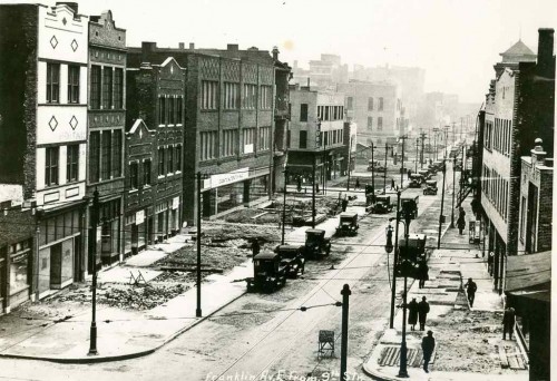
Franklin Ave looking East from 9th, 1928. Collection of the Landmarks Association of St Louis
The reference to the “horse and buggy street system” illustrates he didn’t think it was suitable for the automobile. Bartholomew, a civil engineer by training, was no doubt influenced by the City Beautiful movement.
City Beautiful movement, American urban-planning movement led by architects, landscape architects, and reformers that flourished between the 1890s and the 1920s. The idea of organized comprehensive urban planning arose in the United States from the City Beautiful movement, which claimed that design could not be separated from social issues and should encourage civic pride and engagement. (Britannica)
This was soon followed by the modernists and their vision for roads to connect everything. The Futurama exhibit at the 1939 World’s Fair was hugely popular, helped shape legislation that let to destructive urban renewal projects, interstate highways slicing through cities, etc. See original 23-minute 1939 Futurama promo video.
Oscar Newman was born in 1935, so he was barely around during the 1939 fair. With the Great Depression & WWII the ideas from Futurama were on hold until he was a teen. Newman likely went along with most others, not foreseeing any problems with additional alterations to the street grid.
By the time republished his 1972 book urban renewal & highway projects had further disrupted the street grid beyond recognition. These changes are cumulative, not isolated. Our street grid was designed for the horse and buggy times — but that’s what made it go great. Street grids can take little changes and still function. St. Louis had decades of massive overwhelming changes to the street grid.
It has proven to be excessive. Abandonment, crime, etc are the results. I don’t know that it’s repairable.
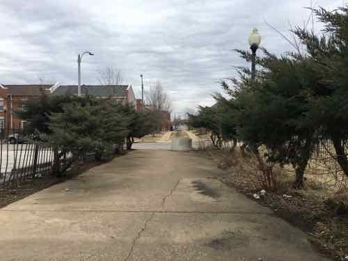
Former Biddle Street, looking East toward 9th Street
The results from Sunday’s non-scientific poll:
Q: Agree or disagree: City streets closed to through traffic reduce crime.
Strongly agree: 1 [3.13%]
Agree: 2 [6.25%]
Somewhat agree: 6 [18.75%]
Neither agree or disagree: 2 [6.25%]
Somewhat disagree: 2 [6.25%]
Disagree: 9 [28.13%]
Strongly disagree: 9 [28.13%]
Unsure/No Answer: 1 [3.13%]
More than half correct don’t think closed streets reduce crime.
University City Missouri is a first-tier suburb of St. Louis. Many towns in the region are older, starting as rural villages. More than a quarter century after the municipal boundaries of the City of St. Louis were set in stone way out in the rural countryside, U City began at those limits:
University City was founded by publisher Edward Gardner Lewis, who began developing the location in 1903 around his publishing complex for Woman’s Magazine and Woman’s Farm Journal. Historic buildings associated with municipal operations, including today’s City Hall, were built by Lewis as facilities for his magazine enterprise. In 1906, the city incorporated and Lewis served as its first mayor. (Wikipedia)
The streetcar from the city was extended West into the new suburb, turning around there. The urban business district is now knows as the Delmar Loop because of the streetcar loop to reverse direction.
University City has a second East-West business district: Olive Boulevard. Where the Delmar Loop was established first, in the streetcar era, Olive developed later. Initially buildings were similar to those on Delmar: 2-story with residential over a business on the ground floor. As development marched Westward the automobile became more important and residential units above retail was no longer a thing — it was all about separation of uses. Business zoning meant businesses only, residential meant single-family detached homes, with a few zones for multi-family. Mixing these was considered a formula for creating blight.
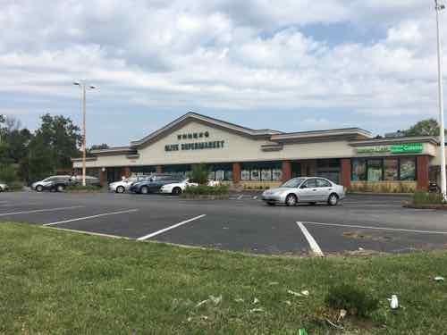
As a result, the 3.6+ miles of Olive Blvd has always been very different than the short half mile of the Delmar Loop business district located within University City’s limits. On Saturday August 25 2018 I decided to explore a portion of Olive Blvd targeted for redevelopment. Today’s post isn’t about proposed development and all the pros & cons associated with it. No, today is about documenting what exists now. My round trip took more than four hours, including stopping for lunch to eat and recharge my wheelchair. In that time I took 181 photos.
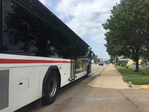
It was quite hot on that Saturday, but I feel it’s important to personally experience an area before writing about it. I’m not going to share all my images, just enough to give you a sense of the area. The #91 MetroBus starts at the Delmar Station (I arrived on the #97 MetroBus, not via MetroLink). Anyway, the #91 heads North on Skinker before turning left to head Westbound on Olive Blvd. — the start of the U City limits.
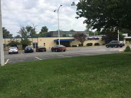
Having lived in St. Louis for over 28 years I’d driven this part of Olive many times, but this was my first time seeing it from the bus window. My interest on Saturday, however, was the far end of Olive. I got off the bus in front of Royal Banks (map). Before I get into my photos illustrating Olive Blvd I should give you some additional background. Neither University City or St. Louis County is responsible for maintenance of the road, sidewalks, signals, etc. The State of Missouri has that responsibility because Olive Blvd is also known as state Route 340.
Route 340 is a highway in the St. Louis metropolitan area. Its western terminus is Route 100 (Manchester Road) in Ellisville, and its eastern terminus is at an intersection with Ferguson Avenue and Olive Boulevard in University City. The stretch of Route 340 between Manchester Road and the Interstate 64 / U.S. 40 / U.S. 61 interchange is known locally as Clarkson Road. The remainder of Route 340 between this intersection and its eastern terminus is variously known as Olive Boulevard (which does not connect with Olive Street in the city of St. Louis. Route 340 ends at Ferguson Avenue in University City, but Olive Boulevard continues to Skinker Boulevard on St. Louis city line. (Wikipedia)
Not a divided limited-access interstate, but an urban corridor that is supposed to move more cars than other corridors — like Delmar Blvd. The headline gives away the theme — it was a nightmare. This comes from auto-centric development in the absence of a mandate for accommodating pedestrians.
OK, let the visual tour begin.
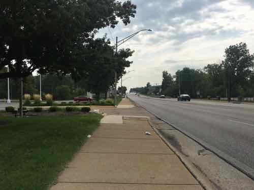
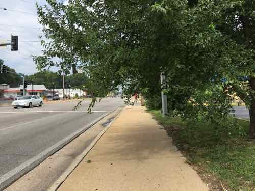
Taken on the bus, this 1915 building has residential above commercial. This is shortly before Olive Blvd becomes Missouri Route 340. Due to parking, clear pedestrian access is limited.Looking West as the bus continues heading on Olive Blvd to Chesterfield Mall.Looking East from the same spot. Olive Blvd is 4 travel lanes, plus a center turn lane. Sidewalks at this point are “attached”, no tree lawn separating roadway from sidewalk.The Royal Banks building, 8021 Olive Blvd, was built in 1971. In 1958 the land was vacant.Next door, to the West, is a store specializing in Asian/International groceries. It was built in 1960 — has been updated many times since. Both are set way back from Olive to provide more room for parking.
Despite the presence of a bus stop, neither provide an accessible route to their accessible building entrance. This is the case for nearly every property I encountered the next few hours.
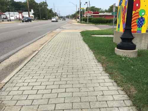
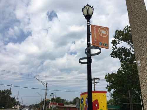
I quickly encounter a point where foliage is hanging over the sidewalk. I’m sitting in my wheelchair and still hit it when ducking.In places the paving changes to a paver brick intended to spruce up the pedestrian experience. As expected, they were uneven.The streetlight is also intended to help the image of Olive. The banner is for the Olive Link International district, next to rings meant to hold planters.This shows a 1962 pizza place is relatively close to Olive.Broken grate around a former street tree.
The above was written back in August, shortly after taking the trip on Olive. Rather than continue procrastinating, I’m going to post more pics with limited commentary to be able to finish this post.
One of many places where no curb cut exists, there’s a good ramp across the street but not this side
Yesterday as I was finishing up this post I reviewed all nearly 200 photos I took that hot August day. After wishing it wasn’t so cold now, I recall all the obstacles I encountered in my wheelchair. I also thought about how horrid the environment is for anyone to experience as a pedestrian.
Now that I’ve finally gotten this post completed, I can post about plans to redevelop the Western end of Olive Blvd in University City.
December 3, 2018Featured, WalkabilityComments Off on St. Louis City Pedestrians Finally Getting A ‘Leading Pedestrian Interval’
A significant change has been happening at St. Louis intersections: the leading pedestrian interval (LPI). The what?
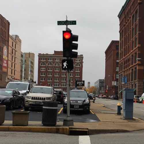
Walk signal is on while the traffic signal is still red, 11th @ Locust.
A leading pedestrian interval (LPI) gives pedestrians the opportunity to enter an intersection 3-7 seconds before vehicles are given a green indication. With this head start, pedestrians can better establish their presence in the crosswalk before vehicles have priority to turn left. LPIs provide the following benefits:
Increased visibility of crossing pedestrians.
Reduced conflicts between pedestrians and vehicles.
Increased likelihood of motorists yielding to pedestrians.
The FHA says the benefit is a 60% “Reduction in pedestrian-vehicle crashes at intersections.” Video I took last month shows a 3-second LPI. Hopefully busier intersections (pedestrians & cars) get 7 second LPIs. Still. 3 seconds is better than 0!
I’m not sure if an LPI is used anywhere in St. Louis County, or the rest of the region.
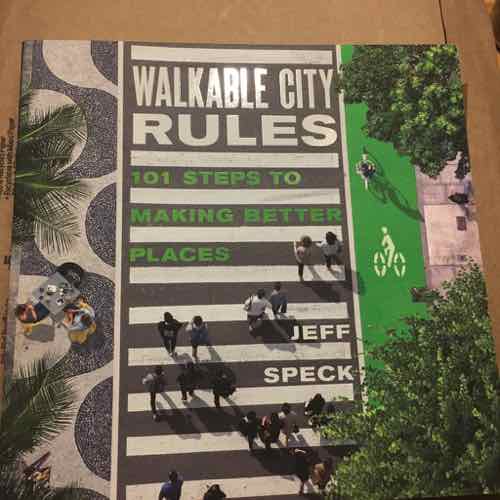
November 23, 2018Books, Featured, WalkabilityComments Off on New Book — ‘Walkable City Rules: 101 Steps to Making Better Places’ by Jeff Speck
I’m usually unbiased when publishers send me new books, but I’m a huge fan of Jeff Speck’s work as a New Urbanist planner. His latest book focuses on one of my favorite topics: walkability:
“Cities are the future of the human race, and Jeff Speck knows how to make them work.” —David Owen, staff writer at the New Yorker
Nearly every US city would like to be more walkable—for reasons of health, wealth, and the environment—yet few are taking the proper steps to get there. The goals are often clear, but the path is seldom easy. Jeff Speck’s follow-up to his bestselling Walkable City is the resource that cities and citizens need to usher in an era of renewed street life. Walkable City Rules is a doer’s guide to making change in cities, and making it now.
The 101 rules are practical yet engaging—worded for arguments at the planning commission, illustrated for clarity, and packed with specifications as well as data. For ease of use, the rules are grouped into 19 chapters that cover everything from selling walkability, to getting the parking right, escaping automobilism, making comfortable spaces and interesting places, and doing it now!
Walkable City was written to inspire; Walkable City Rules was written to enable. It is the most comprehensive tool available for bringing the latest and most effective city-planning practices to bear in your community. The content and presentation make it a force multiplier for place-makers and change-makers everywhere. (Island Press)
I received my review copy last month
He’s done two Ted Talks — back to back 5 years ago:
AARP Livibility Index
The Livability Index scores neighborhoods and communities across the U.S. for the services and amenities that impact your life the most
Built St. Louis
historic architecture of St. Louis, Missouri – mourning the losses, celebrating the survivors.
Geo St. Louis
a guide to geospatial data about the City of St. Louis