Home » Walkability » Recent Articles:

If We Want Conventions We Need To Start Over

December 9, 2021 Downtown, Featured, Planning & Design, Politics/Policy, Walkability Comments Off on If We Want Conventions We Need To Start Over

My previous post on the convention center was back in July, see: The St. Louis Region Needs to Consider No Longer Chasing Big Conventions. Basically I said leave just a little and tear down the rest. This would allow new private development and reconnect the neighborhood north of the complex to the downtown central business district (CBD) — 6th, 7th, and 8th streets have been closed for years and 9th will close if the current plan moves forward.  In September the CEO of Clayco Construction, Bob Clark, proposed another alternative to the current plan.

The current plan adds more lipstick to our nearly 45 year-old pig, fixing problems created by prior applications of quick fix solutions: ballroom next to the kitchen, improved loading docks, more space, adjacent outdoor space, etc. The goal is to go after conventions that have eluded us due to inadequacies in our facilities.

My solution was to simply stop chasing after them and reconnect a neighborhood that was intentionally cut off.  It is also the neighborhood where I live. So in September I was happy to see an influential CEO weigh in on the topic, but go the opposite direction.

St. Louis should scrap its $210 million convention center addition in favor of a larger, $800 million plan that would see the current downtown facility and Dome demolished, Clayco CEO Bob Clark said.

Clark said he’s pitched the larger plan to area officials for two and a half years, but is going public now because federal infrastructure money could be coming to St. Louis and a potential settlement with the National Football League looms over the Rams’ 2016 exit to Los Angeles. And Clark thinks the state of Missouri could contribute to the more ambitious proposal, solving a funding problem that limited the current plan’s scope. (St. Louis Business Journal via KSDK)

Late last month St. Louis (city of St. Louis, St. Louis County, and the Regional Convention and Sports Complex Authority) settled with Kroenke/NFL, with the former receiving $790 million dollars (before attorney’s fees).

The current main entrance at 8th & Washington Ave. was part of a major 1993 expansion to the 1977 original.

Here is Clark’s post on his personal blog:

Over the years, St. Louis has missed a lot of great opportunities to revitalize its downtown neighborhoods. From losing out on railroads to Chicago to failing to merge the city with St. Louis County, so many things have happened throughout the city’s history that still prevent it from being as good as it can be. With renewed attention on reimagining the downtown convention center, I’m calling for a larger, more ambitious plan to be considered that would completely transform the city for the better.

With additional funding opportunities coming from federal infrastructure spending, a potential settlement with the NFL, and additional state funds, we have a real chance to think bigger and put forth even better ideas for America’s Center, like my proposal to build a convention center that would boost business and better connect north city neighborhoods to downtown.

Modeled after the convention center in Nashville, Tennessee, our plan envisions a modern convention center for the future that would occupy a three-block footprint near the Bottle District stretching from Carr Street south to Convention Plaza. It would provide more exhibit and meeting space and also connect to the NoW Innovation District that is already generating positive results for job growth and the local economy. And it would also play a part in keeping the city safer, since it would provide better access between the city’s northern neighborhoods and southern neighborhoods going right through downtown.

This is a project that gives us a great opportunity to build a better city for St. Louisans and share what we have to offer with visitors from all over the world. It would help solve some of the most pressing issues we face as a city, and I’m urging our local elected officials to consider it further.

Clark is correct that just adding on more space to be able to check boxes isn’t the right approach if we actually want to be seriously considered for some convention business. Yes, I’ve posted about how cities keep wasting big bucks chasing conventions, see  Convention Center Follies: Politics, Power, and Public Investment in American Cities by Heywood T. Sanders from 2014. It seems to me it’d a bigger waste of money to keep attempting to make a half-ass facility into a competatibvr .

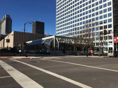
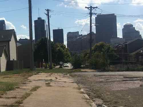
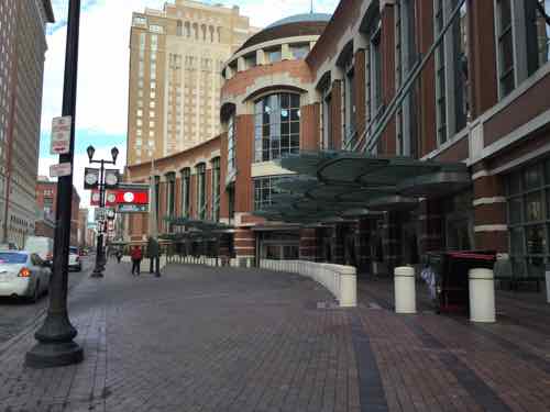
The current configuration occupies 12 city blocks (11 plus a privately owned garage surrounded on 3 sides).  If the current plan goes ahead it’ll add a 13th city block. While it may then be able to check off boxes on convention event planner’s must have lists the reality is it’ll still be a spread out mess that separates the city with a huge monolithic mass with Broadway (5th Street) on the east and 10th Street on the west.

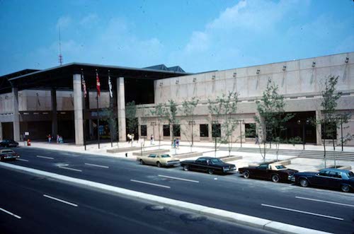
Our original 4-block Cervantes Convention Center, which opened in 1977, is still in the center of our current facility.

Cervantes Convention Center. 801 Convention Center Plaza. St. Louis Mo. August, 1977. Photograph (35mm Kodachrome) by Ralph D’Oench, 1977. Missouri Historical Society Photographs and Prints Collections. NS 30747. Scan © 2006, Missouri Historical Society.

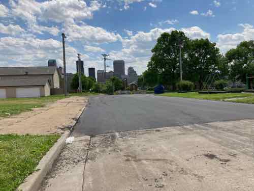
To the north of this mass only 8th street is closed, occupied by apartments. Sixth, 7th, and 9th all still exist in the neighborhood. The most recent plan for a north-south light rail plan includes a little bit of 9th, so the planned route would have to change.

So I’m agreeing with Bob Clark, if we want convention business we should start over with a clean slate. I haven’t been to Nashville since the Music City Center was constructed, but I looked at the website, photos, interior 360º views, aerial, and Google Streetview. Nashville’s convention center is 3 blocks long, 2 blocks wide. One city street continues through/under the building — I walked through via streetview. From the outside you cannot see the loading docks, one side is highly approachable with outdoor seating and businesses that can serve convention attendees as well as locals.

The main takeaway of Nashville’s center relative to Clark’s proposal is the street that continues rather than being vacated. In. St. Louis that allows a 3-block long convention center to orient north-south, next to the dead space known as the elevated I-44 interstate. Another is building up, not out. We’re a city, downtown buildings shouldn’t largely be single story.

View of Bob Clark’s proposal, click image to see larger view.

I’m not advocating we build Clark’s idea, I’m suggesting we start over from scratch. We’ve added on and altered the convention center built 45 years ago to the point it’s a sprawling mess. The Nashville center can’t compete with Chicago’s McCormack Place in terms of size, but it has the same light-filled open airy feeling. Our current facility will never have that. Never.

Here’s what I like about Clark’s proposal:

  • Fresh start, better for 21st century needs.
  • North-south orientation along Broadway (5th).
  • Better connection  to Laclede’s Landing.
  • Cole Street (east-west) continues uninterrupted.
  • Sidewalk-level opportunities for storefronts around entire building, including along Cole.
  • A big massive building doesn’t separate the downtown CBD from the neighborhood north of Cole.
  • The long-vacant land north of Cole Street is utilized.
  • Vacant land to the west can be filled with new buildings, users, opportunities, tax revenue.

Here’s what I don’t like about Clark’s proposal:

  • The outdoor event space (Baer  Plaza) between Broadway and I-44 is horrible. Conventioneers attempting to cross Broadway would get hit by the speeding one-way traffic. Broadway should be 2-way and this land should have hotel, apartments, condos, etc. Some of any new residential should be workforce housing and low-income housing.
  • 7th, 9th, and 10th streets all need to be rebuilt/continue uninterrupted between Washington Ave and Cole — for pedestrians and vehicles.
  • Not sure keeping the existing curved entrance is a good idea.
  • No green roof or solar panels like they have in Nashville.
  • Convention Plaza needs to return to its previous name: Delmar.

The important thing is to put the brakes on the current expansion plan and take a fresh look at what it means to offer a convention center — not just how can we make a nearly half century old place less objectionable to convention planners. If we move forward with the current expansion plan we’ll be stuck with a bloated pig for at least another 20-30 years.

— Steve Patterson


Last Mile to Cahokia Mounds Is Impossible For Pedestrians

September 27, 2021 Accessibility, Featured, Metro East, Walkability Comments Off on Last Mile to Cahokia Mounds Is Impossible For Pedestrians

I’ve working on my bucket list in the last two years living with stage IV kidney cancer. Right after Memorial Day I was able to visit Milwaukee, my very first time in Wisconsin. I’m also working on items closer to home that I can safely do during a pandemic. To help me I pulled the 2013 book 100 Things To Do In Saint Louis Before You Die off my bookshelf.  One of several books written or co-authored by my longtime friend Amanda Doyle.

Well, I don’t see myself being able to physically sled down Art Hill, or use a paddle boat in Forest Park. Hmm, visit Cahokia Mounds? I’ve always wanted to see it, it’s likely the only additional  World Heritage site I’ll be able to visit — I’ve been to Independence Hall & many Frank Lloyd Wright buildings, including Fallingwater.

Embarrassingly in my 31+ years living in St. Louis I must admit I’ve never once visited Cahokia Mounds, a World Heritage site only a 15-minute drive into Illinois from St. Louis. Like so many places I thought I could go  &  things I could do in the future, until I became disabled a month before my 41st birthday. I had lived here less than 18 years before I had a massive stroke, meaning I couldn’t walk around the large Cahokia Mounds site. My power wheelchair allows me to “walk” around places like the Missouri Botanical Gardens.

In case you’re unfamiliar with Cahokia Mounds:

The remains of the most sophisticated prehistoric native civilization north of Mexico are preserved at Cahokia Mounds State Historic Site. Within the 2,200-acre tract, located a few miles west of Collinsville, Illinois, lie the archaeological remnants of the central section of the ancient settlement that is today known as Cahokia. (Cahokia Mounds Museum Society)

The fastest way there is for me and my husband to just drive there. But, I couldn’t see much because I can’t walk far. I also have a manual wheelchair we can put in the trunk, but he’d have to push me or I use my right foot and right hand to propel myself. One of us would get worn out.

I’ve traveled to five different states using transit and my power wheelchair so I should be able to go less than 10 miles. So I looked. Yes, I can roll 8/10 of a mile to the Convention Center MetroLink light rail station, take the train east to the Emerson Park station, and then catch the #18 Madison County bus northbound to Fairmont Ave at Collinsville Rd. Then it’s just a mile west along Collinsville Rd to the entrance to Cahokia Mounds State Historic Site (map).

A mile isn’t an issue at all, a week ago I rolled almost 5 miles home from Siteman Cancer Center. Yes, returning home on MetroLink would’ve been considerably faster but I got to see a lot of stuff along my route. I’m on disability so I’m usually not in a hurry. So what’s the problem?

The problem is Collinsville Road is a high-speed (45mph) 4-lane roadway with zero pedestrian infrastructure. None. No pedestrian signals or crosswalks at the signalized intersection near the bus stop. A few businesses near the intersection have a public sidewalk but they’re not connected to each other. Most of the mile distance is just a very tiny shoulder and a ditch. If I were somehow to make it I’d need to cross Collinsville Rd. Opposite the entrance to Cahokia Mounds is a pedestrian sign, but trying to cross 4 lanes of high-speed traffic is a death wish.

Approaching Cahokia Mounds from the east you see it on the left. On the right is a pedestrian crossing ahead sign, next to the ditch.
Further up as you get close to the entrance the road splits so there’s a center turn lane. On the right is a Cahokia Mounds sign pointing drivers left. The driveway to the right has a culvert under it so any water in the ditch can continue to flow.

My thoughts turned to contacting someone to bug them about this. But who? Most of the north side of Collinsville Rd is in Namioki Township, Madison County. Part of the south side of Collinsville Rd & Cahokia Mounds are in Collinsville, St. Clair County. Yes, most of Collinsville is in Madison County, but this part is in St. Clair County. And finally  the the intersection of Collinsville Rd & Fairmont Ave/Black Lane is State Park Place, an unincorporated community in both Madison & St  Clair Counties. Maddening fragmentation!

I suppose an able-bodied person could navigate this last mile, but I doubt anyone would.  Back at State Park Place there’s business on both sides of Collinsville Rd, including a Mexican restaurant on each side. I read somewhere a while ago that one is among the best Mexican restaurants in the Metro East.

My first task will be to contact Cahokia Mounds to see if they have any power wheelchairs/scooters for rent, their website doesn’t mention accessibility at all. I’ll also contact the Highway Dept at each county, though it might take state and/or federal funds to get anything built. I just want to get things…rolling.

Steve Patterson


Mid-70s Downtown Office Tower Getting Needed 21st Century Update

August 12, 2021 Downtown, Featured, Planning & Design, Real Estate, Walkability Comments Off on Mid-70s Downtown Office Tower Getting Needed 21st Century Update

Office vacancy rates are high now, especially in downtown St. Louis.

Office vacancy is up across the metro area, averaging 16.9% in the second quarter of 2021 compared with 11.8% in 2020. Rents for offices outside of downtown declined nearly 4% from the end of 2020 through the second quarter of 2021, according to commercial real estate firm Cushman & Wakefield.

Vacancy downtown has risen more than 1 percentage point in the past year, to 20.8% from 19.3% in the second quarter of 2020. And rents have fallen by more than 1% to $19.48 per square foot. (Post-Dispatch)

One downtown office tower, recently acquired by a local fund, is taking steps to reverse years of increased vacancy.

The 4th & Chestnut corner of 100 North Broadway. The former bank pavilion is getting a long-needed update.

Readers might recall my December 2015 blog post on this building. In that post I suggested connecting the low pavilion portion to the adjacent sidewalks, orienting the interior space to take advantage of the location and views.

To refresh your memory, here’s a view of what the exterior looked like for the first 45 years. Awful, right? Zero connection to the sidewalks. The east & west plazas weren’t inviting.  December 2015

I sent the then building owner, a San Diego-based capital firm, my post at the end of 2015. They responded the next month, I met a local property manager on site. They sent me a nice fruit basket from Harry & David.  They didn’t do anything.

Looking at the building from the NW corner of the Luther Ely Smith Square. December 2015. This is the same corner as the first corner, above.

According to KSDK more tenants left, the California owner defaulted, and by February 2019 the lender had taken over the property.  A new local owner purchased the tower and apparently recognized the need for major updates to the prominent pavilion, inside & out.

The SW corner of the property, at Broadway & Chestnut. This is diagonally across from Kiener Plaza, which reopened in 2017 after a major redesign.

The new owners logically hired one of the remaining tenants to update the interior & exterior:

Larson Capital Management has engaged Trivers to make both interior and exterior building improvements to the 2-story atrium structure and surrounding plazas and streetscape to comprehensively update and reposition the Broadway Tower as a premier office building destination in downtown Saint Louis.

Exterior improvements include removing the “greenhouses” and reimagining the Atrium façade materiality and line of enclosure, updated entrances and entry canopies, surrounding site improvements and landscaping, and public art and placemaking components creating public outdoor destinations.

Interior improvements are geared toward creating an abundance of tenant amenities including a best-in-class conferencing center, co-working lounges with hospitality support, a walking track, and access to outdoor work spaces. The Atrium will also include a new café with indoor/outdoor seating connected to the west plaza along Broadway, a new monumental stair, a large greenwall, building management offices, new security desk and updated elevator lobbies, restrooms to support the proposed uses, and comprehensive lighting, casework, and finishes upgrades. (Trivers Architects)

In 2015 I imagined a few restaurants to fill the space, but tenant amenity space will be critical to filling vacancies. There will be one cafe, on the corner shown above.

This is a crop of the previous photo, you can see how the ground floor is set back so the upper level provides shade, room for cafe tables.
The artist rendering shows this corner. The exterior cladding on the pavilion will offer more texture than the tower portion.

I’m looking forward to seeing the finished product, experiencing the revised plazas, eating at the cafe. The upper level features a covered outdoor space on the opposite corner, facing the Arch. Not sure if that will be public or tenant-only. Either way, to pedestrians at 4th & Chestnut it’ll be perceived as inviting.

— Steve Patterson


Jamestown Mall Site Part 2: Laying Groundwork For New Development Over The Coming 10+ Years

July 22, 2021 Featured, Planning & Design, Retail, St. Louis County, Walkability Comments Off on Jamestown Mall Site Part 2: Laying Groundwork For New Development Over The Coming 10+ Years
Aerial view of the site and immediate surroundings. Source: Apple Maps. Click image to view aerial in Google Maps.

Last week I outlined the problems with the vacant Jamestown Mall, its massive 144.51 acre site, and the surroundings. See Jamestown Mall Site Part 1: Analyzing the Site, Problems, and Options. When you look at the problems the solution becomes obvious.

Problems > solutions include:

  • Vacant 422,533 square feet enclosed mall > tear down mall.
  • Lack of a major grocery store > include site for ALDI-sized grocery store on edge of master plan. Building should be easily connected to new sidewalk network.
  • MetroBus stops along both sides of Lindbergh Blvd adjacent to the site are just shoulder on a state highway, discouraging pedestrian use. No pedestrian infrastructure or access to site > reroute MetroBus through the redesigned site and/or add pedestrian infrastructure along this stretch of Lindbergh Blvd.
  • The Fox Manor subdivision is immediately south of the site, downhill. It only has one way in/out — onto Lindbergh Blvd for cars only > connect the two dead end subdivision streets to new public streets on the site.

Finding a single developer to build out the nearly 145 acre site is proving difficult. Of course, it’s massive. It’s way too much for one entity to take on. Yet most people think if one developer won’t build the mixed-use neighborhood that area residents want then one developer should be allowed to development an awful warehouse complex. Wrong!

The best places in the St. Louis region weren’t built at one moment, by one developer. No, land owners subdivided their land and created building lots, putting in streets & utilities to support those who would eventually buy a lot and build on it.  This is how downtown St. Louis was developed, as well as Kirkwood MO, Florissant MO, Belleville IL. Nearly every pre-WWII downtown or commercial district developed in this manner, over time. New Town at St. Charles was planned by one developer, who also built some buildings. But not all.

St. Louis County needs to master plan the entire site, put in connecting streets & utilities, rezone the site and adopt a form-based code to guide the build out over the next 10-15-20 years. Subdivide the land so a grocery store could own their parcel.  An insurance agent might build their housing unit over their office space. A multi-family housing company might build a few buildings with apartments. A home builder might build on some single family lots.

“There is only one way to eat an elephant: a bite at a time” — Desmond Tutu

Ok. don’t eat an elephant…or even kill one. And don’t expect developers to bite off more than they can chew.

For comparison most of downtown’s central business district would fit in the same 145 acre site: From the Arch grounds to 8th, from Market to Washington Ave.

Ballpark Village is 10 acres and the Cardinals had to split that up into multiple phases because they learned they couldn’t do it all at once.  The Streets of St. Charles project is a 27 acre suburban mixed-use project and it is being phased in.

The Streets of St. Charles, 2016

Below is my crude schematic showing new streets (blue) connecting to all 7 existing site access points, including 2 dead end streets in the residential subdivision to the south. The pink is commercial and/or mixed use, the orange is residential without commercial. The green around the perimeter is a green buffer around the perimeter with a walking path, water, fruit trees, etc.

Click image to see larger version.

My roads shown above in blue would be initial roads. Maybe. At a minimum three of the seven site access points should be connected: one off Lindbergh Blvd, one off Old Jamestown Rd, and one of the two dead end streets in the Fox Manor subdivision. My idea the initial streets 1) have an intersection in the commercial area and 2) connect to the residential subdivision.

Eventually there would potentially be many more streets given the size of the site, but that can happen over time as demand warrants.

A concept from a decade ago with more of the site built out than what I envision.

My main point is the St. Louis County Port Authority, as property owner, should plan it out, put in some streets and utilities and begin to sell the land lot by lot. I think most everyone would agree a well-connected mixed-use neighborhood with a grocery store is the best possible outcome. I just don’t see it happening all at once, but incrementally over time.

— Steve Patterson


Few Exposed Brick Pavers Covered With Asphalt

June 10, 2021 Featured, North City, Transportation, Walkability Comments Off on Few Exposed Brick Pavers Covered With Asphalt

Most older streets in St. Louis were paved in cobblestones or paver bricks, few exist anymore.  Asphalt paving is significantly smoother, just far less attractive. In 1953 the Cochran Gardens high rise public housing complex opened, but construction closed off 8th Street between O’Fallon Street and the alley south of Cass Avenue. Eighth Street was reopened when the high rise towers were replaced with the mixed-income Cambridge Heights townhouses & apartments, except 8th wasn’t connected through to the little stub of a street to Cass.

This October 2, 2019 view is looking south on 8th from Cass. You can see the land just after the alley, Cambridge Heights, and the downtown skyline on the horizon. In the foreground you can see brick pavers. It looked like it had been paved over decades ago, but most was long gone so the old bricks were exposed.
On May 5th I returned home tfrom a press conference at the Chain of Rocks water treatment plant to see city crews paving over the small amount of bricks.
Closer view
A couple of days later I went back to see the finished results.The concrete in the foreground was part of the new river bridge project, when Cass was raised in height over the interstate.

This half block of 8th Street gets very little traffic, the uniformity of the asphalt paving does look better than it did with patches of old asphalt and broken bricks. This is better, but I still miss seeing the bricks.

— Steve Patterson


Advertisement


[custom-facebook-feed]

Archives

Categories

Advertisement


Subscribe