February 11, 2019Featured, Planning & Design, South CityComments Off on Thinking about the former Ackerman Toyota site on South Kingshighway
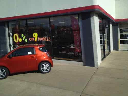
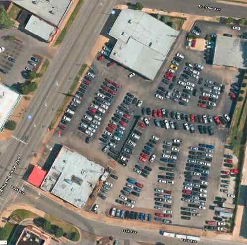
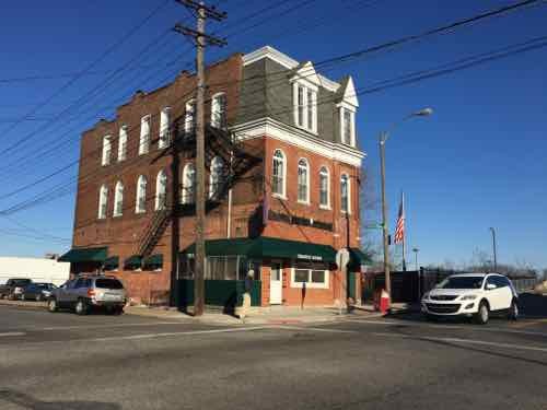
For decades Ackerman Toyota was located on South Kingshighway Blvd, between Tholozan Ave on the North, and Beck Ave on the South. In 2015 they announced they’d build a new dealership on the NE corner of Hampton & I-44, the site of the former MSD headquarters.
Ackerman Toyota, the southern outpost of the decades-old string of St. Louis car dealerships on South Kingshighway, is hitting the road.
After nearly 27 years at 3636 South Kingshighway, the dealership plans to move to 2000 Hampton Avenue. The three-acre site owned by the city’s Land Clearance for Redevelopment Authority is the former headquarters of the Metropolitan St. Louis Sewer District at Hampton and Interstate 44.
Jerry Ackerman, the dealership’s owner, said Thursday he hopes to begin construction by December and open his new location as early as June. (Post Dispatch, August 2015)
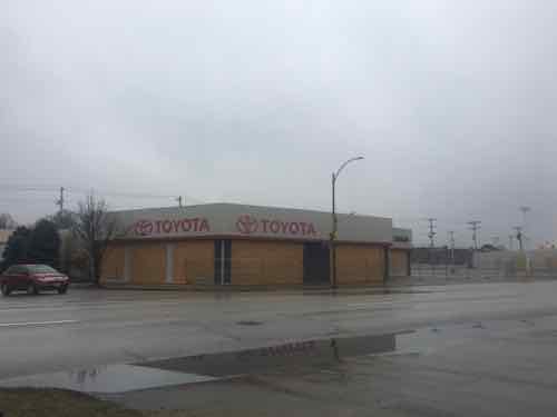
Today’s post isn’t about their new location, this is about the location they recently vacated.
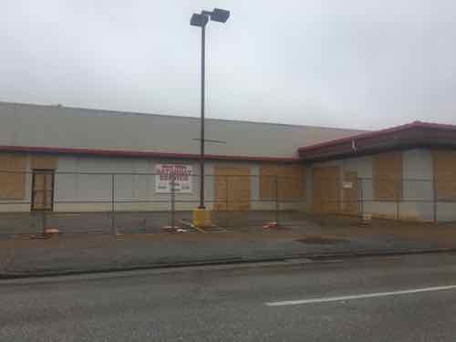
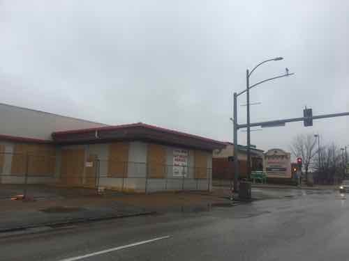
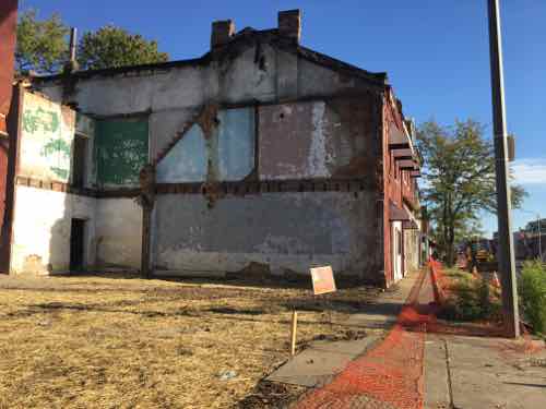
Their old address was listed as 3636 S. Kingshighway — the address for the building on the South, at Beck Ave. It dates to 1940, per city records online. The other building on Kingshighway, at Tholozan Ave. is from 1929. Both have been remodeled so many times neither has any historic value. A 3rd building, an anonymous service structure, facing Tholozan, was built in 1948.
The North building, at Tholozan, was their Scion showroom until Toyota pulled the plus on that youth-oriented brand. 2012 photoThat same building yesterday, all boarded up. Again, this structure was built in 1929. Note how it comes out to both Tholozan & Kingshighway. The city says the address here is 3608 S. Kingshighway.The South building is mostly set back from the property line.However, the corner at Beck Ave is out to the sidewalk. South of Beck Ave is Southtown Centre.
The former car dealership contains over 145k square feet, roughly 3.3 acres. It is made up of 6 different parcels. These could be combined, or developed separately. The most likely scenario is one developer will buy all six parcels and, after consolidating them into one, develop the total site.
Aerial view, from Apple Maps. The East edge of the site is a former railroad right of way, still owned by Union Pacific.
The bottom right section is 2 of the 6 parcels, it was still a field as late as 1971. It got paved for parking sometime between 1971 and 1991, based on historic aerials of the site. In the 2015 article, linked above, Jerry Ackerman is quoted as indicating they were seeing a franchise from another manufacturer for a dealership at this location. Given that they’ve boarded the buildings my assumption is that didn’t pan out.
Good.
This site needs to cease being about the sales & service of cars. It needs to be a mix of uses, including some residential. Two and three story buildings are very common on this stretch of Kingshighway, so a dense/urban site plan would be appropriate.
It’ll be interesting to watch to see what, if anything, becomes of this site.
October 23, 2017Featured, History/PreservationComments Off on Preservation Board To Consider Demolition Request For Historic Block On South Broadway In Carondelet Neighborhood
This afternoon the St. Louis Preservation Board will consider a request for demolition. an appeal, because the Cultural Resources director initially denied the request. The request is to raze an entire block of historic buildings on South Broadway. Broadway is one of the few streets in St. Louis that runs from far North to far South, so South Broadway isn’t specific enough. The East side of Busch Stadium is bounded by South Broadway. There’s an interesting stretch of South Broadway East of Soulard, in the Kosciusko neighborhood. The old Lemp Brewery complex is along South Broadway. The block being considered today is quite a bit further South, in the Central Carondelet Historic District. Most buildings in the district are residential, but the nomination mentions commercial as well:
Most of the commercial buildings in the district are located on Broadway, which supported an established business district long before the turn of the century. These buildings are grouped together by both use, stores and offices, and basic architectural form. Nearly all of the Commercial buildings in the district sit on the sidewalk line of their lots and are of one to three stories. Many of the commercial buildings employ similar stylistic characteristics as do residences in the district, such as parapet walls, similar cornice and window treatments and mansard roofs. Still,CommercialBuildings are in their own category,andwhen the building clearly shows the influence of a particular style it is placed in a sub-category of Classical Revival, Italianate, Second EmpireIMansard, or Art Deco.
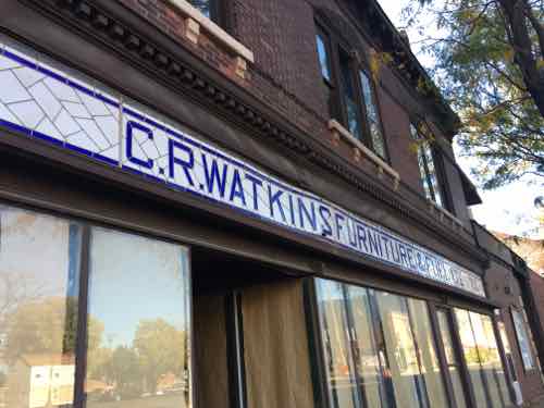
Watkins family history on this block goes back to 1879!
Very familiar with this part of South Broadway. It has some great old buildings, but little else. It’s just a pass through.
Still, these should be kept and someone work turning the area into a place where people want to be.
The 2nd pair of what I wrote, about place was missed by someone, who commented:
“Little else” besides eight bars (including two of the most vibrant live music venues to open in the City in the past two years), four antique stores, a bank, one of the oldest independent hardware stores in the City, the oldest convenience store in the City, and a gift shop recently named the 11th Ward business of the year. All in less than a one mile stretch on Broadway with this block in the direct center. It sounds like you don’t know too much about this stretch at all, particularly the reinvestment over the past few years.
I attempted to explain I was talking about the public realm, not private businesses by providing this definition and link:
Placemaking inspires people to collectively reimagine and reinvent public spaces as the heart of every community. Strengthening the connection between people and the places they share, Placemaking refers to a collaborative process by which we can shape our public realm in order to maximize shared value. More than just promoting better urban design, Placemaking facilitates creative patterns of use, paying particular attention to the physical, cultural, and social identities that define a place and support its ongoing evolution. (Project for Public Spaces)
This person instead I didn’t know the area, even though I had an office two blocks South for years. I knew all too well the pervasive thinking and poor quality of the public realm. However, I did learn through Googling they South Broadway Merchants Association changed its name to Carondelet Business Association.
Business districts, shopping centers, malls, etc must market themselves to attract businesses and visitors. The Carondelet Business Association, like the South Broadway Merchants Association fails to understand this reality. Commercial streets like Delmar and South Grand are commonly known as The Delmar Loop and Grand South Grand, respectively. These and other districts do a good job of marketing themselves.
What does the Carondelet Business Association do? It’s easy to find out about becoming a business member but trying to find a place to eat requires finding a 52-page PDF directory, restaurant listings begin on page 32. The CBA website was created and maintained by the owner who wants to raze an entire block of structures contributions to a historic district.
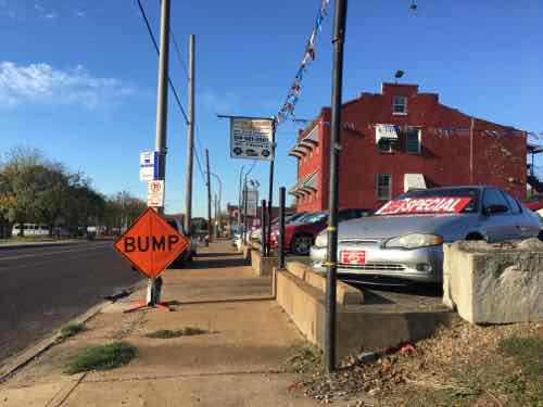
Like many, I’d driven through lately, but not stopped. So I took the MetroBus down to see what, if anything, had changed about the public realm — not what bars were now open.
I got off at Fillmore St, taking 90 photos as I traveled South 1.3 miles. I got back on the bus at Primm St (map). Here’s a few of the photos I took on the morning of October 18th:
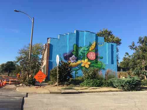
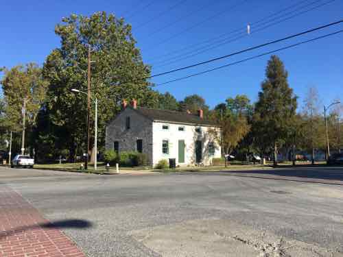
A mural & community garden was new to me.The used car lots weren’t newA building in the middle of another block had recently been razed.The bank building was boarded. This is across Broadway from the proposed demolitionThe sidewalks the entire 1.3 mile distance I traveled were in poor conditionA historic structure onion a small park is one of the few bright spots for public space in the area.
I don’t doubt many have worked hard, have good intentions. This stretch of South Broadway in Carondelet has great bones — unrealized potential. Place-making and business district marketing both take lots of skill to do successfully. Both need to happen or it’ll continue to struggle.
The Preservation Board meeting begins at 4pm, this is the 3rd item on the agenda.
Late last month a bar owner filed suit to stop enforcement of the smoking ban following the expiration of a previous exemption, which expired on January 2nd. Judge Dowd grated a temporary restraining order (TRO) until a hearing could be conducted — that hearing is scheduled for 10am today.
The exemptions are expiring for bars that make 25 percent or less of their income from food, are no larger than 2,000 square feet and do not allow anyone under 21 inside. But exemptions exist indefinitely for casino gaming areas, private clubs with no employees and tobacco retail stores. Bar owners who participate in Missouri Lottery’s keno program claim they can be considered a casino gaming area. The game requires the bars to be licensed as such. (Post-Dispatch)
So the argument is because they have a Club Keno game from the Missouri Lottery they should be exempt — just like a casino. Judge Dowd will, no doubt, look at St. Louis ordinance and Missouri law. Let’s take a look ourselves.
The Trophy Room, 5099 Arsenal. Click image to view location in Google Maps
St. Louis’ Smoke Free Air Act, passed in 2009, can be found here. In the definitions we see:
3. “Casino gaming area” means the area of a state-licensed gambling facility where gaming is allowed for those 21 years of age or older, including any VIP lounge, accessible only through the game floor, whether or not gaming is allowed in the VIP lounge.
Casino gaming area, not lottery area.
Section 7 of the Smoke Free Act is where “smoking is not regulated”, in the list is:
6. Casino gaming areas as defined by this Ordinance.
The ordinance uses the word “casino”, not lottery. Missouri law for the lottery is under different sections than for casinos, the Gaming Commission is totally separate from the Lottery Commission.
As you may know, the number of casino licenses in Missouri is limited to 13, from December 2010:
The Missouri Gaming Commission gave the green light to Creve Coeur-based Isle of Capri Corp. to build the state’s 13th casino just north of downtown Cape. After hearing passionate pitches for months, the commission made its decision quickly, quietly and unanimously. (Post-Dispatch)
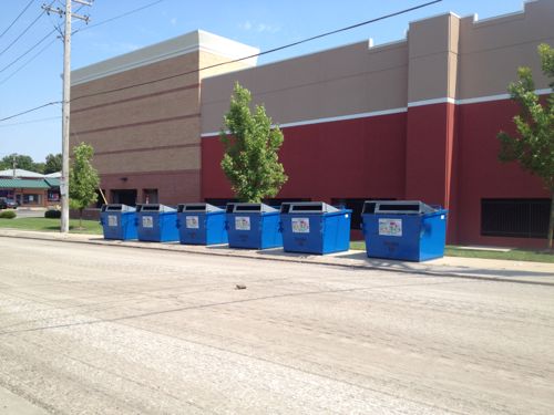
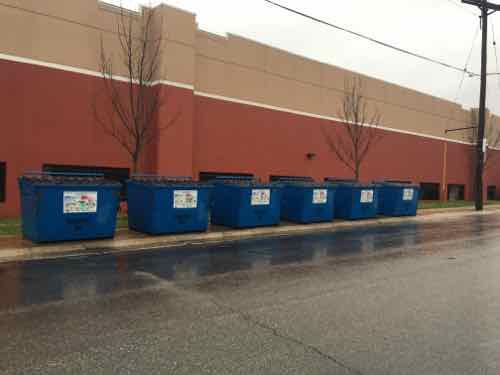
Over two years ago I posted about recycling dumpsters blocking a public sidewalk on the West side of Target, At the time Clifton Ave was being resurfaced so I wasn’t sure if they were on the sidewalk temporarily.
September 2013: The six recycling bins, oriented to the street, viewed from across Clifton Ave
In the time since I’ve noticed them still on the sidewalk, but I was passing by on Chippewa and couldn’t get a picture. Yesterday, Target had the Chippewa entrance to the lower level parking closed, so we turned onto Clifton Ave. — so I stopped the car to get a pic.
December 27, 2015. Click image to view in Google’s Street View
Recycling is important, but so are pedestrians! All pedestrians should be able to go from Chippewa to Bancroft — that’s why the sidewalk exists.
Here’s what needs to happen:
Move the bins into the street, OR
Add more sidewalk behind the bins, OR.
Relocate the bins elsewhere
I’d love to know who made the decision to block the public sidewalk.
One hundred years ago today St. Louis experienced deadly flooding. The problem wasn’t the Mississippi, it was the River Des Peres!
On the afternoon of Aug. 19, 1915, remnants of a hurricane reached St. Louis from Texas. Heavy and steady rainfall fell through the next day, dumping a total of 7.4 inches across the area. (6.85 inches on Aug. 20 remains the one-day record in St. Louis.)
The River Des Peres rushed from its banks, swamping long stretches of Delmar and Lindell boulevards, Manchester Avenue and other streets. People were stranded on the Wabash Railroad platform at Delmar (now a Metrolink station) by a seven-foot-deep current 200 yards wide. Firefighters reached them with ladders and used boats to rescue residents of Maple and Hodiamont avenues. (St. Louis Post-Dispatch — includes vintage photos)
In August 1915, St. Louis was flooded. All roads leading to the suburbs were cut off, and in Maplewood, the waters reached the second floor of some homes. The water was a mile-wide in Forest Park. Three bridges in the park were washed away, the Zoo’s Bird Cage and Bear Pits were flooded. The platforms at the old Delmar Station were destroyed. Passengers at the Wabash Station were surrounded by seven feet of water and had to be rescued by firefighters. Other people were trapped in their homes, and some even drowned. By the time the disaster was over, 11 people had died and more than 1,000 homes were lost.
The cause of the disaster was not the Mississippi River but the smaller River Des Peres, which ran along the City’s western edge.
River Des Peres, or “River of the Fathers,” was named after two Jesuit priests who founded a mission on its banks around 1700. Problems associated with flood and sewage control became obvious as St. Louis grew. In 1887, city officials planned to drain River Des Peres and Mill Creek. This plan was not completed, though, and River Des Peres had become an open sewer by the early 1900s. Parts of the river were covered or diverted in preparation for the World’s Fair in 1904, and monitoring of flooding conditions began in 1905. However, no steps had been taken by 1915 that could have prevented the devastating flood that same year. (St. Louis Public Library)
Perhaps the first sewage the River des Peres received was from St. Louis’ Central West End chamberpots. In response to the volume of waste, the city wrote an ordinance in 1887 “to prevent discharge of sewerage or offensive matter of any kind into the River des Peres.” If the city had funded the ordinance, then a separate sewer system would have been built and the River des Peres’ history might have taken a different course. Instead, the government of St. Louis began a trend that has plagued the river for more than a century: St. Louis would support ideas to protect the River des Peres as a sewer more than as a river.
As St. Louis grew westward, so did the expanses of pavement. With less open ground to soak up the rains, the River swelled with runoff. The River des Peres flooded in 1897, 1905, 1912, and 1913. The flood of 1915 killed 11 people and forced 1025 families from their homes. Flooding – not sewage – prompted St. Louisans to action. Mayor Henry W. Kiel called for a hydrologic study, which was completed by W.W. Horner and presented to the St. Louis Board of Public Service in 1916. St. Louis voters chose to implement Horner’s recommendations, which cost $11 million.
The project was called the River des Peres Sewerage and Drainage Works, and it took nine years to complete (from 1924 to 1933). Workers re-graded and paved the River’s banks and straightened its bends. Elsewhere the River was directed below ground to join with the sewer. The engineering innovations brought national recognition for Horner (who was also the project engineer). Scientific American and Engineering News-Record featured the marvelous new River des Peres. In 1988, the American Society of Civil Engineers recognized the project as a National Historic Civil Engineering Landmark. (River Des Peres Watershed Coalition)
The bond issue vote was in 1923 — 7 years after the plan was presented.
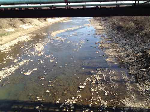
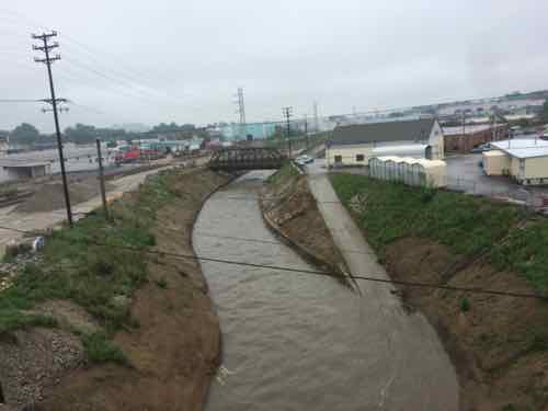
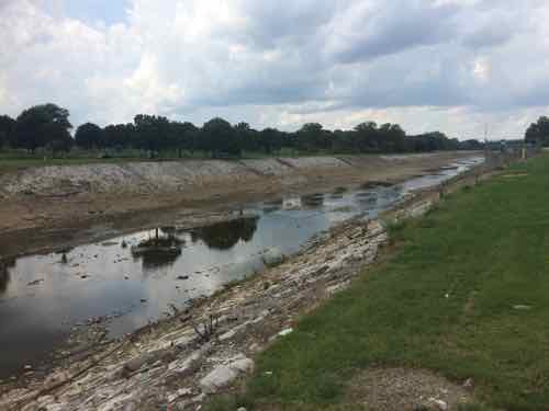
River Des Peres at S. Broadway, March 2012River Des Peres, looking East from Hampton, July 2015River Des Peres; looking North from Gravois. Tuesday August 18, 2015
Problem solved? Wrong.
Explore any city enough, and at some point you’re likely to walk on water, so to speak. San Francisco is full of ghost rivers. So are Washington, D.C. and Los Angeles. In the urban core of Baltimore, up to 98 percent of streams are underground.
Early city planners may have hoped for healthier cities when they covered up these streams, but it turns out they created new problems. Paving over and piping waterways often worsens flooding. And as new research by scientists at the Environmental Protection Agency indicates, buried streams can also exacerbate pollution.
In a paper published in PLOS ONE, lead authors and EPA research scientists Jake Beaulieu and Heather Golden found that nitrates—nutrients that can become pollutants—travel on average 18 times further in buried urban streams than they do in open streams, before they are taken out of the water column. (City Lab)
From February 2014:
Starting in a few days, MSD will begin construction of a 3,028 foot-long tunnel under the River Des Peres, just south of Carondelet.
The tunnel will hold a pressurized pipe that will carry sewage to the Lemay Wastewater Treatment Plant.
MSD spokesperson Lance LeComb said the new pipe will increase the plant’s capacity to take in sewage, and also serve as a back-up in case the existing “force main” ? which dates back to the 1960s ? has a problem.
The project is the first of about a dozen tunnels, totaling nearly 33 miles in length, that the MSD will be digging under St. Louis in the next couple decades. Most of the tunnels will hold a mix of stormwater and sewage. “The longest one will be nine miles long, running underneath the River Des Peres, almost 200 feet below ground,” LeComb said. “And 30 feet in diameter.” (St, Louis Public Radio)
Hopefully this will keep our sewage out of the waterways and not create more problems! The River Des Peres starts in St. Louis County, flash flooding remains an issue.
AARP Livibility Index
The Livability Index scores neighborhoods and communities across the U.S. for the services and amenities that impact your life the most
Built St. Louis
historic architecture of St. Louis, Missouri – mourning the losses, celebrating the survivors.
Geo St. Louis
a guide to geospatial data about the City of St. Louis