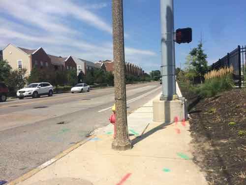
Yesterday’s post was about the bike lanes on Chouteau that aren’t there…yet. While I was photographing the absence of bike lanes late last month I noticed something else as I crossed Chouteau at Tucker. The annoying pedestrian crosswalk buttons aren’t next to the curb ramp where they should be.
I’m at the ramp to cross Chouteau going South, the pedestrian button is on the back side of the silver pole! The visible button the side of the pole to cross Tucker heading East.Looking back North you can see the pole and the ramp at the corner.
Pedestrian buttons should be reachable from the ramp, not 20 feet away! Personally I don’t think pedestrians should have to seek out and press button to get a walk signal — they should be automatic. Imagine driving and having to know just where to stop at a red light to give you a green light.
Pedestrian buttons are great for the sight-impaired. If done properly, once activated, it’ll verbally announce to the user when the walk sign is on and that it’s ok to cross. The rest of us shouldn’t have to press a button to get a walk signal.
Chouteau is maintained by MoDOT, I’ll alert them and the city about this.
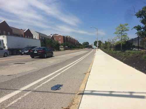
Last Monday I posted a detailed look at the new semi-protected bike lane on Chestnut Street, today a follow up to a January 2009 post on the narrowest bike lane. As was the case six+ years ago, the latest Bike St. Louis map (web | Scribd) shows bike lanes on both sides of Chouteau. Some say it had bike lanes at one time, but MoDOT restriped Chouteau and did away with them. What I saw in January 2009 was two solid white lines in the Westbound direction — they remained when I visited again on July 23rd.
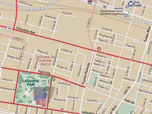
These lanes aren’t about bikes, they’re a way to narrow the outside drive lane from excess pavement.On the South side of Chouteau, also looking West from Tucker, we see a wide outside lane — no bike lane.
What
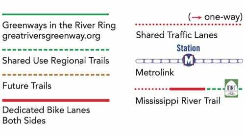
The map’s legend shows a solid red line as dedicated bike lanes in both directions, dotted red as shared lanes..This section of the map shows Chouteau in solid red.
Todd Antoine, from Great Rivers Greenway, told me MoDOT is starting now to resurface Chouteau, when finished it’ll be striped with dedicated bike lanes. The map available in January 2009 also showed dedicated bike lanes, I don’t know what maps in between indicated.
Given the road width I expect to see a reduction in the number of travel lanes from four to two, which shouldn’t be a problem given our light traffic. Still, it’ll likely upset those who want lots of wide lanes for cars.
Please vote in the poll, located in the right sidebar
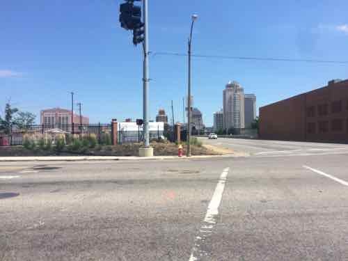
The latest controversy in St. Louis is over a proposed QuikTrip on the SW corner of Jefferson & Chouteau, you can view the site plan on Scribd.
For the poll today I’d like to see what readers think. Answers provided range for let them build it to deny it, with two levels of compromise in between. The poll is at the top of the right sidebar, it closes in 12 hours (8pm).
I’ll detail my thoughts on Wednesday when I share the results.
The Chouteau bridge (aerial) between 39th and Vandeventer opened on January 19, 2007 (source). The project to replace the old bridge was estimated at $16 million and “the construction contract was awarded to KCI Construction Company for $11.7 million.”
Knowing the bridge wasn’t very old I was surprised recently when I saw barricades on the south edge, then I received a press release from MoDOT:
ST. LOUIS – The Missouri Department of Transportation will close Chouteau Avenue (Route 100) between Vandeventer and Spring in both directions for periods of up to 10 minutes starting at 10 p.m. Tuesday, May 8. All lanes will be open by 6 a.m. Wednesday, May 9.
Crews are conducting load testing on the bridge to determine the best way to fix the sidewalk. The sidewalk has been closed since mid-2011. (MoDOT)
Fix a sidewalk on a five year-old bridge?
BIke/Walk Alert – Chouteau bridge between Vandeventer and 39th St.: During a recent inspection, MODOT found a crack in the sidewalk on the Chouteau Bridge and has closed the sidewalk while they investigate if the bridge is safe. MODOT plans to close one eastbound lane of Chouteau between Vandeventer and 39th and separate it from traffic with a concrete barrier. This lane will be a shared bike and pedestrian path until the sidewalk is repaired. Until the concrete barriers are in place, please use extreme caution when crossing the Chouteau Bridge or select an alternate route. Trailnet will post updates as we become aware of them. (Trailnet Facebook post on November 1, 2011)
With the barriers it’s possible to cross the bridge, although meeting someone in the middle would be a problem.
ABOVE: Looking east at the point where the sidewalk has been detouredABOVE: Paint on the new sidewalk in part of the outside drive laneABOVE: Markings and holes after the recent testingABOVE: Looking toward he main part of the bridge is west of Central Industrial DriveABOVE: Under the main spanABOVE: The sidewalk along the shorter span to the east is also closed so it must have a crack as wellABOVE: Looking west at the edge of the eastern span
I’ve not seen anything since the recent testing to indicate a solution. MoDOT hasn’t responded to my inquiry. Did Missouri get a warranty on this bridge?
Chouteau is too fat! Not the late Auguste Chouteau — I’m talking about the avenue named after St. Louis’ founder. Chouteau Ave has four travel lanes plus generous parking lanes, it’s too wide. I couldn’t find the curb-to-curb width but the public right-of-way (PROW) is a massive 80 feet, encompassing the road and adjacent sidewalks.
Recent road diet projects on Grand and Manchester had the number of travel lanes reduced from four to two. I don’t think that’s necessary or even a good idea on Chouteau. It’s not lined with shops, although some do still exist in places. No need to make Chouteau into a low volume shopping street but there is no reason it’s can’t accommodate the current volume of vehicular traffic AND be less hostile to pedestrians. This takes a corridor study.
Chouteau Ave extends east to the river and west until it becomes Manchester as it crosses Vandeventer, 3.4 miles long. The far east end isn’t as wide and is located in what will become Chouteau’s Landing. A corridor study should focus on the 3 mile stretch from S. 4th on the east to Vandeventer Ave on the west. The issues are similar end to end but I’ll use examples for the 6/10th of a mile section between Truman Parkway/18th and Jefferson Ave.
ABOVE: Pedestrians do exist along Chouteau
Chouteau is marked as 35mph, but given the generous widths traffic goes considerably faster.
ABOVE: Looking east on Chouteau Ave
Unlike Gravois and other roads, the right side of the outside lane isn’t marked to separate it from the parking lane. Visually this tells drivers the right lane is more than 20 feet wide compared to the 8-10 feet sufficient for a 35mph road.
ABOVE: Ameren’s green lawn doesn’t make the pedestrian feel less vulnerable
Only in a few areas does anyone park in the parking lane. , most of the time it’s vacant. Key to calming the traffic speeds is to visually reduce the perceived width of the road. This is accomplished by striping the outside lane and blub outs from the curb so the parking lane isn’t viewed as another travel lane.
ABOVE: At the end of Mississippi Ave bulbs helped provide room for the monument markers
The bulb outs at Mississippi Ave had nothing to do with calming the speeding traffic but providing room for pedestrians to get around the decorative markers. Still, the push out into Chouteau is helpful but one little spot on one side only isn’t enough. Traffic has a clear shot between Truman Parkway and Jefferson, more than a half mile without a signal, stop sign or even a crosswalk. That’s right, if you live on Mississippi Ave in Lafayette Square the only two safe places to cross Chouteau Ave is Jefferson Ave or Truman Parkway.
If I wanted to have lunch at Eleven-Eleven Mississippi I’d get off the bus at the stop were I took the above picture, cross and head up the street right? Wrong. Even the able-bodied risk getting hit by a car trying to cross such a wide street with fast traffic. For me, using a power chair, I’d have to go 2/10th of mile back to Truman Parkway to cross then 2/10th of a mile back to Mississippi Ave. Realistically I’d get off the bus closer to Truman but you get the point — I wouldn’t cross here because it’s too risky. In fact — I couldn’t cross the street because there aren’t any curb cuts to make it possible.
ABOVE: Vin de Set, PW Pizza, etc are popular destinations, causing people to cross Chouteau often
The bulb outs at Mississippi Ave have curb ramps to make it possible to continue parallel with Chouteau Ave. A corridor study of the 3 mile length of Chouteau Ave would identify key points where crosswalks are needed. Those not at intersections, like Mississippi Ave, would have a yellow caution light flashing overhead. In the 6/10th of mile between Truman Parkway and Jefferson Ave I’d suggest two pedestrian crossing points: Mississippi Ave and 22nd Street, this would equally space them 2/10th of a mile apart. Too far apart for a commercial district but adequate for this area.
This came to me recently when I attended an event at the new Sheet Metal Workers hall at Jefferson. Despite all the money spent the sidewalk wasn’t replaced.
ABOVE: Old sidewalk in front of new union hall
I asked Ald Kacie Starr Triplet about this at the event and she said the city will replace the sidewalk when funds are available. The sidewalk does need replacing but we should do so much more. I wouldn’t eliminate the parking lane but use bulbs to create end caps for parking and bus stop areas.
AARP Livibility Index
The Livability Index scores neighborhoods and communities across the U.S. for the services and amenities that impact your life the most
Built St. Louis
historic architecture of St. Louis, Missouri – mourning the losses, celebrating the survivors.
Geo St. Louis
a guide to geospatial data about the City of St. Louis