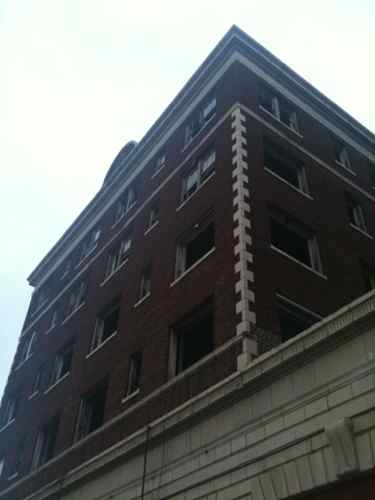
The vacant building at 4005 Delmar is an imposing structure, dwarfing neighboring buildings.
Boarded storefronts at sidewalk level
But the design is nearly perfect. The aesthetics are certainly appealing but I’m talking about how it relates to the sidewalk. Built in 1928, the building has 100 one-bedroom apartments, three larger apartments plus the storefronts. It occupies a lot that is just 150ft wide by 145 ft deep.
I see a modern streetcar coming West along Olive out of downtown. Just past Compton the streetcar would veer right to stay on Olive. For decades the streetcar did just this. At Vandeventer I would make a right turn to the North and then a left to head West on Delmar. The streetcar would pass directly in front of this building on the way to the Loop area further West on Delmar.
The modern streetcar would make the renovation of this building a feasible proposition. I can’t think of anything else that could happen that would put this building back into use. The vacant land in both directions along my proposed route would get redeveloped with new construction.
For years I’ve pictured myself living in this building and taking a streetcar East to Midtown and Downtown or West to the CWE or Loop. The location is ideal. This building is the ideal height for much of the city. Our main corridors could be lined with similar 5-story buildings. Many get all excited about high-rise towers making a statement on the skyline. Not me, this is far more exciting than any tower.
The term “blight” is often used when referring to old buildings, generally applied to the kind many of us see revitalized as part of a repopulated inner city. Most would consider the area at Page & Goodfellow (map) blighted. To me the source of the blight is not the earth 20th century buildings on a 19th century street grid. No, the blight comes from late 20th century failures:
This gas station is from 1987. Someone probably argued a shiny new gas station would revitalize the neighborhood. It didn’t and now it is bringing down the neighborhood.
City records show applications to construct a new station on the site: one in February 2008 and one in October 2009. Both applications are listed as “canceled.” Cheap auto-centric development in the city is about short-term profit, not a long term revitalization strategy. Gas station, strip shopping center, drive-thru restaurant, etc. are not going to help in the long term. In the short term they provide a way for politicians to talk about all the investment happening.
Cheap structures such as this can’t sustain themselves for more than two decades. They are quickly dated and there is almost always a newer version down the street.
Little along Dr. Martin Luther King Drive has changed since last year. Here is a look at the physical changes along the street that goes from downtown St. Louis to the city limits.
An auto-centric strip shopping center has opened. On-street parking now remains empty. Not an improvement.
The 3-story structure shown above was recently razed. It was located on the NW corner of MLK Drive and Arlington (map).
A couple blocks West a church has completed a new building. I like the massing, the glass, and the materials used. I don’t care for having a circle drive between the building and sidewalk.
If you are going to have such a drive this is the right way to do it, creating a planter to separate the circle drive from the sidewalk.
And at 18th & Dr. Martin Luther King Dr: a blank wall. Sorry, the color change doesn’t make it acceptable.
Dr. Martin Luther King Drive stretches from just North of downtown St. Louis out to the city’s municipal limits. It passes through areas best described as rough and others that have seen new investment and are on the way upward. In either case, where you have people you have pedestrians. Where you have low-income residents and public transportation you have more pedestrians than in higher income areas. All the more reason to ensure the public rights-of-way are designed for everyone: motorist, cyclist and pedestrian.
This is my sixth year writing about St. Louis’ Dr. Martin Luther King Jr. Drive.
Dr. Martin Luther King Dr. at Jefferson Ave.
About 6-8 years ago part of Dr. Martin Luther King Drive (Jefferson to Grand) got a makeover – new curbs and sidewalks. The width of the roadbed (curb to curb) was narrowed. A good thing? Yes and no. The entire stretch is poorly planned with respect to pedestrians. For those traveling parallel with MLK it is fine. But if you want to cross it can be a major challenge, only two proper crosswalks exist in the mile stretch.
So I want to show you this one mile stretch of roadway and the few places to cross. Above is our starting point at Jefferson Ave, (image at top, map). You see the single ADA curb ramp and crosswalk markings are directed East across Jefferson. For those seeking to cross MLK at Jefferson in a wheelchair the single ramp puts them dangerously close to passing cars.
MLK & N. Beaumont St.
A long block to the West of Jefferson is Beaumont St. intersecting with MLK from the South. Currently Beaumont’s sidewalks are a complete mess so nobody in a wheelchair would attempt to use them. One block away from this spot is where Lisi Bansen was struck by a car in 2005 as she wheeled in the street. Part of the idea behind new curbs, sidewalks and lighting is to make an infrastructure investment that results in increased development in the area. So while the total resident count in the immediate area is pretty low now my expectation is rebuilt streets be more than bling for passing motorists.
Continuing West we see more streets intersecting with MLK without provisions to cross the street:
Finally at Webster Ave. (map), on the West side of the intersection, we have a crosswalk. We are over a half mile from Jefferson Ave. Between these points we should have had 8-10 places to cross MLK.
One block further West we get the point where Compton meets MLK (map).  This intersection is big and complicated by three streets and angles. Pedestrians cannot cross MLK on this side.
On the West side they can cross. But note the places where a person going from one direction to the other is basically a sitting duck in the place where cars are turning. The point of bringing the curbs in to the center is to slow traffic and reduce the width required to cross the street. But for a pedestrian crossing in this crosswalk the width has not been reduced.
Continuing West:
At Francis St (above, map) we see Google Streetview managed to catch a person in the street in a wheelchair. My assumption is the person is waiting for a break in the traffic to cross MLK to the drive on the other side.
Grand is the street ahead. Pedestrians on the sidewalk to the right are just dumped out into a large & dangerous sea of asphalt.
This beauty of a street was outsourced by St. Louis’ Board of Public Service to the civil engineering firm of Kowelman Engineering, Inc. I’d give you a link to their website but they don’t have one. Their domain kowelman.com just takes you to a default temporary page. You can see their basic information on the city’s Disadvantaged Business Enterprise Program website here. Regular readers know Kowelman’s work, they are best known here for Loughborough Commons.
Engineers are great at determining water flows in the gutter, turning radii for curbs but unless their client is passionate about pedestrian issues the results will be largely superficial. In a mile stretch only two places were provided to cross MLK. Two! And they are one block apart from each other! Ideally this street will continue to get new structures, residents and businesses. That means more pedestrians – both able-bodied and disabled.   Shameful that good tax payer money was spent on such a poorly designed project.
The City of St. Louis is building two new large ($20 million + each) recreation centers, one just completed in Carondelet Park (map), on the south side, and one just getting started in O’Fallon Park (map), on the north side. As is typical of rec centers of this type, it turns out that access for people who won’t be driving seems to be both an afterthought and a real challenge. Bigger picture, this really shouldn’t be a surprise. There are three primary reasons. One, the majority of the users, especially the adult ones, WILL drive. Two, siting rec centers is a function of both budget and protecting departmental turf. And three, large rec centers, rightfully, generate the same NIMBY responses from many residential neighborhoods as many big-box retail developments – they operate long hours in large structures that generate a lot of traffic.
Parking at new Carondelet Rec Center, photo by Steve Patterson
When it comes to building new, modern, larger rec centers, rarely are there “enough†funds to do everything one would want to include, so the first decision is usually to locate the rec center in a park; after all, the land is/would be “freeâ€, there is no specific line item for land acquisition. In reality, it’s never free. One, parkland is a finite resource, with multiple demands from multiple user groups to accommodate their programs. Land dedicated to a rec center and its parking lots can’t be used for, for example, soccer fields or Frisbee golf. And two, like any other greenfield development, utilities need to be extended from the park boundary into the site. Since these are large, multi-million dollar public investments, there’s also a tendency to want to make them monuments, and what better place to put one, where it will remain visible, for decades.
Both of these centers are/will be prominently located, visible from neighboring interstate highways (I-70 on the north, I-55 on the south). While this may be good for the civic and political egos, as well as for marketing their programs, it means that both utilities and pedestrians will need to travel a lot further from any park boundary to reach them, to say nothing of the physical barrier the highway creates. There’s also an assumption that there is a need to connect rec center activities with other park uses and facilities. In reality, there’s rarely little, if any, interaction among uses, although a few staff members may end up multi-tasking. For example, the locker rooms used for the gym and the pool don’t get used by softball players or picnickers, and home runs hit over the outfield fence don’t interact well with either the outdoor pool deck or a parking lot full of parked cars. Still there’s an inherent desire in any department to protect turf – if they give up a program, that can mean a reduction in both staffing and budget.
In the case of the new Carondelet Rec Center, the nearest bus stop is on South Grand, at Holly Hills Avenue, approximately 3 blocks from the rec center’s front door. Getting there, as a pedestrian, is possible – there is a sidewalk, but one that follows a circuitous route, first south on Grand to Holly Hills Drive, then east across an ancient (and non-ADA-compliant) bridge over the railroad tracks, then south along the east side of the new parking lot. It looks good, and somewhat “easyâ€, but if you’re riding the bus, because you’re young or disabled or just don’t want to drive, 3 blocks is still 3 blocks, especially when compared to all the free, at-the-door, parking offered to those who drive.
North entrance to park, no pedestrians access to rec center at left. Photo by Steve Patterson
With the clarity of 20/20 hindsight, I would’ve preferred to have seen both rec centers sited much closer to a major public street, and potentially located closer to the population centers of both sides of town. I also would have had no problem locating them outside a park, on land already under the control of the St. Louis Development Corporation. When I was researching both sites, I made the mistaken assumption that the north center was being located on the southwest corner of Taylor and Broadway, behind Metro’s North Broadway Metro Bus Center; there was dirt being moved on what appeared to be an ideal, and very-accessible, site. It turns out that, much like on the south side, that the north side rec center will be located near the center of O’Fallon Park:
httpv://www.youtube.com/watch?v=IUtG-9eo2JQ
And no, this isn’t unique to St. Louis. Whether it’s Richmond Heights or Des Peres, St. Peters or Fenton, Kirkwood or Chesterfield, most new rec centers end up being located in recreation complexes, ideally suited for the proverbial soccer moms (and dads) and their mini-vans, but not so much for even local kids on their bikes. To move away from an auto-centric urban environment, we need to be doing more of what Clayton has done, either consciously or by coincidence, and less of what St. Louis and too many other suburban cities have done and continue to do.
The just opened rec center on the South side is operated by the YMCA as the Carondelet YMCA.
AARP Livibility Index
The Livability Index scores neighborhoods and communities across the U.S. for the services and amenities that impact your life the most
Built St. Louis
historic architecture of St. Louis, Missouri – mourning the losses, celebrating the survivors.
Geo St. Louis
a guide to geospatial data about the City of St. Louis