Few vacant buildings in St. Louis are as captivating to me as midtown’s Sun Theater. Why is that? The massing & detailing is pleasant but not extraordinary. The materials used compliment each other nicely. But what if the neon sign were gone? See a nighttime photo of the sign at Cinema Treasures.
Michael Allen successfully argues the appeal is not the sign, but the facade:
The Sun’s main attraction is its gorgeous neoclassical front elevation, articulated by glazed cream terra cotta, a projecting cornice and striking framed brick panels. The terra cotta includes theatrical grotesques over the arched windows at center and in the cornice’s upper garland course. These grotesques and other pieces are accented with a brilliant blue glaze. Two fluted pilasters with ionic capitals at the center bay over the entrance project a sense of gravitas contrasting with the more Baroque sensibilities of the rest of ornament.
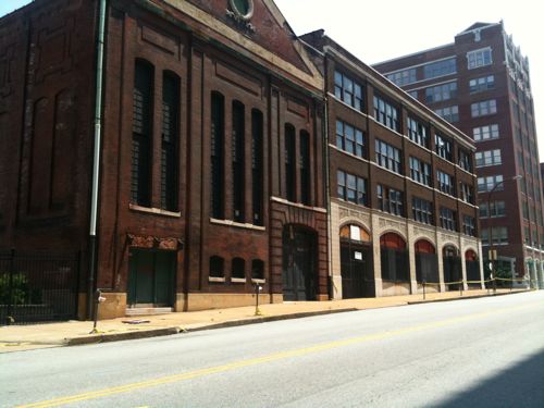
Putting the *Sun Theater at 3627-31 Grandel Square on our endangered list is merely an early warning. The pedestrian-friendly Renaissance Revival theater, built by the German Theater Society in 1913 from plans by Widmann & Walsh, is graced by an elaborately decorated front elevation complete with grotesque theatrical masks and heavy garlands. Inside, the $120,000 playhouse originally featured an 1800-seat, first-floor theater for German-speaking stock companies; a lecture hall was located on the second floor. The 1915 City Directory documents the two original names in use at the same time: The Victoria Theatre and The German Theatre.
With World War I came a national backlash against Germans and the theatre closed. Reopened after the war under new management as The Liberty, the building (with seating reduced to 1000) has since housed movies, vaudeville, burlesque, a night club and an evangelical church. (Later name changes included the World, the Sun and the Lyn.) LANDMARKS’ Midtown National Register nomination from 1978 described the remains of the interior as follows: “Bits of maroon, red and gold are faintly visible through the gloom of an interior picked by scavengers.” Vacant since 1981 and now owned by the city’s Land Reutilization Authority (LRA), the exterior (sporting volunteer trees and a cheerful “Sun” sign installed and maintained by Grand Center) is starting to show alarming signs of deferred maintenance. Recent hopeful rumors suggest that a media-related reuse is under consideration.
Apparently the Grand Center Arts Academy plans to renovate the building as an expansion of their newly renovated space next door, to the east. Let’s hope they, or anyone, renovates and occupies the structure soon.
The city of St. Louis is divided into 28 wards and each alderman has authority over his/her ward, the city as a whole be damned.
ABOVE: Current Preservation Review map, white areas are excluded. Click to download PDF.
As the above map show, eight of the twenty-eight wards are excluded from the city’s other  Preservation Review Districts:
Any demolition application in a Preservation Review District will be referred by the Building Division to the Cultural Resources Office for review. No demolition permit may be issued without the approval of the Office.
Criteria for Review:
The Office will consider these criteria in making its determination:
redevelopment plans passed by ordinance;
the building’s architectural quality;
its structural condition;
the demolition’s effect on its neighborhood;
the building’s potential for reuse;
urban design factors;
any proposed subsequent construction;
any commonly-controlled property.
So in 30% of the city buildings can be razed without any review by the staff hired to protect our cultural history. There are some exceptions, such as the 7th ward. It appears the CBD does have preservation review and other parts of the ward would be reviewed as part of of a National Register historic district. The same thing occurs in parts of the other seven non-review wards. Forget Team Four, lack of preservation review in six north side wards has done great damage.
But ward boundaries change this year due to redistricting. Preservation Review districts don’t automatically change, these must also be changed with new legislation. Â That is, unless it was simplified and covered the entire city. Here is an example of the description of one of twenty districts:
PRESERVATION REVIEW DISTRICT THIRTEEN
Beginning at the intersection of the centerlines of Kingshighwayand Lindell, and proceeding in a generally clockwise direction east along the centerlines to Taylor, north to Maryland, east to Boyle, south to West Pine, east to Sarah, south to Laclede, east to Spring, south to Market, east to Grand, north to the Forest Park Parkway, east to Compton, south to Chouteau, west to Grand, south to Park, west to 39th, south to Blaine, west to Tower Grove, south to Interstate 44, west to Kingshighway, north to the St. Louis & San Francisco Railway tracks, west to Hampton, north to Manchester, west to Graham, north to Oakland, east to the southern prolongation of Euclid, north to Barnes Hospital Plaza, west to Kingshighway, and north to the point of beginning. (source)
Think of all the staff time to write new legislation, to alter the city’s property database.
ABOVE: The vacant transit substation & Dragon Trading buildings in the 17xx block of Locust may lose preservation review protection.
My loft will go from being in the 6th ward to the 5th ward, from preservation review to non-review. The buildings above, in the block to the west of me, Â will also go from 6th to 5th, will suddenly be at greater risk of being razed without public input once the preservation review districts are revised. The substation is on Landmark’s 2010 Most Endangered List.
ABOVE: Butler Bros Warehouse, as seen from my windows, will be at risk when it gets placed in the 19th ward of Ald Marlene Davis
All this is to introduce the poll question for this week:Â Should Preservation Review be Citywide or Continue Ward-by-Ward? Â The poll is located in the upper right corner of the blog.
ABOVE: Hyatt Regency Kansas City as seen from the Crown Center Skywalk
Tomorrow evening marks the 30th anniversary of the walkway collapse at the Hyatt Regency Crown Ceenter in Kansas City:
The Hyatt Regency hotel walkway collapse was a collapse of a walkway that occurred on July 17, 1981, in Kansas City, Missouri, United States, killing 114 people and injuring 216 others during a tea dance. At the time, it was the deadliest structural collapse in U.S. history.
On July 17, 1981, approximately 1,600 people gathered in the atrium to participate in and watch a dance competition. Dozens stood on the walkways. At 7:05 PM, the second-level walkway held approximately 40 people with more on the third and an additional 16 to 20 on the fourth level who watched the activities of crowd in the lobby below. The fourth floor bridge was suspended directly over the second floor bridge, with the third floor walkway offset several meters from the others. Construction difficulties resulted in a subtle but flawed design change that doubled the load on the connection between the fourth floor walkway support beams and the tie rods carrying the weight of both walkways. This new design was barely adequate to support the dead load weight of the structure itself, much less the added weight of the spectators. The connection failed and the fourth floor walkway collapsed onto the second floor and both walkways then fell to the lobby floor below, resulting in 111 immediate deaths and 216 injuries. Three additional victims died after being evacuated to hospitals making the total number of deaths 114 people. (Wikipedia)
A “subtle” design change resulted in the deaths of many people.
ABOVE: Hyatt Regency Crown Center Lobby, December 2010
I started architecture school just four years after this accident occurred. Â This tragedy, and others, were discussed over and over, especially in structures courses. More from Wikipedia:
Investigators, including David Tonneman (a respected engineering critic), concluded that the basic problem was a lack of proper communication between Jack D. Gillum and Associates, Christopher Willoughby (a University of Michigan engineering student at the time), and Havens Steel. In particular, the drawings prepared by Jack D. Gillum and Associates were only preliminary sketches but were interpreted by Havens as finalized drawings. Jack D. Gillum and Associates failed to review the initial design thoroughly, and accepted Havens’ proposed plan without performing basic calculations that would have revealed its serious intrinsic flaws — in particular, the doubling of the load on the fourth-floor beams.
The engineers employed by Jack D. Gillum and Associates who had approved the final drawings were convicted by the Missouri Board of Architects, Professional Engineers, and Land Surveyors of gross negligence, misconduct and unprofessional conduct in the practice of engineering; they all lost their engineering licenses in the states of Missouri and Texas and their membership with ASCE. While Jack D. Gillum and Associates itself was discharged of criminal negligence, it lost its license to be an engineering firm.
This Hyatt Regency was, and is, owned by a subsidiary of Hallmark.
Hallmark was the driving force behind the Crown Center redevelopment:
Before the First World War, Downtown Kansas City was heavily populated and bustling. The area today home to Crown Center was an extension of the Union Hill historic neighborhood. Gradually, however, the center of population for the metro area moved south, and by the Second World War the area today comprising Crown Center had become dilapidated. Although Hallmark had maintained its headquarters at 26th Street and Grand Avenue since 1922, the headquarters itself and nearby Union Station comprised the only non-slum in the area. Instead, what there was were old warehouses, used car lots, and vacant buildings.
In 1966, Donald J. Hall, Sr. became President and CEO of Hallmark Cards, taking over from his father, Joyce Hall. Joyce Hall had long wished to develop the area around the corporate headquarters, and with his new leadership Donald Hall quickly made it known that he wished to renew the area entirely. Hallmark quietly began acquiring all the property surrounding its headquarters, and consulted with urban planning experts about the possibility of creating an experimental “city within a city” on the property. The City of Kansas City formally approved the plans for Crown Center (named after the Hallmark corporate symbol) by the end of 1967. (Wikipedia)
Crown Center wasn’t Urban Renewal.  Instead it was an early example of an http://en.wikipedia.org/wiki/Model_Cities_Program
To city planners, Crown Center is a mixed-use redevelopment, one of the earliest in the nation, on an 85-acre site adjacent to the international headquarters of Hallmark Cards, Inc. It has been a catalyst for change in the city’s urban core, replacing blight with quality working, living and entertainment facilities to breathe life back into the city.
Victor Gruen & Associates of Los Angeles developed the project’s original master plan, which was then modified and implemented by Edward Larrabee Barnes of New York. Crown Center was announced to the public in January 1967, and ground broke on September 16, 1968, for the first phase of the project – an underground parking facility, five-building office complex and landscaped central square. (PDF of Crown Center History)
Victor Gruen is the father of the shopping mall with the open-air Northland Center (1954), enclosed Southdale Mall (1956) and pedestrianization of a street with the Kalamazoo Mall (1959).  I’m not a fan of Gruen’s centralized designs.
I’m also not  a fan of Crown Center. I am a fan of making sure those who must be diligent to protect the safety of the public are checked and double checked.
ABOVE: Just one small section remains on the east face of Council Towers
A brick sculpture once covered the east facade of the 27-story Council Tower Senior building. Here is the description when the 5-building Council Plaza complex was listed on the National Register of Historic Places in 2007:
A 250 foot relief sculpture was designed and created in brick by artists Saunders Schultz and William Severson, nationally known sculptors and is visible on the St. Louis skyline on the east elevation. The bas relief carving took 15 months to complete and used about 100,000 brick. The sculpture utilizes a series of abstract arch geometric designs representing, “man’s continual striving toward God.” The artists also designed a small fountain within the complex and a sculpture within the fountain, Catfish and Crystal.
For a picture with the relief sculpture intact see this post at Saint Louis Patina or earlier discussion at NextSTL. I’m saddened by the removal of this sculpture.
Pretend for a moment the modest stone church at the the NE corner of Manchester & McKnight was built in 1945. It would be old enough to be historic just based on age. In reality, though, the church was built by slaves in 1845. The City of Rock Hill, where the church is located, took it’s name from the church. Serious history!
Rock Hill has foolishly agreed to allow a developer to raze the recently vacated church for a gas station and convenience store. Seriously.
The 1845 limestone church, located at McKnight and Manchester roads, could very well be razed to make way for a gas station and convenience store. Rock Hill Presbyterian Church is one of the earliest churches to be established in the greater St. Louis area. Until August 2010, it was the oldest Presbyterian Church west of the Mississippi to hold worship services on a continuous basis in the same structure, according to a history from the Rock Hill Historic Preservation Commission.
U-Gas, based in Fenton, has reached a purchase agreement with the property owner, Presbytery of Giddings-Lovejoy Inc.
Adjoining the church on the same property is the city-owned Fairfax House. The house was built between 1839 and 1842.
Plans call for the house to be moved to the northern end of the two-acre tract, with the move paid for by U-Gas. Bill Biermann, the attorney representing U-Gas, spoke at the July 5 board of aldermen meeting. (Source)
Incredibly shortsighted! It sounds like the purchase agreement is contingent on being able to build the gas station, so it may be possible to save the last bit of history in the area.
ABOVE: The modest church was rebuilt following a fire in the early 20th century
However, the developer must wait  6 months to see if someone can be found to relocated the stone structure. In the meantime, those seeking gas in the area will have to hope they have enough fuel to drive 825 feet further west, or another 1,200 feet beyond that.
ABOVE: Former gas station across McKnight to the west
The Fairfax house has been moved three times already, the most recent in 1997 from property across Manchester Rd.
The lovely timber frame home known as Fairfax is built to fit the Golden Mean in architecture. The appealing structure of four rooms joined with a central hallway is held together with tenon joinery, its frame resting upon massive oak sills hand hewn on site. Each window and door is delicately held together with a series of carefully placed hand carved wooden pegs. Delicately carved muntins lay across the panes of glass in the double hung window sashes. A brick lined food cupboard reaches floor to ceiling in the dining room and two massive Rumford Chimneys reach from cellar floor through rooftop. The hand turned newel post is still pinned underneath the first floor visible from the basement after being in constant use for some 160 years! (source)
The house would be moved a fourth time.
ABOVE: in the background is the 1950s addition designed by P. John Hoener & Associates and the Fairfax House
To see the architect’s sketch of the addition click here.
ABOVE: Fairfax House
I propose that, if the church is razed, the city change it’s name to one of the following:
U Gas Hill
Gas Hill
Sprawl Hill
Un-Rock Hill
Driving through Rock Hill is pretty depressing, these two structures are the only thing pleasant along this stretch of Manchester Rd. Take them away and there will be no relief from the sprawl.
AARP Livibility Index
The Livability Index scores neighborhoods and communities across the U.S. for the services and amenities that impact your life the most
Built St. Louis
historic architecture of St. Louis, Missouri – mourning the losses, celebrating the survivors.
Geo St. Louis
a guide to geospatial data about the City of St. Louis