February 23, 2020FeaturedComments Off on Sunday Poll: Excited by the XFL?
Please vote below
Professional football returns to St. Louis today.
After nearly five years, there will finally be a home professional football game at The Dome at America’s Center.
You could say they’ve got the best selling merchandise of any team, sold out the lower bowl of the dome and have one of the biggest followings of any XFL franchise at this point.
All of those statements about St. Louis BattleHawks would be true, but that doesn’t surprise the nearly 30,000 fans expected to pack The Dome Sunday afternoon. (KSDK)
The XFL is a new league with 8 teams, all owned by Vince McMahon’s Alpha Entertainment. Since today is the first home game for the St. Louis BattleHawks I thought it was a good time to see if readers are excited by the team, or not.
This poll will automatically close at 8pm tonight.
February 21, 2020Board of Aldermen, FeaturedComments Off on St. Louis Board of Aldermen: New Board Bills Week 33 of 2019-2020 Session
The St. Louis Board of Aldermen meet at 10am today, their 28th meeting of the 2019-2020 session. As previously noted, they have the first two meetings labeled as Week #1, so they list this as week/meeting 32.
B.B.#224 – Coatar – An ordinance recommended by the Board of Public Service to conditionally vacate above surface, surface and sub-surface rights for vehicle, equestrian and pedestrian travel in City Block 181 as bounded by Locust, 7th, Olive and 8th Streets in the City of St. Louis, Missouri, as hereinafter de- scribed, in accordance with Charter authority, and in conformity with Section l4 of Article XXI of the Charter and imposing certain conditions on such vacation.
B.B.#225 – Hubbard – An Ordinance Authorizing the Execution of a Maintenance Agreement for InterCo Plaza, and containing a Severability Clause.
B.B.#226 – Hubbard – An Ordinance Authorizing the Execution of a Cooperation Agreement for Portions of Hadley Street and Dr. Martin Luther King Drive, and containing a Severability Clause.
B.B.#227 – P. Boyd – An ordinance regulating the storage, transportation and disposal of waste tires; and requiring waste tire haulers to register with the Department of Public Safety, and tire dealers, waste tire processing facilities, and waste tire holding sites obtain permits from the Department of Public Safety; and providing penalties for violations of the provisions thereof; and containing an effective date, and severability clause.
B.B.#228 – Muhammad – An ordinance amending Ordinance 70714 by repealing Section Two of that ordinance and enacting in lieu thereof a new Section Two pertaining to the same subject matters; and adding Section Three containing an emergency clause.
B.B.#229 – Spencer/Coatar – An ordinance directing the Director of Health of the City of St. Louis to compile a list of organizations recognized by the Missouri Department of Mental Health as Recovery Community Centers that provide the substance abuse and recovery related, services and public health risk mitigation programs specified in the Section 1 of this ordinance, and to update and maintain current, said list; and containing an emergency clause.
B.B.#230 – Spencer/Coatar – An ordinance pertaining to the employees and volunteer of recognized Recovery Community Centers providing of sterile syringes and injection related supplies such as sterile water, cotton, and tourniquets to intravenous drug users as part of programs focused on the mitigation of public health risks associated with unsterile intravenous drug use, and providing limited protection from arrest and prosecution for violation of Section 11.61.020 governing the delivery of paraphernalia under those circumstances specified herein.
B.B.#231 – Spencer/Coatar – An ordinance amending Section 1 of ordinance 63800 codified in Chapter 25.64.010 of the City of St. Louis Revised Code of Ordinances to include a charge of $150.00 to cover the cost to the City for providing police security escort services during Building Division demolitions, repairs, board-ups, and clean-ups of buildings or structures that have been declared public nuisances.
B.B.#232 – Narayan – An ordinance pertaining to commercial vehicles, as such term is defined herein; and prohibiting such traffic along West Park Avenue from the eastern boundary of Hampton Avenue to the eastern boundary of Hugh’s Place; and exempting from said prohibition non-commercial pickup trucks, emergency vehicles, including privately owned tow trucks when providing emergency service to non-commercial vehicles, vehicles making deliveries to nearby addresses, and vehicles with a Gross Vehicle Weight (GVW) of ten-thousand (10,000) pounds or greater; and containing an emergency clause.
B.B.#233 – Guenther – An Ordinance repealing Ordinance No. 63107, which ordinance relates to a lease between The City of St. Louis, Missouri and Manufacturers Railway Company, a subsidiary of Anheuser-Busch Companies, Inc., authorizing the execution of a new Lease Agreement between the same parties under certain terms and conditions, for a period of five (5) years with four (4) five (5) year mutual options; and containing a severability clause.
B.B.#234 – J. Boyd – An ordinance authorizing and directing the Fire Commissioner, on behalf of the Mayor and the City of Saint Louis, to enter into and execute an Intergovernmental Transfer Agreement with the Missouri Department of Social Services MO Healthnet Division for a Ground Emergency Medical Transportation (GEMT) program for uncompensated Medicaid cost associated with GEMT services pursuant to RSMo 208.1032, establishing a fund from which to pay the non- federal share of the reconciled costs reimbursements and the administrative fee, providing for appropriation of the funds subsequently paid through the Missouri Department of Social Services, authorizing the expenditure of such appropriated funds by entering into contracts or otherwise upon approval of the Board of Estimate and Apportionment, and containing an emergency clause.
B.B.#235 – Middlebrook – An ordinance recommended by the Board of Public Service to vacate public surface rights for vehicle, equestrian and pedestrian travel in Tillie Ave. from Frederick to Newby and the 15 foot wide east/west alley in City Block 5430 as bounded by Tillie, Frederick, Baden and Newby in the City of St. Louis, Missouri, as hereinafter described, in accordance with Charter authority, and in conformity with Section l4 of Article XXI of the Charter and imposing certain conditions on such vacation.
B.B.#236 – Middlebrook – An ordinance recommended by the Board of Public Service to vacate public surface rights for vehicle, equestrian and pedestrian travel in a portion of Gilmore Avenue between Union Pacific Railroad Right of Way and Switzer Avenue in the City of St. Louis, Missouri, as hereinafter described, in accordance with Charter authority, and in conformity with Section l4 of Article XXI of the Charter and imposing certain conditions on such vacation.
B.B.#237 – Howard – An ordinance relating to the appointment of and salaries of certain Employees in the Collector of Revenue’s Office pursuant to Section 82.610, Revised Statutes of Missouri, by repealing Ordinances 70020; allocating certain other employees to a grade with rate; and including an emergency clause. The provisions of the sections contained in this ordinance shall be effective with the start of the first pay period following approval by the Mayor.
B.B.#238 – Ingrassia/Rice – An ordinance establishing a citizen commission to collect community input, gather information, conduct community outreach, study and create a new ward boundary map of the City of St. Louis.
B.B.#239 – Ingrassia – An ordinance amending Section 18, paragraph C. of Ordinance 68604, codified in Section 20.46.010 of the City of St. Louis Revised Code of Ordinances, concerning fees for street blocking permits; repealing the residential street blocking permit requirements and fees, and establishing in lieu thereof permit requirements and fees for high volume areas and low volume areas as such terms are defined herein; removing the one week cap on extending street blocking permits for containers, and instead requiring the approval of the Director of streets for such extensions, and establishing permit fees for street blocking permits for containers in high and low volume areas; and requiring justification of sidewalk closures and the implementation of measures to ensure mobility accommodations.
B.B.#240 – Howard – An ordinance to regulate employer and employee working relationships between the City of St. Louis and all employees under the Medical Examiner’s Office, including a compensation plan, terms and conditions of employment, benefits, leaves of absence, and authorization for a Deferred Compensation Plan; repealing Ordinance 70019; allocating certain other employees to a grade with rate; and including an emergency clause. The provisions of the sections contained in this ordinance shall be effective with the start of the first pay period following approval by the Mayor.
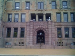
B.B.#241 – Davis – Pursuant to Ordinance 68937, an ordinance authorizing the honorary street name William A. Pearson Street, which shall begin at the intersection of North Cardinal Avenue and Franklin Avenue and run south on North Cardinal Avenue to the intersection of North Cardinal Avenue and Samuel Shepard Drive.
The Board of Aldermen meeting begins at 10am, past meetings and a live broadcast can be watched online here. See list of all board bills for the 2019-2020 session — the new bills listed above may not be online right away.
February 19, 2020Featured, Urban RenewalComments Off on Mill Creek Valley Neighborhood Was Less Important Than An Expressway
Since his arrival in St. Louis in 1915 Harland Bartholomew, a civil engineer by training, wanted cars to be able to move with greater ease. He relentlessly argued in favor of destroying the city’s rich urban fabric, street grid, in order to save the city from urban decay. He was young and charismatic, convincing generations of St. Louisans his way was the only way.
“Horizontal, black and white photograph showing a row of dilapidated residential buildings in the 3200 block of Lawton in Mill Creek Valley. The buildings appear to be empty and awaiting demolition. Low wooden fences enclose the small front yards. There are several inches of snow on the ground.” February 16, 1960. Missouri Historical Society
Lawton was an east-west street between Pine & Laclede, the above would’ve been just west of Compton Ave.
The chaos created by decades of Bartholomew’s projects created so much instability — far worse than than anything natural decay was creating. Widening streets and building new expressways was part of Bartholomew’s vision. It was costly but necessary, he argued.
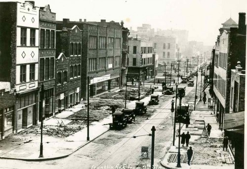
North edge of downtown: Franklin Ave being widened, looking East from 9th, 1928. Collection of the Landmarks Association of St Louis
In 1936 the first phase of a new expressway opened between Kingshighway and Skinner, cutting through the south edge of Forest Park. This was two decades before the creation of the Interstate Highway System! A year later another section opened between Vandeventer and Kingshighway. Many could see it reaching downtown eventually.
Highway planners in those days drew lines on map to connect the dots, sometimes meandering a bit here and there to avoid an important business, like Anheuser-Busch brewery in the case of what is now known as I-55. Otherwise their lines indiscriminately cut through neighborhood after neighborhood.
As these highways were going through the oldest parts of the city they were also going through the poorest neighborhoods. Older “slum” areas were viewed as obsolete anyway — two birds, one stone. By the 1959s Mill Creek Valley, bounded by Union Station on the east, railroad tracks on the south, Grand on the west, and Olive on the north, was a dense neighborhood.
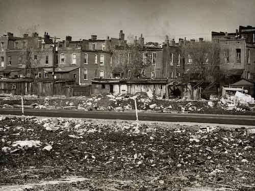
“Horizontal, black and white photograph showing a rear view of dilapidated housing in Mill Creek Valley. View was taken from an area across the street that has already been cleared. Bricks and other rubble is strewn throughout the foreground.” Missouri Historical Society
Because of segregation, it was self-contained. Yes, it was deteriorated and most residences lacked running water and indoor bathrooms. The buildings were nearly a century old. Numerous generations of new immigrants had begun their lives in America in this neighborhood, the last was southern blacks trying to escape Jim Crow laws while looking for work.
To an outsider it likely seemed like a horrible place, but to residents it was home. They had connections with each other, lasting institutions, etc. Poor neighborhoods all over the city were the same way, they didn’t look like much but it was the ties among the residents that was more important than the street grid or buildings. But take away the buildings and the streets and those strong ties among thousands quickly disappear. It’s an unnatural disaster.
During the 1950s, Saint Louis found itself in a fervor over urban deterioration and renewal. Following Mayor Joseph Darst’s 1953 slum clearance in the Chestnut Valley area, Mayor Raymond Tucker initiated a similar project in the adjacent Mill Creek Valley. This area – bounded by 20th Street, Grand Avenue, Olive Street and Scott Avenue – housed a large African-American population, and was at one time the home to such famous African-Americans as Scott Joplin and Josephine Baker. At the start of the 1950s, the Mill Creek Valley house 20,000 inhabitants (95% African-American) and included over 800 businesses and institutions. Everything the residents needed – from grocery, clothing and hardware stores to restaurants, schools and churches – was within walking distance of their homes. The area was also home to the prominent African-American newspaper, The St. Louis Argus. However, many of these residences and institutions were considered unsanitary and in need of repair.
In 1951, Missouri Governor Forrest Smith signed the Municipal Land Clearance for Redevelopment Law, which brought state aid to the urban renewal efforts of Missouri’s cities. The law also created the St. Louis Land Clearance for Redevelopment Authority, whose job it was to oversee urban renewal in Saint Louis and manage its funding. Under the 1954 Federal Housing Act – which provided federal aid for renewal projects – and the passage in 1955 of a $110 million bond issue, Mayor Tucker and the City of St. Louis began the clearance and demolition of slums in Mill Creek Valley. The most of the bond revenue went towards construction of new expressways, some of which cut through parts of Mill Creek. Roughly $10 million was utilized for slum clearance. The clearance of the area would involve the relocation of many residents and businesses; most residents would never return and many businesses would cease operations. Acquisition of buildings, like the Pine Street Hotel and the Peoples Finance Building, began in August of 1958, with actual demolition starting the following year. Redevelopment of the area would include new residential, commercial and industrial zones, with the majority of land going towards new industry. Certain industries that met zoning requirements, like Sealtest Foods, would not face demolition and were allowed to stay. Redevelopment of the entire area was scheduled for completion in 1968. (UMSL)
The city systematically created disasters all over the place. The pace must’ve been overwhelming to many at the time. Hundreds of thousands were uprooted. It’s a formula for the population losses that have happened since.
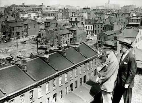
“Horizontal, black and white photograph showing Mayor Raymond Tucker and Sidney Maestre on a rooftop looking over dilapidated buildings slated for clearance in Mill Creek Valley. A note on the back of the print reads: “Mill Creek Valley, 1956 / Mayor Raymond Tucker and Sidney Maestre, Chairman of Citizens Committee which drafted bond issue program, are looking over decaying buildings in blighted area.””
Mill Creek Valley was at the wrong place at the wrong time. By 1950 Bartholomew was in Washington D.C., but his raze & replace attitude continued. Other options weren’t considered, especially when the land is needed for an expressway to connect downtown to affluent western suburbs as the wealthy continued moving westward along the central corridor.
Here are the results of the recent non-scientific Sunday Poll:
Q: Agree or disagree: Mill Creek Valley was a slum (no indoor plumbing, etc); leveling it was the only option
Strongly agree: 0 [0%]
Agree: 1 [5.56%]
Somewhat agree: 1 [5.56%]
Neither agree or disagree: 0 [0%]
Somewhat disagree: 1 [5.56%]
Disagree: 4 [22.22%]
Strongly disagree: 10 [55.56%]
Unsure/No Answer: 1 [5.56%]
Again, demolition was the only option considered. One, this generation didn’t see any value in the narrow & compact street grid or in 19th century flats. The other is they really wanted the land for a highway. As a bonus white folks could now drive on Olive & Market streets between the Central West End and downtown without having to go through a black neighborhood.
With so much uprooting & demolition it is amazing we have any residents or buildings left. The leaders at the time just couldn’t/didn’t see the tremendously negative consequences their actions would have on the city & region for decades to come. After all, everything they were doing was in an effort to save the city from decay.
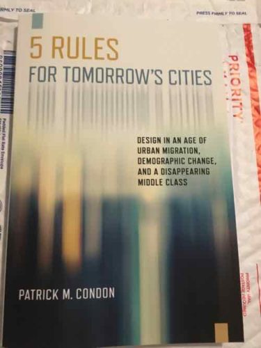
February 17, 2020Books, FeaturedComments Off on New Book — ‘5 Rules for Tomorrow’s Cities: Design in an Age of Urban Migration, Demographic Change, and a Disappearing Middle Class’
The times are changing, how we think about the design of cities also needs to change. The old ways just won’t cut it going forward. Thankfully people like Patrick M. Condon are thinking about the future of cities.
How we design our cities over the next four decades will be critical for our planet. If we continue to spill excessive greenhouse gas into the atmosphere, we will run out of time to keep our global temperature from increasing. Since approximately 80% of greenhouse gases come from cities, it follows that in the design of cities lies the fate of the world. As urban designers respond to the critical issue of climate change they must also address three cresting cultural waves: the worldwide rural-to-urban migration; the collapse of global fertility rates; and the disappearance of the middle class. In Five Rules for Tomorrow’s Cities, planning and design expert Patrick Condon explains how urban designers can assimilate these interconnected changes into their work. Condon shows how the very things that constrain cities—climate change, migration, financial stress, population change—could actually enable the emergence of a more equitable and resource-efficient city. He provides five rules for urban designers: (1) See the City as a System; (2) Recognize Patterns in the Urban Environment; (3) Apply Lighter, Greener, Smarter Infrastructure; (4) Strengthen Social and Economic Urban Resilience; and (5) Adapt to Shifts in Jobs, Retail, and Wages. In Five Rules for Tomorrow’s Cities, Condon provides grounded and financially feasible design examples for tomorrow’s sustainable cities, and the design tools needed to achieve them. (Island Press)
I generally like to share the table of contents, but the above publisher description lists the 5 rules, which are the main chapters. Google Books has a preview of selected pages, here. This is a well-sourced academic book, not a coffee table book.
This Day in St. Louis History, February 16, 1959: Mill Creek Valley becomes “Hiroshima Flats”
With $7 million from a 1955 St. Louis Civic Progress bond issue and $21 million in federal funds, the Land Clearance Redevelopment Authority began clearing the 454 acres of Mill Creek Valley, from Lindell on the north and Scott on the south, and Twentieth on the east and Grand on the west. The historically black area’s homes and dilapidated buildings were razed for 132 acres of industrial sites, 26 acres of commercial, 83 acres of residential, a 22 acre extension of St. Louis University across Grand, and the Ozark Expressway. 1,772 families and 610 individuals were displaced, some of the poorest in the city, and almost all black. Slow redevelopment after the rather quick destruction gained the giant empty fields of land the nickname of “Hiroshima Flats.” The Mill Creek Valley site is now covered by the portion of St. Louis University east of Grand, Harris Stowe State University, and the Wells Fargo Advisors buildings.
Here’s more:
By World War II, Mill Creek’s tenements and faded town houses were home to nearly 20,000 people, many of them poor blacks who had migrated north from the cotton fields. More than half the dwellings lacked running water, and 80 percent didn’t have interior bathrooms.
Tucker proposed knocking over nearly everything and starting over. In 1955, city voters overwhelmingly approved a $10 million bond issue for demolition, on the promise that the federal government would reimburse most of it. The local NAACP endorsed the idea. Work began on Feb. 16, 1959, at 3518 Laclede Avenue, where a headache ball smashed a house that dated to the 1870s. (Post-Dispatch)
On December 16, 1950, my grandmother purchased a house from her landlords, Richard and Betty Bennett, at 2649 Bernard Street in Mill Creek for $1,400. She had saved the $100 down payment from her meager salary. Twenty years after leaving Earl, Arkansas, for St. Louis, she would finally have a home of her own with her son, his wife, and their eight children. She would be the last in a long line of owners of the hundred-year-old Italianate- style two-story dwelling.
My grandmother was unaware of the city’s plans when she bought her house in the neighborhood where she had lived since leaving the South. However, politicians, realtors, and religious and business leaders knew what the future held for this 450-acre neighborhood. Egged on by a series of derisive articles in the local media, the city was moving to deem the area “blighted.” The designation would pave the way for the eventual erasure of an entire African American community to make way for an interstate highway to the suburbs.
There you have it, an overview of Mill Creek Valley. It was sixty-one years ago today that demolition began, so that’s the subject of today’s poll.
AARP Livibility Index
The Livability Index scores neighborhoods and communities across the U.S. for the services and amenities that impact your life the most
Built St. Louis
historic architecture of St. Louis, Missouri – mourning the losses, celebrating the survivors.
Geo St. Louis
a guide to geospatial data about the City of St. Louis

 The
The 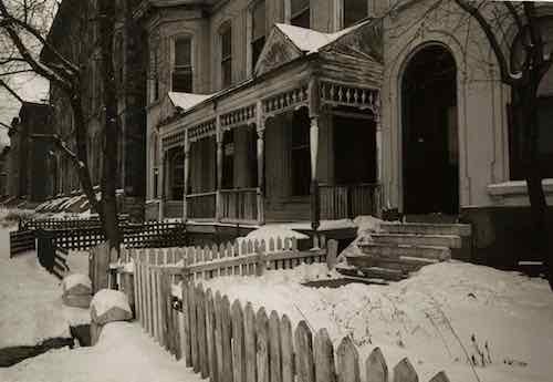
 The times are changing, how we think about the design of cities also needs to change. The old ways just won’t cut it going forward. Thankfully people like Patrick M. Condon are thinking about the future of cities.