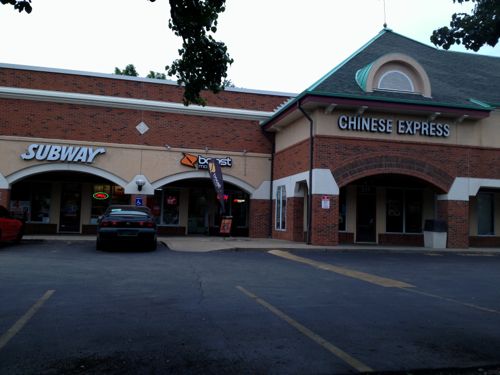
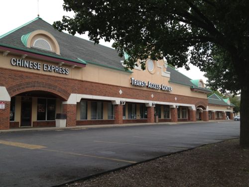
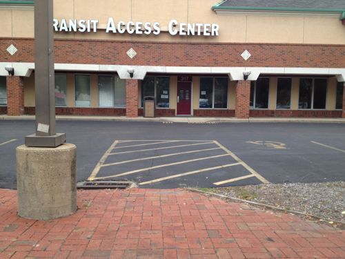
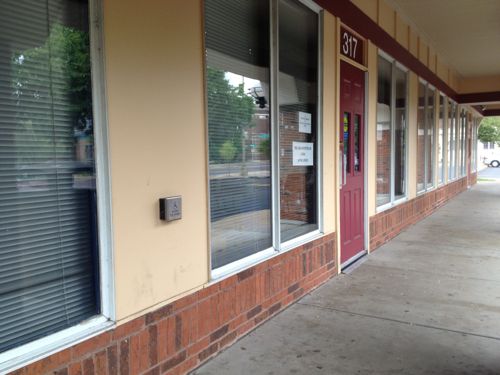
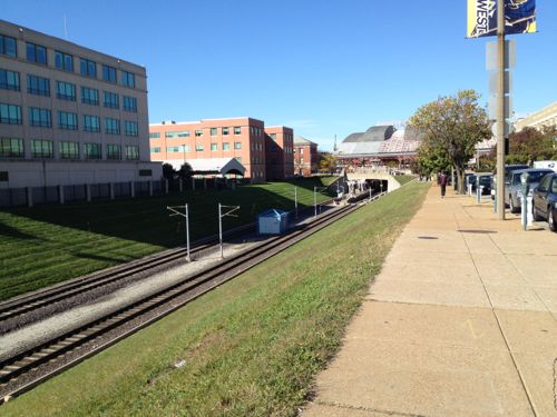
Seniors (65+) and the disabled can ride Metro for half price, but a reduced fare permit is required. Seniors have several options on obtaining such a permit, the MetroRide store downtown, for example. The disabled, like myself, must visit Metro’s Transit Access Center at 317 DeBaliviere. Let’s pretend we’re newly disabled and need to get a reduced-fare permit, for the first time. We arrive on the #90 (Hampton) MetroBus or via MetroLink at the Forest Park station. Remember this station opened twenty years ago, and was altered significantly in 2006 when the extension to Shrewsbury was built.
We get off the bus or come up from the platform on the east side of DeBaliviere and head north to find our destination.
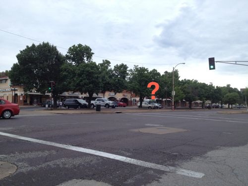
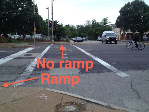
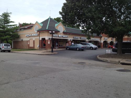
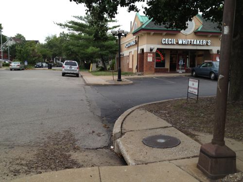
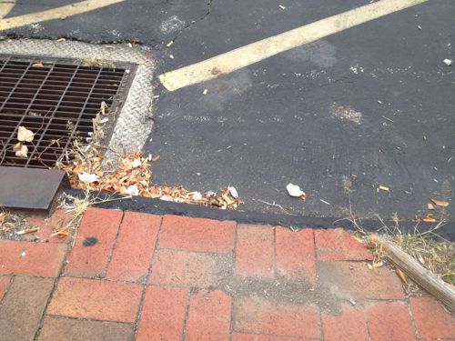
Based on the map online the Transit Access Center must be located in the strip mall over there.This curb ramp has nothing to do with the crosswalk, no curb ramp exists on the other end of the crosswalk. When the light turns green we’ll have to head over to the auto drive where cars will be leaving.Made it across safely, there’s our destinationDrat, no ramps on either side of the driveway! We could enter the auto driveway and hope we find a ramp before a vehicle backs over us, but none are visible from this point. Let’s continue along the public sidewalk to see if we can find another way in or our destination.There’s a ramp to the right of that car, we can’t reach it from here due to planter/curb/parking, We could go back and risk getting backed over or continue until we see our destination. I say we keep looking for a safe route.Oh, there’s the Transit Access Center, there must be a pedestrian route down further.See, I knew we’d find a direct way! Oh wait…Naturally a curb is in our wayAll the way on the far end is a route to reach the storefronts from the public sidewalk.We get to the door and we’re glad it has an automatic opener, but it doesn’t work when pressed. “It’s never worked”, says the person inside when we mention it.Leaving we see the problems from the other sideStill too risky to go behind parked cars, why must it be such a challenge?The fix here in this privstely-owned development is pretty simple actually, just replace a couple of curbs with ramps.
I’m not sure how long the Transit Access Center has been a tenant in this building, at least 4 years. The building was built in 1988, two years before the ADA and five years before the MetroLink opened. But for the last twenty years this development adjacent to a light rail station hasn’t been very accessible.
Again, this is the location every disabled person that seeks a reduced-fare permit must go. Granted, access from disabled parking is easy enough but many who need the permits can’t drive. For the disabled, independence is very important.
Regular readers know I’m a supporter of public transit, and an advocate for modern streetcars, in particular. When I received an email from a planning student asking about publishing her paper on her evaluation, I was curious. Here’s how Jill Mead described herself to me in that email:
I’m a Masters in Public Health and Masters of City Planning student at the University of North Carolina in Chapel Hill. I also work for the Pedestrian & Bike Info Center at UNC’s Highway Safety Research Center. If that weren’t enough, I’m very much a St. Louisan. I grew up in Forest Park Southeast (in the 80s!) and am a K-12 graduate of the SLPS. I went to UMSL for one year and Wash U for the rest of my college degree.
Though I don’t agree with her analysis and conclusions in the paper, I thought it would spur some good discussion. Here is a brief summary of her paper:
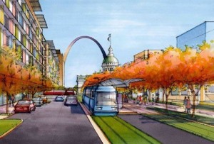
Artist rendering of proposed streetcar in downtown St. Louis.
Spurred by the availability of federal funds and inspired by the success of streetcar projects in other cities, the non-profit Partnership for Downtown St. Louis released a feasibility study for a downtown St. Louis streetcar project in March 2013. The feasibility study recommended the project based on its likelihood of achieving its two main objectives: (1) enhancing the region’s transit system and (2) catalyzing economic growth throughout the streetcar corridor. While the St. Louis Streetcar Feasibility Study is optimistic about the achievement of these two objectives, reviewing the study calls some of their claims into question. Ridership estimates seem inflated given the slow travel speeds of the streetcar and methodology used. The choice of alignment fails to prioritize the city’s densest areas and is out of sync with plans being made at the regional level. In terms of the streetcar’s ability to catalyze economic development in St. Louis, the study inadequately addresses the wide variety of contextual factors, such as land use policy and the existence of strong public-private partnerships and market demand that were characteristic of other cities’ success in attracting development to streetcar corridors. The paper concludes that strategies to improve economic growth and public transportation are necessary in St. Louis, but it is not clear that the proposed St. Louis Streetcar project is the best use of public resources to achieve these goals.
When St. Louis University announced plans to move their law school from midtown St. Louis to downtown, the Partnership for Downtown St. Louis once again began the discussion of a streetcar for downtown. This move presented an opportunity to link the two campuses with a streetcar and fulfill the goals of the Downtown Next Plan.
The idea of SLU running shuttle buses every day between midtown and downtown meant only a small segment of the population would be served, pollution would increase, roads would be see additional traffic from the continuous loop of shuttles. Us regular transit riders along Olive/Lindell would still have 30-40 minute headways on the existing #10 MetroBus. Why not improve the public transit system for all?
Connecting to south St. Louis wouldn’t help SLU with transporting students, faculty, and staff between the main campus in midtown and the new law school building downtown. By including a north-south segment on 14th the proposal recognizes future expansion into south & north city.
The existing MetroBus isn’t slow, it doesn’t take me long to get to the Central West End from my downtown loft, but the streetcar will come every 10-15 minutes instead of every 30-40 minutes — that’s far more important than whether it takes 8 minutes versus say 12-15 minutes to reach my stop! The streetcar will be faster than the bus, the center dedicated right-of-way, off-board fare payment, etc. will make the trip no longer than bus, very likely shorter. Buses are sometimes late; they get stuck in traffic, wheelchair lifts malfunction, rerouted around events, etc. When the bus takes 10 minutes to get to my stop but arrives 10 minutes late that puts me way behind. If I take the 30 minute earlier bus I arrive way too early and it uses more of my day.
Also from page 2 of the final study:
The purpose of the study was to:
support the goals established in The Downtown Next 2020 Vision to improve Downtown’s accessibility;
create a catalyst for continued economic development;
provide additional opportunities for alternative transportation;
support the region’s and City’s sustainability initiatives;
and promote an environment that will retain and attract new jobs and residents to the City.
I’ve invited Mead to come downtown and ride the #10 MetroBus with me, to midtown and back, to better understand the existing conditions, then I think she’ll see how the streetcar will be a potentially massive improvement. She’s in town visiting family, we’re talking about doing this later in the week.
Mead is correct when she said, “the study inadequately addresses the wide variety of contextual factors, such as land use policy.” The word “zoning” appears just four times in the final study report. “Proper zoning” is mentioned, but not defined. My fear is we won’t set up the necessary land-use controls to guide new development over the 10-20 years following the completion of the streetcar. If the prevailing Laissez faire attitude in St. Louis is allowed to squash good form-based zoning then the streetcar investment will be at least partially wasted.
But if we can get the formula right, it will be a boon and expansions can follow every few years, as we’ve seen in other cities. But I’ve been here long enough to know the old guard isn’t going to change so easily. Will this time be different?
Please share your thoughts on Mead’s paper, or my response, below.
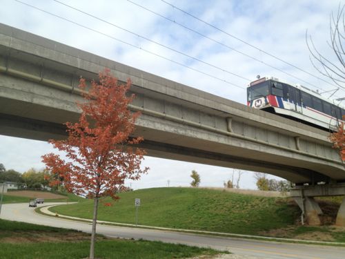
Today is the 20th anniversary of the opening of our original MetroLink light rail line. Since then we’ve added a line in Illinois and one in St. Louis County.
MetroLink train leaving the North Hanley station
One thing we haven’t really seen much of is transit-oriernted development (TOD). We’ve had a few projects that are, at best, transit-adjacent development (TAD).
TAD is TOD gone bad, development that is adjacent to transit but breaks all the rules that make TOD work, like making public spaces the focus of building orientation and neighborhood activity; creating pedestrian-friendly street networks that directly connect local destinations; and providing a mix of housing types, densities and costs. (TOD’s Evil Twin: Transit-Adjacent Development)
In the poll last week I asked about the lack of TOD in the last two decades:
Q: Why do you think our MetroLink light rail stations haven’t seen much transit-oriented development in the last 20 years? (Pick up to 3)
Lack of proper land-use controls, like form-based zoning 42 [13.21%]
Nobody pushed for TOD 37 [11.64%]
Regional fragmentation of leadership 37 [11.64%]
Regional job & population growth have been stagnant 37 [11.64%]
The station designs aren’t conducive for infill development 31 [9.75%]
Located in bad locations. 29 [9.12%]
The alignment isn’t convenient to many 27 [8.49%]
No demand for transit-oriented development 23 [7.23%]
We naively thought if we built it they’d come 17 [5.35%]
Used mainly for games, events, to reach Lambert airport 15 [4.72%]
Another reason not listed 10 [3.14%]
Our laissez-faire love of the free market 8 [2.52%]
Naysayers muted initial enthusiasm, halting TOD potential 4 [1.26%]
Park & ride lots are the best use of the land at the stations 1 [0.31%]
Unsure/no answer 0 [0%]
All of the above (except #14) are valid reasons, I think they ended up in about the right order too. A form-based code at the Wellston station would’ve required St. Louis County Economic Council building to acknowledge the presence of light rail.
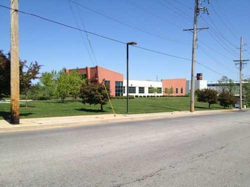
The St. Louis County Economic Council building abuts the station but doesn’t even have a sidewalk to the front door, located as far away from transit riders as physically possible.
When the county government doesn’t do set a good example, how can we expect others to do better on their own?
In the last couple of years there has been a TOD push. Better late than never or too little, too late?
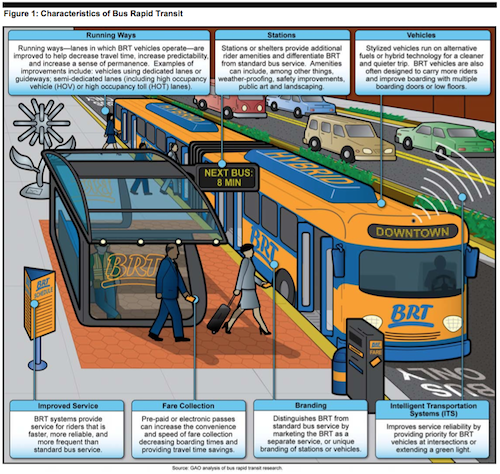
Bus Rapid Transit (BRT) has been used effectively in cities all over the world to improve public transit service, over previous bus service. With the proposed St. Louis Streetcar now going through the approval process some have suggested BRT as a less costly alternative. Seemed like a good reason to begin looking at the similarities and differences.
Similarities between BRT and modern streetcar:
Fewer stops than standard bus service, but more often than light rail
Faster on dedicated lanes, but can run in lanes stared with traffic
Unique branding that is distinct from local bus service
Higher capacities than bus service, though it varies depending upon the BRT vehicle
Increased ridership and development over bus
Differences between BRT and modern streetcar:
BRT can be re-routed, though stops are not changed easily. Streetcar routes unlikely to change due to capital costs.
Tracks & wires convey the message of transit even when vehicle not present, BRT is easier to ignore.
Many service enhancements are optional with BRT, thus BRT lite. These are not optional with streetcars.
Streetcar vehicles have a significantly longer service life than BRT vehicles.
Few can even agree on what minimum combination of service enhancements are necessary to be called BRT, the US Government Accountability Office says, “BRT generally includes improvements to seven features–running ways, stations, vehicles, intelligent transportation systems, fare collection, branding, and service.”
Source: United States Government Accountability Office’s July 2012 report “BUS RAPID TRANSIT Projects Improve Transit Service and Can Contribute to Economic Development” page 6, click to download PDF
Fare collection for standard buses is done as each passenger boards, whereas light rail systems use off-siteboard fare collection to reduce total boarding time. Modern streetcars, like light rail, tend to also use off-siteboard fare collection or on-board payment from one of several machines, allowing for faster boarding
Here’s a summary of what the GAO found out about BRT in the US:
U.S. bus rapid transit (BRT) projects we reviewed include features that distinguished BRT from standard bus service and improved riders’ experience. However, few of the projects (5 of 20) used dedicated or semi-dedicated lanes— a feature commonly associated with BRT and included in international systems to reduce travel time and attract riders. Project sponsors and planners explained that decisions on which features to incorporate into BRT projects were influenced by costs, community needs, and the ability to phase in additional features. For example, one project sponsor explained that well-lighted shelters with security cameras and real-time information displays were included to increase passengers’ sense of safety in the evening. Project sponsors told us they plan to incorporate additional features such as off-board fare collection over time.
The BRT projects we reviewed generally increased ridership and improved service over the previous transit service. Specifically, 13 of the 15 project sponsors that provided ridership data reported increases in ridership after 1 year of service and reduced average travel times of 10 to 35 percent over previous bus services. However, even with increases in ridership, U.S. BRT projects usually carry fewer total riders than rail transit projects and international BRT systems. Project sponsors and other stakeholders attribute this to higher population densities internationally and riders who prefer rail transit. However, some projects—such as the M15 BRT line in New York City—carry more than 55,000 riders per day.
Capital costs for BRT projects were generally lower than for rail transit projects and accounted for a small percent of the Federal Transit Administration’s (FTA) New, Small, and Very Small Starts’ funding although they accounted for over 50 percent of projects with grant agreements since fiscal year 2005. Project sponsors also told us that BRT projects can provide rail-like benefits at lower capital costs. However, differences in capital costs are due in part to elements needed for rail transit that are not required for BRT and can be considered in context of total riders, costs for operations, and other long-term costs such as vehicle replacement.
We found that although many factors contribute to economic development, most local officials we visited believe that BRT projects are contributing to localized economic development. For instance, officials in Cleveland told us that between $4 and $5 billion was invested near the Healthline BRT project—associated with major hospitals and universities in the corridor. Project sponsors in other cities told us that there is potential for development near BRT projects; however, development to date has been limited by broader economic conditions—most notably the recent recession. While most local officials believe that rail transit has a greater economic development potential than BRT, they agreed that certain factors can enhance BRT’s ability to contribute to economic development, including physical BRT features that relay a sense of permanence to developers; key employment and activity centers located along the corridor; and local policies and incentives that encourage transit-oriented development. Our analysis of land value changes near BRT lends support to these themes. In addition to economic development, BRT project sponsors highlighted other community benefits including quick construction and implementation and operational flexibility.
Here are more quotes from the same report:
Operating costs:
We also heard from stakeholders and project sponsors that operating costs for BRT and rail transit depend strongly on the density and ridership in the corridor. For example, according to one transit expert, while signaling and control costs are high for rail transit, there is a tipping point where given a high enough density and ridership, rail transit begins to have lower operating costs overall. (p31)
Land-Use:
BRT project sponsors and experts we spoke to told us that transit- supportive policies and development incentives can play a crucial role in helping to attract and spur economic development. Local officials in four of our five site-visit locations described policies and incentives that were designed (or are being developed) to attract development near BRT and other transit projects. For example, Los Angeles city officials told us that the city’s mayor recently created a transit-oriented development cabinet tasked with improving and maintaining coordination between Los Angeles Metro and city staff and developing policies and procedures in support of transit-oriented developments. They told us that the city is currently working on lifting requirements that require large amounts of parking and allow for only one- or two-story developments along many of the Metro Rapid lines. Officials in Eugene, Cleveland, and Seattle also told us that local governments either have in place, or are currently drafting, land use policies that are supportive of transit-oriented development. (p38)
Economic development:
Stakeholders also mentioned several factors that could lead to different amounts and types of economic development in BRT corridors compared to rail transit corridors. For instance, the greater prestige and permanence associated with rail transit may lead to more development and investment in rail transit corridors than in BRT corridors. Transit agency and other local officials also noted that BRT station areas might experience less investment and development than rail station areas because transit agencies may not own large amounts of land around BRT stations on which to build or support transit-oriented developments.43 Los Angeles city officials told us that one of the primary economic development benefits of light rail is that surplus property around the stations can be developed. Kansas City ATA officials told us that the agency owns only a few properties along Troost Avenue, which limits its ability to incentivize economic development in and around the BRT corridor. One real estate expert we spoke with noted that BRT may be better at supporting small- scale retail and residential developments, affordable housing developments, and medical facilities than rail transit, since these types of developments are often priced out of rail station-area markets. (p38-39)
This GAO report goes into great detail comparing BRT to light rail, but what about BRT vs modern streetcars? For that we can look at ongoing debate in the Washington DC suburb of Arlington VA:
The pro-streetcar group, Arlington Streetcar Now, wants to see the proposed streetcar become a reality on Columbia Pike between Pentagon City and Bailey’s Crossroads in Fairfax County (and potentially beyond), as well as a future streetcar from Pentagon City to Crystal City and then Potomac Yard in Alexandria.
It counters another new group, Arlingtonians for Sensible Transit, which launched in January. Its supporters say they want Arlington to study a “modern Bus Rapid Transit (BRT) system” along the Pike. (source)
Much has been written about streetcar vs BRT on the corridor they seek to improve. A good friend, and Arlington resident, thinks the streetcar idea is “stupid” and the proponent “arrogant.” My friend also likes living very close to a Metro station, which was far costlier than any streetcar, BRT or light rail.
The debate continues….
Even though a streetcar has significantly lower capital costs than a subway system, it is still a larger investment than a BRT system, sometimes costing twice as much. For example, Arlington’s Columbia Pike streetcar’s capital costs are around $51M/mile while Lansing’s Michigan/Grand River BRT is around $24M/mile (based on estimates found on their websites). However, streetcar systems bring with them benefits that BRT systems cannot leverage. Streetcars carry more passengers, more quickly, and they attract more “choice riders” and tourists, people who typically don’t feel comfortable riding a bus. Also, streetcars signal to the private sector that that corridor is important to the community; the predictability of transit service can bring increased economic development, thereby increasing local tax revenue, and garnering various community benefits. An commensurate increase in density can create places that enable people to drive less and walk, bike and ride transit more often. (source)
I like full BRT service and BRT lite over standard bus service, but neither have the potential to generate new high-density development the way streetcars can. Regardless of mode, BRT or streetcar, other factors such as good land-use regulations are an important factor in seeing development over the long-term. We skipped this important step when we opened our initial light rail line nearly 20 years ago, and along later expansions. We must get the land-use part right this time.
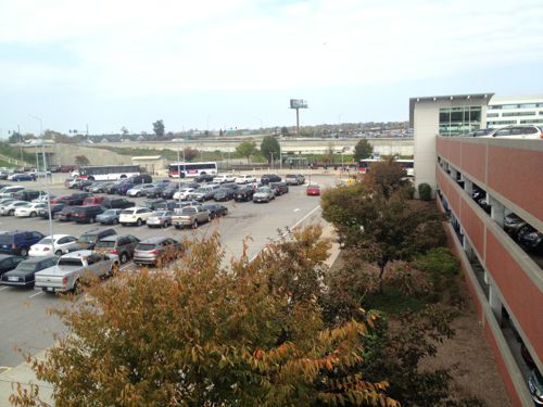
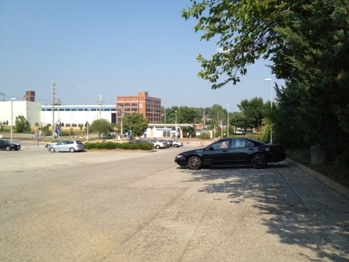
Looking west toward the Union Station MetroLink Station from 16th & Clark. The offices on the left aren’t oriented to transit, just adjacent.The only thing at the North Hanley station is 1,583 parking spaces (926 surface, 657 in garage)Not much exists around the Wellston Station, the jobs center in the background is hard to reach on foot, easy by car though
The poll this week lists many possible reasons why development hasn’t happened around the stations, you can pick up to 3. The choices are presented in random order.
On July 31st, MetroLink’s 20th anniversary, I’ll share my thoughts on why development hasn’t happened and what we need to do so the next 20 years are more productive.
AARP Livibility Index
The Livability Index scores neighborhoods and communities across the U.S. for the services and amenities that impact your life the most
Built St. Louis
historic architecture of St. Louis, Missouri – mourning the losses, celebrating the survivors.
Geo St. Louis
a guide to geospatial data about the City of St. Louis